Bagé
| Município de Bagé | |||
|---|---|---|---|
| Municipality | |||
 | |||
| |||
 Location in Rio Grande do Sul, Brazil | |||
| Coordinates: 31°19′51″S 54°06′25″W / 31.33083°S 54.10694°WCoordinates: 31°19′51″S 54°06′25″W / 31.33083°S 54.10694°W | |||
| Country | Brazil | ||
| Region | South | ||
| State | Rio Grande do Sul | ||
| Founded | 1811-07-17 | ||
| Government | |||
| • Mayor | Luís Eduardo Colombo dos Santos (PT) | ||
| Area[1] | |||
| • Total | 4,095.5 km2 (1,581.3 sq mi) | ||
| Elevation | 212 m (696 ft) | ||
| Population (2010)[1] | |||
| • Total | 116,792 | ||
| • Density | 29/km2 (74/sq mi) | ||
| Demonym(s) | Bageense | ||
| Time zone | UTC-3 (UTC-3) | ||
| • Summer (DST) | UTC-2 (UTC-2) | ||
| Postal code | 96400 | ||
| Area code(s) | (+55) 53 | ||
| Website | bage.rs.gov.br | ||

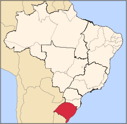
Bagé is a municipality in the south of the state of Rio Grande do Sul, Brazil. In 2007 its population was 164,550 (IBGE) in a total area of 4,096 km2. It was the tenth largest city in the state in 2007[2]
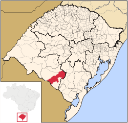
Location
Bagé is located 374 km. southwest of the state capital, Porto Alegre and approximately 60 km north of the border with Uruguay at Aceguá. The distance to Pelotas to the east on BR 293 is 180 km. Other distances from Bagé are:
Santana do Livramento: 170 km. Jaguarão: 199 km. Santa Maria: 250 km. See Aonde Fica and Prefeitura Municipal de Bagé for distances.
Comandante Gustavo Kraemer International Airport serves the city and the region although currectly no scheduled flights operate to and from it.
Climate
At an elevation of 242 meters above sea level just south of latitude 30° Bagé has a mild climate with maximum temperatures of 30 °C in January and 17 °C in June and minimum temperatures of 18 °C in January and 8 °C in June. Rainfall is spread out throughout the year with a maximum of 140.9 mm in July and a minimum of 103.1 mm in April.[3]
Economy
The economy is based on services, light industry and agriculture. Transformation industries employed 2,460 workers in 2006 while there were 1,199 agricultural establishments on 300,000 hectares employing 3,500 workers. There were 319,000 head of cattle and 103,000 head of sheep in 2007. The main crops were rice, corn, soybeans, sorghum, and wheat.[4]
History
Because of its location on the shortest route between Porto Alegre and Montevideu, Bagé has always played an important role in the history of Brazil and the state of Rio Grande do Sul. Its lands have been sought after by Indians, Portuguese, and the Spanish. Here were played out important events of the Cisplatine War and the Farroupilha and Federalist Revolutions.
The first contact between Amerindians (the Charruas) and the Spanish occurred in the second half of the seventeenth century when the Jesuits established a mission called Redução de Santo André dos Guenoas, in 1683.
In 1773, the governor of Buenos Aires, D. Juan José Vertiz y Salcedo, with 5,000 men, left the region of the Prata River to expel the Portuguese from Rio Grande do Sul. Arriving in this area he asked Bernardo Lecocq to build the Fort of Santa Tecla, of which there are still ruins.[5] The fort was surrounded by a ditch 9 meters wide and 2.5 meters deep, with a 3 meter high wall. This fort was sacked twice, the first in 1776 when Rafael Pinto Bandeira invaded and expelled the Spanish. After signing the Treaty of Santo Idelfonso in 1777 a Spanish garrison again occupied the fort now at the border between the two empires.
In 1801, the Spanish abandoned all their advanced posts, including Fort Santa Tecla, which was, for the second time, demolished. The territory was once again Portuguese who always desired the "European weather" of the area.
In 1810, some of the Spanish colonies broke free from the motherland. In 1811 the governor of Rio Grande do Sul, Dom Diogo de Sousa (later Count of Rio Pardo), concentrated a large force of Portuguese on the borderlands, fearing military action on the part of the newly formed Spanish republics. A camp was set up near "Cerros de Bagé", site where the city of Bagé is now located. On 17 July 1811 Sousa left with his troops to invade the Banda Oriental (present-day Uruguay) to conquer it and annex all the territory leaving the Uruguay River as a new border between Argentina and Brazil, some camp followers who could not keep up with the movement of the troops, who founded the present-day city. The date for the foundation of Bagé, 17 July 1811, was officially agreed on in 1963.
There are several theories as to the origins of the name of Bagé. One is that there was an Indian chieftain in the region called Ibajé, although the existence of this Indian has never been proven. A more accepted theory is that the name comes from the Indian language and is related to the idea of "hills". The local Indians called the hills "mbaiê".
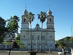
The settlement began to grow spreading out around the square called Praça da Matriz. In 1820 a simple church was built to house the image of the patron saint of the town, Saint Sebastian.
Even after the final demarcation of the border the lands of Bagé were the theater of wars and battles. In 1825 Carlos de Alvear invaded the territory from Uruguay and in 1827 the forces of general Lavalleja conquered the town. In 1828 a treaty brought peace to the borderlands. Brazil accepted Uruguay's independence but in exchange kept some of the borderlands previously disputed for centuries between Spain and Portugal.
In 1835 it was the Gauchos who were fighting among each other. This new conflict was due to the ideals of republicans and imperialists. Bagé one again was witness to battles and pillaging. One of the most important, the Battle of Seival, took place between imperialist and republican forces led by Antônio de Souza Netto. The latter was victorious and he proclaimed the República Rio – Grandense.
After this Farroupilha Revolution in 1846 Bagé was elevated to the category of "freguesia" and in the same year to "vila". In 1858 it was proclaimed head of the "comarca" and in 1859 it became a city.
Another revolution broke out in 1893 when the federalists reacted to the coming to power of the republicans. In this year Gumercindo Saraiva invaded Rio Grande do Sul and at Passo do Salsinho, the first combat took place. During this revolution the municipality was witness to the Battle of the Traíras, the Siege of Rio Negro, and the Siege of Bagé. At Rio Negro 300 prisoners had their throats cut. In the Siege of Bagé combats took place in the center of the town.
With the end of combats the beginning of the twentieth century seemed promising as Bagé had potential to become an industrial and agricultural center.
Narratives from this period show that the climate was benign and the soil rich in natural resources, with special mention of the coal mines of Candiota and Rio Negro. In the cattle raising sector Bagé was a large producer of sheep, cows and horses. Agriculture was less developed with the main crops being wheat and rice.
Bagé could count on considerable urban progress. The first railroad was inaugurated in 1884 with the finishing of the line to Rio Grande. Electrical lighting arrived in 1899, with Bagé being the first city in the state to have this important sign of progress. In 1913 a piped water system was installed.
Due to the importance of the city for the region it is called "Queen of the Border". It is the seat of the Universidade da Região da Campanha – URCAMP and is the seat of the Roman Catholic Diocese of Bagé.[6]
Health and education
In 2005 there were 32 health establishments of which 3 were hospitals. These hospitals offered 251 beds. In the education sector there were 18,000 students in 71 primary schools, 5,896 students in 14 middle schools, 1,931 students in 77 pre-primary schools. In addition there were 3,595 students in one private college.[4]
People from Bagé
- André Luís Garcia
- Carlos Kluwe
- Emílio Garrastazu Médici (President of Brazil)
- Cláudio Ibrahim Vaz Leal, better known as Branco (footballer)
References
- 1 2 (Portuguese) Cidades@, Brazilian Institute of Geography and Statistics, Accessed on 2007-05-04.
- ↑ Portal Brasil.
- ↑ Climate Charts
- 1 2 IBGE Archived January 9, 2007, at the Wayback Machine.
- ↑ Forte de Santa Tecla accessed 10 March 2012
- ↑ Prefeitura de Bagé
External links
| Wikivoyage has a travel guide for Bagé. |
 "Bagé". Encyclopædia Britannica. 3 (11th ed.). 1911.
- Guarany Football Club
- Grêmio Esportivo Bagé soccer club