Eygliers
| Eygliers | ||
|---|---|---|
|
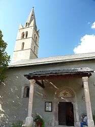
The church of Saint-Antoine, in Eygliers | ||
| ||
 Eygliers | ||
|
Location within Provence-A.-C.d'A. region  Eygliers | ||
| Coordinates: 44°40′37″N 6°38′04″E / 44.6769°N 6.6344°ECoordinates: 44°40′37″N 6°38′04″E / 44.6769°N 6.6344°E | ||
| Country | France | |
| Region | Provence-Alpes-Côte d'Azur | |
| Department | Hautes-Alpes | |
| Arrondissement | Briançon | |
| Canton | Guillestre | |
| Intercommunality | Guillestrois | |
| Government | ||
| • Mayor (2008–2014) | Jean Morel | |
| Area1 | 30.04 km2 (11.60 sq mi) | |
| Population (208)2 | 749 | |
| • Density | 25/km2 (65/sq mi) | |
| Time zone | CET (UTC+1) | |
| • Summer (DST) | CEST (UTC+2) | |
| INSEE/Postal code | 05052 / 05600 | |
| Elevation |
881–2,670 m (2,890–8,760 ft) (avg. 1,029 m or 3,376 ft) | |
|
1 French Land Register data, which excludes lakes, ponds, glaciers > 1 km² (0.386 sq mi or 247 acres) and river estuaries. 2 Population without double counting: residents of multiple communes (e.g., students and military personnel) only counted once. | ||

Eygliers is a commune in the Hautes-Alpes department in southeastern France.
Population
| Historical population | ||
|---|---|---|
| Year | Pop. | ±% |
| 1962 | 413 | — |
| 1968 | 414 | +0.2% |
| 1975 | 403 | −2.7% |
| 1982 | 502 | +24.6% |
| 1990 | 596 | +18.7% |
| 1999 | 697 | +16.9% |
| 2008 | 749 | +7.5% |
Geography
The river Guil forms all of the commune's southeastern and southern borders; the Durance forms part of its western border; most of the human settlements in the commune are located in its southwestern part, near the confluence of the two rivers.
See also
References
| Wikimedia Commons has media related to Eygliers. |
This article is issued from Wikipedia - version of the 9/17/2015. The text is available under the Creative Commons Attribution/Share Alike but additional terms may apply for the media files.