Saint-Martin-de-Queyrières
| Saint-Martin-de-Queyrières | ||
|---|---|---|
|
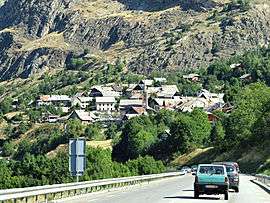
Saint-Martin-de-Queyrières seen from the RN94 road | ||
| ||
 Saint-Martin-de-Queyrières | ||
|
Location within Provence-A.-C.d'A. region  Saint-Martin-de-Queyrières | ||
| Coordinates: 44°50′28″N 6°35′10″E / 44.8411°N 6.5861°ECoordinates: 44°50′28″N 6°35′10″E / 44.8411°N 6.5861°E | ||
| Country | France | |
| Region | Provence-Alpes-Côte d'Azur | |
| Department | Hautes-Alpes | |
| Arrondissement | Briançon | |
| Canton | L'Argentière-la-Bessée | |
| Intercommunality | Pays des Écrins | |
| Government | ||
| • Mayor (2008–2014) | Pierre Denis | |
| Area1 | 55.52 km2 (21.44 sq mi) | |
| Population (2008)2 | 1,102 | |
| • Density | 20/km2 (51/sq mi) | |
| Time zone | CET (UTC+1) | |
| • Summer (DST) | CEST (UTC+2) | |
| INSEE/Postal code | 05151 / 05120 | |
| Elevation |
1,000–2,920 m (3,280–9,580 ft) (avg. 1,200 m or 3,900 ft) | |
|
1 French Land Register data, which excludes lakes, ponds, glaciers > 1 km² (0.386 sq mi or 247 acres) and river estuaries. 2 Population without double counting: residents of multiple communes (e.g., students and military personnel) only counted once. | ||

Saint-Martin-de-Queyrières is a commune in the Hautes-Alpes department in southeastern France.
Population
| Historical population | ||
|---|---|---|
| Year | Pop. | ±% |
| 1793 | 1,326 | — |
| 1800 | 1,388 | +4.7% |
| 1806 | 1,372 | −1.2% |
| 1821 | 1,451 | +5.8% |
| 1831 | 1,447 | −0.3% |
| 1836 | 1,530 | +5.7% |
| 1841 | 1,424 | −6.9% |
| 1846 | 1,417 | −0.5% |
| 1851 | 1,416 | −0.1% |
| 1856 | 1,420 | +0.3% |
| 1861 | 1,388 | −2.3% |
| 1866 | 1,346 | −3.0% |
| 1872 | 1,367 | +1.6% |
| 1876 | 1,440 | +5.3% |
| 1881 | 1,413 | −1.9% |
| 1886 | 1,807 | +27.9% |
| 1891 | 1,300 | −28.1% |
| 1896 | 1,312 | +0.9% |
| 1901 | 1,282 | −2.3% |
| 1906 | 1,210 | −5.6% |
| 1911 | 1,248 | +3.1% |
| 1921 | 1,093 | −12.4% |
| 1926 | 970 | −11.3% |
| 1931 | 1,008 | +3.9% |
| 1936 | 837 | −17.0% |
| 1946 | 699 | −16.5% |
| 1954 | 547 | −21.7% |
| 1962 | 516 | −5.7% |
| 1968 | 485 | −6.0% |
| 1975 | 449 | −7.4% |
| 1982 | 524 | +16.7% |
| 1990 | 707 | +34.9% |
| 1999 | 936 | +32.4% |
| 2008 | 1,102 | +17.7% |
See also
References
| Wikimedia Commons has media related to Saint-Martin-de-Queyrières. |
This article is issued from Wikipedia - version of the 1/31/2015. The text is available under the Creative Commons Attribution/Share Alike but additional terms may apply for the media files.