Laye
| Laye | ||
|---|---|---|
|
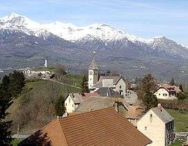
The church and the surrounding buildings in Laye | ||
| ||
 Laye | ||
|
Location within Provence-A.-C.d'A. region  Laye | ||
| Coordinates: 44°39′43″N 6°05′06″E / 44.6619°N 6.085°ECoordinates: 44°39′43″N 6°05′06″E / 44.6619°N 6.085°E | ||
| Country | France | |
| Region | Provence-Alpes-Côte d'Azur | |
| Department | Hautes-Alpes | |
| Arrondissement | Gap | |
| Canton | Saint-Bonnet-en-Champsaur | |
| Intercommunality | Champsaur | |
| Government | ||
| • Mayor (2008–2014) | Rémi Jouglard | |
| Area1 | 10.55 km2 (4.07 sq mi) | |
| Population (2008)2 | 231 | |
| • Density | 22/km2 (57/sq mi) | |
| Time zone | CET (UTC+1) | |
| • Summer (DST) | CEST (UTC+2) | |
| INSEE/Postal code | 05072 / 05500 | |
| Elevation |
976–2,158 m (3,202–7,080 ft) (avg. 1,200 m or 3,900 ft) | |
|
1 French Land Register data, which excludes lakes, ponds, glaciers > 1 km² (0.386 sq mi or 247 acres) and river estuaries. 2 Population without double counting: residents of multiple communes (e.g., students and military personnel) only counted once. | ||

Laye is a commune in the Hautes-Alpes department in southeastern France.
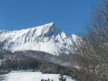
Pic de l'Aiguille
Population
| Historical population | ||
|---|---|---|
| Year | Pop. | ±% |
| 1962 | 125 | — |
| 1968 | 155 | +24.0% |
| 1975 | 137 | −11.6% |
| 1982 | 163 | +19.0% |
| 1990 | 192 | +17.8% |
| 1999 | 212 | +10.4% |
| 2008 | 231 | +9.0% |
See also
References
| Wikimedia Commons has media related to Laye. |
This article is issued from Wikipedia - version of the 1/30/2015. The text is available under the Creative Commons Attribution/Share Alike but additional terms may apply for the media files.