Barret-sur-Méouge
| Barret-sur-Méouge | |
|---|---|
|
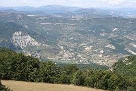
The village seen from the Col de Branche | |
 Barret-sur-Méouge | |
|
Location within Provence-A.-C.d'A. region  Barret-sur-Méouge | |
| Coordinates: 44°15′48″N 5°44′03″E / 44.2633°N 5.7342°ECoordinates: 44°15′48″N 5°44′03″E / 44.2633°N 5.7342°E | |
| Country | France |
| Region | Provence-Alpes-Côte d'Azur |
| Department | Hautes-Alpes |
| Arrondissement | Gap |
| Canton | Ribiers |
| Intercommunality | Ribiers Val de Méouge |
| Government | |
| • Mayor (2008–2014) | Bruno Lagier |
| Area1 | 26.72 km2 (10.32 sq mi) |
| Population (2008)2 | 214 |
| • Density | 8.0/km2 (21/sq mi) |
| Time zone | CET (UTC+1) |
| • Summer (DST) | CEST (UTC+2) |
| INSEE/Postal code | 05014 / 05300 |
| Elevation |
592–1,555 m (1,942–5,102 ft) (avg. 649 m or 2,129 ft) |
|
1 French Land Register data, which excludes lakes, ponds, glaciers > 1 km² (0.386 sq mi or 247 acres) and river estuaries. 2 Population without double counting: residents of multiple communes (e.g., students and military personnel) only counted once. | |
Barret-sur-Méouge is a commune in the Hautes-Alpes department in southeastern France. It is located at the start of the 'Gorges de la Méouge' on the Méouge river.
Population
| Historical population | ||
|---|---|---|
| Year | Pop. | ±% |
| 1962 | 179 | — |
| 1968 | 342 | +91.1% |
| 1975 | 291 | −14.9% |
| 1982 | 187 | −35.7% |
| 1990 | 237 | +26.7% |
| 1999 | 232 | −2.1% |
| 2008 | 214 | −7.8% |
See also
References
| Wikimedia Commons has media related to Barret-sur-Méouge. |
This article is issued from Wikipedia - version of the 9/16/2015. The text is available under the Creative Commons Attribution/Share Alike but additional terms may apply for the media files.