Forest-Saint-Julien
| Forest-Saint-Julien | ||
|---|---|---|
|
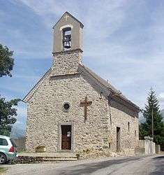
The chapel of Forest-Saint-Julien | ||
| ||
 Forest-Saint-Julien | ||
|
Location within Provence-A.-C.d'A. region  Forest-Saint-Julien | ||
| Coordinates: 44°38′05″N 6°08′11″E / 44.6347°N 6.1364°ECoordinates: 44°38′05″N 6°08′11″E / 44.6347°N 6.1364°E | ||
| Country | France | |
| Region | Provence-Alpes-Côte d'Azur | |
| Department | Hautes-Alpes | |
| Arrondissement | Gap | |
| Canton | Saint-Bonnet-en-Champsaur | |
| Government | ||
| • Mayor (2008–2014) | Fabrice Borel | |
| Area1 | 6.95 km2 (2.68 sq mi) | |
| Population (2008)2 | 276 | |
| • Density | 40/km2 (100/sq mi) | |
| Time zone | CET (UTC+1) | |
| • Summer (DST) | CEST (UTC+2) | |
| INSEE/Postal code | 05056 / 05260 | |
| Elevation |
1,015–1,631 m (3,330–5,351 ft) (avg. 1,200 m or 3,900 ft) | |
|
1 French Land Register data, which excludes lakes, ponds, glaciers > 1 km² (0.386 sq mi or 247 acres) and river estuaries. 2 Population without double counting: residents of multiple communes (e.g., students and military personnel) only counted once. | ||

Forest-Saint-Julien est une commune des Hautes-Alpes department au sud-est de la France.
Population
| Historical population | ||
|---|---|---|
| Year | Pop. | ±% |
| 1962 | 227 | — |
| 1968 | 231 | +1.8% |
| 1975 | 197 | −14.7% |
| 1982 | 177 | −10.2% |
| 1990 | 178 | +0.6% |
| 1999 | 218 | +22.5% |
| 2008 | 276 | +26.6% |
See also
References
| Wikimedia Commons has media related to Forest-Saint-Julien. |
This article is issued from Wikipedia - version of the 2/1/2016. The text is available under the Creative Commons Attribution/Share Alike but additional terms may apply for the media files.