Saint-Chaffrey
| Saint-Chaffrey | ||
|---|---|---|
|
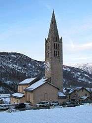
Parish church of Saint-Chaffrey | ||
| ||
 Saint-Chaffrey | ||
|
Location within Provence-A.-C.d'A. region  Saint-Chaffrey | ||
| Coordinates: 44°55′37″N 6°36′27″E / 44.9269°N 6.6075°ECoordinates: 44°55′37″N 6°36′27″E / 44.9269°N 6.6075°E | ||
| Country | France | |
| Region | Provence-Alpes-Côte d'Azur | |
| Department | Hautes-Alpes | |
| Arrondissement | Briançon | |
| Canton | Le Monêtier-les-Bains | |
| Intercommunality | Briançon | |
| Government | ||
| • Mayor (2008–2014) | Henri Raoux | |
| Area1 | 25.88 km2 (9.99 sq mi) | |
| Population (2008)2 | 1,662 | |
| • Density | 64/km2 (170/sq mi) | |
| Time zone | CET (UTC+1) | |
| • Summer (DST) | CEST (UTC+2) | |
| INSEE/Postal code | 05133 / 05330 | |
| Elevation |
1,274–2,632 m (4,180–8,635 ft) (avg. 1,365 m or 4,478 ft) | |
|
1 French Land Register data, which excludes lakes, ponds, glaciers > 1 km² (0.386 sq mi or 247 acres) and river estuaries. 2 Population without double counting: residents of multiple communes (e.g., students and military personnel) only counted once. | ||

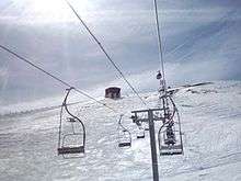
Chantemerle ski resort
Saint-Chaffrey is a commune in the Hautes-Alpes department in southeastern France.
Population
| Historical population | ||
|---|---|---|
| Year | Pop. | ±% |
| 1962 | 818 | — |
| 1968 | 831 | +1.6% |
| 1975 | 947 | +14.0% |
| 1982 | 1,287 | +35.9% |
| 1990 | 1,424 | +10.6% |
| 1999 | 1,569 | +10.2% |
| 2008 | 1,662 | +5.9% |
See also
References
| Wikimedia Commons has media related to Saint-Chaffrey. |
This article is issued from Wikipedia - version of the 2/18/2016. The text is available under the Creative Commons Attribution/Share Alike but additional terms may apply for the media files.