Saint-Jean-Saint-Nicolas
| Saint-Jean-Saint-Nicolas | ||
|---|---|---|
|
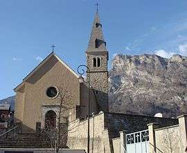
The church of Saint-Jean | ||
| ||
 Saint-Jean-Saint-Nicolas | ||
|
Location within Provence-A.-C.d'A. region  Saint-Jean-Saint-Nicolas | ||
| Coordinates: 44°40′06″N 6°13′46″E / 44.6683°N 6.2294°ECoordinates: 44°40′06″N 6°13′46″E / 44.6683°N 6.2294°E | ||
| Country | France | |
| Region | Provence-Alpes-Côte d'Azur | |
| Department | Hautes-Alpes | |
| Arrondissement | Gap | |
| Canton | Orcières | |
| Intercommunality | Haut Champsaur | |
| Government | ||
| • Mayor (2008–2014) | Josiane Arnoux | |
| Area1 | 37.17 km2 (14.35 sq mi) | |
| Population (2008)2 | 941 | |
| • Density | 25/km2 (66/sq mi) | |
| Time zone | CET (UTC+1) | |
| • Summer (DST) | CEST (UTC+2) | |
| INSEE/Postal code | 05145 / 05260 | |
| Elevation |
1,077–2,614 m (3,533–8,576 ft) (avg. 1,129 m or 3,704 ft) | |
|
1 French Land Register data, which excludes lakes, ponds, glaciers > 1 km² (0.386 sq mi or 247 acres) and river estuaries. 2 Population without double counting: residents of multiple communes (e.g., students and military personnel) only counted once. | ||

Saint-Jean-Saint-Nicolas is a commune in the Hautes-Alpes department in southeastern France.
Population
| Historical population | ||
|---|---|---|
| Year | Pop. | ±% |
| 1962 | 718 | — |
| 1968 | 695 | −3.2% |
| 1975 | 746 | +7.3% |
| 1982 | 823 | +10.3% |
| 1990 | 865 | +5.1% |
| 1999 | 781 | −9.7% |
| 2008 | 941 | +20.5% |
See also
References
| Wikimedia Commons has media related to Saint-Jean-Saint-Nicolas. |
This article is issued from Wikipedia - version of the 1/31/2015. The text is available under the Creative Commons Attribution/Share Alike but additional terms may apply for the media files.