Adams County, Pennsylvania
| Adams County, Pennsylvania | ||
|---|---|---|
|
| ||
| ||
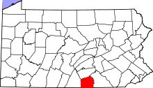 Location in the U.S. state of Pennsylvania | ||
 Pennsylvania's location in the U.S. | ||
| Founded | January 22, 1800 | |
| Named for | John Adams | |
| Seat | Gettysburg | |
| Largest borough | Gettysburg | |
| Area | ||
| • Total | 522 sq mi (1,352 km2) | |
| • Land | 519 sq mi (1,344 km2) | |
| • Water | 3.1 sq mi (8 km2), 0.6% | |
| Population (est.) | ||
| • (2015) | 102,295 | |
| • Density | 197/sq mi (76/km²) | |
| Congressional district | 4th | |
| Time zone | Eastern: UTC-5/-4 | |
| Website |
www | |
|
Footnotes: | ||
| Designated | November 06, 1982[1] | |

Adams County is a county in the U.S. state of Pennsylvania. As of the 2010 census, the population was 101,407.[2] Its county seat is Gettysburg.[3] The county was created on January 22, 1800, from part of York County and named in honor of the second President of the United States, John Adams. On 1–3 July 1863, Gettysburg and its vicinity was the site of the pivotal battle of the American Civil War, and as a result is a center for Civil War tourism.
Adams County comprises the Gettysburg, PA Metropolitan Statistical Area, which is also included in the Harrisburg-York-Lebanon, PA Combined Statistical Area.
Geography
According to the U.S. Census Bureau, the county has a total area of 522 square miles (1,350 km2), of which 519 square miles (1,340 km2) is land and 3.1 square miles (8.0 km2) (0.6%) is water.[4] The Borough of Gettysburg is located at the center of Adams County. This county seat community is surrounded on three sides by the Gettysburg National Military Park (GNMP). The Eisenhower National Historic Site adjoins GNMP on its southwest edge. Most of Adams County's rural landscapes and its mid-19th century roadway pattern remain intact today. Thirteen historic roadways converge at or near Gettysburg Borough. Two circular rings of towns surround Gettysburg; the first ring is typically found at a distance of about 7 miles (11 km) from Gettysburg. The second ring is found at a distance of 12 to 15 miles (24 km) from the County Seat. This "spokes and wheel" pattern represents one of the few examples of Central Place Theory in the Eastern United States.
The county is in the watershed of the Chesapeake Bay and is drained by the Susquehanna River and Potomac River.
Adjacent counties
- Cumberland County (north)
- York County (east)
- Carroll County, Maryland (southeast)
- Frederick County, Maryland (southwest)
- Franklin County (west)
National protected areas
Law and government
Presidential politics
Adams County is a Republican County, in 2016 Donald Trump carried the county with 66.3% of the vote to Hillary Clinton's 29.9%.
Pennsylvania House of Representatives
| District | Representative | Party |
|---|---|---|
| 91 | Dan Moul | Republican |
| 193 | Will Tallman | Republican |
United States House of Representatives
| District | Representative | Party |
|---|---|---|
| 4 | Scott Perry | Republican |
United States Senate
Demographics
| Historical population | |||
|---|---|---|---|
| Census | Pop. | %± | |
| 1800 | 13,172 | — | |
| 1810 | 15,152 | 15.0% | |
| 1820 | 19,370 | 27.8% | |
| 1830 | 21,379 | 10.4% | |
| 1840 | 23,044 | 7.8% | |
| 1850 | 25,981 | 12.7% | |
| 1860 | 28,006 | 7.8% | |
| 1870 | 30,315 | 8.2% | |
| 1880 | 32,455 | 7.1% | |
| 1890 | 33,486 | 3.2% | |
| 1900 | 34,496 | 3.0% | |
| 1910 | 34,319 | −0.5% | |
| 1920 | 34,583 | 0.8% | |
| 1930 | 37,128 | 7.4% | |
| 1940 | 39,435 | 6.2% | |
| 1950 | 44,197 | 12.1% | |
| 1960 | 51,906 | 17.4% | |
| 1970 | 56,937 | 9.7% | |
| 1980 | 68,292 | 19.9% | |
| 1990 | 78,274 | 14.6% | |
| 2000 | 91,292 | 16.6% | |
| 2010 | 101,407 | 11.1% | |
| Est. 2015 | 102,295 | [5] | 0.9% |
| U.S. Decennial Census[6] 1790–1960[7] 1900–1990[8] 1990–2000[9] 2010–2013[2] | |||
As of the census[10] of 2010, there were 101,407 people, 33,652 households, and 24,767 families residing in the county. The population density was 194 people per square mile (75/km²). There were 35,831 housing units at an average density of 69 per square mile (27/km²). The racial makeup of the county was 95.39% White, 1.21% Black or African American, 0.20% Native American, 0.49% Asian, 0.02% Pacific Islander, 1.71% from other races, and 0.97% from two or more races. 3.64% of the population were Hispanic or Latino of any race. 42.7% were of German, 14.1% American, 8.5% Irish and 7.1% English ancestry according to Census 2000. 95.0% spoke English and 3.6% Spanish as their first language.
There were 33,652 households out of which 33.70% had children under the age of 18 living with them, 61.10% were married couples living together, 8.50% had a female householder with no husband present, and 26.40% were non-families. 21.30% of all households were made up of individuals and 9.20% had someone living alone who was 65 years of age or older. The average household size was 2.61 and the average family size was 3.02.
In the county, the population was spread out with 24.90% under the age of 18, 9.20% from 18 to 24, 28.90% from 25 to 44, 23.00% from 45 to 64, and 13.90% who were 65 years of age or older. The median age was 37 years. For every 100 females there were 96.30 males. For every 100 females age 18 and over, there were 93.80 males. Adams County is one of two counties in Pennsylvania where Latter-Day Saints make up 1% of the population.
- Birth rate
Per the Pennsylvania Department of Health, Adams County's live birth rate was 1,132 births in 1990. The County's live birth rate in 2000 was 1,048 births, while in 2011 it had declined to 1,039 babies.[11] Over the past 50 years (1960 to 2010), rural Pennsylvania saw a steady decline in both the number and proportion of residents under 18 years old. In 1960, 1.06 million rural residents, or 35 percent of the rural population, were children.
- Teen pregnancy rate
Adams County had a 29 babies born to teens (age15-19) in 2011. In 2014, the number of teen births in Adams County was 27.[12]
- County poverty demographics
According to research by The Center for Rural Pennsylvania, which is a legislative Agency of the Pennsylvania General Assembly, the poverty rate for Adams County was 10.8% in 2014.[13] The statewide poverty rate was 13.6% in 2014. The 2012 childhood poverty rate by school district was: Bermudian Springs School District - 32.4% living at 185% or below than the Federal Poverty Level, Conewago Valley School District - 37.3%, Fairfield Area School District - 19.5%, Gettysburg Area School District - 42.3%, Littlestown Area School District - 32.1%, and Upper Adams School District - 45.5%.[14]
Metropolitan and Combined Statistical Area
The United States Office of Management and Budget[15] has designated Adams County as the Gettysburg, PA Metropolitan Statistical Area (MSA). As of the 2010 U.S. Census[16] the metropolitan area ranked 19th most populous in the State of Pennsylvania and the 349th most populous in the United States with a population of 101,407. Adams County is also a part of the larger Harrisburg-York-Lebanon, PA Combined Statistical Area (CSA), which combines the populations of Adams County as well as Cumberland, Dauphin, Lebanon, Perry and York Counties in Pennsylvania. The Combined Statistical Area ranked 5th in the State of Pennsylvania and 43rd most populous in the United States with a population of 1,219,422.
Education
Colleges and universities
Community, junior and technical colleges
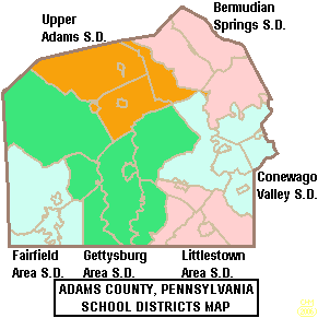
Public school districts
- Bermudian Springs School District – ranked 277th (2015), 350th (2012), 289th (2008)
- Conewago Valley School District – ranked 242nd (2015), 310th (2012), 330th (2008)
- Fairfield Area School District – ranked 221st (2015), 332nd (2012), 410th (2008)
- Gettysburg Area School District – ranked 117th (2015), 180th (2012), 318th (2008)
- Littlestown Area School District – ranked 207th (2015), 293rd (2012), 280th (2008)
- Upper Adams School District – ranked 258th (2015), 272 (2012), 274th (2008)
The 496 school districts of Pennsylvania, that operate high schools, were ranked for student academic achievement as demonstrated by three years of math, reading, writing and science PSSA results by the.[17][18]
Public charter schools
- Gettysburg Montessori Charter School – Gettysburg (K-6)
- Vida Charter School – Gettysburg (K-6)
County residents may also apply to attend any of the Commonwealth's 14 public, cyber charter schools (in 2015) at no additional cost to the parents.[19]
Private schools
As reported by Pennsylvania Department of Education April 2015
- Academy for Media Production - McSherrystown
- Adams County Christian Academy – Gettysburg
- Annunciation BVM School – McSherrystown
- Delone Catholic High School – McSherrystown
- Forest Lane Mennonite School – Gettysburg
- Freedom Christian School – Gettysburg
- Gettysburg SDA Church School – Gettysburg
- Immaculate Conception BVM School – New Oxford
- Independent Baptist Day School - Biglerville
- JIL Christian School – Biglerville
- Littlestown Christian Academy – Littlestown
- Oxford Christian Academy - New Oxford
- Paradise School - Abbottstown
- Sacred Heart School – Hanover
- St Francis Xavier School – Gettysburg
- St James Child Care Center - Gettysburg
- St Joseph Academy Preschool - McSherrystown
Intermediate Unit
Lincoln Intermediate Unit (IU#12) region includes: Adams County, Franklin County and York County. The agency offers school districts, home schooled students and private schools many services including: Special education services, combined purchasing, and instructional technology services. It runs Summer Academy which offers both art and academic strands designed to meet the individual needs of gifted, talented and high achieving students. Additional services include: Curriculum Mapping, Professional Development for school employees, Adult Education, Nonpublic School Services, Business Services, Migrant & ESL (English as a Second Language), Instructional Services, Special Education, Management Services, and Technology Services. It also provides a GED program to adults who want to earn a high school diploma and literacy programs. The Lincoln Intermediate Unit is governed by a 13-member Board of Directors, each a member of a local school board from the 25 school districts. Board members are elected by school directors of all 25 school districts for three-year terms that begin July 1.[20] There are 29 intermediate units in Pennsylvania. They are funded by school districts, state and federal program specific funding and grants. IUs do not have the power to tax.
Libraries
- A R Wentz Library - Gettysburg
- Adams County Historical Society - Gettysburg
- Adams County Law Library - Gettysburg
- East Berlin Community Library - East Berlin
- Fairfield Area Library - Fairfield
- Harbaugh-Thomas Library - Biglerville
- Littlestown Community Library - Littlestown
- Musselman Library - Gettysburg
- New Oxford Area Library - New Oxford
Transportation
Air
There are currently no scheduled commercial flights into Adams County, and travel is limited to general aviation airfields. The nearest airports with regular commercial service are in Hagerstown, Maryland (Hagerstown Regional Airport), Harrisburg, Pennsylvania (Harrisburg International Airport), and Lancaster, Pennsylvania (Lancaster Airport).
Bus
Public bus service in Adams County is available through the Adams County Transit Authority.
Major Highways
Recreation
There is one Pennsylvania state park in Adams County.
- Caledonia State Park is named for an iron furnace that was owned by Thaddeus Stevens. Most of this park is in neighboring Franklin County, but a portion of it extends into Adams. It is just off U.S. Route 30 between Chambersburg and Gettysburg.
Communities
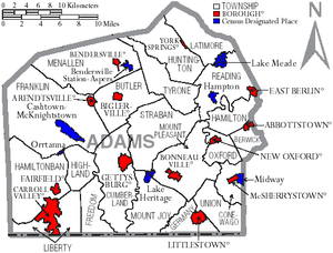
Under Pennsylvania law, there are four types of incorporated municipalities: cities, boroughs, townships, and, in at most two cases, towns. The following boroughs and townships are located in Adams County:
Boroughs
Townships
Census-designated places
Census-designated places are geographical areas designated by the U.S. Census Bureau for the purposes of compiling demographic data, but are not actual jurisdictions under Pennsylvania law. Other unincorporated communities, such as villages, may be listed here as well.
Population ranking
The population ranking of the following table is based on the 2010 census of Adams County.[16]
† county seat
| Rank | City/Town/etc. | Population (2010 Census) | Municipal type | Incorporated |
|---|---|---|---|---|
| 1 | † Gettysburg | 7,620 | Borough | 1806 |
| 2 | Littlestown | 4,434 | Borough | 1864 |
| 3 | Carroll Valley | 3,876 | Borough | 1974 |
| 4 | McSherrystown | 3,038 | Borough | 1882 |
| 5 | Lake Meade | 2,563 | CDP | |
| 6 | Midway | 2,125 | CDP | |
| 7 | Bonneauville | 1,800 | Borough | 1961 |
| 8 | New Oxford | 1,783 | Borough | 1874 |
| 9 | East Berlin | 1,521 | Borough | 1879 |
| 10 | Lake Heritage | 1,333 | CDP | |
| 11 | Biglerville | 1,200 | Borough | 1903 |
| 12 | Abbottstown | 1,011 | Borough | 1835 |
| 13 | Arendtsville | 952 | Borough | 1896 |
| 14 | York Springs | 833 | Borough | 1868 |
| 15 | Heidlersburg | 707 | CDP | |
| 16 | Bendersville | 641 | Borough | 1866 |
| 17 | Hampton | 632 | CDP | |
| 18 | Hunterstown | 547 | CDP | |
| 19 | Fairfield | 507 | Borough | 1896 |
| 20 | Cashtown | 459 | CDP | |
| 21 | Aspers | 350 | CDP | |
| 22 | McKnightstown | 226 | CDP | |
| 23 | Idaville | 177 | CDP | |
| 24 | Orrtanna | 173 | CDP | |
| 25 | Gardners | 150 | CDP | |
| 26 | Table Rock | 62 | CDP | |
| 27 | Floradale | 38 | CDP |
Notable people
- Joel Funk Asper, born in Adams County, United States Congressman from Missouri[21]
- Henry Roelif Brinkerhoff (1787–1844), born in Adams County, United States Congressman[21]
- Dwight D. Eisenhower and Mamie Eisenhower; their retirement home outside Gettysburg is preserved as Eisenhower National Historic Site.
- Erik Harris, football player
- Alpha Jefferson Kynett, (1829–1899), born in Adams County, noted Methodist clergyman and leader of the temperance movement.[21]
- Eddie Plank (1875–1926), Major League Baseball player, pitcher. Third winningest left-handed pitcher of all time. Baseball Hall of Fame induction 1946.
- John Studebaker (1833–1917) was the American co-founder and later executive of what would become the Studebaker Corporation automobile company. He was the third son of the founding Studebaker family and played a key role in the growth of the company during his years as president, from 1868 until his death in 1917.
- David Day (1854–1897), American Lutheran missionary to Liberia.
See also
References
- ↑ "PHMC Historical Markers Search" (Searchable database). Pennsylvania Historical and Museum Commission. Commonwealth of Pennsylvania. Retrieved 2014-01-25.
- 1 2 "State & County QuickFacts". United States Census Bureau. Retrieved November 16, 2013.
- ↑ "Find a County". National Association of Counties. Archived from the original on May 31, 2011. Retrieved June 7, 2011.
- ↑ "2010 Census Gazetteer Files". United States Census Bureau. August 22, 2012. Retrieved March 4, 2015.
- ↑ "County Totals Dataset: Population, Population Change and Estimated Components of Population Change: April 1, 2010 to July 1, 2015". Retrieved July 2, 2016.
- ↑ "U.S. Decennial Census". United States Census Bureau. Archived from the original on May 11, 2015. Retrieved March 4, 2015.
- ↑ "Historical Census Browser". University of Virginia Library. Retrieved March 4, 2015.
- ↑ Forstall, Richard L., ed. (March 27, 1995). "Population of Counties by Decennial Census: 1900 to 1990". United States Census Bureau. Retrieved March 4, 2015.
- ↑ "Census 2000 PHC-T-4. Ranking Tables for Counties: 1990 and 2000" (PDF). United States Census Bureau. April 2, 2001. Retrieved March 4, 2015.
- ↑ "American FactFinder". United States Census Bureau. Archived from the original on September 11, 2013. Retrieved January 31, 2008.
- ↑ Pennsylvania Department of Health, Birth Age County Reports 1990 and 2011, 2011
- ↑ Robert Wood Johnson Foundation, (2016). "Pennsylvania Teen Births 2013,".
- ↑ US Census Bureau (2015). "Poverty Rates by County Small Area Income and Poverty Estimates".
- ↑ Pennsylvania Budget and Policy Center (2012). "Student Poverty Concentration 2012".
- ↑ http://www.whitehouse.gov/omb
- 1 2 http://www.census.gov/2010census/popmap/ipmtext.php?fl=41:42001
- ↑ Pittsburgh Business Times (April 6, 2012). "Statewide School District Rankings".
- ↑ Pittsburgh Business Times (April 10, 2015). "Guide to Pennsylvania Schools Statewide School District Ranking 2015".
- ↑ Pennsylvania Department of Education (2015). "Pennsylvania Charter School".
- ↑ Lincoln Intermediate Unit 12 website accessed April 2010
- 1 2 3 Who Was Who in America, Historical Volume, 1607–1896. Chicago: Marquis Who's Who. 1963.
External links
| Wikimedia Commons has media related to Adams County, Pennsylvania. |
 |
Cumberland County | | ||
| Franklin County | |
York County | ||
| ||||
| | ||||
| Frederick County, Maryland | Carroll County, Maryland |
Municipalities and communities of Adams County, Pennsylvania, United States | ||
|---|---|---|
| Boroughs | | |
| Townships | ||
| CDPs | ||
| Unincorporated communities | ||
| Ghost town | ||
Coordinates: 39°52′N 77°13′W / 39.87°N 77.22°W