Hamilton, Massachusetts
| Hamilton, Massachusetts | ||
|---|---|---|
| Town | ||
|
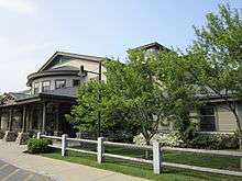
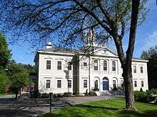
Hamilton Town Hall | ||
| ||
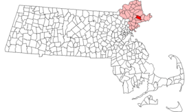 Location in Essex County in Massachusetts | ||
| Coordinates: 42°37′10.95″N 70°51′17.24″W / 42.6197083°N 70.8547889°WCoordinates: 42°37′10.95″N 70°51′17.24″W / 42.6197083°N 70.8547889°W | ||
| Country | United States | |
| State | Massachusetts | |
| County | Essex | |
| Settled | 1638 | |
| Incorporated | 1793 | |
| Government | ||
| • Type | Open town meeting | |
| Area | ||
| • Total | 14.9 sq mi (38.6 km2) | |
| • Land | 14.2 sq mi (36.7 km2) | |
| • Water | 0.7 sq mi (1.9 km2) | |
| Elevation | 49 ft (15 m) | |
| Population (2010) | ||
| • Total | 7,764 | |
| • Density | 520/sq mi (200/km2) | |
| Time zone | Eastern (UTC-5) | |
| • Summer (DST) | Eastern (UTC-4) | |
| ZIP code | 01936/01982 (South Hamilton) | |
| Area code(s) | 351 / 978 | |
| FIPS code | 25-27900 | |
| GNIS feature ID | 0619446 | |
| Website |
www | |


Hamilton is a rural-suburban town in the eastern central portion of Essex County in eastern Massachusetts, United States. At the 2010 census, it had a population of 7,764.[1] Currently the town has no manufacturing industry and no industrially-zoned land.
Its location on the North Shore of Massachusetts provides easy access to the Atlantic seashore with its reservations, beaches and boating. The town includes many historic houses, pastoral landscapes, and old stone walls that accompany winding tree-lined roads. It also has a rich equestrian heritage, which remains strong due to the influence of the many horse farms and of Myopia Hunt Club, which holds frequent equestrian events, including polo most Sunday afternoons. (Myopia also hosts a Thanksgiving Day fox hunt each year that the public may attend.[2]) Thus, the visitor to Hamilton may well share the secondary roads with horse and pony riders.
Hamilton is closely tied to neighboring Wenham, sharing a school system, library, recreation department, commuter rail station and newspaper. In 2010, the community of Hamilton-Wenham was listed among the "Best Places to Live" by Boston Magazine.
Hamilton includes South Hamilton, which is that part of Hamilton that the Postal Service has assigned the zip code 01982. "Hamilton" and "South Hamilton" are indistinguishable from each other except for the difference in zip codes.
History
In June 1638, John Winthrop the Younger, son of the founder of the Massachusetts Bay Colony, bought most of present-day Essex County from Masconomet, chief of the Agawam Indians, for the sum of twenty English pounds. A memorial stone on Sagamore Hill in southeastern Hamilton marks where Mosconomet was buried with his gun and tomahawk around 1658.
Hamilton was first settled in 1638 and was originally a section of Ipswich known as "The Hamlet". The first recorded land grant in the Hamlet was Matthew Whipple's farm, dated 1638. Three years later the new stagecoach road from Boston to Newburyport (Bay Road) was laid out through the Whipple land. Other early settlers of the Hamlet, including the Appletons, Winthrops, Lamsons, and Dodges, were attracted by countryside similar to the English farms and estates they had left behind.
The town was incorporated on June 21, 1793,[3] and named for Alexander Hamilton, whose portrait became the town seal in 1903. With the arrival of the Boston and Maine Railroad in 1839, the population center moved gradually southward toward the depot.
The farm village proved to be an attractive location for Boston groups seeking land for recreation and renewal. A Methodist ministers' association first held a camp meeting at Asbury Grove in 1859. In the 1880s, the Myopia Hunt Club, which had been named in jest for its nearsighted founders, moved from Winchester, Massachusetts, to the Gibney Farm in Hamilton. Beginning as a lawn tennis and baseball club, it turned to polo, the hunt, and golf as members built large summer estates in the area. Myopia donated the site for the General George S. Patton Memorial Park to the town of Hamilton. The park continues to be a recreation center for the town.
In 1921 the Mandell family built the Community House in memory of the eight men in Hamilton and Wenham who died in military service during World War I, including their son, Sam. They commissioned Guy Lowell, a respected architect of Boston and New York, to design the building, and gave the Community House in trust for the use of the residents of both towns. Although in its early days the Community House offered activities such as bowling and a men's smoking room, it now features a wide range of classes and activities for all ages.[4][5][6]
Geography
According to the United States Census Bureau, the town has a total area of 14.9 square miles (38.6 km2), of which 14.2 square miles (36.7 km2) is land and 0.73 square miles (1.9 km2), or 4.89%, is water.[7] Hamilton lies 5 miles (8 km) inland from Massachusetts Bay, and both the eastern and western portion of town are bordered by water, with the Ipswich River to the west and Chebacco Lake and several other small ponds to the east. The highest point in town is found on Blueberry Hill in Bradley Palmer State Park, with an elevation of at least 215 feet (66 m), according to the most recent (2011-2012) USGS 7.5-minute topographical map.[8] Several areas of town are protected, including Myopia Hunt Club and parts of Bradley Palmer State Park, Appleton Farm Sanctuary, and the Ipswich River Wildlife Sanctuary.
Hamilton is bordered by Ipswich to the north, Essex to the east, Manchester-by-the-Sea to the southeast, Wenham to the south, and Topsfield to the west. It is located 8 miles (13 km) north of Salem and 23 miles (37 km) northeast of Boston.
Transportation
- MBTA Commuter Rail provides service from Boston's North Station with the Hamilton/Wenham station on its Newburyport branch of the Newburyport/Rockport Line.
- There are no freeways within town; Route 128 provides the nearest access in Manchester-by-the-Sea. Route 1A passes through the center of town, and Route 22 passes through the eastern corner of town between Wenham and its eastern terminus in Essex.
- The nearest airport is Beverly Municipal Airport, and the nearest national and international air service can be found at Boston's Logan International Airport.
Demographics
| Historical population | ||
|---|---|---|
| Year | Pop. | ±% |
| 1850 | 889 | — |
| 1860 | 789 | −11.2% |
| 1870 | 790 | +0.1% |
| 1880 | 935 | +18.4% |
| 1890 | 961 | +2.8% |
| 1900 | 1,614 | +68.0% |
| 1910 | 1,749 | +8.4% |
| 1920 | 1,631 | −6.7% |
| 1930 | 2,044 | +25.3% |
| 1940 | 2,037 | −0.3% |
| 1950 | 2,764 | +35.7% |
| 1960 | 5,488 | +98.6% |
| 1970 | 6,373 | +16.1% |
| 1980 | 6,960 | +9.2% |
| 1990 | 7,280 | +4.6% |
| 2000 | 8,315 | +14.2% |
| 2010 | 7,764 | −6.6% |
| * = population estimate. Source: United States Census records and Population Estimates Program data.[9][10][11][12][13][14][15][16][17][18] | ||
As of the census[19] of 2000, there were 8,315 people, 2,668 households, and 2,142 families residing in the town. (Update: The population was 8251 in 2009, down less than 100 from the 8,315 of the 2000 census. Based on the total area, both land and water, the density is therefore 553.8 persons per square mile.) As of the 2000 census, there were 2,825 housing units at an average density of 193.5 per square mile (74.7/km²). The racial makeup of the town was 94.19% White, 0.47% African American, 0.17% Native American, 4.26% Asian, 0.05% Pacific Islander, 0.34% from other races, and 0.53% from two or more races. Hispanic or Latino of any race were 0.99% of the population.
There were 2,668 households out of which 66.6% had children under the age of 18 living with them, 71.1% were married couples living together, 7.3% had a female householder with no husband present, and 19.7% were non-families. 15.7% of all households were made up of individuals and 7.0% had someone living alone who was 65 years of age or older. The average household size was 2.87 and the average family size was 3.22.
In the town the population was spread out with 27.4% under the age of 18, 5.9% from 18 to 24, 33.3% from 25 to 44, 23.0% from 45 to 64, and 10.4% who were 65 years of age or older. The median age was 36 years. For every 100 females there were 96.8 males. For every 100 females age 18 and over, there were 95.1 males.
The median income for a household in the town was $72,000, and the median income for a family was $79,886. Males had a median income of $51,776 versus $37,013 for females. The per capita income for the town was $33,222. About 3.4% of families and 5.3% of the population were below the poverty line, including 5.1% of those under age 18 and 3.2% of those age 65 or over.
Education
Hamilton is esteemed for the regional school district it shares with neighboring Wenham, and Hamilton is where the majority of the schools in the Hamilton-Wenham Regional School District are located. Only Buker Elementary School is located outside the town, in Wenham.
At Hamilton-Wenham Regional High School, students' average SAT scores are above the state average (According to numbers released by the state Dept of Education, Hamilton-Wenham Regional High School ranked 27th in the state based on combined total SAT scores for the 2006/2007 school year), and the school regularly sends top students to Ivy League schools. Boston Magazine's 2010 issue showcasing a list of the best public high schools ranked Hamilton-Wenham Regional High School 12th, placing Hamilton-Wenham's public high school in the top 10 percent of the state overall. Hamilton-Wenham also had one of the highest graduation rates, at 96.8 percent. By 2011, Hamilton-Wenham Regional High School had moved up to number nine in Boston Magazine's "Best Schools" list. More recently, Hamilton-Wenham Regional High School ranked 107th (out of 14,000) on Newsweek's 2014 list of "America's Top High Schools"[20] and Hamilton-Wenham Regional High School was ranked the 13th-best public high school in Massachusetts in the 2016 U.S. World & News Report rankings [21] (the same report ranked Hamilton-Wenham 344th nationally.)
According to a September 29, 2010, article in the Hamilton-Wenham Chronicle: "Of the 885 schools in Massachusetts, the Bessie Buker Elementary School ranked second in science on this year's MCAS. The fifth-grade class at the school had 93 percent of its students score advanced and proficient. In addition, all ninth-grade students passed the biology test, with 92 percent scoring advanced and proficient, ranking 20th state-wide. Cutler School scored 21st state-wide with 90 percent of third-graders scoring advanced and proficient in English language arts."[22]
The Pingree School, a private secondary school, is located on the historic Pingree Family Estate in Hamilton.
Hamilton is also home to Gordon-Conwell Theological Seminary, an interdenominational evangelical theological seminary.
Notable people
- Bo Burnham, performance artist
- Michael Carter-Williams, point guard for the Chicago Bulls
- David M. Kelly, Speaker of the Wisconsin State Assembly and a member of the Wisconsin State Senate.
- Chief Masconomet, the last sagamore (chief) of the Agawam tribe of Native Americans. The Agawam tribe once numbered in the tens of thousands and controlled the area now occupied by Essex County. By the early 17th century their numbers were reduced to several hundred by European diseases. Masconomet befriended the white settlers and eventually ceded all the tribe's land to the state in exchange for a small sum of money and protection from enemy tribes. Masconomet died a ward of the state, penniless and without land and was buried on Sagamore Hill in Hamilton in 1658.").[23]
- David Morse, raised in Hamilton, graduate of HWRHS (1971)
- Kevin O'Connor, the TV host for This Old House, lives in a renovated 1894 Queen Anne style house in South Hamilton.
- General George S. Patton (1885-1945), known for his exploits in World War II, resided in Hamilton. This is the reason for Patton Park, a park made famous by the installation of an M4 Sherman full-sized World War II tank on which many children and young adults play. At one point, children were able to play inside the tank until the late 1960s when a fire was set inside. After this the hatches were welded shut.
- General George S. Patton IV (1923-2004). In the years after his 1980 retirement from the Army with the rank of Major General, Patton turned a Hamilton estate owned by his late father into the 250 acres (1.0 km2) Green Meadows Farm, where he named the fields in honor of Vietnam soldiers who died under his command.
- John Ryan Pike, the former drummer of the American indie rock band Ra Ra Riot
- John Shea (archeologist), paleoanthropologist at Stony Brook University
Historic places
- Asbury Grove
- Austin Brown House
- Brown House (Hamilton, Massachusetts)
- Emeline Patch House
- Hamilton Historic District
- Myopia Hunt Club, site of the U.S. Open in 1898, 1901, 1905, and 1908
- Woodberry-Quarrels House
References
- ↑ "Profile of General Population and Housing Characteristics: 2010 Demographic Profile Data (DP-1): Hamilton town, Essex County, Massachusetts". U.S. Census Bureau, American Factfinder. Retrieved September 4, 2012.
- ↑ "Experience The Myopia Club Fox Hunt This Thanksgiving!". Nephotographyguild.com. Retrieved 2015-04-24.
- ↑ The Massachusetts register and United States calendar for the year of our Lord
- ↑ Beattie, Donald W., ed., Hamilton, Massachusetts: "Chronicle of a Country Town"; Hamilton, MA: Town of Hamilton, Massachusetts American Revolution Bicentennial Commission, 1976.
- ↑ Pulsifer, Janice P., Changing Town: Hamilton, Massachusetts 1850-1910; Hamilton, MA: Hamilton Historical Society, 1976.
- ↑ Safford, Daniel E., "Hamilton" in The History of Essex County, Volume II; Philadelphia: J.W. Lewis & Company, 1888.
- ↑ "Geographic Identifiers: 2010 Demographic Profile Data (G001): Hamilton town, Essex County, Massachusetts". U.S. Census Bureau, American Factfinder. Retrieved September 4, 2012.
- ↑ "Georgetown Map". Ims.er.usgs.gov. Retrieved 2015-04-24.
- ↑ "TOTAL POPULATION (P1), 2010 Census Summary File 1". American FactFinder, All County Subdivisions within Massachusetts. United States Census Bureau. 2010.
- ↑ "Massachusetts by Place and County Subdivision - GCT-T1. Population Estimates". United States Census Bureau. Retrieved July 12, 2011.
- ↑ "1990 Census of Population, General Population Characteristics: Massachusetts" (PDF). US Census Bureau. December 1990. Table 76: General Characteristics of Persons, Households, and Families: 1990. 1990 CP-1-23. Retrieved July 12, 2011.
- ↑ "1980 Census of the Population, Number of Inhabitants: Massachusetts" (PDF). US Census Bureau. December 1981. Table 4. Populations of County Subdivisions: 1960 to 1980. PC80-1-A23. Retrieved July 12, 2011.
- ↑ "1950 Census of Population" (PDF). Bureau of the Census. 1952. Section 6, Pages 21-10 and 21-11, Massachusetts Table 6. Population of Counties by Minor Civil Divisions: 1930 to 1950. Retrieved July 12, 2011.
- ↑ "1920 Census of Population" (PDF). Bureau of the Census. Number of Inhabitants, by Counties and Minor Civil Divisions. Pages 21-5 through 21-7. Massachusetts Table 2. Population of Counties by Minor Civil Divisions: 1920, 1910, and 1920. Retrieved July 12, 2011.
- ↑ "1890 Census of the Population" (PDF). Department of the Interior, Census Office. Pages 179 through 182. Massachusetts Table 5. Population of States and Territories by Minor Civil Divisions: 1880 and 1890. Retrieved July 12, 2011.
- ↑ "1870 Census of the Population" (PDF). Department of the Interior, Census Office. 1872. Pages 217 through 220. Table IX. Population of Minor Civil Divisions, &c. Massachusetts. Retrieved July 12, 2011.
- ↑ "1860 Census" (PDF). Department of the Interior, Census Office. 1864. Pages 220 through 226. State of Massachusetts Table No. 3. Populations of Cities, Towns, &c. Retrieved July 12, 2011.
- ↑ "1850 Census" (PDF). Department of the Interior, Census Office. 1854. Pages 338 through 393. Populations of Cities, Towns, &c. Retrieved July 12, 2011.
- ↑ "American FactFinder". United States Census Bureau. Retrieved 2008-01-31.
- ↑ "America's Top High Schools : 2014". Newsweek.com. Retrieved 2015-04-24.
- ↑ http://www.usnews.com/education/best-high-schools/massachusetts/rankings?schooltypepublic=y&schooltypemagnet=y&schooltypecharter=y
- ↑ "Serving our students with excellence". Wicked Local Hamilton. Perinton, New York: GateHouse Media. Sep 29, 2010.
- ↑ "Masconomet: Sachem of the Agawam Tribe". Manchester Historical Society.
Bibliography
- Felt, Joseph Barlow (1834). History of Ipswich, Essex, and Hamilton. Cambridge, Mass.: C. Folsom.
- Dodge, Barnabas (1788). "Hamilton". Essex County 1795. salemdeeds.com.
External links
| Wikivoyage has a travel guide for Hamilton (Massachusetts). |
| Wikimedia Commons has media related to Hamilton, Massachusetts. |
- Town of Hamilton official website
- Anderson, Philader; Brown, A (1831). "Map of the Town of Hamilton". Essex County 1830. Registry of Deeds, Southern Essex District. Retrieved 2 August 2010.
- D.G. Beers & Co. "Hamilton". Essex County 1872. Registry of Deeds, Southern Essex District. Retrieved 2 August 2010.
- 1884 Map of Hamilton. Plate 103 of the Atlas of Essex County Massachusetts, published 1884.
- Old USGS maps of Hamilton
- Historical Resources for Hamilton, at Rootsweb
Boston (capital) | |
| Topics |
|
| Society | |
| Regions | |
| Counties | |
| Cities |
|
Municipalities and communities of Essex County, Massachusetts, United States | ||
|---|---|---|
| Cities |  | |
| Towns | ||
| CDPs | ||
| Other villages | ||