| Site |
Municipality |
Comments |
Image |
Coordinates |
Type |
Ref. |
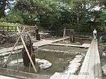
Isehara Hachimandai Stone Age Dwelling Site
伊勢原八幡台石器時代住居跡
Isehara Hachimandai sekki-jidai jūkyo ato |
Isehara |
|
|
35°23′20″N 139°18′31″E / 35.38893842°N 139.30849847°E / 35.38893842; 139.30849847 (Isehara Hachimandai Stone Age Dwelling Site) |
1 |
792 |
Isshōmasu Site
一升桝遺跡
Isshōmasu iseki |
Kamakura |
earthworks beside the road, half a kilometre from Gokuraku-ji[4] |
|
35°18′53″N 139°31′39″E / 35.3146051°N 139.52758283°E / 35.3146051; 139.52758283 (Isshōmasu Site) |
2, 6 |
00003514 |
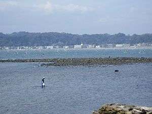
Inamuragasaki
稲村ヶ崎 (新田義貞徒渉伝説地)
Inamuragasaki |
Kamakura |
said to have been the route of Nitta Yoshisada for the Siege of Kamakura (1333) |
|
35°18′07″N 139°31′32″E / 35.30199813°N 139.52549508°E / 35.30199813; 139.52549508 (Inamuragasaki) |
8 |
790 |
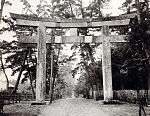
Egara Tenjin Shrine Precinct
荏柄天神社境内
Egara Tenjin-sha keidai |
Kamakura |
submitted for inscription on the UNESCO World Heritage List as one of the Temples, Shrines and other structures of Ancient Kamakura;[5][6] the ICP honden dates to 1316[7] |
|
35°19′33″N 139°33′52″E / 35.32592137°N 139.56436886°E / 35.32592137; 139.56436886 (Egara Tenjin Shrine Precinct) |
3 |
00003454 |
Yōfuku-ji Site
永福寺跡
Yōfukuji ato |
Kamakura |
submitted for inscription on the UNESCO World Heritage List as one of the Temples, Shrines and other structures of Ancient Kamakura[5][6] |
|
35°19′38″N 139°34′08″E / 35.32731805°N 139.56881901°E / 35.32731805; 139.56881901 (Yōfukuji Site) |
3 |
804 |
Engaku-ji Precinct
円覚寺境内
Engakuji keidai |
Kamakura |
submitted for inscription on the UNESCO World Heritage List as one of the Temples, Shrines and other structures of Ancient Kamakura[5][6] |
|
35°20′16″N 139°32′52″E / 35.33790762°N 139.5478108°E / 35.33790762; 139.5478108 (Engakuji Precinct) |
3 |
808 |
Engaku-ji Gardens
円覚寺庭園
Engakuji teien |
Kamakura |
also a Place of Scenic Beauty; submitted for inscription on the UNESCO World Heritage List as one of the Temples, Shrines and other structures of Ancient Kamakura[5][6] |
|
35°20′12″N 139°32′43″E / 35.33677183°N 139.54539308°E / 35.33677183; 139.54539308 (Engakuji Gardens) |
8 |
788 |
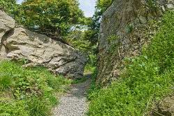
Kewaizaka Pass
仮粧坂
Kehaizaka |
Kamakura |
submitted for inscription on the UNESCO World Heritage List as one of the Temples, Shrines and other structures of Ancient Kamakura[5][6] |
|
35°19′37″N 139°32′44″E / 35.32695051°N 139.54566391°E / 35.32695051; 139.54566391 (Kewaizaka Pass) |
6 |
814 |
Natsushima Shell Mound
夏島貝塚
Natsushima kaizuka |
Yokosuka |
|
|
35°19′21″N 139°38′58″E / 35.32236445°N 139.64956105°E / 35.32236445; 139.64956105 (Natsushima Shell Mound) |
1 |
817 |
Kakuon-ji Precinct
覚園寺境内
Kakuonji keidai |
Kamakura |
submitted for inscription on the UNESCO World Heritage List as one of the Temples, Shrines and other structures of Ancient Kamakura[5][6] |
|
35°19′59″N 139°33′49″E / 35.33298577°N 139.56353313°E / 35.33298577; 139.56353313 (Kakuonji Precinct) |
3 |
809 |
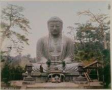
Kamakura Daibutsuden Site
鎌倉大仏殿跡
Kamakura daibutsuden ato |
Kamakura |
submitted for inscription on the UNESCO World Heritage List as one of the Temples, Shrines and other structures of Ancient Kamakura[5][6] |
|
35°19′00″N 139°32′09″E / 35.31673435°N 139.53571041°E / 35.31673435; 139.53571041 (Kamakura Daibutsuden Site) |
3 |
3385 |
Kamegayatsuzaka Pass
亀ヶ谷坂
Kamegayatsuzaka |
Kamakura |
submitted for inscription on the UNESCO World Heritage List as one of the Temples, Shrines and other structures of Ancient Kamakura[5][6] |
|
35°19′51″N 139°33′01″E / 35.33076405°N 139.55038805°E / 35.33076405; 139.55038805 (Kamegayatsuzaka Pass) |
6 |
812 |
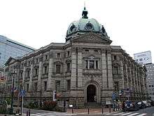
Former Yokohama Specie Bank Head Office
旧横浜正金銀行本店
kyū-Yokohama Shōkin Ginkō honten kaizuka |
Yokohama |
established in 1880, the ICP honkan (main building) dates to 1904 and is used for the Kanagawa Prefectural Museum of Cultural History[8] |
|
35°26′57″N 139°38′11″E / 35.449059°N 139.636307°E / 35.449059; 139.636307 (Former Yokohama Specie Bank Head Office) |
6 |
824 |
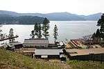
Former Sagami River Pier
旧相模川橋脚
kyū-Sagami-gawa kyōkyaku |
Chigasaki |
|
|
35°19′55″N 139°23′04″E / 35.33198299°N 139.38441004°E / 35.33198299; 139.38441004 (Former Sagami River Pier) |
6 |
777 |
Kobukurozaka Pass
巨福呂坂
Kobukurozaka |
Kamakura |
|
|
35°19′39″N 139°33′16″E / 35.32739418°N 139.55455648°E / 35.32739418; 139.55455648 (Kobukurozaka Pass) |
6 |
813 |
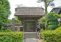
Gokuraku-ji Precinct - Tomb of Ninshō
極楽寺境内・忍性墓
Gokurakuji keidai・Ninshō no haka |
Kamakura |
submitted for inscription on the UNESCO World Heritage List as one of the Temples, Shrines and other structures of Ancient Kamakura[5][6] |
|
35°18′36″N 139°31′44″E / 35.3100966°N 139.52880202°E / 35.3100966; 139.52880202 (Gokurakuji Precinct - Tomb of Ninshō) |
7 |
781 |
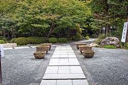
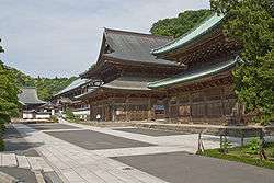
Kenchō-ji Precinct
建長寺境内
Kenchōji keidai |
Kamakura |
submitted for inscription on the UNESCO World Heritage List as one of the Temples, Shrines and other structures of Ancient Kamakura[5][6] |
|
35°19′54″N 139°33′17″E / 35.33160435°N 139.55467388°E / 35.33160435; 139.55467388 (Kenchōji Precinct) |
3 |
805 |
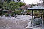
Kenchō-ji Gardens
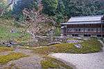
建長寺庭園
Kenchōji teien |
Kamakura |
also a Place of Scenic Beauty; submitted for inscription on the UNESCO World Heritage List as one of the Temples, Shrines and other structures of Ancient Kamakura[5][6] |
|
35°19′56″N 139°33′20″E / 35.33218681°N 139.55554868°E / 35.33218681; 139.55554868 (Kenchōji Gardens) |
8 |
787 |
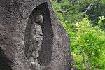
Moto-Hakone Stone Buddhas
元箱根石仏群
Moto-Hakone sekibutsu |
Hakone |
designation includes three gorintō, one dating to 1295, and a hōkyōintō of 1296; the ICP sculptures date from the late C13/early C14[9][10][11] |
|
35°13′02″N 139°02′19″E / 35.21714185°N 139.03863773°E / 35.21714185; 139.03863773 (Moto-Hakone Stone Buddhas) |
3 |
797 |
Goryōgaidai Shell Mound
五領ヶ台貝塚
Goryōgaidai kaizuka |
Hiratsuka |
|
|
35°21′16″N 139°18′02″E / 35.35437008°N 139.300568°E / 35.35437008; 139.300568 (Goryōgaidai Shell Mound) |
1 |
818 |
Grave of William Adams
三浦安針墓
Miura Anjin no haka |
Yokosuka |
|
|
35°16′45″N 139°38′27″E / 35.27911496°N 139.64084299°E / 35.27911496; 139.64084299 (Grave of William Adams) |
7 |
774 |
Santonodai Site
三殿台遺跡
Santonodai iseki |
Yokohama |
|
|
35°25′14″N 139°36′39″E / 35.42065195°N 139.61075656°E / 35.42065195; 139.61075656 (Santonodai Site) |
1 |
802 |
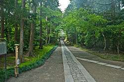
Wakamiya Ōji
若宮大路
Wakamiya Ōji |
Kamakura |
submitted for inscription on the UNESCO World Heritage List as one of the Temples, Shrines and other structures of Ancient Kamakura[5][6] |
|
35°18′58″N 139°33′01″E / 35.31612247°N 139.55027298°E / 35.31612247; 139.55027298 (Wakamiya Ōji) |
3, 6 |
793 |
Jufuku-ji Precinct
寿福寺境内
Jufukuji keidai |
Kamakura |
submitted for inscription on the UNESCO World Heritage List as one of the Temples, Shrines and other structures of Ancient Kamakura[5][6] |
|
35°19′27″N 139°32′57″E / 35.32417515°N 139.54924252°E / 35.32417515; 139.54924252 (Jufukuji Precinct) |
3 |
801 |
Akibayama Kofun Cluster
秋葉山古墳群
Akibayama kofun-gun |
Ebina |
|
|
35°28′12″N 139°24′15″E / 35.47004387°N 139.4041932°E / 35.47004387; 139.4041932 (Akibayama Kofun Cluster) |
1 |
00003453 |
Katsusaka Site
勝坂遺跡
Katsusaka iseki |
Sagamihara |
|
|
35°30′32″N 139°23′18″E / 35.50889722°N 139.38826591°E / 35.50889722; 139.38826591 (Katsusaka Site) |
1 |
819 |
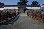
Odawara Castle Site
小田原城跡
Odawara-jō ato |
Odawara |
|
|
35°15′03″N 139°09′13″E / 35.25069544°N 139.1535599°E / 35.25069544; 139.1535599 (Odawara Castle Site) |
2 |
794 |
Shōmyō-ji Precinct
称名寺境内
Shōmyōji keidai |
Yokohama |
submitted for inscription on the UNESCO World Heritage List as one of the Temples, Shrines and other structures of Ancient Kamakura[5][6] |
|
35°20′38″N 139°37′49″E / 35.34401438°N 139.63033998°E / 35.34401438; 139.63033998 (Shōmyōji Precinct) |
3 |
773 |
Jōkōmyō-ji Precinct - Grave of Reizei Tamesuke
浄光明寺境内・冷泉為相墓
Jōkōmyōji keidai・Reizeni Tamesuke haka |
Kamakura |
submitted for inscription on the UNESCO World Heritage List as one of the Temples, Shrines and other structures of Ancient Kamakura[5][6] |
|
35°19′37″N 139°33′05″E / 35.32698816°N 139.55137061°E / 35.32698816; 139.55137061 (Jōkōmyōji Precinct) |
3, 7 |
780 |
Jōchi-ji Precinct
浄智寺境内
Jōchiji keidai |
Kamakura |
|
|
35°20′00″N 139°32′48″E / 35.33345466°N 139.54661145°E / 35.33345466; 139.54661145 (Jōchiji Precinct) |
3 |
800 |
Jōmyō-ji Precinct
浄妙寺境内
Jōmyōji keidai |
Kamakura |
|
|
35°19′21″N 139°34′16″E / 35.32257345°N 139.57111023°E / 35.32257345; 139.57111023 (Jōmyōji Precinct) |
3 |
806 |
Kanzaki Site
神崎遺跡
Kanzaki iseki |
Ayase |
|
|
35°24′37″N 139°24′26″E / 35.41024387°N 139.40715118°E / 35.41024387; 139.40715118 (Kanzaki Site) |
1 |
00003699 |
Zuisen-ji Precinct
瑞泉寺境内
Zuisenji keidai |
Kamakura |
submitted for inscription on the UNESCO World Heritage List as one of the Temples, Shrines and other structures of Ancient Kamakura[5][6] |
|
35°19′21″N 139°34′16″E / 35.32257345°N 139.57111023°E / 35.32257345; 139.57111023 (Zuisenji Precinct) |
3 |
815 |
Suara Stone Age Site
寸沢嵐石器時代遺跡
Suara shisekki-jidai iseki |
Sagamihara |
|
|
35°36′00″N 139°13′24″E / 35.59995902°N 139.22343084°E / 35.59995902; 139.22343084 (Suara Stone Age Site) |
1 |
785 |
Mount Ishigaki
石垣山
Ishigaki-yama |
Odawara |
|
|
35°14′08″N 139°07′39″E / 35.23545028°N 139.12745228°E / 35.23545028; 139.12745228 (Mount Ishigaki) |
2 |
799 |
Kawajiri Stone Age Site
川尻石器時代遺跡
Kawajiri shisekki-jidai iseki |
Sagamihara |
|
|
35°35′30″N 139°18′01″E / 35.5915723°N 139.30018766°E / 35.5915723; 139.30018766 (Kawajiri Stone Age Site) |
1 |
786 |
Sagami Kokubun-ji Site
相模国分寺跡
Sagami Kokubunji ato |
Ebina |
provincial temple of Sagami Province |
|
35°27′16″N 139°23′52″E / 35.45443278°N 139.39780691°E / 35.45443278; 139.39780691 (Sagami Kokubunji Site) |
3 |
771 |
Sagami Kokubunni-ji Site
相模国分尼寺跡
Sagami Kokubunniji ato |
Ebina |
provincial nunnery of Sagami Province |
|
35°27′38″N 139°23′53″E / 35.46047584°N 139.39806854°E / 35.46047584; 139.39806854 (Sagami Kokubunniji Site) |
3 |
825 |
Ōmachi Shakadō Pass Site
大町釈迦堂口遺跡
Ōmachi Shakado-guchi iseki |
Kamakura |
|
|
35°19′02″N 139°33′54″E / 35.31725805°N 139.56498735°E / 35.31725805; 139.56498735 (Ōmachi Shakadō Pass Site) |
3 |
00003681 |
Ōtsuka-Saikachido Site
大塚・歳勝土遺跡
Ōtsuka-Saikachido iseki |
Yokohama |
|
|
35°33′02″N 139°34′50″E / 35.55066428°N 139.58062308°E / 35.55066428; 139.58062308 (Ōtsuka-Saikachido Site) |
1 |
823 |
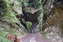
Daibutsu Pass
大仏切通
Daibutsu kiridōshi |
Kamakura |
submitted for inscription on the UNESCO World Heritage List as one of the Temples, Shrines and other structures of Ancient Kamakura[5][6] |
|
35°19′38″N 139°31′59″E / 35.32709408°N 139.53318115°E / 35.32709408; 139.53318115 (Daibutsu Pass) |
6 |
820 |
Asaina Pass
朝夷奈切通
Asaina kiridōshi |
Kamakura |
submitted for inscription on the UNESCO World Heritage List as one of the Temples, Shrines and other structures of Ancient Kamakura[5][6] |
|
35°19′51″N 139°35′28″E / 35.33076405°N 139.59105875°E / 35.33076405; 139.59105875 (Asaina Pass) |
6 |
811 |
Nagaesakurayama Kofun Cluster
長柄桜山古墳群
Nagaesakurayama kofun-gun |
Zushi, Hayama |
|
|
35°17′14″N 139°35′05″E / 35.28711559°N 139.58482271°E / 35.28711559; 139.58482271 (Nagaesakurayama Kofun Cluster) |
1 |
3351 |
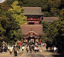
Tsurugaoka Hachiman-gū Precinct
鶴岡八幡宮境内
Tsurugaoka Hachimangū keidai |
Kamakura |
submitted for inscription on the UNESCO World Heritage List as one of the Temples, Shrines and other structures of Ancient Kamakura[5][6] |
|
35°19′31″N 139°33′21″E / 35.32529159°N 139.5559293°E / 35.32529159; 139.5559293 (Tsurugaoka Hachimangū Precinct) |
3 |
807 |
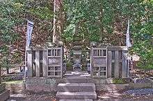
Grave of Uesugi Norikata
伝上杉憲方墓
den-Uesugi Norikata no haka |
Kamakura |
|
|
35°18′34″N 139°31′47″E / 35.30952262°N 139.52962639°E / 35.30952262; 139.52962639 (Grave of Uesugi Norikata) |
7 |
782 |
Tanamukaihara Site
田名向原遺跡
Tanamukaihara iseki |
Sagamihara |
|
|
35°31′46″N 139°21′18″E / 35.52930989°N 139.35507767°E / 35.52930989; 139.35507767 (Tanamukaihara Site) |
1 |
3244 |
Tōshō-ji Site
東勝寺跡
Tōshōji ato |
Kamakura |
submitted for inscription on the UNESCO World Heritage List as one of the Temples, Shrines and other structures of Ancient Kamakura[5][6] |
|
35°19′14″N 139°33′35″E / 35.32065359°N 139.55969649°E / 35.32065359; 139.55969649 (Tōshōji Site) |
2, 3 |
3213 |
Fujisawa Memorial Tower to Friends and Foe
Fujisawa tekimikata kuyōtō |
Fujisawa |
erected to commemorate those who fell in the Uesugi Zenshū Rebellion (上杉禅秀の乱) of Ōei 23 (1416); on the grounds of Shōjōkō-ji (清浄光寺)[12] |
|
35°20′51″N 139°29′19″E / 35.34760627°N 139.48867362°E / 35.34760627; 139.48867362 (Fujisawa Memorial Tower to Friends and Foe) |
3 |
776 |
Grave of Hino Toshimoto
日野俊基墓
Hino Toshimoto no haka |
Kamakura |
|
|
35°19′41″N 139°32′35″E / 35.32816406°N 139.54303228°E / 35.32816406; 139.54303228 (Grave of Hino Toshimoto) |
7 |
779 |
Hakone Barrier Site
箱根関跡
Hakone no seki ato |
Hakone |
|
|
35°11′33″N 139°01′34″E / 35.1923674°N 139.02617866°E / 35.1923674; 139.02617866 (Hakone Barrier Site) |
6 |
772 |
Buppō-ji Site
仏法寺跡
Buppōji ato |
Kamakura |
submitted for inscription on the UNESCO World Heritage List as one of the Temples, Shrines and other structures of Ancient Kamakura[5][6] |
|
35°18′26″N 139°31′52″E / 35.30735767°N 139.53098513°E / 35.30735767; 139.53098513 (Buppōji Site) |
3 |
00003501 |
Hokkedō Site
法華堂跡 (源頼朝墓・北条義時墓)
Hokkedō ato (Minamoto Yoritomo no haka・Hōjō Yoshitoki no haka) |
Kamakura |
designation includes the tombs of Minamoto no Yoritomo and Hōjō Yoshitoki |
|
35°19′33″N 139°33′40″E / 35.32591733°N 139.56099667°E / 35.32591733; 139.56099667 (Hokkedō Site) |
3, 7 |
778 |
Hōjō Clan Tokiwa Residence Site
北条氏常盤亭跡
Hōjō-shi Tokiwa-tei ato |
Kamakura |
submitted for inscription on the UNESCO World Heritage List as one of the Temples, Shrines and other structures of Ancient Kamakura[5][6] |
|
35°19′24″N 139°31′55″E / 35.32340499°N 139.53200341°E / 35.32340499; 139.53200341 (Hōjō Clan Tokiwa Residence Site) |
2 |
821 |
Nagoe Pass
名越切通
Nagoe kiridōshi |
Kamakura |
submitted for inscription on the UNESCO World Heritage List as one of the Temples, Shrines and other structures of Ancient Kamakura[5][6] |
|
35°18′27″N 139°33′53″E / 35.30738381°N 139.56470343°E / 35.30738381; 139.56470343 (Nagoe Pass) |
6 |
803 |
Meigetsu-in Precinct
明月院境内
Meigetsuin keidai |
Kamakura |
|
|
35°20′06″N 139°33′05″E / 35.33504347°N 139.55130101°E / 35.33504347; 139.55130101 (Meigetsuin Precinct) |
3 |
822 |
Wakae Island
和賀江嶋
Wakaenoshima |
Kamakura, Zushi |
submitted for inscription on the UNESCO World Heritage List as one of the Temples, Shrines and other structures of Ancient Kamakura[5][6] |
|
35°18′01″N 139°33′05″E / 35.30028254°N 139.55142955°E / 35.30028254; 139.55142955 (Wakae Island) |
3, 5, 6 |
810 |
Akasaka Site
赤坂遺跡
Akasaka iseki |
Miura |
|
|
35°10′35″N 139°33′05″E / 35.176299°N 139.55142955°E / 35.176299; 139.55142955 (Akasaka Site) |
1 |
|
Old Hakone Road
箱根旧街道
Hakone kyū-kaidō |
Hakone |
stretch of the old Tōkaidō; the designation includes areas of Mishima and Kannami in Shizuoka Prefecture |
|
35°11′36″N 139°01′35″E / 35.19331254°N 139.02647902°E / 35.19331254; 139.02647902 (Old Hakone Road) |
6 |
798 |
Tachibana Kanga Sites
橘樹官衙遺跡群
Tachibana kanga iseki-gun | Kawasaki | | | 35°34′42″N 139°37′09″E / 35.578452°N 139.619204°E / 35.578452; 139.619204 (Tachibana Kanga Sites) | | |
Shimoterao Kanga Sites
下寺尾官衙遺跡群
Shimoterao kanga iseki-gun | Chigasaki | | | 35°21′46″N 139°23′48″E / 35.362666°N 139.396538°E / 35.362666; 139.396538 (Shimoterao Kanga Sites) | | |
Tokyo Bay Fort Sites
東京湾要塞跡
Tōkyō-wan yōsai ato | Yokosuka | designation includes the sites of Sarushima Battery (猿島砲台跡) and Chiyogasaki Battery (千代ヶ崎砲台跡) |  | 35°17′10″N 139°41′38″E / 35.286020°N 139.693995°E / 35.286020; 139.693995 (Tokyo Bay Fort Sites) | | |


.JPG)