Interstate 78 in New York
| ||||
|---|---|---|---|---|
|
Map of New York City with I-78 highlighted in red | ||||
| Route information | ||||
| Maintained by PANYNJ | ||||
| Length: | 0.90 mi[1] (1.45 km) | |||
| Existed: | 1978 – present | |||
| Major junctions | ||||
| West end: |
| |||
| East end: | Canal Street in Lower Manhattan | |||
| Highway system | ||||
| ||||

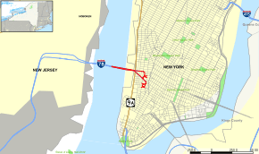
Interstate 78 (I-78) is a part of the Interstate Highway System that runs from Union Township, Lebanon County, Pennsylvania, to New York City. The portion of I-78 within the U.S. state of New York is just 0.90 miles (1.45 km) long as it crosses the Hudson River from New Jersey via the Holland Tunnel and ends at the exit rotary in Lower Manhattan. Therefore, the entire route is maintained by the Port Authority of New York and New Jersey. However, a much longer route was once planned, heading east via the Williamsburg Bridge to the John F. Kennedy International Airport and then north over the Throgs Neck Bridge to I-95 in the Bronx. The parts of this that were built are now New York State Route 878 (NY 878) and I-295.
Route description
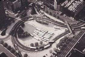
The Holland Tunnel consists of two one-way two-lane tunnels. The entrance plaza to the westbound tunnel is a rectangular block bounded by Broome, Varick, Watts, and Hudson streets, with four entrances feeding into the tunnel from all directions, including one from Canal Street. The westbound portal is to the north, just south of Dominick Street. The exit plaza is in the square double block that previously housed the New York Central Railroad's St. John's Park Terminal, bounded by Laight, Varick, Beach, and Hudson streets. Traffic leaves the tunnel at a portal at the southeast corner of Canal and Hudson streets, and heads southeast along the south line of Canal Street and south along the west line of Varick Street to the northeast corner of the plaza. Five exits, numbered 1 to 5, can be taken from the almost-circular roadway known as the Holland Tunnel Rotary one to each corner and one to the middle of the east side (Varick Street).[2] A pedestrian overpass crosses the entrance to the plaza and exit 5 at the northeast corner, since the entrance from the tunnel cuts Laight Street.[3]
There are four auxiliary routes of I-78, all entering New York, and none connecting with I-78 (because of unbuilt parts of I-78, I-278, and I-478). I-278 begins in Linden, New Jersey, and passes through all five boroughs to end at the Bruckner Interchange in the Bronx; it was proposed to continue west to I-78 in Springfield. The original alignment of I-278 was to end at I-95 in the northeastern Bronx, and is now partially I-895. I-478 is currently the Brooklyn–Battery Tunnel and approaches, connecting I-278 in Brooklyn with the Battery in Manhattan; it was once planned to continue north along the unbuilt Westway to I-78 at the Holland Tunnel. I-478 was originally assigned to the Manhattan Bridge and a branch of the Lower Manhattan Expressway, connecting I-78 in Manhattan with I-278 in Brooklyn. I-678 runs from the John F. Kennedy International Airport in Queens north to the Bruckner Interchange; its original planned south end was at I-278 in northwestern Queens. I-878, signed as part of NY 878, is a short east–west route crossing I-678 at the JFK Airport; it was originally planned to continue west across Brooklyn to I-278 in the southwest part of the borough. The original I-878 is now I-278 east of I-895, and connected I-278 with I-78, I-95, and I-678.
History
Existing segment
When the Interstate numbering was finalized in the late 1950s, the Harrisburg-New York City route, I-78, was assigned to several proposed roads in New York City. It would leave the Holland Tunnel onto the Lower Manhattan Expressway, crossing the East River on the Williamsburg Bridge and following the Bushwick Expressway across Brooklyn to near the John F. Kennedy International Airport. There it would follow the Nassau Expressway along the north boundary of the airport and turn north along the Clearview Expressway through Queens, crossing the East River again on the Throgs Neck Bridge into the Bronx. Finally, I-78 would split into two branches, one heading west along the Cross Bronx Expressway to the Bruckner Interchange and the other heading northwest along the Throgs Neck Expressway to the Bruckner Expressway near the south end of the New England Thruway. Other Interstates junctioned would be I-478 (Manhattan Bridge) in Manhattan, I-278 (Brooklyn–Queens Expressway) in Brooklyn, I-495 (Long Island Expressway) in Queens, and Interstates 95 (Cross Bronx and Bruckner Expressways), 678 (Whitestone Bridge), and 878 (Bruckner Expressway) in the Bronx.[4][5]
When the Throgs Neck Bridge and approaches opened in early 1961, it was signed as I-78. The lack of expressway names on the signs, as specified by federal standards, caused confusion among drivers who knew the highways by their names.[6][7] The Clearview Expressway was completed to its present extent in mid-1963,[8] and a short eastbound-only piece of the Nassau Expressway opened in 1971.[9] Other than the preexisting Holland Tunnel and Williamsburg Bridge, no other portions of I-78 were built.
Canceled segments
Lower Manhattan Expressway
| Lower Manhattan Expressway | |
|---|---|
|
Map of Manhattan with the LOMEX in red | |
| Route information | |
| History: | Proposed in 1941; cancelled in 1962 |
| Major junctions | |
| West end: |
|
| East end: |
|
| Highway system | |
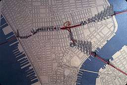
The Lower Manhattan Expressway (LOMEX, also known as the Canal Street Expressway), was a controversial plan for an expressway through Lower Manhattan. The Lower Manhattan Expressway would have begun at the Hudson River on the west side of Manhattan, where it would have connected to I-78 at the eastern portal of the Holland Tunnel. From here, the LOMEX would have proceeded generally southeastward as a ten-lane elevated highway, carrying I-78 over what became SoHo and Little Italy, two areas that would have had portions razed to accommodate the highway. Near the eastern edge of Little Italy, the road would have split into two branches, both leading to bridges over the East River on Manhattan's east side. The main branch would continue southeast as I-78 to the Williamsburg Bridge, while the other would head south to the Manhattan Bridge as I-478. In contrast to the elevated main route, the spur to the Manhattan Bridge would have been mostly depressed, passing under Chrystie Street and the Chrystie Street Connection of the New York City Subway. The I-478 designation was later reassigned to the Brooklyn–Battery Tunnel.
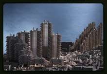
The expressway was originally conceived by Robert Moses in 1941; however, efforts to build the road were delayed until the early 1960s. By 1961, Moses had set in motion two immense federal initiatives, which would have leveled fourteen blocks along Broome Street in Little Italy and what is now SoHo. The highway would have required many historic structures to be condemned and destroyed, and would have displaced an estimated 1,972 families and 804 businesses.[10] Moses's plan, funded as "slum clearance" by Title I of the Housing Act of 1949, also called for multiple blocks to be razed and replaced with upscale high-rises. The plan forced 132 families out of their homes and displaced 1000 small businesses – the result was Washington Square Village.[11]
Members of the affected communities, led by community activist Jane Jacobs, banded together to fight the proposed LOMEX. They held rallies, staged demonstrations and attended hearings to block the project at every step of the process. Jacobs chaired the Joint Committee to Stop the Lower Manhattan Expressway (a.k.a. Joint Emergency Committee to Close Washington Square to Traffic, and other names), which recruited such members as Margaret Mead, Eleanor Roosevelt, Lewis Mumford, Charles Abrams, and William H. Whyte.[12] Papers such as The New York Times were sympathetic to Moses, while the newly created Village Voice covered community rallies and advocated against the expressway.[13] The Committee succeeded in blocking the project. On June 25, 1958, the city closed Washington Square Park to traffic, and the Joint Committee held a ribbon tying (not cutting) ceremony.[14]
On December 11, 1962, there was a stormy six-hour-long special executive session of the New York City Board of Estimate on the second floor of New York City Hall, where city officials voted unanimously to block the planned expressway; Jacobs continued to fight the expressway when plans resurfaced in 1965 and 1968, and she became a local hero for her opposition to the project.[15] Meanwhile, the final plan for the Expressway, which had been approved by the Board of Estimate on September 15, 1960, would have cost over $80,000,000, later rising to $100,000,000. Estimates published in The New York Times in 1962 showed that the $100 million cost would have been covered by $90 million from the federal government, $10 million from the state of New York and $220,000 in city funds.[10] The short section of the Williamsburg Bridge spur directly under Chrystie Street, with its south edge aligned with the north edge of Broome Street, was actually built; the low bid of $1,017,585 was accepted on January 26, 1961, for this 156-foot (48 m) section, and the road was completed in January 1964.
Assemblyman Louis DeSalvio said in a speech:
Except for one old man [Moses], I’ve been unable to find anyone of technical competence who is for this so-called expressway. And this old man is a cantankerous, stubborn old man who has done many things which may have, in their time, been good for New York City. But I think it is time for this stubborn old man to realize that too many of his dreams turn out to be nightmares for the city. And this board must realize that if it does not kill this stupid example of bad city planning, that the stench of it will haunt them and this great city for many years to come.[10]
Robert Moses planned to build other expressways through Manhattan, most of which were never constructed as planned. The Mid-Manhattan Expressway would have been an elevated highway running above 30th Street. The Cross Harlem Expressway would have run at ground level at 125th Street. The Trans-Manhattan Expressway, the only one of Moses' planned Manhattan expressways ever constructed, connected the George Washington Bridge with Moses' Cross Bronx Expressway and was completed in 1962.
A 2015 discovery cites singer Bob Dylan to be part responsible for the eventual cancellation of the LOMEX. In 1963, Dylan was said to have written a song called "Listen, Robert Moses" that protested Moses' plans for a superhighway. The article also notes that the New York Public Library does not have any records containing the song, which few believe Bob Dylan wrote.[16]
Bushwick Expressway
Although the Lower Manhattan Expressway caused the most controversy, the first to be canceled was the Bushwick Expressway, which would have linked the Williamsburg Bridge to the Nassau Expressway via the Bushwick Avenue and Conduit Boulevard/Avenue corridor. The highway would have cut through the Williamsburg, Bushwick and East New York neighborhoods of Brooklyn. The East New York segment was constructed in the East New York section, from Atlantic Avenue to Belt Parkway; this is now Conduit Boulevard/Avenue.
At the urging of Mayor John V. Lindsay, the Cross Brooklyn Expressway, which would connect to the Verrazano-Narrows Bridge, and not provide a link in I-78, was substituted for the Bushwick Expressway in 1967, in order to reduce traffic into Manhattan.[17][18] While campaigning for re-election in 1969, Mayor Lindsay cancelled plans for the Lower Manhattan and Cross Brooklyn Expressways, citing lack of community support.[19][20] All three unbuilt expressways along the path of I-78 were deleted at the state level by Governor Nelson Rockefeller in March 1971.[21] The controversy over the highway coincided with the opposition to the Southwest Expressway in Boston from around 1970, and predated Massachusetts Governor Francis Sargent's 1973 cancellation of expressways in Boston and Cambridge.
Effective January 1, 1970, the New York State Department of Transportation truncated the east end of I-78 to the east end of the Williamsburg Bridge at I-278 in Brooklyn. The Clearview and Throgs Neck Expressways, as well as the eastern part of the Cross Bronx Expressway, became I-295, and the Nassau Expressway became I-878 (now signed as NY 878),[22] though it was still shown as I-78 on maps[23] and signs until 1989. I-878 was also assigned to the unbuilt Cross Brooklyn Expressway, for a total of 15.6 miles (25.1 km) between the Verrazano-Narrows Bridge and John F. Kennedy International Airport.[24][25]
Exit list
These exits are all eastbound-only, numbered sequentially as traffic heads counterclockwise around the tunnel's exit plaza. The westbound entrance plaza is several blocks to the north, and has direct entrances from Hudson Street, Canal Street, Watts Street, and Varick Street.
Holland Tunnel Rotary
The entire route is in the New York City borough of Manhattan (New York County).
| Location | mi[1][26] | km | Exit | Destinations | Notes |
|---|---|---|---|---|---|
| Hudson River | 0.00 | 0.00 | – | New Jersey state line at the river's center | |
| 0.80 | 1.29 | Holland Tunnel (eastbound toll plaza in New Jersey) | |||
| Tribeca | 0.90 | 1.45 | 1 | Via Laight Street; eastern terminus of I-78 | |
| 1.00 | 1.61 | 2 | Hudson Street – Uptown | At the corner of Beach Street | |
| 1.10 | 1.77 | 3 | Brooklyn | Via Walker and Canal Streets to the Manhattan Bridge | |
| 1.10 | 1.77 | 4 | Downtown | Via Varick Street | |
| 1.10 | 1.77 | 5 | Canal Street east | Via Laight Street | |
1.000 mi = 1.609 km; 1.000 km = 0.621 mi
| |||||
Lower Manhattan Expressway
As proposed, I-78 would have four other interchanges as it crossed Manhattan (New York County).[27]
| mi | km | Exit | Destinations | Notes | |
|---|---|---|---|---|---|
| – | Continuation into New Jersey | ||||
| 1 | |||||
| 2 | Sixth Avenue | ||||
| 3 | Continuation into Brooklyn | ||||
| 4 | Delancey Street / Essex Street / Avenue A | ||||
| – | Continuation into Brooklyn | ||||
| 1.000 mi = 1.609 km; 1.000 km = 0.621 mi | |||||
See also
References
- 1 2 "New York County Inventory Listing" (CSV). New York State Department of Transportation. March 2, 2010. Retrieved November 6, 2010.
- ↑ "Holland Tunnel Rotary" (PDF). Ives Architecture Studio. Retrieved 2015-01-24.
- ↑ Google Maps street maps and USGS topographic maps, accessed via ACME Mapper
- ↑ New York City (Map). Rand McNally and Company. 1960. Retrieved April 15, 2010. Note that I-95 is shown on the Hutchinson River Parkway north of the Bruckner Interchange, but the 1955 "Yellow Book" map shows the route on the Bruckner Expressway.
- ↑ Port of New York Authority, A Report on Airport Requirements and Sites in the Metropolitan New Jersey–New York Region (OCLC 2551801), 1961, p. 73
- ↑ Stengren, Bernard (February 4, 1961). "New Road's Signs Create a Mystery". The New York Times. p. 42. Retrieved April 14, 2010.
- ↑ Stengren, Bernard (June 25, 1961). "Debate Stirred by Highway Signs". The New York Times. p. 76. Retrieved April 14, 2010.
- ↑ "First Road Finished for Fair Complex". The New York Times. August 11, 1963. p. 57. Retrieved April 14, 2010.
- ↑ "10.6-Mile Nassau Expressway May Be Completed in 10 Years". The New York Times. March 21, 1971. p. BQ99. Retrieved April 14, 2010.
- 1 2 3 Hunt, Richard P. (December 7, 1962). "Expressway Vote Delayed by City; Final Decision Is Postponed After 6-Hour Hearing". The New York Times. Retrieved August 25, 2008.
Mr. DeSalvio caused a stir early in the hearing by saying that only one old man, whom he described as stubborn and cantankerous, was in favor of the expressway. He did not mention any name.
- ↑ Alexiou 2006, pp. 50–52.
- ↑ Flint 2009, p. 24
- ↑ Flint 2009, pp. 83–84.
- ↑ Flint, Wrestling with Moses (2009), p. 85.
- ↑ Alexiou, Jane Jacobs (2006), p. 117.
- ↑ Gothamist: Did Bob Dylan Write A Protest Song About Robert Moses?
- ↑ "Less Driving Into Manhattan". The New York Times. September 15, 1966. p. 42. Retrieved April 14, 2010.
- ↑ Clarity, James F. (April 26, 1967). "U.S. Aid Is Quietly Pledged For Cross Brooklyn Expressway". The New York Times. p. 35. Retrieved April 14, 2010.
- ↑ Carroll, Maurice (July 17, 1969). "Mayor Drops Plans For Express Roads Across 2 Boroughs". The New York Times. p. 1. Retrieved April 14, 2010.
- ↑ Roberts, Sam (October 7, 1985). "The Legacy of Westway: Lessons from Its Demise". The New York Times. p. A1. Retrieved April 14, 2010.
- ↑ Cliness, Francis X. (March 25, 1971). "Lower Manhattan Road Killed Under State Plan". The New York Times. p. 78. Retrieved April 14, 2010.
- ↑ State of New York Department of Transportation (January 1, 1970). Official Description of Touring Routes in New York State (PDF). Retrieved April 15, 2010.
- ↑ New York and New Jersey Tourgide Map (Map). Cartography by Rand McNally and Company. Gulf Oil Company. 1977. LCCN 76-54616.
- ↑ Report on the Status of the Federal-Aid Highway Program: Hearing, Ninety-First Congress, Second Session, April 15, 1970, pp. 94, 97
- ↑ Federal Highway Administration, Interstate System Route Log & Finder List, January 1971
- ↑ Google (September 10, 2015). "Holland Tunnel Rotary" (Map). Google Maps. Google. Retrieved September 10, 2015.
- ↑ Anderson, Steve. "Lower Manhattan Expressway (I-78 and I-478, unbuilt)". NYCRoads. Retrieved April 29, 2013.
Bibliography
- Alexiou, Alice Sparberg. Jane Jacobs: Urban Visionary (2006) New Brunswick: Rutgers. Toronto: HarperCollins. ISBN 978-0-8135-3792-4
- Flint, Anthony. "Wrestling with Moses: How Jane Jacobs Took On New York's Master Builder and Transformed the American City" (2009) Random House. ISBN 978-1-4000-6674-2
- "State Presses City on Starting Lower Manhattan Expressway", The New York Times, December 26, 1960, page 1.
- "City Link Gets Start", The New York Times, January 27, 1961, page 13.
- Verrazano Link Will Open on S.I.", The New York Times, January 27, 1964, page 25.
External links
| Wikimedia Commons has media related to Interstate 78 in New York. |
- Interstate 78 at Alps' Roads • New York Routes
| Previous state: New Jersey |
New York | Next state: Terminus |
| ||