Jerome County, Idaho
| Jerome County, Idaho | ||
|---|---|---|
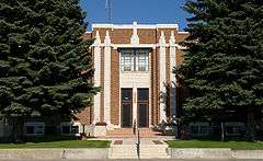 Jerome County Courthouse | ||
| ||
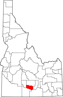 Location in the U.S. state of Idaho | ||
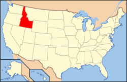 Idaho's location in the U.S. | ||
| Founded | February 8, 1919 | |
| Seat | Jerome | |
| Largest city | Jerome | |
| Area | ||
| • Total | 602 sq mi (1,559 km2) | |
| • Land | 597 sq mi (1,546 km2) | |
| • Water | 5.0 sq mi (13 km2), 0.8% | |
| Population | ||
| • (2010) | 22,374 | |
| • Density | 37/sq mi (14/km²) | |
| Congressional district | 2nd | |
| Time zone | Mountain: UTC-7/-6 | |
| Website |
www | |

Jerome County is a county in the U.S. state of Idaho. As of the 2010 Census the county had a population of 22,374.[1] The county seat and largest city is Jerome.[2] The county was created by the Idaho Legislature on February 8, 1919, by a partition of Lincoln County. It was named after either Jerome Hill, a developer of the North Side Irrigation Project, his son-in-law Jerome Kuhn, or his grandson Jerome Kuhn, Jr.[3]
Jerome County is part of the Twin Falls, ID Micropolitan Statistical Area.
The Minidoka Relocation Camp, one of ten Japanese American internment camps set up during World War II, was located in Jerome County, six miles north of Eden.
Geography
According to the U.S. Census Bureau, the county has a total area of 602 square miles (1,560 km2), of which 597 square miles (1,550 km2) is land and 5.0 square miles (13 km2) (0.8%) is water.[4]
Adjacent counties
- Lincoln County - north
- Gooding County - west
- Twin Falls County - south
- Cassia County - southeast
- Minidoka County - east
Major highways
National protected areas
Demographics
| Historical population | |||
|---|---|---|---|
| Census | Pop. | %± | |
| 1920 | 5,729 | — | |
| 1930 | 8,358 | 45.9% | |
| 1940 | 9,900 | 18.4% | |
| 1950 | 12,080 | 22.0% | |
| 1960 | 11,712 | −3.0% | |
| 1970 | 10,253 | −12.5% | |
| 1980 | 14,840 | 44.7% | |
| 1990 | 15,138 | 2.0% | |
| 2000 | 18,342 | 21.2% | |
| 2010 | 22,374 | 22.0% | |
| Est. 2015 | 22,814 | [5] | 2.0% |
| U.S. Decennial Census[6] 1790-1960[7] 1900-1990[8] 1990-2000[9] 2010-2013[1] | |||
2000 census
As of the census[10] of 2000, there were 18,342 people, 6,298 households, and 4,805 families residing in the county. The population density was 31 people per square mile (12/km²). There were 6,713 housing units at an average density of 11 per square mile (4/km²). The racial makeup of the county was 86.99% White, 0.23% Black or African American, 0.69% Native American, 0.27% Asian, 0.05% Pacific Islander, 9.84% from other races, and 1.94% from two or more races. 17.17% of the population were Hispanic or Latino of any race. 15.4% were of English, 15.3% German, 11.6% American and 6.2% Irish ancestry according to Census 2000.
There were 6,298 households out of which 39.10% had children under the age of 18 living with them, 63.80% were married couples living together, 7.60% had a female householder with no husband present, and 23.70% were non-families. 19.50% of all households were made up of individuals and 8.70% had someone living alone who was 65 years of age or older. The average household size was 2.89 and the average family size was 3.33.
In the county the population was spread out with 31.50% under the age of 18, 8.90% from 18 to 24, 27.10% from 25 to 44, 20.20% from 45 to 64, and 12.30% who were 65 years of age or older. The median age was 33 years. For every 100 females there were 104.60 males. For every 100 females age 18 and over, there were 104.50 males.
The median income for a household in the county was $34,696, and the median income for a family was $39,083. Males had a median income of $28,036 versus $20,194 for females. The per capita income for the county was $15,530. 13.90% of the population and 10.70% of families were below the poverty line. 17.90% of those under the age of 18 and 9.90% of those 65 and older were living below the poverty line.
2010 census
As of the 2010 United States Census, there were 22,374 people, 7,540 households, and 5,656 families residing in the county.[11] The population density was 37.5 inhabitants per square mile (14.5/km2). There were 8,101 housing units at an average density of 13.6 per square mile (5.3/km2).[12] The racial makeup of the county was 80.0% white, 1.3% American Indian, 0.3% black or African American, 0.3% Asian, 0.1% Pacific islander, 15.8% from other races, and 2.1% from two or more races. Those of Hispanic or Latino origin made up 31.0% of the population.[11] In terms of ancestry, 16.7% were German, 11.4% were English, 8.8% were American, and 7.0% were Irish.[13]
Of the 7,540 households, 42.5% had children under the age of 18 living with them, 58.7% were married couples living together, 9.6% had a female householder with no husband present, 25.0% were non-families, and 20.3% of all households were made up of individuals. The average household size was 2.95 and the average family size was 3.39. The median age was 31.7 years.[11]
The median income for a household in the county was $39,188 and the median income for a family was $45,947. Males had a median income of $30,889 versus $23,383 for females. The per capita income for the county was $16,947. About 12.0% of families and 15.5% of the population were below the poverty line, including 23.1% of those under age 18 and 7.6% of those age 65 or over.[14]
Communities
Cities
Unincorporated community
See also
References
- 1 2 "State & County QuickFacts". United States Census Bureau. Retrieved June 30, 2014.
- ↑ "Find a County". National Association of Counties. Retrieved 2011-06-07.
- ↑ Idaho.gov - Jerome County accessed 2009-05-29
- ↑ "US Gazetteer files: 2010, 2000, and 1990". United States Census Bureau. 2011-02-12. Retrieved 2011-04-23.
- ↑ "County Totals Dataset: Population, Population Change and Estimated Components of Population Change: April 1, 2010 to July 1, 2015". Retrieved July 2, 2016.
- ↑ "U.S. Decennial Census". United States Census Bureau. Retrieved June 30, 2014.
- ↑ "Historical Census Browser". University of Virginia Library. Retrieved June 30, 2014.
- ↑ "Population of Counties by Decennial Census: 1900 to 1990". United States Census Bureau. Retrieved June 30, 2014.
- ↑ "Census 2000 PHC-T-4. Ranking Tables for Counties: 1990 and 2000" (PDF). United States Census Bureau. Retrieved June 30, 2014.
- ↑ "American FactFinder". United States Census Bureau. Retrieved 2008-01-31.
- 1 2 3 "DP-1 Profile of General Population and Housing Characteristics: 2010 Demographic Profile Data". United States Census Bureau. Retrieved 2016-01-09.
- ↑ "Population, Housing Units, Area, and Density: 2010 - County". United States Census Bureau. Retrieved 2016-01-09.
- ↑ "DP02 SELECTED SOCIAL CHARACTERISTICS IN THE UNITED STATES – 2006-2010 American Community Survey 5-Year Estimates". United States Census Bureau. Retrieved 2016-01-09.
- ↑ "DP03 SELECTED ECONOMIC CHARACTERISTICS – 2006-2010 American Community Survey 5-Year Estimates". United States Census Bureau. Retrieved 2016-01-09.
External links
 |
Lincoln County | | ||
| Gooding County | |
Minidoka County | ||
| ||||
| | ||||
| Twin Falls County | Cassia County |
Municipalities and communities of Jerome County, Idaho, United States | ||
|---|---|---|
| Cities | ||
| Unincorporated community | ||
Coordinates: 42°41′N 114°16′W / 42.69°N 114.26°W