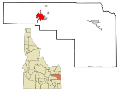
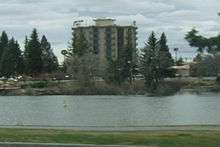
Idaho Falls, Idaho
| Idaho Falls | ||
|---|---|---|
| City | ||
 | ||
| ||
 | ||
 Idaho Falls Location in the United States | ||
| Coordinates: 43°30′N 112°2′W / 43.500°N 112.033°WCoordinates: 43°30′N 112°2′W / 43.500°N 112.033°W | ||
| Country | United States | |
| State | Idaho | |
| County | Bonneville | |
| Founded | 1864 | |
| Incorporated | 1891 | |
| Government | ||
| • Mayor | Rebecca Casper | |
| Area[1] | ||
| • City | 22.80 sq mi (59.05 km2) | |
| • Land | 22.35 sq mi (57.89 km2) | |
| • Water | 0.45 sq mi (1.17 km2) | |
| Elevation | 4,705 ft (1,434 m) | |
| Population (2010)[2] | ||
| • City | 56,813 | |
| • Estimate (2014) | 58,691 | |
| • Density | 2,542.0/sq mi (981.5/km2) | |
| • Metro | 136,108 | |
| Time zone | Mountain (UTC-7) | |
| • Summer (DST) | Mountain (UTC-6) | |
| Area code(s) | 208 | |
| FIPS code | 16-39700 | |
| GNIS feature ID | 0396684 | |
| Website |
www | |
Idaho Falls is a city in and the county seat of Bonneville County, Idaho, United States, and is the largest city in Eastern Idaho.[3] As of the 2010 census, the population of Idaho Falls was 56,813, with a metro population of 136,108.[4] As of 2013, the population was estimated at 58,292.[5]
Idaho Falls is the principal city of the Idaho Falls, Idaho Metropolitan Statistical Area and the Idaho Falls-Blackfoot, Idaho Combined Statistical Area and is the state's largest city outside the Boise metropolitan area and is the third-largest metro area behind Boise City-Nampa and Coeur d'Alene, which is adjacent to the larger Spokane metropolitan area.
Idaho Falls serves as a hub to all of eastern Idaho and much of western Wyoming. Due to its relative economic vitality, high quality of life, and proximity to world-class outdoor recreation, it is often featured in various publications' lists of "best places to live." The area is served by the Idaho Falls Regional Airport and is home to the Idaho Falls Chukars minor league baseball team, and the Idaho Mustangs, a semi-professional football team that plays in the Rocky Mountain Football League.
History

Montana Trail origins
What became Idaho Falls was the site of Taylor’s Crossing on the Montana Trail which was a timber frame bridge built across the Snake River. The 1865 bridge was built by Matt Taylor who was a Montana Trail freighter who built a toll bridge across a narrow black basaltic gorge of the river that succeeded a ferry seven miles upstream by several years.[6] Taylor’s bridge served the new tide of westward migration and travel in the region that followed the military suppression of Shoshone resistance at the Bear River Massacre near Preston, Idaho in 1863. The bridge improved travel for settlers moving north and west and also for miners, freighters, and others seeking riches in the gold fields of Idaho and Montana and especially the boom towns of Bannack and Virginia City in western Montana.
Eagle Rock
Mail service postmarks indicate that by 1866 the emerging town had become known as Eagle Rock. The name was derived from an isolated basalt island in the Snake River, 7 miles (11 km) upstream at 43°36.112′N 112°3.528′W / 43.601867°N 112.058800°W in the Snake River that was the nesting site for approximately twenty eagles. Previous to Taylor's bridge, in 1864, Harry Rickets built and operated a ferry at this location[6][7] and so this area of crossing at the Snake River was already known as Eagle Rock to those who did business or that traveled on the Montana Trail. A private bank (the fourth in Idaho), a small hotel, a livery stable, and an eating house also developed at the bridge in 1865 along with the post office and a stage station.
There had been a few cattle and sheep ranchers in the area for years. In 1874 water rights were established on nearby Willow Creek and the first grain harvested. Settlement was sparse and consisted of only a couple of families and small irrigation ditches. The first child of European descent was born at Eagle Rock being delivered in 1874.
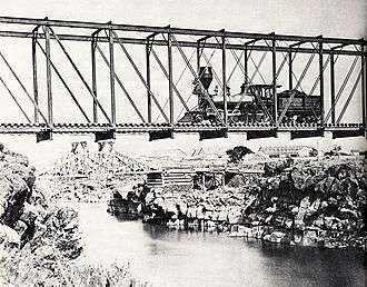
The winds of change arrived in the form of the Utah and Northern Railway (U&NR) that came north from Utah through Eagle Rock and crossed the Snake River at the same narrow gorge as the wooden bridge. The U&NR was building its road to the large new copper mines at Butte, Montana and had the backing of robber baron Jay Gould as Union Pacific Railroad had purchased the U&NR a few years prior.[8] Grading crews reached Eagle Rock in late 1878 and by early 1879 a wild camp-town with dozens of tents and shanties moved to Eagle Rock with the typical collection of saloons, dancehalls, and gambling halls. The railroad company had 16 locomotives and 300 train cars working between Logan, Utah at the once quiet stage stop. A new iron railroad bridge was fabricated in Athens, Pennsylvania at a cost of $30,000 and was shipped, by rail, to the site and erected in April and May 1879.[9] The bridge was 800 feet (240 m) long and in two spans with an island in the center. The camp-town moved on but Eagle Rock, the little town at the wooden bridge, now had regular train service and was the site of several of the railroad’s buildings, shops, and facilities which were expanding and completely transforming the town.
As soon as the railroad came through settlers began homesteading the Upper Snake River Valley. The first of the new settlers carved out homesteads to the north at Egin (near present-day Parker) and at Pooles Island (near present-day Menan).[10] Large scale settlement ensued and in a decade there appeared roads, bridges, dams as well as irrigation canals which brought most of the Upper Snake River Valley under cultivation. In 1887, following the construction of the Oregon Short Line, most of the railroad facilities were removed to Pocatello where the new line branched off the U&NR but Eagle Rock was fast becoming the commercial center of an agricultural empire.
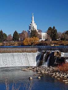
In 1891 the town voted to change its name to Idaho Falls, in reference to the rapids that existed below the bridge. Some years later, the construction of a retaining wall for a hydroelectric power plant enhanced the rapids into falls. In 1895 the largest irrigation canal in the world at that time, the Great Feeder, began diverting water from the Snake River and aided in converting tens of thousands of acres of desert into green farmland in the vicinity of Idaho Falls. The area grew sugar beets, potatoes, peas, grains, and alfalfa and became one of the most productive regions of the United States.
Nuclear reactors
In 1949, the Atomic Energy Commission opened the National Reactor Testing Station in the desert west of the city, and on Dec. 20, 1951, a nuclear reactor produced useful electricity for the first time in history. There have been more than 50 unique nuclear reactors built at the facility for testing. All but three are shut down now.
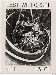
The site was the scene of the only fatal nuclear reactor incident in U.S. history on the night of January 3, 1961. The event occurred at an experimental U.S. Army reactor plant known as the Argonne Low Power Reactor, which the Army called the Stationary Low-Power Reactor Number One (SL-1) once built. Due to poor design and maintenance procedures, a single control rod was manually pulled out too far from the reactor, causing the reactor to become prompt critical, and leading to a destructive power excursion. Three military, trained men had been working inside the reactor room when a mistake was made while reattaching a control rod to its motor assembly.[11] With the central control rod nearly fully extended, the nuclear reactor rated at 3 MW rapidly increased power to 20 GW; this rapidly boiled the water inside the core.[12][13] As the steam expanded, a pressure wave of water forcefully struck the top of the reactor vessel upon which 2 of the men stood. The explosion was so severe that the reactor vessel was propelled 9 feet into the air, striking the ceiling before settling back into its original position.[14] One man was killed instantly as he was impaled by a shield plug and lodged into the ceiling.[11] The other men died from their injuries within hours. The three men were buried in lead coffins, and that entire section of the site was buried.[14][15][16] The core meltdown caused no damage to the area, although some radioactive fission products were released to the atmosphere. While nuclear reactors like SL-1 were predicted to have lower total costs than conventional systems, the Army program to build and use reactors of this kind was scrapped due to the higher initial procurement costs of nuclear reactors.
The Idaho National Laboratory (INL), as it is now known, remains a major economic engine for the city of Idaho Falls, employing more than 8,000 people and functioning as an internationally renowned research center. INL operates and manages the world-famous Advanced Test Reactor (ATR).
Economy
Idaho Falls serves as a regional hub for health care, travel and business in eastern Idaho.
The community's economy was mostly agriculturally focused until the opening of the National Reactor Testing Station in the desert west of Idaho Falls in 1949. The city subsequently became largely dependent on high-income jobs from the Idaho National Laboratory (INL), known locally simply as "The Site." The laboratory made several cutbacks in 1993. Since then the town has added call centers, a growing retail, entertainment, and restaurant sector, and a regional medical center.
Idaho Falls was named by Business Week on the 2010 list of "Best Places to Raise Kids".[17] Forbes.com selected Idaho Falls as one of the "2010 Best Small Places for Business & Careers".[18] Money.CNN.com included Idaho Falls as one of their "Top 100 Cities in 2010".[19]
Idaho Falls has become a regional business hub. It hosts the headquarters of the United Potato Growers of Idaho and District 7 of the Idaho Department of Health and Welfare. It is the home to several small to medium-sized national corporations such as North Wind, Inc., Press-A-Print, and multi-level marketing company Melaleuca, Inc.[20]
The median home price in Idaho Falls was $224,800 in January 2007.[21]
Idaho Falls, Idaho / U.S. average:[21]
- Area population 122,995 / 647,500
- Median home price $224,800 / $235,000
- Cost-of-living index 99.8 / 100.0
- Unemployment rate 2.7% / 4.6%
- Job growth—5 years 18.84% / 4.90%
- Job growth—1 year 2.74% / 1.66%
- Median household income $47,719 / $46,326
Culture
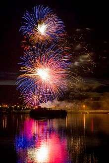
Idaho Falls has established itself as a regional cultural destination. The Willard Art Center, The Colonial Theatre and Civic Auditorium[23] are home to year-round, diverse musical concerts, plays, and events. The greenbelt along the Snake River hosts many community events, such as the Melaleuca Freedom Celebration (on the Fourth of July),[24] the Roaring Youth Jam, and the Farmers' Market.
The Museum of Idaho[25] is a regional attraction which showcases local artifacts and history. It also brings in major traveling exhibits such as dinosaur bones, Gutenberg Bibles, Titanic remnants, and "Bodies: the Exhibition." Idaho Falls is the first city of its size to house the popular attraction.
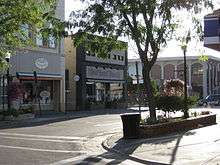
Downtown Idaho Falls once struggled as the city expanded eastward, but it has been revitalized in recent years due to the efforts of local business owners, the City of Idaho Falls, and other organizations such as the Downtown Development Corporation[26] and the Idaho Falls Chamber of Commerce. Today, it is home to a handful of locally owned shops, stores, restaurants, galleries, theaters, and future revitalization efforts.
The city attracts many tourists visiting nearby Yellowstone and Grand Teton National Parks, Jackson Hole, and the world-class fishing on the Snake River. Due to its proximity to so many outdoor destinations, Idaho Falls was recently named to National Geographic's list of "100 Best Adventure Towns".[27]
Greenbelt
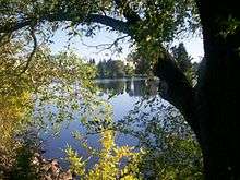
Idaho Falls has an extensive greenbelt, or riverbelt, along miles of the Snake River, which flows through the center of the city. It is maintained by the City of Idaho Falls, and often receives donations and grants which allow for occasional expansion.
The Idaho Falls Redevelopment Agency with the approval of former mayor Jared Fuhriman expanded the greenbelt. This expansion increased the land that was used as well as adding additional parking at the river. This expansion added in a roundabout which improved traffic flow in the city around the greenbelt and the Idaho Falls Temple.
Neighborhoods
Notable Idaho Falls neighborhoods include:
- Historic Downtown - Downtown lies along the east side of the river between Memorial Drive (on the greenbelt) and Yellowstone Avenue. More eateries, wineries, shops, and art centers are popping up downtown each year. Many community events occur in and around downtown, particularly concerts, art shows, the renowned Fourth of July fireworks celebration, and a farmers' market on Saturday mornings.
- The Numbered Streets - The numbered streets area was the first planned neighborhood in Idaho Falls. The tree-lined streets run west and east between South Boulevard and Holmes Avenue. Traffic on the odd-numbered streets travels east, and west on the even-numbered streets. This area has recently become a desirable location because of the re-development of nearby Historic Downtown. Kate Curley Park is located in the neighborhood, as is the Wesley W. Deist Aquatic Center, and the Eleventh Street Historic District.
- West Side - Across the Snake River to the west, this area has more of a small-town feel, as it lacks the congestion and activity of the east side. The north portion of the west side was established in the 1960s with homes, and saw more overall growth up until the '80s. Today, the west side is expected to boom in population and commercial activity due to major developments such as Taylor Crossing and Snake River Landing, as well as the Areva uranium enrichment facility planned west of the city. The west side also houses Idaho Falls Regional Airport as well as the entirety of I-15's brief jaunt through the city.
Geography and climate
The elevation of Idaho Falls is 4,700 feet (1,400 m).
According to the United States Census Bureau, the city has a total area of 22.80 square miles (59.05 km2), of which, 22.35 square miles (57.89 km2) is land and 0.45 square miles (1.17 km2) is water.[1]
Tornadoes are rare, though a F2 tornado did hit the Idaho Falls area on April 7, 1978 causing between 500,000 and 5 million dollars in damage.[28]
| Climate data for Idaho Falls, Idaho | |||||||||||||
|---|---|---|---|---|---|---|---|---|---|---|---|---|---|
| Month | Jan | Feb | Mar | Apr | May | Jun | Jul | Aug | Sep | Oct | Nov | Dec | Year |
| Record high °F (°C) | 57 (14) |
63 (17) |
75 (24) |
85 (29) |
95 (35) |
100 (38) |
104 (40) |
100 (38) |
95 (35) |
87 (31) |
73 (23) |
60 (16) |
104 (40) |
| Average high °F (°C) | 29.7 (−1.3) |
36.6 (2.6) |
47.6 (8.7) |
58.7 (14.8) |
67.9 (19.9) |
77.8 (25.4) |
86.0 (30) |
85.8 (29.9) |
75.1 (23.9) |
61.4 (16.3) |
43.0 (6.1) |
31.3 (−0.4) |
58.41 (14.66) |
| Average low °F (°C) | 12.5 (−10.8) |
16.8 (−8.4) |
24.8 (−4) |
31.3 (−0.4) |
38.7 (3.7) |
46.0 (7.8) |
51.4 (10.8) |
49.9 (9.9) |
41.3 (5.2) |
32.2 (0.1) |
23.2 (−4.9) |
13.4 (−10.3) |
31.79 (−0.11) |
| Record low °F (°C) | −29 (−34) |
−34 (−37) |
−15 (−26) |
9 (−13) |
20 (−7) |
28 (−2) |
34 (1) |
31 (−1) |
18 (−8) |
7 (−14) |
−12 (−24) |
−29 (−34) |
−34 (−37) |
| Average precipitation inches (mm) | 1.25 (31.8) |
1.01 (25.7) |
1.33 (33.8) |
1.27 (32.3) |
2.01 (51.1) |
1.18 (30) |
0.74 (18.8) |
0.93 (23.6) |
0.94 (23.9) |
1.12 (28.4) |
1.17 (29.7) |
1.26 (32) |
14.21 (361.1) |
| Source #1: NOAA (normals, 1971–2000)[29] | |||||||||||||
| Source #2: The Weather Channel (Records)[30] | |||||||||||||
Demographics
| Historical population | |||
|---|---|---|---|
| Census | Pop. | %± | |
| 1900 | 1,262 | — | |
| 1910 | 4,827 | 282.5% | |
| 1920 | 8,064 | 67.1% | |
| 1930 | 9,429 | 16.9% | |
| 1940 | 15,024 | 59.3% | |
| 1950 | 19,218 | 27.9% | |
| 1960 | 33,161 | 72.6% | |
| 1970 | 35,776 | 7.9% | |
| 1980 | 39,739 | 11.1% | |
| 1990 | 43,929 | 10.5% | |
| 2000 | 50,730 | 15.5% | |
| 2010 | 56,813 | 12.0% | |
| Est. 2015 | 59,184 | [31] | 4.2% |
In a 2008 estimate, it was found that Idaho Falls had a violent crime rate of 0.9 times the national average and a property crime rate of 0.97 times the national average.
2010 census
As of the census[2] of 2010, there were 56,813 people, 21,203 households, and 14,510 families residing in the city. The population density was 2,542.0 inhabitants per square mile (981.5/km2). There were 22,977 housing units at an average density of 1,028.1 per square mile (397.0/km2). The racial makeup of the city was 89.3% White, 0.7% African American, 1.0% Native American, 1.0% Asian, 0.1% Pacific Islander, 5.6% from other races, and 2.3% from two or more races. Hispanic or Latino of any race were 12.9% of the population.
There were 21,203 households of which 37.1% had children under the age of 18 living with them, 52.4% were married couples living together, 11.3% had a female householder with no husband present, 4.7% had a male householder with no wife present, and 31.6% were non-families. 26.5% of all households were made up of individuals and 9.7% had someone living alone who was 65 years of age or older. The average household size was 2.63 and the average family size was 3.20.
The median age in the city was 32.2 years. 29.3% of residents were under the age of 18; 9.2% were between the ages of 18 and 24; 26.5% were from 25 to 44; 23.4% were from 45 to 64; and 11.8% were 65 years of age or older. The gender makeup of the city was 49.5% male and 50.5% female.
2000 census
The 2000 census[33] reported there were 50,730 people, 18,793 households, and 13,173 families residing in the city, though MSN real estate reports an area population of 110,220. The population density was 2,972.2 people per square mile (1,147.4/km²). There were 19,771 housing units at an average density of 1,158.4 per square mile (447.2/km²). The racial makeup of the city was 92.09% White, 0.62% African American, 0.76% Native American, 1.05% Asian, 0.06% Pacific Islander, 3.81% from other races, and 1.61% from two or more races. Hispanic or Latino of any race were 7.18% of the population.
There were 18,793 households out of which 37.5% had children under the age of 18 living with them, 56.5% were married couples living together, 10.2% had a female householder with no husband present, and 29.9% were non-families. 25.3% of all households were made up of individuals and 9.1% had someone living alone who was 65 years of age or older. The average household size was 2.65 and the average family size was 3.21.
In the city the population was spread out with 30.3% under the age of 18, 10.1% from 18 to 24, 27.6% from 25 to 44, 20.9% from 45 to 64, and 11.1% who were 65 years of age or older. The median age was 32 years. For every 100 females there were 97.9 males. For every 100 females age 18 and over, there were 94.8 males.
The top five ethnic groups in Idaho Falls are:[34]
- English - 22%
- German - 16%
- Irish - 7%
- Mexican - 5%
- Swedish - 4%
The median income for a household in the city was $40,512, and the median income for a family was $47,431. Males had a median income of $39,082 versus $23,001 for females. The per capita income for the city was $18,857. About 7.8% of families and 10.9% of the population were below the poverty line, including 12.7% of those under age 18 and 6.3% of those age 65 or over.
Higher education
Idaho Falls is home to a few higher education options, including Eastern Idaho Technical College, established in 1969 as a vocational-technical college. Stevens-Henager College and University of Phoenix have also opened local resource centers in order to aid students in online degree programs.
A unique satellite campus called University Place features dual enrollment for students in both Pocatello-based Idaho State University and Moscow-based University of Idaho. Students generally earn core classes at University Place and then transfer to ISU's or UI's main campus to finish their degrees. However, a few dozen degree programs, both undergraduate and graduate, are fully offered at University Place. The campus also boasts high-tech facilities such as the Center for Advanced Energy Studies (CAES). CAES is run by a partnership of Idaho's three research universities (UI, ISU, Boise State) and Idaho National Laboratory (INL).
Despite the current lack of a traditional college, a relatively high percentage of residents hold advanced degrees and perform significant research, largely thanks to the presence of INL.
Primary and secondary education
Idaho Falls is served by the Idaho Falls School District #91 and Bonneville Joint School District #93. District #91 covers the majority of urban Idaho Falls and a small portion of Bonneville county west of the city. District #93 covers minimal parts of eastern Idaho Falls and the remainder of Bonneville County with the exception of some remote areas that have independent elementary districts. All junior high and high school students are transported in to District 93 secondary schools.
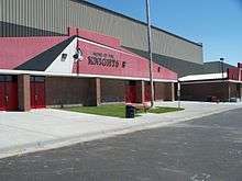
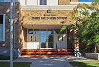
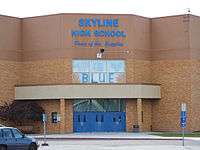
Idaho Falls is home to a total of five major public high schools, two alternative high schools, one magnet high school, four middle schools, and 25 elementary schools.
High schools

- Thunder Ridge High School (scheduled to open in fall 2018)
Magnet high schools
- Compass Academy[35]
Alternative high schools
- Emerson Alternative High School
- Lincoln Alternative High School
Middle schools
- Eagle Rock Middle School
- Rocky Mountain Middle School
- Sandcreek Middle School
- Taylorview Middle School
Elementary schools
- A.H. Bush Elementary School
- Ammon Elementary School
- Bridgewater Elementary School
- Cloverdale Elementary School
- Discovery Elementary School
- Dora Erickson Elementary School
- Edgemont Elementary School
- Ethel Boyes Elementary School
- Fairview Elementary School
- Falls Valley Elementary School
- Hawthorne Elementary School
- Hillview Elementary School
- Iona Elementary School
- Linden Park Elementary School
- Longfellow Elementary School
- Mountain Valley Elementary School
- Rimrock Elementary School
- Summit Hills Elementary School
- Sunnyside Elementary School
- Temple View Elementary School
- Theresa Bunker Elementary School
- Tiebreaker Elementary School
- Ucon Elementary School
- Westside Elementary School
- Woodland Hills Elementary School
The Idaho Falls area also offers three public charter school options: Taylor's Crossing Public Charter School, White Pine Charter School, and Monticello Montessori Public Charter School.
Additionally, numerous private schools provide educational opportunities at varying grade levels.
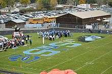
Each fall, the varsity football teams of Idaho Falls and Skyline High Schools compete in a rival football game called the Emotion Bowl, at Idaho Falls' Ravsten Stadium, which is shared by the two schools. The winning team and its fans traditionally paint the goalposts of the stadium in their school colors (orange for Idaho Falls High School, and blue for Skyline High School) after each Emotion Bowl.[36] Bonneville High School and Hillcrest High School participate in a similar event, known as the Civil War.
Notable people
- Chandler Brossard - beat novelist, author of Who Walk in Darkness
- Gregory C. Carr - telecommunications entrepreneur and philanthropist; head of Gorongosa National Park restoration in Mozambique
- Steven E. Carr - only American ever elected to Standing Commission of International Red Cross and Red Crescent Movement, organization's highest governing body worldwide
- Barzilla W. Clark, Governor of Idaho 1937-1939. Mayor of Idaho Falls 1913–15, 1926–36
- Mike Crapo - U.S. Senator (R-ID), serving since 1998
- Dame Darcy - avant-garde cartoonist and author of Meatcake
- Jared Gold - fashion designer, featured on America's Next Top Model
- Gregg Hale - guitar player for multi-platinum selling British band Spiritualized
- Michael Jon Hand - CIA agent, arms dealer, drug dealer and international fugitive; co-founder of the defunct Nugan Hand Bank
- Mary Kornman - actress, best known for Our Gang comedies
- Rachel Martin - NPR journalist
- Yo Murphy - former CFL/NFL wide receiver; played at Idaho Falls High School
- Brandi Sherwood - Miss Idaho Teen USA 1989, Miss Teen USA 1989, Miss Idaho USA 1997, Miss USA 1997 (succeeded)
- Patrick Skelton - actor, best known for All My Children[37][38]
- John L. Smith - head football coach at Michigan State, Louisville, Utah State, Idaho, and Arkansas
- Frank L. VanderSloot - businessman, owner of Melaleuca Inc., a home-goods/health-product marketing company; national finance co-chair for Mitt Romney's 2012 presidential campaign
Sister city
Idaho Falls has a sister city, as designated by Sister Cities International:
Gallery
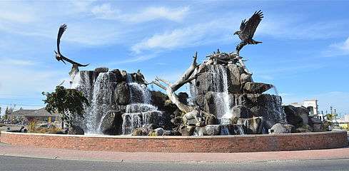 Fountain and sculpture on Utah Street in Idaho Falls
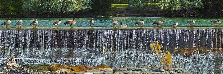 Geese on falls wall Idaho Falls
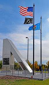 Idaho State Vietnam Veterans Memorial in Freeman Park
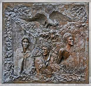 War Memorial close-up
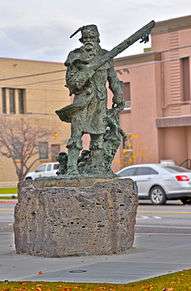 Sculpture of Snake River Fur Trapper by Roy Reynolds on the bank of the Snake River (on the greenbelt) in Idaho Falls
 Idaho Falls Library; sculpture by Marilyn Hoff Hansen dedicated to Wilson Rawls, author of Where the Red Fern Grows
References
- 1 2 "US Gazetteer files 2010". United States Census Bureau. Retrieved 2012-12-18.
- 1 2 "American FactFinder". United States Census Bureau. Retrieved 2012-12-18.
- ↑ "Find a County". National Association of Counties. Retrieved 2011-06-07.
- ↑ Table 4: Annual Estimates of the Population for Incorporated Places in Idaho, Listed Alphabetically: April 1, 2000 to July 1, 2006 (SUB-EST2006-04-16) Accessed 16 July 2007
- ↑ http://quickfacts.census.gov/qfd/states/16/1639700.html
- 1 2 MD Beal, A History of Southeastern Idaho, 1942, p. 218.
- ↑ http://www.idahohistory.net/Reference%20Series/0071.pdf |EAGLE ROCK FERRY
- ↑ Colorado Rail Annual No. 15, 1981, pp 31-39.
- ↑ Deseret News, 1879-07-17 p. article "Utah and Northern" describes the scene at Eagle Rock and describes the new railroad bridge
- ↑ The Snake River Fork County, Louis J. Clements and Harold S. Forbush, 1972 pp 25-27.
- 1 2 Tucker, Todd (2009). Atomic America: How a Deadly Explosion and a Feared Admiral Changed the Course of Nuclear History. New York: Free Press. ISBN 978-1-4165-4433-3. See summary:
- ↑ LA-3611 A Review of Criticality Accidents, William R. Stratton, Los Alamos Scientific Laboratory, 1967
- ↑ LA-13638 A Review of Criticality Accidents (2000 Revision), Thomas P. McLaughlin, et al., Los Alamos National Laboratory, 2000.
- 1 2 Stacy, Susan M. (2000). Proving the Principle - A History of The Idaho National Engineering and Environmental Laboratory, 1949-1999 (PDF). U.S. Department of Energy, Idaho Operations Office. ISBN 0-16-059185-6. Chapter 15.
- ↑ Stacy, Susan M. (2000). Proving the Principle - A History of The Idaho National Engineering and Environmental Laboratory, 1949-1999 (PDF). U.S. Department of Energy, Idaho Operations Office. ISBN 0-16-059185-6. Chapter 16.
- ↑ "The SL-1 Reactor Accident".
- ↑ http://images.businessweek.com/ss/09/11/1117_best_places_to_raise_kids/13.htm
- ↑ http://www.forbes.com/lists/2010/5/business-places-10_Best-Small-Places-For-Business-And-Careers_Rank_3.html
- ↑ http://money.cnn.com/magazines/moneymag/bplive/2010/top100/index4.html
- ↑ Rose, Peter (April 9, 1994). "Melaleuca expands into Canada". The Idaho Business Review. 13 (27): 10.
- 1 2 "10 low-cost locales where jobs are plentiful". Retrieved 2009-05-04.
- ↑ B2X Photo
- ↑ Civic Auditorium
- ↑ Melaleuca Freedom Celebration
- ↑ Museum of Idaho
- ↑ Downtown Development Corporation
- ↑ Adventure Town: Idaho Falls, Idaho
- ↑ http://www.tornadohistoryproject.com/tornado/19780407.16.1
- ↑ "Climatography of the United States NO.81" (PDF). National Oceanic and Atmospheric Administration. Retrieved January 16, 2011.
- ↑ "Monthly Averages for Idaho Falls, ID". The Weather Channel. Retrieved January 16, 2011.
- ↑ "Annual Estimates of the Resident Population for Incorporated Places: April 1, 2010 to July 1, 2015". Retrieved July 2, 2016.
- ↑ "Census of Population and Housing". Census.gov. Retrieved June 4, 2015.
- ↑ "American FactFinder". United States Census Bureau. Retrieved 2008-01-31.
- ↑ Idaho Falls - Idaho Falls - Ancestry & family history - ePodunk
- ↑ "Magnet High School at Clair E. Gale". New Tech Network. Retrieved 2012-04-22.
- ↑ "2008 Great American Rivalry Preview: SKYLINE VS. IDAHO FALLS". iHigh.com. Retrieved 2009-05-23.
- ↑ Idaho Falls Post Register 24 July 2002, pg.C8, "I.F.'s Brush with Fame"
- ↑ The Soap Opera Encyclopedia, Schemering, pg.14, 1985
- ↑ Aprikyan, Tatevik (July 26, 2013). "Japanese students visit Idaho Falls for sister city exchange". Local News 8 of Idaho. Retrieved 17 November 2015.
External links
| Wikivoyage has a travel guide for Idaho Falls. |
| Wikimedia Commons has media related to Idaho Falls, Idaho. |
- City of Idaho Falls
- Idaho Falls Public Library
- Idaho Falls Chamber Of Commerce
- Idaho Falls Convention And Visitors Bureau
-
 "Idaho Falls". Collier's New Encyclopedia. 1921.
Municipalities and communities of Bonneville County, Idaho, United States | ||
|---|---|---|
| Cities | ||
| CDP | ||
| Unincorporated communities | ||
| Footnotes | ‡This populated place also has portions in an adjacent county or counties | |