Blackfoot, Idaho
| Blackfoot, Idaho | |
|---|---|
| City | |
|
Business District of Blackfoot | |
 Location of Blackfoot, Idaho | |
 Blackfoot, Idaho Location in the United States | |
| Coordinates: 43°11′24″N 112°20′46″W / 43.19000°N 112.34611°WCoordinates: 43°11′24″N 112°20′46″W / 43.19000°N 112.34611°W | |
| Country | United States |
| State | Idaho |
| County | Bingham |
| Government | |
| • Mayor | Paul Loomis |
| Area[1] | |
| • Total | 6.07 sq mi (15.72 km2) |
| • Land | 5.83 sq mi (15.10 km2) |
| • Water | 0.24 sq mi (0.62 km2) |
| Elevation | 4,498 ft (1,371 m) |
| Population (2010)[2] | |
| • Total | 11,899 |
| • Estimate (2012[3]) | 11,852 |
| • Density | 2,041.0/sq mi (788.0/km2) |
| Time zone | Mountain (MST) (UTC-7) |
| • Summer (DST) | MDT (UTC-6) |
| ZIP code | 83221 |
| Area code(s) | 208 |
| FIPS code | 16-07840 |
| GNIS feature ID | 0396141 |
| Website | cityofblackfoot.org |

Blackfoot is a city in Bingham County, Idaho, United States. The population was 11,899 at the 2010 census. The city is the county seat of Bingham County.[4] Blackfoot boasts the largest potato industry in any one area, and is known as the "Potato Capital of the World."[5] It is the site of the Idaho Potato Museum (a museum and gift shop that displays and explains the history of Idaho's potato industry), and the home of the world's largest baked potato and potato chip. Blackfoot is also the location of the Eastern Idaho State Fair, which operates between Labor Day weekend and the following weekend.
Blackfoot is the principal city of the Blackfoot, Idaho, Micropolitan Statistical Area, which includes Bingham County.
History
The city of Blackfoot is located near the center of Bingham County, on the south side of the Snake River. It was designated the county seat by the Thirteenth Territorial Legislature on January 13, 1885.[6] Originally, the county seat was to be Eagle Rock (the original name for Idaho Falls). However, supposedly, on the night before the legislation was to be signed, men from Blackfoot bribed a clerk to erase Eagle Rock and write in Blackfoot. The measure went through without opposition and was signed by the governor.[7] The origin of this accusation, written many years after the event, was a Blackfoot newspaper editor named Byrd Trego. The battle for county seat between Eagle Rock and Blackfoot was a political tug-of-war involving sectional and anti-Mormon factions in the Idaho Legislature. The leader of the southeastern Idaho anti-Mormons was a Yale graduate named Fred T. Dubois, who settled in Blackfoot in 1880. The legislative maneuvering to overturn Eagle Rock as the county seat naturally left “disparaging rumors intimating some skullduggery on Blackfoot’s part.”[8]
Frederick S. Stevens and Joe Warren were the first permanent white settlers of record in Bingham County.[9] In 1866 Stevens and Warren filed claims in the Snake River Valley near the present-day location of Blackfoot, where they started farming and ranching.[10] The area was a flat, expansive plain of sagebrush frequented by Indians. To create a place of safety for the scattered settlers when they feared Indian trouble, Mr. Warren outfitted his cabin with holes between the logs where men could stand guard, day or night, until the natives left the neighborhood.[11] When the Utah Northern Railroad signed contracts to expand north into Idaho in the 1870s, some of the settlers laid out a town on the Shilling and Lewis homesteads.[12] The planned town, named Blackfoot, which was what the area had been called by fur traders, was near the Corbett stage station, about a mile from the Snake River, and two miles from the Blackfoot River.[13]
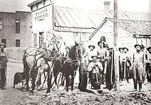
Civil War veteran William Edward Wheeler, from Vermont, was an early settler. On July 1, 1880, Wheeler began publishing a newspaper called the Blackfoot Register.[14] The first issue described the businesses in operation in Blackfoot on the publication date: “four general merchandise stores, one jewelry store, a livery stable, four saloons, a hotel, one meat market, two blacksmith shops, one barber shop and one lumber yard.”[15] Henry W. Curtis opened the first hardware store in 1885.[16]
The first issue of the Blackfoot Register also described “a ditch being dug from the Blackfoot River that would irrigate several thousand acres.”[15] It was their plan to bring the water into town so residents could grow gardens and plant trees.[15] The goal was finally realized in 1886 when Alfred Moyes planted the first shade trees in the Upper Snake River Valley around the Blackfoot Courthouse.[17] Others in town followed suit and within a few years Blackfoot’s tree-lined streets had a reputation that earned the nickname “Grove City.” Sightseeing excursions from the surrounding area were reportedly organized so they could “feast their eyes on this verdure,” which stood in pleasant, stark contrast with the endless acres of dry, gray sagebrush.[17]
Geography
Blackfoot is located at 43°11′24″N 112°20′46″W / 43.19000°N 112.34611°W (43.190068, -112.346037).[18]
According to the United States Census Bureau, the city has a total area of 6.07 square miles (15.72 km2), of which 5.83 square miles (15.10 km2) is land and 0.24 square miles (0.62 km2) is water.[1]
Blackfoot has a semi-arid climate (Köppen BSk) with cold winters and hot, dry summers.
| Climate data for Blackfoot, Idaho | |||||||||||||
|---|---|---|---|---|---|---|---|---|---|---|---|---|---|
| Month | Jan | Feb | Mar | Apr | May | Jun | Jul | Aug | Sep | Oct | Nov | Dec | Year |
| Record high °F (°C) | 60 (16) |
81 (27) |
79 (26) |
88 (31) |
96 (36) |
108 (42) |
103 (39) |
104 (40) |
98 (37) |
88 (31) |
74 (23) |
61 (16) |
108 (42) |
| Average high °F (°C) | 29.5 (−1.4) |
35.9 (2.2) |
48.2 (9) |
57.4 (14.1) |
67.3 (19.6) |
76.2 (24.6) |
85.5 (29.7) |
84.8 (29.3) |
74.2 (23.4) |
60.3 (15.7) |
43.8 (6.6) |
31.1 (−0.5) |
57.9 (14.4) |
| Daily mean °F (°C) | 22.7 (−5.2) |
27.7 (−2.4) |
38.3 (3.5) |
46.1 (7.8) |
55.1 (12.8) |
62.9 (17.2) |
70.5 (21.4) |
69.2 (20.7) |
59.7 (15.4) |
47.4 (8.6) |
34.8 (1.6) |
23.9 (−4.5) |
46.5 (8.1) |
| Average low °F (°C) | 15.9 (−8.9) |
19.6 (−6.9) |
28.5 (−1.9) |
34.9 (1.6) |
42.9 (6.1) |
49.6 (9.8) |
55.5 (13.1) |
53.6 (12) |
45.2 (7.3) |
34.6 (1.4) |
25.7 (−3.5) |
16.7 (−8.5) |
35.2 (1.8) |
| Record low °F (°C) | −40 (−40) |
−39 (−39) |
−19 (−28) |
6 (−14) |
17 (−8) |
24 (−4) |
30 (−1) |
23 (−5) |
12 (−11) |
5 (−15) |
−24 (−31) |
−30 (−34) |
−40 (−40) |
| Average precipitation inches (mm) | 0.72 (18.3) |
0.71 (18) |
1.01 (25.7) |
1.22 (31) |
1.52 (38.6) |
1.23 (31.2) |
0.58 (14.7) |
0.59 (15) |
0.77 (19.6) |
0.93 (23.6) |
0.87 (22.1) |
1.14 (29) |
11.29 (286.8) |
| Source: NOAA (normals — 1981–2010, records — 1895–present) [19] | |||||||||||||
Demographics
| Historical population | |||
|---|---|---|---|
| Census | Pop. | %± | |
| 1880 | 285 | — | |
| 1890 | 538 | 88.8% | |
| 1900 | 1,000 | 85.9% | |
| 1910 | 2,202 | 120.2% | |
| 1920 | 3,937 | 78.8% | |
| 1930 | 3,199 | −18.7% | |
| 1940 | 3,681 | 15.1% | |
| 1950 | 5,780 | 57.0% | |
| 1960 | 7,378 | 27.6% | |
| 1970 | 8,716 | 18.1% | |
| 1980 | 10,065 | 15.5% | |
| 1990 | 9,646 | −4.2% | |
| 2000 | 10,419 | 8.0% | |
| 2010 | 11,899 | 14.2% | |
| Est. 2015 | 11,740 | [20] | −1.3% |
| source:[21] | |||
2010 census
At the 2010 census,[2] there were 11,899 people, 4,229 households and 2,958 families residing in the city. The population density was 2,041.0 inhabitants per square mile (788.0/km2). There were 4,547 housing units at an average density of 779.9 per square mile (301.1/km2). The racial makeup of the city was 83.1% White, 0.3% African American, 3.5% Native American, 1.1% Asian, 0.2% Pacific Islander, 9.1% from other races, and 2.8% from two or more races. Hispanic or Latino of any race were 18.4% of the population.
There were 4,229 households of which 39.3% had children under the age of 18 living with them, 51.4% were married couples living together, 13.0% had a female householder with no husband present, 5.6% had a male householder with no wife present, and 30.1% were non-families. 25.6% of all households were made up of individuals and 11.2% had someone living alone who was 65 years of age or older. The average household size was 2.74 and the average family size was 3.31.
The median age in the city was 30.8 years. 31.3% of residents were under the age of 18; 9.6% were between the ages of 18 and 24; 25.5% were from 25 to 44; 20.8% were from 45 to 64; and 12.8% were 65 years of age or older. The gender makeup of the city was 49.6% male and 50.4% female.
2000 census
At the 2000 census, there were 10,419 people, 3,685 households and 2,682 families residing in the city. The population density was 1,926.4 per square mile (743.6/km²). There were 3,929 housing units at an average density of 726.4 per square mile (280.4/km²). The racial makeup of the city was 86.76% White, 0.21% African American, 2.51% Native American, 1.09% Asian, 0.03% Pacific Islander, 6.33% from other races, and 3.06% from two or more races. Hispanic or Latino of any race were 13.17% of the population.
There were 3,685 households of which 38.8% had children under the age of 18 living with them, 56.9% were married couples living together, 11.8% had a female householder with no husband present, and 27.2% were non-families. 23.7% of all households were made up of individuals and 10.7% had someone living alone who was 65 years of age or older. The average household size was 2.75 and the average family size was 3.27.
31.2% of the population were under the age of 18, 10.9% from 18 to 24, 25.5% from 25 to 44, 18.9% from 45 to 64, and 13.4% who were 65 years of age or older. The median age was 31 years. For every 100 females there were 96.5 males. For every 100 females age 18 and over, there were 91.3 males.
The median household income was $33,004 and the median family income was $36,553. Males had a median income of $31,489 compared with $20,625 for females. The per capita income for the city was $15,529 About 11.5% of families and 14.6% of the population were below the poverty line, including 22.4% of those under age 18 and 5.7% of those age 65 or over.
Education
Blackfoot is served by the Blackfoot School District #55 [22] and the Snake River School District #52.[23]
High schools
- Blackfoot High School[24]
- Independence High School[25]
- Snake River High School[26]
- Bingham Academy
Middle schools
- Mountain View Middle School[28]
- Idaho Science And Technology Charter School
- Snake River Junior High School [29]
- Snake River Middle School [30]
- BCCLC Middle School
Elementary schools
- Blackfoot Sixth Grade School[32]
- Fort Hall Elementary School[33]
- Groveland Elementary School
- Ridgecrest Elementary School
- Donald D. Stalker Elementary School
- I.T. Stoddard Elementary School
- Wapello Elementary School[34]
- Blackfoot Charter Community Learning Center
- Rockford Elementary [35]
- Moreland Elementary [36]
Popular culture references
Blackfoot is mentioned in the song "When Cowboys Didn't Dance" by Lonestar as the destination of a cattle drive.
References
- 1 2 "US Gazetteer files 2010". United States Census Bureau. Archived from the original on 2012-01-24. Retrieved 2012-12-18.
- 1 2 "American FactFinder". United States Census Bureau. Retrieved 2012-12-18.
- ↑ "Population Estimates". United States Census Bureau. Archived from the original on 2013-06-17. Retrieved 2013-06-03.
- ↑ "Find a County". National Association of Counties. Archived from the original on 2011-05-31. Retrieved 2011-06-07.
- ↑ http://www.blackfootidaho.com/local/cityinfo.html
- ↑ Hawley, James H. (1920). History of Idaho the Gem of the Mountains. S.J. Clarke Publishing Company, Chicago. p. 719.
- ↑ "Bingham County History, Written and Compiled by the People of Bingham County". Taylor Publishing Company. 1985. Library of Congress number 85072293
- ↑ Davis Bitton, "The Making of a Community," Idaho Yesterdays, Vol. 19 Issue 1, 1974, 10.
- ↑ Thomas H. Williams, Miracle of the Desert, p.22. Blackfoot, Idaho: published by author, 1957), BYU Harold B. Lee Library, BX 8677.96.255.
- ↑ Works Progress Administration, Federal Writers' Project (1938). Idaho Encyclopedia. Caxton Printers, Ltd. Caldwell, Idaho. p. 227.
- ↑ Hawley, James H. (1920). History of Idaho. Chicago: S.J. Clarke Publishing Company. p. 719.
- ↑ Works Progres Administration, Federal Writers' Project (1938). Idaho Encyclopedia. Caldwell, Idaho: Caxton Printers, Ltd. p. 227.
- ↑ Bitton, Davis (1974). "The Making of a Community". Idaho Yesterdays. BYU Harold B. Lee Library Special Collections. 19 (1): 2, 4.
- ↑ Bitton, Davis (1974). "The Making of a Community". Idaho Yesterdays. BYU Harold B. Lee Library Special Collections. 19 (1): 3.
- 1 2 3 Bitton, Davis (1974). "The Making of a Community". Idaho Yesterdays. BYU Harold B. Lee Library Special Collections. 19 (1): 4.
- ↑ Hawley, James H. (1920). History of Idaho, the Gem of the Mountains. Chicago: S.J. Clarke Publishing Company. p. 614.
- 1 2 James H. Hawley, Editor, History of Idaho, the Gem of the Mountains, (Chicago: S.J. Clarke Publishing Company, 1920), 719.
- ↑ "US Gazetteer files: 2010, 2000, and 1990". United States Census Bureau. 2011-02-12. Retrieved 2011-04-23.
- ↑ "NOWData - NOAA Online Weather Data". National Oceanic and Atmospheric Administration. Retrieved February 9, 2015.
- ↑ "Annual Estimates of the Resident Population for Incorporated Places: April 1, 2010 to July 1, 2015". Retrieved July 2, 2016.
- ↑ Moffatt, Riley. Population History of Western U.S. Cities & Towns, 1850-1990. Lanham: Scarecrow, 1996, 90.
- ↑ http://www.d55.k12.id.us/bfsd_003.htm
- ↑ http://www.snakeriver.org/SR/generalinfo.cfm?ULink=9877348[]
- ↑ http://www.d55.k12.id.us/bhs/bhs.htm
- ↑ http://www.d55.k12.id.us/independence/main.htm
- ↑ "Archived copy". Archived from the original on 2008-05-04. Retrieved 2008-07-29.
- ↑ http://www.bcclc.com/
- ↑ http://www.d55.k12.id.us/mvms/mvms.htm
- ↑ http://srjh.snakeriver.org/
- ↑ http://srms.snakeriver.org/
- ↑ http://bcclc.com/
- ↑ http://www.d55.k12.id.us/bsgs/main.htm
- ↑ http://www.d55.k12.id.us/forthall/main.htm
- ↑ http://www.d55.k12.id.us/wapello/
- ↑ http://rkfd.snakeriver.org/
- ↑ http://mrld.snakeriver.org/
External links
| Wikimedia Commons has media related to Blackfoot, Idaho. |
Municipalities and communities of Bingham County, Idaho, United States | ||
|---|---|---|
| Cities | ||
| CDPs | ||
| Unincorporated communities | ||
| Indian reservation | ||
| Footnotes | ‡This populated place also has portions in an adjacent county or counties | |