Coteau du Missouri
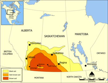
The Coteau du Missouri, or Missouri Plateau, is a large plateau that stretches along the eastern side of the valley of the Missouri River in central North Dakota and north-central South Dakota in the United States.[1][2] In the Canadian provinces of Saskatchewan and Alberta this physiographic region is classified as the uplands Missouri Coteau which is a part of the Great Plains Province or Alberta Plateau Region which extends across the south west corner of the province of Saskatchewan as well as the south east corner of the province of Alberta.[3] Historically, in Canada the area was known as the Palliser's Triangle regarded as an extension of the Great American Desert and unsuitable for agriculture and thus designated by Canadian geographer and explorer John Palliser. The terrain of the Missouri Coteau features low hummocky, undulating, rolling hills, potholes, and grasslands.[4]
.jpg)
Geologically the plateau is part of the extended plateau of the Great Plains in the Dakotas, and is separated from the main plateau to the west by the Missouri River Trench. The plateau is underlain by Pierre shale covered with hardened deposits from repeated glaciations. The plateau also contains deposits of lignite, mirabilite (sodium sulfate), and bentonite. While subjected to continental glaciation, it was north and west of the Driftless Area, an area which escaped glaciation.
The plateau is poorly drained and is interspersed with glacial kettle lakes. It is transversed by several broad sags marking the ancient stream valleys of the eastern continuations of the Grand, Moreau, Cheyenne, Cheyenne River, Bad, and White rivers.
To the east of the plateau, the lowland valley of the James River was formed by the lobe of the most recent ice age, separating the plateau from the Coteau des Prairies to the east.
Agriculturally the plateau is a grain and livestock region.
See also
- Coteau des Prairies
- Geography of Saskatchewan
- Cypress Hills Interprovincial Park
- Cypress Hills (Canada)
- List of highest points of Canadian provinces and territories
References
- ↑ Shjeflo, Jelmer B. "Evapotranspiration and the Water Budget of Prairie Potholes in North Dakota". Retrieved 2012-12-24.
- ↑ John C. Hudson (8 February 2002). Across This Land: A Regional Geography of the United States and Canada. JHU Press. pp. 296–. ISBN 978-0-8018-6567-1.
- ↑ Penner, Lynden, "Missouri Coteau", The Encyclopedia of The Great Plains, retrieved 2007-05-16
- ↑ Richards, J.H.; Fung, K.I. (1969), Atlas of Saskatchewan, University of Saskatchewan: Modern Press
External links
| Physiographic regions |
| ||||||||||
|---|---|---|---|---|---|---|---|---|---|---|---|
| Physical features | |||||||||||
| Parks and protected areas |
| ||||||||||
| Historic regions | |||||||||||
| Aboriginal peoples |
| ||||||||||
| |||||||||||
| Lists |  | |
|---|---|---|
| Geography | ||
| Native American tribes | ||
| History | ||
| Engineering | ||
| Parks and preserves | ||
Coordinates: 50°48′N 109°12′W / 50.8°N 109.2°W