Valley City, North Dakota
| City of Valley City | |
|---|---|
| City | |
|
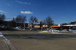
Central Ave and Main Street in Valley City | |
| Motto: "City of Bridges" | |
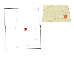 Location of Valley City, North Dakota | |
 City of Valley City Location of Valley City, North Dakota | |
| Coordinates: 46°55′29″N 98°0′20″W / 46.92472°N 98.00556°WCoordinates: 46°55′29″N 98°0′20″W / 46.92472°N 98.00556°W | |
| Country | United States |
| State | North Dakota |
| County | Barnes |
| Government | |
| • Mayor | Robert Werkhoven |
| Area[1] | |
| • Total | 3.46 sq mi (8.96 km2) |
| • Land | 3.46 sq mi (8.96 km2) |
| • Water | 0 sq mi (0 km2) |
| Elevation | 1,217 ft (371 m) |
| Population (2010)[2] | |
| • Total | 6,585 |
| • Estimate (2015)[3] | 6,669 |
| • Density | 1,903.2/sq mi (734.8/km2) |
| Time zone | Central (CST) (UTC-6) |
| • Summer (DST) | CDT (UTC-5) |
| ZIP code | 58072 |
| Area code(s) | 701 |
| FIPS code | 38-81180 |
| GNIS feature ID | 1032618[4] |
| Highways | I-94, I-94 Bus. |
| Website | http://www.valleycity.us |
Valley City is a city in Barnes County, North Dakota, United States. It is the county seat of Barnes County.[5] The population was 6,585 during the 2010 census,[6] making it the thirteenth largest city in North Dakota. Valley City was founded in 1874.
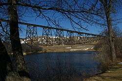
The city is known for its many bridges over the Sheyenne River including the Hi-Line Railroad Bridge. These bridges have earned it the distinction of being called the "City of Bridges". The city is also the home of Valley City State University and the home for the North Dakota High School Activities Association (NDHSAA).
History
Valley City was originally called Worthington, and under the latter name was laid out in 1874 when the railroad was extended to that point.[7] The present name is for the city's location in the valley of the Sheyenne River.[8] A post office was established under the name Worthington in 1874, and has continued to operate under the name Valley City since 1878.[9]
Geography
Valley City is located at 46°55′29″N 98°0′20″W / 46.92472°N 98.00556°W (46.924632, -98.005438).[10]
According to the United States Census Bureau, the city has a total area of 3.46 square miles (8.96 km2), all of it land.[1]
Demographics
| Historical population | |||
|---|---|---|---|
| Census | Pop. | %± | |
| 1880 | 302 | — | |
| 1890 | 1,089 | 260.6% | |
| 1900 | 2,446 | 124.6% | |
| 1910 | 4,606 | 88.3% | |
| 1920 | 4,686 | 1.7% | |
| 1930 | 5,268 | 12.4% | |
| 1940 | 5,917 | 12.3% | |
| 1950 | 6,851 | 15.8% | |
| 1960 | 7,809 | 14.0% | |
| 1970 | 7,843 | 0.4% | |
| 1980 | 7,774 | −0.9% | |
| 1990 | 7,163 | −7.9% | |
| 2000 | 6,826 | −4.7% | |
| 2010 | 6,585 | −3.5% | |
| Est. 2015 | 6,669 | [11] | 1.3% |
| U.S. Decennial Census[12] 2015 Estimate[3] | |||
2010 census
As of the census[2] of 2010, there were 6,585 people, 2,986 households, and 1,563 families residing in the city. The population density was 1,903.2 inhabitants per square mile (734.8/km2). There were 3,307 housing units at an average density of 955.8 per square mile (369.0/km2). The racial makeup of the city was 95.2% White, 1.2% African American, 0.7% Native American, 0.8% Asian, 0.2% from other races, and 1.7% from two or more races. Hispanic or Latino of any race were 1.5% of the population
There were 2,986 households of which 22.6% had children under the age of 18 living with them, 41.1% were married couples living together, 7.9% had a female householder with no husband present, 3.3% had a male householder with no wife present, and 47.7% were non-families. 39.4% of all households were made up of individuals and 17.9% had someone living alone who was 65 years of age or older. The average household size was 2.04 and the average family size was 2.74.
The median age in the city was 42.1 years. 18.7% of residents were under the age of 18; 13.2% were between the ages of 18 and 24; 21.1% were from 25 to 44; 24.9% were from 45 to 64; and 22% were 65 years of age or older. The gender makeup of the city was 48.1% male and 51.9% female.
2000 census
As of the census of 2000, there were 6,826 people, 2,996 households, and 1,668 families residing in the city. The population density was 2,062.5 per square mile (796.2/km²). There were 3,250 housing units at an average density of 982.0 per square mile (379.1/km²). The racial makeup of the city was 97.39% White, 0.73% African American, 0.75% Native American, 0.28% Asian, 0.19% from other races, and 0.66% from two or more races. Hispanic or Latino of any race were 0.82% of the population.
The top 6 ancestry groups in the city are German (45.5%), Norwegian (38.8%), Irish (9.1%), Swedish (5.2%), French (4.8%), English (3.8%).
There were 2,996 households out of which 23.3% had children under the age of 18 living with them, 44.6% were married couples living together, 8.1% had a female householder with no husband present, and 44.3% were non-families. 38.3% of all households were made up of individuals and 19.6% had someone living alone who was 65 years of age or older. The average household size was 2.09 and the average family size was 2.77.
In the city the population was spread out with 18.8% under the age of 18, 15.3% from 18 to 24, 21.4% from 25 to 44, 21.4% from 45 to 64, and 23.1% who were 65 years of age or older. The median age was 41 years. For every 100 females there were 89.4 males. For every 100 females age 18 and over, there were 87.5 males.
The median income for a household in the city was $28,050, and the median income for a family was $41,604. Males had a median income of $30,035 versus $17,667 for females. The per capita income for the city was $16,257. About 5.5% of families and 12.4% of the population were below the poverty line, including 11.9% of those under age 18 and 12.8% of those age 65 or over.
Local media
AM Radio
| AM Radio stations | |||||
|---|---|---|---|---|---|
| Frequency | Call sign | Name | Format | Owner | City |
| 1490 AM | KOVC | Dakota Country Radio | Full Service (radio format)/Country | Ingstad Family Media | Valley City |
FM Radio
| FM radio stations | ||||||
|---|---|---|---|---|---|---|
| Frequency | Call sign | Name | Format | Owner | Target city/market | City of license |
| 102.7 FM | K274BH | Sunny 98.3 | Adult Contemporary KXGT-FM translator | Ingstad Family Media | Valley City | Valley City |
- CSiCable
The local newspaper is the Valley City Times-Record.
Education
K-12
Valley City is served by the Valley City Public School District which consists of Jefferson Elementary School, Washington Elementary School, and Valley City Junior/Senior High School and St. Catherines Catholic School for grade K - 6
Higher education
Sites of interest
.jpg)
Notable people
- Jeff Boschee, professional basketball player
- Paul Fjelde, sculptor; professor at Pratt Institute
- John E. Grotberg, US congressman
- Peggy Lee, jazz and popular music singer, songwriter, composer, and actress
- George W. Mason, chairman and CEO of Kelvinator and American Motors Company
- James M. McPherson, Civil War historian; Pulitzer Prize winner
- Gerhard Brandt Naeseth, genealogist; founder of the Norwegian-American Genealogical Center & Naeseth Library
- Earl Pomeroy, US congressman
- Ann Sothern, film and TV actress with two stars on the Hollywood Walk of Fame
- Carol Thurston, actress
- Frank White, eighth governor of North Dakota and Treasurer of the United States (1921-1928)
- George M. Young, US Congressman, judge
Climate
This climatic region is typified by large seasonal temperature differences, with warm to hot (and often humid) summers and cold (sometimes severely cold) winters. According to the Köppen Climate Classification system, Valley City has a humid continental climate, abbreviated "Dfb" on climate maps.[13]
References
- 1 2 "US Gazetteer files 2010". United States Census Bureau. Retrieved 2012-06-14.
- 1 2 "American FactFinder". United States Census Bureau. Retrieved 2012-06-14.
- 1 2 "Population Estimates". United States Census Bureau. Retrieved June 1, 2016.
- ↑ "US Board on Geographic Names". United States Geological Survey. 2007-10-25. Retrieved 2008-01-31.
- ↑ "Find a County". National Association of Counties. Retrieved 2011-06-07.
- ↑ "2010 Census Redistricting Data (Public Law 94-171) Summary File". American FactFinder. United States Census Bureau. Retrieved 2 May 2011.
- ↑ North Dakota: Counties, Towns and People. Watchmaker Publishing, Ltd. 2008. p. 14. ISBN 978-1-60386-115-1.
- ↑ Federal Writers' Project (1938). North Dakota, a Guide to the Northern Prairie State,. WPA. p. 280. ISBN 978-1-62376-033-5.
- ↑ "Barnes County". Jim Forte Postal History. Retrieved 22 October 2015.
- ↑ "US Gazetteer files: 2010, 2000, and 1990". United States Census Bureau. 2011-02-12. Retrieved 2011-04-23.
- ↑ "Annual Estimates of the Resident Population for Incorporated Places: April 1, 2010 to July 1, 2015". Retrieved July 2, 2016.
- ↑ United States Census Bureau. "Census of Population and Housing". Retrieved July 22, 2013.
- ↑ Climate Summary for Valley City, North Dakota
External links
| Wikivoyage has a travel guide for Valley City (North Dakota). |
- Valley City, North Dakota official tourism website
- Valley City, North Dakota official city government website
- Community data for industry : Valley City, North Dakota (1980) from the Digital Horizons website
 |
Cooperstown | | ||
| Jamestown | |
Casselton | ||
| ||||
| | ||||
| LaMoure |
Municipalities and communities of Barnes County, North Dakota, United States | ||
|---|---|---|
| Cities | 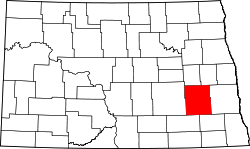 | |
| Townships |
| |
| Unincorporated communities | ||
| Footnotes | ‡This populated place also has portions in an adjacent county or counties | |