Kokernag
| Kokernag Brang kokernag کۄکَرناگ कोकरनाग | |
|---|---|
| Sub-District | |
| Nickname(s): Brang kokernag | |
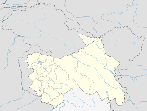
 Kokernag  Kokernag Location in Jammu and Kashmir, India | |
| Coordinates: 33°35′05″N 75°18′31″E / 33.584721°N 75.308601°ECoordinates: 33°35′05″N 75°18′31″E / 33.584721°N 75.308601°E | |
| Country |
|
| State | Jammu and Kashmir |
| District | Anantnag |
| Government | |
| • Type | Parliamentary |
| • Body | Municipal |
| Elevation | 2,000 m (7,000 ft) |
| Population (2011) | |
| • Total | 173,712 |
| Languages | |
| • Official | Urdu, Kashmiri, Gogeri |
| Time zone | IST (UTC+5:30) |
| PIN | 192202 |
| Vehicle registration | JK03 |
| Website | Anantnag District |
Kokernag is a sub-district town and a notified area committee in Breng Valley (The Golden Crown of Kashmir), Anantnag district in the Indian administered state of Jammu & Kashmir. The etymology of the word 'Kokernag' is controversial and there are various theories and none has any conclusive historical proof. As per one such theory Koker means 'fowl' and nag means 'serpent'. The spring gushes out of the base of a thickly wooded hill from where it divides into channels, which resembles to the claw-foot of a hen, hence its name. The other theory is that the word Kokernag originates from Koh (Mountain) kan (from or under) nag (spring). Kokernag is at the height of approx. 2,000 m above sea level. Place is known for gardens, largest fresh water springs in Kashmir and for its largest rainbow trout hatchery in north India. Towns and village situated around Kokernag are Bindoo, Zalangam, Bidder, Wangam, Hangalgund,Nagam, Mukhdampora Sagam,Duksum, Soaf Shali etc. Kokernag has been mentioned in Ain Akbari, where in it has been mentioned that the water of Kokernag satisfies both hunger and thirst and it is also a remedy for indigestion.[1]
Etymology
The name Kokernag has been derived from the two words namely, koker and nag. Koker has been taken from a Kashmiri word for chicken, while nag has been taken from Sanskrit word for springs. Kokernag is situated in the Anantnag District, whose name means abundant springs.
Demographics
According to the 2001 India census,[2] Kokernag had a population of 4,548. Males constitute 68% of the population and females 32%. Kokernag has an average literacy rate of 63%, higher than the national average of 59.5%: male literacy is 77%, and female literacy is 33%. In Kokernag, 9% of the population is aged under 6 years.
Background
Basically, the nickname or second name of Kokernag is Breng Kokernag, the name given by Shiekh ul Alam, poet and scholar. He said "" kokernag breng chu sunsund preng"" which means that ""kekernag is Golden crown of kashmir"" means a precious thing. Kokernag is a collection of many small springs and their collective appearance resembles to the claws of a koker (cock). Kokernag is the largest fresh water spring in Kashmir.
Koker means 'fowl' and nag means 'Springs'. The spring gushes out of the base of a thickly wooded hill from where it divides into channels, which resembles to the claw-foot of a hen, hence its name. Kokernag is at the height of approximately 2,000 m above sea level. Place is known for gardens, largest fresh water springs in Kashmir and for its trout streams. Towns and village situated around Kokernag are Wangam, Hangalgund, Nagam, Sagam, Zalergam, Dacksum, Elakti, Soaf Shali .
It is known for its trout streams and the largest fresh water spring in Kashmir, Trout hatchery department which has constructed pools in series where in trout is reared. The total area of Kokernag is 300 Kanals of which 129 kanals is for the purpose of gardens and the rest is forest area.
Notable persons
- Rahim Rather Nagam, politician.
- Mushtaq Ahmad Wani Soaf Shali, Islamic preacher.
National Connectivity
- National Highway 1B (Anantnag, 25 km; Kokernag, 45 km; Synthan top, 74 km, Kishtwar, 152 km.
Airport
Kokernag does not have an airport. The nearest airport is Srinagar International Airport 88 km away, with scheduled flights from Delhi, Mumbai, Kolkata, Chennai, Chandegarh and Jammu.
Railway
Nearest railway station is Anantnag railway station on the 119 km long Kashmir Railway that runs from Baramulla to Banihal. It lies at a distance of 30 km from kokernag.
Religion
- Muslim=99%
- other=1%
References
- ↑ Tourism, Janmu and Kashmir. "Kokernag". J & K Tourism. Retrieved 5 February 2014.
- ↑ "Census of India 2001: Data from the 2001 Census, including cities, villages and towns (Provisional)". Census Commission of India. Archived from the original on 2004-06-16. Retrieved 2008-11-01.