L'Aiguillon
| L'Aiguillon | |
|---|---|
|
War memorial | |
 L'Aiguillon | |
|
Location within Occitanie region  L'Aiguillon | |
| Coordinates: 42°55′N 1°54′E / 42.92°N 1.90°ECoordinates: 42°55′N 1°54′E / 42.92°N 1.90°E | |
| Country | France |
| Region | Occitanie |
| Department | Ariège |
| Arrondissement | Foix |
| Canton | Lavelanet |
| Intercommunality | Pays d'Olmes |
| Government | |
| • Mayor (2008–2020) | Claude Camanes |
| Area1 | 6.37 km2 (2.46 sq mi) |
| Population (2009)2 | 392 |
| • Density | 62/km2 (160/sq mi) |
| Time zone | CET (UTC+1) |
| • Summer (DST) | CEST (UTC+2) |
| INSEE/Postal code | 09003 / 09300 |
| Elevation |
457–920 m (1,499–3,018 ft) (avg. 463 m or 1,519 ft) |
|
1 French Land Register data, which excludes lakes, ponds, glaciers > 1 km² (0.386 sq mi or 247 acres) and river estuaries. 2 Population without double counting: residents of multiple communes (e.g., students and military personnel) only counted once. | |

L'Aiguillon is a French commune in the Ariège department in the Occitanie region of southwestern France.
The inhabitants of the commune are known as Aiguillonnois or Aiguillonnoises[1]
Geography
Location
L'Aiguillon is part of the natural region of Olmes Country and lies halfway between Lavelanet, the capital of the canton and Bélesta. It has a number of hamlets and localities including Terris, Durenat, Couchou, Pagès, Jordy, Ramoundino, Les Peyriquets, Saint Charles, and Roudière.[2]
The D117 road (the former National Route N117) passes through the commune and is joined in the centre of the village by the D16 road.[2]
Neighbouring communes and villages[3]
 |
Dreuilhe | Lesparrou | | |
| Saint-Jean-d'Aigues-Vives | |
|||
| ||||
| | ||||
| Montsegur | Fougax-et-Barrineuf | Bélesta |
Hydrology
The Hers traverses the commune in the north at the foot of the Crète de l’Arse. Several tributaries join it within the commune: streams of Benaix, Mede, and Bacref.[2]
Geology and relief
The commune lies at the bottom of a gorge carved by the Hers in the Massif de Plantaurel of the Pyrenees Mountains.[4] The village is sandwiched between the peak of Mede to the south which rises to 912 metres (2,992 feet) above sea level and the peak of the Arse to the north whose highest point is 718 metres (2,356 feet). The latter is cut off from the Bouchard peak by the Balussous Pass where the Hers turns north (see map).[5]
Toponymy
L'Aiguillon was formerly spelled L’Éguillon.[6]
In Occitan L'Aiguillon is called agulhon which means "a sharp height".[7]
History
The Lordship of L'Aiguillon came under Mirepoix until the sharing of the fief in 1329 when it passed to the authority of Léran. From the 16th century L'Aiguillon was part of the barony of Bélesta with the lordships of Bélesta and Fougax. The village was part of the commune of Bélesta until its separation in 1926.[8]
The main industries in the 19th and 20th centuries were, as is the case in all of Olmes Country, were those of horn comb manufacturing (formerly made of boxwood) and spinning.[8]
Administration
List of mayors[9]
| From | To | Name | Party | Position |
|---|---|---|---|---|
| 2001 | 2008 | Christian Vanhooydonck | ||
| 2008 | 2020 | Claude Camanes |
(Not all data is known)
Demography
In 2009 L'Aiguillon had 392 inhabitants (a decrease of 8% compared to 1999). The commune held the 19,153rd place at the national level, while it was at 17,083rd in 1999 and 77th at the departmental level out of 332 communes.
The commune was created out of Bélesta in 1926.
The evolution of the number of inhabitants is known through the population censuses conducted in the commune since 1926. From the 21st century, a census of communes with fewer than 10,000 inhabitants is held every five years, unlike larger towns that have a sample survey every year.[Note 1]
The maximum population was reached in 1990 with 480 residents.
| 1901 | 1906 | 1911 | 1921 | 1926 | 1931 | 1936 | 1946 | 1954 |
|---|---|---|---|---|---|---|---|---|
| 420 | 423 | 408 | 414 |
| 1962 | 1968 | 1975 | 1982 | 1990 | 1999 | 2006 | 2010 | - |
|---|---|---|---|---|---|---|---|---|
| 403 | 372 | 391 | 437 | 480 | 424 | 403 | 392 | - |
Sources : Ldh/EHESS/Cassini until 1962, INSEE database from 1968 (population without double counting and municipal population from 2006)

Sites and monuments

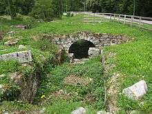
- A Sawmill in marble from the 19th century (built under an authorisation of Charles X on 21 February 1827) was updated in 2005. *A building which was a Flour mill prior to 1747, was transformed into a factory making horn combs but is now in ruins.[10]
- The Church combines both classical and modern architectural features (especially the entrance). Formerly consecrated to the Virgin Mary, it is now dedicated to Saint Sernin. There was also a chapel dedicated to Saint Michael near the present church (late 15th century).[8]
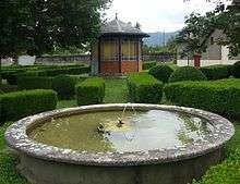
- A French formal garden next to the cemetery with a gazebo at its centre.[8]
- There are also several Monumental Crosses.
Notable people linked to the commune
- Father Edouard Lafuste (died 17 November 1935 in L'Aiguillon), the village priest, was the author of numerous historical studies.[8]
See also
- Communes of the Ariège department
- Cantons of the Ariège department
- Arrondissements of the Ariège department
External links
- L’Aiguillon on the old National Geographic Instituite website (French)
- L'Aiguillon on Lion1906
- L'Aiguillon on Google Maps
- L'Aiguillon on Géoportail, National Geographic Institute (IGN) website (French)
- 'l'Eguillon on the 1750 Cassini Map
- L'Aiguillon on the INSEE website (French)
- INSEE (French)
Notes and references
Notes
- ↑ At the beginning of the 21st century, the methods of identification have been modified by law No. 2002-276 of 27 February 2002 , the so-called "law of local democracy" and in particular Title V "census operations" which allow, after a transitional period running from 2004 to 2008, the annual publication of the legal population of the different French administrative districts. For municipalities with a population greater than 10,000 inhabitants, a sample survey is conducted annually, the entire territory of these municipalities is taken into account at the end of the period of five years. The first "legal population" after 1999 under this new law came into force on 1 January 2009 and was based on the census of 2006.
References
- ↑ Inhabitants of Ariège (French)
- 1 2 3 IGN Map of L’Aiguillon, Géoportail, consulted on 13 June 2011 (French).
- ↑ Google Maps
- ↑ Louis Claeys, André Lagarde, Claudine Pailhès, Daniel Pédoussat, Michel Sébastien, and Robert Simonnet, Encyclopedia Bonneton of Ariège, Éditions Bonneton, Paris, 2001, 319 pages, p. 194, ISBN 2-86253-200-2, consulted on 13 June 2011 (French).
- ↑ L’Aiguillon, Association of councils and councillors of Ariège, consulted on 13 June 2011 (French).
- ↑ Briand de Verzé, Geographic Dictionary of France, Éditions Belin, 1839, 660 pages, p. 500, Read online, consulted on 11 June 2011 (French).
- ↑ Ernest Nègre, General Toponymy of France (Non-Romanesque forms; forms of dialectal), Librairie Droz, Genève, 1996, vol. 2, 1381 pages, p. 1187, ISBN 978-2-600-00133-5, Read online, consulted on 13 June 2011 (French).
- 1 2 3 4 5 L’Aiguillon, Jean-Jacques Pétris, histariege.com, consulted on 13 June 2011 (French).
- ↑ List of Mayors of France (French)
- ↑ A mill can conceal another, Laurence Cabrol, 28 October 2005, Ariège News, consulted on 13 June 2011 (French)
| Wikimedia Commons has media related to L'Aiguillon. |