Lamitan
| Lamitan | ||
|---|---|---|
| Component City | ||
|
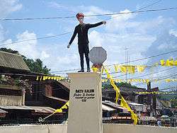
Datu Kalun Shrine in Lamitan City | ||
| ||
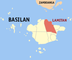 Map of Basilan with Lamitan highlighted | ||
.svg.png) Lamitan Location within the Philippines | ||
| Coordinates: 06°39′N 122°08′E / 6.650°N 122.133°ECoordinates: 06°39′N 122°08′E / 6.650°N 122.133°E | ||
| Country | Philippines | |
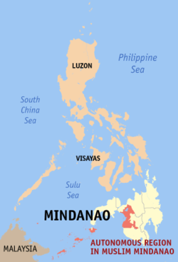
| Region | Autonomous Region in Muslim Mindanao (ARMM) | |
| Province | Basilan | |
| District | Lone district of Basilan | |
| Founded | 1886 | |
| Cityhood | June 8, 2007 | |
| Barangays | 45 | |
| Government[1] | ||
| • Mayor | Rosita U. Furigay | |
| Area[2] | ||
| • Total | 264.45 km2 (102.10 sq mi) | |
| Population (2015)[3] | ||
| • Total | 74,782 | |
| • Density | 280/km2 (730/sq mi) | |
| Time zone | PHT (UTC+8) | |
| ZIP code | 7302 | |
| Dialing code | 62 | |
| Income class | 6th class | |
| Website |
lamitancity | |

Lamitan, officially City of Lamitan (Chavacano: Ciudad de Lamitan), is a sixth class city in the province of Basilan, Mindanao, Philippines. According to the 2015 census, it has a population of 74,782 people.[3]
The city is bounded on the east by the municipality of Tuburan, on the south by Tipo-Tipo, on the west by Isabela City and on the north by Basilan Strait.
Geography
The terrain is relatively plain along the coastal areas and hilly in some areas. The urban area is 2.5 meters above sea level and gently sloping to 300 meters toward the hinterlands.
Climate
The climatic condition is the same with other areas in the entire Basilan Island. It has a "D" type of climate and rainfall is evenly distributed throughout the year.
History
-
During the 11th Congress (1998–2001), Congress enacted into law 33 bills converting 33 municipalities into cities. However, Congress did not act on a further 24 bills converting 24 other municipalities into cities.
During the 12th Congress (2001–2004), Congress enacted into law Republic Act No. 9009 (RA 9009), which took effect on 30 June 2001. RA 9009 amended Section 450 of the Local Government Code by increasing the annual income requirement for conversion of a municipality into a city from ₱20 million to ₱100 million. The rationale for the amendment was to restrain, in the words of Senator Aquilino Pimentel, "the mad rush" of municipalities to convert into cities solely to secure a larger share in the Internal Revenue Allotment despite the fact that they are incapable of fiscal independence.
After RA 9009 went into effect, the House of Representatives of the 12th Congress adopted Joint Resolution No. 29, which sought to exempt from the ₱100 million income requirement in RA 9009 the 24 municipalities whose cityhood bills were not approved in the 11th Congress. However, the 12th Congress ended without the Senate having approved Joint Resolution No. 29.
During the 13th Congress (2004–2007), the House of Representatives re-adopted former Joint Resolution No. 29 as Joint Resolution No. 1 and forwarded it to the Senate for approval. However, the Senate again failed to approve the Joint Resolution. Following the suggestion of Senator Aquilino Pimentel (Senate President), 16 municipalities filed, through their respective sponsors, individual cityhood bills. The 16 cityhood bills each contained a common provision exempting it from the ₱100 million income requirement of RA 9009 –
"Exemption from Republic Act No. 9009. — The City of x x x shall be exempted from the income requirement prescribed under Republic Act No. 9009."
On 22 December 2006, the House of Representatives approved the cityhood bills. The Senate also approved the cityhood bills in February 2007, except that of Naga, Cebu which was passed on 7 June 2007. These cityhood bills lapsed into law on various dates from March to July 2007 after President Gloria Macapagal-Arroyo failed to sign them.
On June 18, 2007 voters in Lamitan ratified Republic Act 9393. 26,636 voted "yes" while only 177 voted against.The point of law at issue in 2007 was whether there had been a breach of Section 10, Article X of the 1987 Constitution, which provides –
No province, city, municipality, or barangay shall be created, divided, merged, abolished or its boundary substantially altered, except in accordance with the criteria established in the local government code and subject to approval by a majority of the votes cast in a plebiscite in the political units directly affected.
– and in each case the established criteria were far from met.
In November 2008, Lamitan and 15 other cities lost their cityhood after the Supreme Court of the Philippines granted a petition filed by the League of Cities of the Philippines, and declared unconstitutional the cityhood law (RA 9393) which had allowed the town to acquire its city status.[4] The Supreme Court ruled that they did not pass the requirements for cityhood.[5][6]
On 10 December 2008, the 16 cities affected acting together filed a motion for reconsideration with the Supreme Court. More than a year later, on 22 December 2009, acting on said appeal, the Court reversed its earlier ruling as it ruled that "at the end of the day, the passage of the amendatory law" (regarding the criteria for cityhood as set by Congress) "is no different from the enactment of a law, i.e., the cityhood laws specifically exempting a particular political subdivision from the criteria earlier mentioned. Congress, in enacting the exempting law/s, effectively decreased the already codified indicators."[7] Accordingly cityhood status was restored.
But on 27 August 2010, the 16 cities lost their city status again, after the Supreme Court voted 7-6, with two justices not taking part, to reinstate the 2008 decision declaring as "unconstitutional" the Republic Acts that converted the 16 municipalities into cities. A previous law required towns aspiring to become cities to earn at least ₱100 million annually, which none of the 16 did.[8]
On 15 February 2011, the Supreme Court made another volte-face and upheld for the third time the cityhood of 16 towns in the Philippines.[9]
Finally, on 12 April 2011, the Supreme Court, in an en banc ruling delivered in Baguio City, affirmed the finality of the constitutionality of the 16 cityhood laws by resolving that:
We should not ever lose sight of the fact that the 16 cities covered by the Cityhood Laws not only had conversion bills pending during the 11th Congress, but have also complied with the requirements of the LGC prescribed prior to its amendment by R.A. No. 9009.[8] Congress undeniably gave these cities all the considerations that justice and fair play demanded. Hence, this Court should do no less by stamping its imprimatur to the clear and unmistakable legislative intent and by duly recognizing the certain collective wisdom of Congress. WHEREFORE, the Ad Cautelam Motion for Reconsideration (of the Decision dated 15 February 2011) is denied with finality.[9]
On 28 June 2011 the Supreme Court directed the Clerk of Court to issue the entry of judgment on the cityhood case of 16 municipalities.[10] This entry of judgment ended the cityhood battle of the 16 cities.
Barangays
Lamitan is politically subdivided into 45 barangays.
- Arco
- Ba-as
- Baimbing
- Balagtasan
- Balas
- Balobo
- Bato
- Boheyakan
- Buahan
- Boheibu
- Bohesapa
- Bulingan
- Cabobo
- Campo Uno
- Colonia
- Calugusan
- Kulay Bato
- Limo-ok
- Lo-ok
- Lumuton
- Luksumbang
- Malo-ong Canal
- Malo-ong San Jose
- Parangbasak
- Santa Clara
- Tandong Ahas
- Tumakid
- Ubit
- Bohebessey
- Baungos
- Danit-Puntocan
- Sabong
- Sengal
- Ulame
- Bohenange
- Boheyawas
- Bulanting
- Lebbuh
- Maganda (Pob.)
- Malakas (Pob.)
- Maligaya (Pob.)
- Malinis (Pob.)
- Matatag (Pob.)
- Matibay (Pob.)
- Simbangon
Demographics
| Population Census of Lamitan | ||
|---|---|---|
| Year | Pop. | ±% p.a. |
| 1990 | 47,859 | — |
| 1995 | 54,433 | +2.44% |
| 2000 | 58,709 | +1.63% |
| 2007 | 82,074 | +4.73% |
| 2010 | 68,996 | −6.12% |
Historical sites
Datu Kalun Shrine – Built as a tribute to a famous Yakan leader and founder of Lamitan. His descendants are the Antonio-Cuevas-Pamaran clan.
Museum of Lamitan – Showcases the color and highlights of the Lami-lamihan festival. It also serves as the information center for the development of this town.
Education
Tertiary
Lamitan is home to one (1) state college and three (3) private colleges. The Basilan State College is an extension college of the main SUC in Isabela City. The three HEIs are the Mindanao Autonomous College, the Mariam School of Nursing and Furigay Colleges, Inc. (FCI).
The Mariam School of Nursing was established in 2004 as part of its Chairwoman's educational outreach program and was named Mariam or Mother Mary - a unifying and guiding figure among the Christians and Muslims. Also offers 11 Tesda Qualifications for National Certificates.
Secondary
Lamitan City has Seven Secondary Schools: one Private Secondary School; the Claret School of Lamitan,one Laboratory School of Basilan State College and five National High Schools i.e. Lamitan National High School, Look National High School,Colony National High School,Ubit National High School and Parangbasak National High School.
Elementary
There are five districts that composed of thirty nine elementary schools namely; Lamitan East District, South District,Central District, West I District and West II District. There are four private elementary schools.
References
- ↑ "Official City/Municipal 2013 Election Results". Intramuros, Manila, Philippines: Commission on Elections (COMELEC). 12 May 2014. Retrieved 20 August 2014.
- ↑ "Land Area". www.basilan.gov.ph. Province of Basilan. Retrieved 20 August 2014.
- 1 2 "Total Population by Province, City, Municipality and Barangay: as of May 1, 2010" (PDF). 2010 Census of Population and Housing. National Statistics Office. Retrieved 20 August 2014.
- ↑ Republic Act No. 9393 of 15 March 2007 Charter of the City of Lamitan
- ↑ G.R. No. 176951 et al. (First appeal) of 18 November 2008 Consolidated petitions for prohibition assailing the constitutionality of the subject Cityhood Laws and enjoining the Commission on Elections (COMELEC) and respondent municipalities from conducting plebiscites pursuant to the Cityhood Laws.
- ↑ Napallacan, Jhunex (2008-11-21). "Cities' demotion worries DepEd execs". Cebu Daily News. Inquirer.net. Retrieved 15 February 2015.
- ↑ G.R. No. 176951 et al. (First reversal) of 21 December 2009
- 1 2 Republic Act No. 9009 of 24 February 2001 An Act amending section 450 of Republic Act no. 7160, otherwise known as the Local Government Code of 1991, by increasing the average annual income requirement for a municipality or cluster of barangays to be converted into a component city.
- 1 2 G.R. No. 176951 et al. (Second appeal) of 15 February 2011 League of Cities of the Philippines v. COMELEC
- ↑ G.R. No. 176951 et al. (Final Resolution) of 28 June 2011 Supreme Court has directed the Clerk of Court to forthwith issue the Entry of Judgment
External links
| Wikimedia Commons has media related to Lamitan. |
- Sun Star Zamboanga : Basilan province has two cities now
- Philippine Standard Geographic Code
- Philippine Census Information
- www.abs-cbnnews.com, Fire guts Lamitan City hall in Basilan
 |
Zamboanga City Basilan Strait |
| ||
| Isabela | |
Akbar Tuburan | ||
| ||||
| | ||||
| Sumisip | Ungkaya Pukan / Tipo-Tipo |