Tandag
| Tandag | |||
|---|---|---|---|
| Component City | |||
| City of Tandag | |||
| |||
 Map of Surigao del Sur with Tandag City highlighted | |||
.svg.png) Tandag Location within the Philippines | |||
| Coordinates: 09°04′N 126°11′E / 9.067°N 126.183°ECoordinates: 09°04′N 126°11′E / 9.067°N 126.183°E | |||
| Country | Philippines | ||
| Region | Caraga (Region XIII) | ||
| Province | Surigao del Sur | ||
| Congr. districts | 1st district of Surigao del Sur | ||
| Cityhood | 23 June 2007 | ||
| Barangays | 21 | ||
| Government[1] | |||
| • Mayor | Alexander T. Pimentel | ||
| • Vice Mayor | Ruel D. Momo | ||
| Area[2] | |||
| • Total | 291.73 km2 (112.64 sq mi) | ||
| Elevation | 4 m (13 ft) | ||
| Population (2010)[3] | |||
| • Total | 56,364 | ||
| • Density | 190/km2 (500/sq mi) | ||
| Time zone | PST (UTC+8) | ||
| ZIP code | 8300 | ||
| Dialing code | 86 | ||
| Income class | 5th class | ||
| Website |
www | ||

Tandag, officially the City of Tandag and often referred to as Tandag City, is a fifth income class city and the provincial capital of the province of Surigao del Sur, Philippines, on the island of Mindanao. According to the 2015 census, it has a population of 56,364 people.[4]
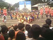
The city celebrates the "Diwatahan Festival" on the third week of January in honor of Señor Sto. Niño. It also celebrates "Araw ng Tandag" every September 10 showcasing the city's blissful achievements through the years.
Farming and fishing are the main economic activity for most of the people in Tandag. Chief farm products are rice, corn, and coconut. Livestock and poultry raising are also important sources of income. Tandag has a national secondary airport and a seaport.
Geography
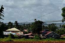
Tandag City is located along the northeastern coast of Mindanao Island facing the Philippine Sea. It is bounded on the north by the municipalities of Cortes and Lanuza, on the east by the Philippine Sea, on the south by the towns of Tago and San Miguel, and on the west by the province of Agusan del Sur. It is located 448 nautical miles from Manila and 150 nautical miles from Cebu. The distance from Surigao City in the north to Tandag is about 200 kilometres (120 mi) and 331 kilometres (206 mi) is the distance from Davao City to the south.
It consists of twenty-one (21) barangays. Six of which are urban barangays, five are coastal barangays, four are built-up expansion and six are hinterland barangays. The urban barangays comprise 1,594.10 hectares; 3,464.61 hectares for coastal barangays; 2,233.15 hectares for built-up expansion barangays and 4,964.34 hectares for hinterland barangays.
Climate
The municipality falls under the Type II of climate in the country, which is characterized by rainfall distributed throughout the year, with a negligible short dry season.
Wet season is highly pronounced from September to February with an annual average rainfall of 458.94 millimetres (18.069 in) and an average temperature of 26.3 °C (79.3 °F). Dry months are from March to August.
Barangays
Tandag is politically subdivided into 21 barangays.[2] Majority of the barangays are considered rural areas.
- Awasian (Tandag Airport)
- Bag-ong Lungsod (Poblacion)
- Bioto
- Bongtud (Poblacion)
- Buenavista (includes Mahayag)
- Dagocdoc (Poblacion)
- Mabua (Poblacion)
- Mabuhay
- Maitum
- Maticdum
- Pandanon
- Pangi
- Quezon
- Rosario
- Salvacion
- San Agustin Norte
- San Agustin Sur a.k.a. Dawis
- San Antonio
- San Isidro
- San Jose
- Telaje (Poblacion)
History
- Long before Tandag became what it is today—the bustling capital town of Surigao del Sur was inhabited by the Manobos and the Mamanwas who lived along the river banks under the leadership of Suba, their Chieftain. Suba was later converted into Christianity by Father Juan de la Encarnacion, a Spanish missionary. After Legazpi’s final conquest to the Philippines particularly on 1609, the Spanish government sent missionaries to subdue the hostile natives. One of these missionaries was Father Juan de la Vega who was assigned in Tandag. In an effort to establish a symbol of authority, Fr. dela Vega erected a stone fort and built a small settlement about a size of a football field enclosed by a stone wall. Out of this settlement rose the town of Tandag, which later on became a center of faith.
- About this period, Tandag became a port of call to the Spanish Galleon that sailed along the southern part of Mindanao. Until today, it is generally believed that somewhere underneath the deep sea near Tandag’s twin Linongao Islands lies a sunken galleon.
- In 1650, Tandag became the capital town of Surigao or Caraga, then a district that covered the present provinces of Agusan, the two Surigaos and a part of Davao. As center of faith and capital town, Tandag was fortified with cottas which were erected sometime in the 18th century, within the northern part of the town and near the old cemetery at the western side. These fortifications served to protect the town from moro raids.
- In several separate attacks between 1754 and 1767, the moro pirates wrought havoc and destruction to Tandag. Father Jose Ducos, a Jesuit from Iligan, came to rescue and rebuild Tandag from the ruins wrought by these moro raids. He established the Tandag Garrison and restored the Tandag priory. Although the Tandag fort somehow survived, part of it was demolished during the Second World War. Calamities like typhoons and earthquakes finished off what remained of it. This explains why no remains of these structures could be seen today.
- World War II - For much of the war Tandag was free from Japanese occupation when the American and Filipino military forces surrendered in May 1942. However, on April 27, 1944, about 500 Japanese troops landed by a number of boats a short distance outside town. Most of the residents fled to the mountains nearby when the Japanese arrived. The 10th Military District of the U.S. Army maintained a guerrilla presence on Mindanao through World War II. Capt. Charles Hansen led a small group of guerrillas against the Japanese. Outnumbered, the guerrillas were unable to dislodge the Japanese and about ten days later another group of guerrillas made a second attempt to force the Japanese out. The Japanese remained in town several weeks and left after causing much damage in Tandag.[5][6]
- Real transformation was finally afforded to Tandag via Republic Act 2786, an act that created Surigao del Sur and whose salient measure made Tandag the capital and seat of the provincial government of Surigao del Sur.
- On June 23, 2007, Tandag by virtue of RA 9293 became a city.
Etymology
Many versions have been given regarding the name of Tandag. One such version said that Father Calan, Father Encarnacion and another priest were on their way to visit chieftain Suba to baptize his people. When one of the missionaries asked a native rowing their boat what name of the place was with fingers pointing downward, the native who naught the priest meant the school of fish, answered "tamda", meaning look down. This name later became Tandag. Father Encarnacion, the member of the group was later killed by the natives.
The other version says that when De la Vega landed in Tandag to subdue the ferocious Caragas as the rebellios natives were called then, he did not know the name of the place so he inquired from the native who was gathering the leaves of herbs locally known as tangad. The native who did not understand Spanish answered hesitantly "tangad". Later, the name was changed to Tandag.
Another story tells a group of Spanish soldiers and missionaries who lost their way. When they asked for correct direction, the natives who could not understand a word they said only laughed at them all while saying the word "tank", meaning lost. Thus the name Tandag aptly means lost.
Cityhood
-
During the 11th Congress (1998–2001), Congress enacted into law 33 bills converting 33 municipalities into cities. However, Congress did not act on a further 24 bills converting 24 other municipalities into cities.
During the 12th Congress (2001–2004), Congress enacted into law Republic Act No. 9009 (RA 9009), which took effect on 30 June 2001. RA 9009 amended Section 450 of the Local Government Code by increasing the annual income requirement for conversion of a municipality into a city from ₱20 million to ₱100 million. The rationale for the amendment was to restrain, in the words of Senator Aquilino Pimentel, "the mad rush" of municipalities to convert into cities solely to secure a larger share in the Internal Revenue Allotment despite the fact that they are incapable of fiscal independence.
After RA 9009 went into effect, the House of Representatives of the 12th Congress adopted Joint Resolution No. 29, which sought to exempt from the ₱100 million income requirement in RA 9009 the 24 municipalities whose cityhood bills were not approved in the 11th Congress. However, the 12th Congress ended without the Senate having approved Joint Resolution No. 29.
During the 13th Congress (2004–2007), the House of Representatives re-adopted former Joint Resolution No. 29 as Joint Resolution No. 1 and forwarded it to the Senate for approval. However, the Senate again failed to approve the Joint Resolution. Following the suggestion of Senator Aquilino Pimentel (Senate President), 16 municipalities filed, through their respective sponsors, individual cityhood bills. The 16 cityhood bills each contained a common provision exempting it from the ₱100 million income requirement of RA 9009 –
"Exemption from Republic Act No. 9009. — The City of x x x shall be exempted from the income requirement prescribed under Republic Act No. 9009."
On 22 December 2006, the House of Representatives approved the cityhood bills. The Senate also approved the cityhood bills in February 2007, except that of Naga, Cebu which was passed on 7 June 2007. These cityhood bills lapsed into law on various dates from March to July 2007 after President Gloria Macapagal-Arroyo failed to sign them.
The point of law at issue in 2007 was whether there had been a breach of Section 10, Article X of the 1987 Constitution, which provides –
No province, city, municipality, or barangay shall be created, divided, merged, abolished or its boundary substantially altered, except in accordance with the criteria established in the local government code and subject to approval by a majority of the votes cast in a plebiscite in the political units directly affected.
– and in each case the established criteria were far from met.
In November 2008, Tandag and 15 other cities lost their cityhood after the Supreme Court of the Philippines granted a petition filed by the League of Cities of the Philippines, and declared unconstitutional the cityhood law (RA 9392) which had allowed the town to acquire its city status.[7] The Supreme Court ruled that they did not pass the requirements for cityhood.[8][9]
On 10 December 2008, the 16 cities affected acting together filed a motion for reconsideration with the Supreme Court. More than a year later, on 22 December 2009, acting on said appeal, the Court reversed its earlier ruling as it ruled that "at the end of the day, the passage of the amendatory law" (regarding the criteria for cityhood as set by Congress) "is no different from the enactment of a law, i.e., the cityhood laws specifically exempting a particular political subdivision from the criteria earlier mentioned. Congress, in enacting the exempting law/s, effectively decreased the already codified indicators."[10] Accordingly cityhood status was restored.
But on 27 August 2010, the 16 cities lost their city status again, after the Supreme Court voted 7-6, with two justices not taking part, to reinstate the 2008 decision declaring as "unconstitutional" the Republic Acts that converted the 16 municipalities into cities. A previous law required towns aspiring to become cities to earn at least ₱100 million annually, which none of the 16 did.[11]
On 15 February 2011, the Supreme Court made another volte-face and upheld for the third time the cityhood of 16 towns in the Philippines.[12]
Finally, on 12 April 2011, the Supreme Court, in an en banc ruling delivered in Baguio City, affirmed the finality of the constitutionality of the 16 cityhood laws by resolving that:
We should not ever lose sight of the fact that the 16 cities covered by the Cityhood Laws not only had conversion bills pending during the 11th Congress, but have also complied with the requirements of the LGC prescribed prior to its amendment by R.A. No. 9009.[11] Congress undeniably gave these cities all the considerations that justice and fair play demanded. Hence, this Court should do no less by stamping its imprimatur to the clear and unmistakable legislative intent and by duly recognizing the certain collective wisdom of Congress. WHEREFORE, the Ad Cautelam Motion for Reconsideration (of the Decision dated 15 February 2011) is denied with finality.[12]
On 28 June 2011 the Supreme Court directed the Clerk of Court to issue the entry of judgment on the cityhood case of 16 municipalities.[13] This entry of judgment ended the cityhood battle of the 16 cities.
Demographics

| Population census of Tandag City | ||
|---|---|---|
| Year | Pop. | ±% p.a. |
| 1990 | 34,351 | — |
| 1995 | 39,222 | +2.52% |
| 2000 | 44,327 | +2.66% |
| 2007 | 50,459 | +1.80% |
| 2010 | 52,114 | +1.18% |
| 2015 | 56,364 | +1.50% |
| Source: National Statistics Office[3][14][15] | ||
Languages
Major languages spoken are Tandaganon (a language closely related to Surigaonon) and Cebuano (Mindanao variant). Filipino and English are widely used in schools, businesses and government offices.
Culture and festivals
- Tandag annually celebrates the feast day of San Nicolas de Tolentino, Tandag's patron saint, every 10 September. A novena in honor of San Nicholas is held for nine consecutive days starting 1 September in the San Nicholas de Tolentino Cathedral. It is the highlight of the City's Fiesta. In connection to this, a week-long celebration is organized by the Local Government Unit of Tandag. A parade, concert and bazaar are just some of annual perks lined up for said celebration.
- Diwatahan Festival is held every January in honor of Sto. Nino. Tandag City also organizes a one-day cultural dance competition for interested dance groups held at the Tandag City Plaza. Diwatahan Festival is the counterpart of Cebu City's Sinulog festival.
- Since Tandag is the capital of the province of Surigao del Sur, it hosts the annual Araw ng Surigao del Sur Celebration. A trade fair showcasing the products from the different municipalities of Surigao del Sur is one of the week-long events while a local pageant entitled, Mutya ng Surigao del Sur held at the Tandag City Gymnasium in Bongtud serves as the highlight of the event.
- Summer Kite Festival – an annual event initiated by the City Government of Tandag enhancing the artistic talent and creativity among the teenagers through the making of fantastic designs of kite enjoying the sun, sand and sea during summer time.
- Eco Sports Festival – it is always commemorated with carious colorful activities. Tandag City as one of the oldest settlements in Caraga and the capital of the Province of Surigao del Sur is basically a coastal city, with 10 of its 21 barangays are coastal facing towards the Pacific Ocean. Hence, the City Government of Tandag is initiating 3-day activities relative to promoting the sincere concern of taking good care of our ocean. Participated by the youth sector enhancing their talents and skills in different sports activities such as skim boarding, Frisbee, beach volley, Tandag urban adventure race, sand castle sculpture, and entertainment with live bands during the culmination of the activity of the Ocean Month Celebration.
- TAMDA Festival – a Tandaganon variation of word "Tan-awa" which means to "see beneath" or "to take care of". This showcases the correct and historically accurate cultural festival and explains the Tandaganons art – dances, rituals, music, life ways, and creative expressions. It is an annual event of Tandag City in celebration of the Charter Day Every 23 June.
- Birthday Celebration of Ayek Pimentel – a local holiday in which Tandaganons will have a feast coming from the budget of the city government.
Tourism

- Goldbar Restaurant located at Mabua faces the Pacific Ocean. With a classic Filipino ambiance, this three-storey restaurant famous in Tandag boasts Filipino cuisine. Some of their best-sellers include Crispy Pata, various seafood dishes like King Crab and Prawns and the classic Halu-Halo.
- Shacene by the Sea located at Mabua is also a key place for fine dining. Like Goldbar Restaurant, it also faces the Pacific Ocean and has even created a platform by the seaside for customers to get a breeze of sea air while enjoying their meal.
- La Jara is the so-called 'Starbucks' of the city. The quaint coffee shop is situated in Osmeña Street in Bag-ong Lungsod.
- Nico's Grill located Near Pimentel Sports Complex is the new clubbing central in Tandag. Most Tandaganons flock here for a well-deserved night out with friends and family.
- Shrine of the Our Lady of Lourdes at Bongtud is located at the summit of a mountain where one can see a full 360 view of the city.
- Various ukay-ukay stores in Bag-ong Lungsod is a good place to shop for second hand fashion items. Befriend the saleslady and you might just get a discount.
- Tandag Town Plaza in downtown Tandag located near Saint Theresa College and the San Nicholas de Tolentino Cathedral. One can enjoy a lazy afternoon in the park while eating an ice cream from nearby snack bars.
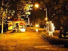
- Tandag Boulevard in Mabua is best visited at night with the colorful lamp posts, windy sea air and various stalls that offer Filipino street food like fish balls, kwek kwek, barbecued pork, isaw, etc.
- Various Grilled Chicken Restaurants line up the Capitol Road between Telaje and Osmena St in Bag-ong Lungsod. From lechon manok to a simple pork barbecue stick, the restaurants here has got you covered for affordable yet yummy meals.
- Capitol Hills in Telaje also offers a good view of the city. The Governor Murillo Sports Complex, the newly renovated Provincial Capitol, Social Hall and the Tennis Court are all located here.
- Muyco's Beach Resort in Mabua is the main beach where plenty of locals flock to especially during the Summer because of its accessibility. If you catch some locals doing skim boarding, try to approach them and learn this new sport. Tandaganons would be delighted to tutor a guest of the city. There are also other nearby beach resorts such as the Parola Beach Resort.
- Located in Haguisan Inn, the heart of the city, is ideal for quiet private dining and get together.
Other notable places of interests
- San Isidro – Busay Falls
- Bioto – Cold Spring
- San Agustin Sur – Beach Resort
- Pangi – Bugsukan Falls & Tagbak stream
- Salvacion – Abaca Plantation
- Quezon – Cave, Falls & Wild Life
- Maticdum – Falls, Water Spring, Cave Forest & Wild Life Conservation
- San Agustin – Norte Beach Resort/Mangroves Prod’n
- Mabuhay – Panugmakan Creek (Potable Water Source) Mt. Resort & Cave
- Dagocdoc – Board Walk (Dike) & Floating Restaurant
- San Antonio – Cold Spring & Beach Resort
- Awasian – Ihawan Mt. Spring Resort/Hitaub IP Gawad Kalinga Project
- Pandanon – Cold Spring
- Rosario – Andap Falls & Spring
- Bag-ong Lungsod – Tandag City Boulevard
- Bongtud – Twin Linungao Island, Mancagangi Island & MPA (Fish Sanctuary)
- Buenavista – MPA ( Fish Sanctuary )
- Buenavista – Mahayag Beach Resort
- Telaje – Floating Restaurant/River Cruise
- Mabua Beach Resort (MPA) – Fish Sanctuary
Transportation
City proper
Accessibility
By air
- via Tandag Airport: From Cebu, you can take direct flight to Tandag and Cebgo ply this route every M-W-F.
- via Francisco Bangoy (Davao) International Airport: From Manila or Cebu to Davao City as transit point, Philippine Airlines, Cebu Pacific and Cebgo ply the Manila-Davao vice versa (approx. 1-1/2 hours travel time) and Cebu-Davao vice versa (approx. 45 minutes travel time) several trips daily.
- via Surigao Airport: From Manila or Cebu to Surigao City as transit point, Cebgo ply these routes daily.
By land
- Multicabs, vans and jeepneys around northern and southern Surigao del Sur routes include Surigao City, San Francisco, Agusan del Sur and Bislig City.
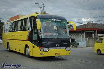
- Buses – direct travel with bus companies like Bachelor Express are serving routes from Davao City, Butuan City, Surigao City, and Mangagoy/Bislig City. Philtranco and PP Bus Line serving Pasay City/Cubao via Cantilan are also available.
- Buses, vans and jeepneys can be located at Tandag City Overland Transport (TCOTT) (Balilahan Bus Terminal).
- Some jeepneys bound for Surigao City, Cantilan, Cortes, Tago, San Miguel, and nearby municipalities and barangays can be found at Moonglow Public Market.
By sea
- Inter-island vessel Cokaliong Shipping Lines ply the Cebu-Surigao City routes on regular schedules with Surigao City Port as transit point. Multi-cabs and tricycles are available at the wharf going to Surigao City Integrated Terminal for the regular bus trips to Tandag.
Hospitals
- Adela Serra Ty Memorial Medical Center (Soon will be a 250 bed D.O.H Tertiary Hospital)
- Medical Mission Group Hospital
- Pama Polyclinic
- Cuartero General Hospital
- Philippine Red Cross Tandag
Education
Basic Education
- Tandag Pilot Elementary School
- Tandag Central Elementary School
- Telaje Elementary School
- Saint Theresa College of Tandag - Basic Education Dept.
- Jacinto P. Elpa National High School
- Tandag National Science High School
- Vicente L. Pimentel Sr. National High School
- Buenavista Nursery School
- Buenavista Elementary School
- Buenavista National High School
- Tandag Christian School
- Surigao del Sur SPED Center
- Tandag Science Elementary School
- Engr. Nestor Ty Memorial Elementary School
- Bongtud Elementary School
- Meliton M. Ajos Memorial Elementary School
- San Jose Elementary School
- Mahanon Elementary School
- Mabuhay Elementary School
- Pandanon Elementary School
- Carmen Integrated School
Baccalaureate
- Saint Theresa College of Tandag - College Dept.
- Surigao del Sur State University - Main Campus
Media
- For desktop users, you may click this link: http://tunein.com/radio/MOR-Davao-1011-s115259/ For Android Smartphones/Tablet/iPhone/iPod users, you may download TuneIn App via Google Play Store or iTunes
- TV-2 - GMA Network
- TV 6 - TNTV (Local News TV)
- TV-8 - PEC Broadcasting Corporation
- TV-23 - TV5 (coming soon)
- TV 26 - ABS-CBN
- Morning Star Cable TV
- Cignal Digital TV
- TETCO
- Globe Broadband
- PLDT Home Bro
- Smart Bro
- TETCO DSL
Sister city
References
- ↑ "Official City/Municipal 2013 Election Results". Intramuros, Manila, Philippines: Commission on Elections (COMELEC). 11 September 2013. Retrieved 1 April 2014.
- 1 2 "Province: SURIGAO DEL SUR". PSGC Interactive. Makati City, Philippines: National Statistical Coordination Board. Retrieved 1 April 2014.
- 1 2 "Total Population by Province, City, Municipality and Barangay: as of May 1, 2010" (PDF). 2010 Census of Population and Housing. National Statistics Office. Retrieved 1 April 2014.
- ↑ https://psa.gov.ph/content/highlights-philippine-population-2015-census-population
- ↑ Virginia Hansen Holmes, Guerrilla Daughter (Kent, Ohio: Kent State U. Press, 2009), pp. 127, 168.
- ↑ Kent Holmes, Wendell Fertig and His Guerrilla Forces in the Philippines: Fighting the Japanese Occupation, 1942-1945 (Jefferson, N.C.: McFarland & Co., 2015), p. 72.
- ↑ Republic Act No. 9392 of 15 March 2007 Charter of the City of Tandag
- ↑ G.R. No. 176951 et al. (First appeal) of 18 November 2008 Consolidated petitions for prohibition assailing the constitutionality of the subject Cityhood Laws and enjoining the Commission on Elections (COMELEC) and respondent municipalities from conducting plebiscites pursuant to the Cityhood Laws.
- ↑ Napallacan, Jhunex (2008-11-21). "Cities' demotion worries DepEd execs". Cebu Daily News. Inquirer.net. Retrieved 15 February 2015.
- ↑ G.R. No. 176951 et al. (First reversal) of 21 December 2009
- 1 2 Republic Act No. 9009 of 24 February 2001 An Act amending section 450 of Republic Act no. 7160, otherwise known as the Local Government Code of 1991, by increasing the average annual income requirement for a municipality or cluster of barangays to be converted into a component city.
- 1 2 G.R. No. 176951 et al. (Second appeal) of 15 February 2011 League of Cities of the Philippines v. COMELEC
- ↑ G.R. No. 176951 et al. (Final Resolution) of 28 June 2011 Supreme Court has directed the Clerk of Court to forthwith issue the Entry of Judgment
- ↑ "Province of Surigao Del Sur". Municipality Population Data. LWUA Research Division. Retrieved 1 April 2014.
- ↑ https://psa.gov.ph/content/highlights-philippine-population-2015-census-population
External links
| Wikimedia Commons has media related to Tandag City. |
| Wikivoyage has a travel guide for Tandag. |
- http://services.inquirer.net/print/print.php?article_id=20110216-320609
- Philippine Standard Geographic Code
- Attractions in and near Tandag
 |
Lanuza / Cortes | | ||
| Bayugan, Agusan del Sur | |
Philippine Sea | ||
| ||||
| | ||||
| San Miguel / Tago |
Tandag (capital) | |
| Municipalities | |
| Component cities | |
