List of heritage sites in Beaufort West
This is a list of the heritage sites in Beaufort West, Western Cape Province, South Africa, as recognized by the South African Heritage Resource Agency.
| SAHRA identifier | Site name | Description | Town | District | NHRA status | Coordinates | Image |
|---|---|---|---|---|---|---|---|
| 9/2/010/0001 | BEAUFORT WEST MUNICIPAL AREA, GENERAL | Beaufort West | Beaufort West | 
| |||
| 9/2/010/0002 | Dutch Reformed Church, 85 Donkin Street, Beaufort West | Neo-Gothic church, cruciform, with square tower at entrance and octagonal spire with clock above.
Lancet windows with cusped arches, sometimes in pairs.
Plasterwork spire, plasterwork around doors and windows, and plasterwork buttress detail.
The building replaced a thatched church.
It was built in 1826-31 and enlarged in 1892-94.
James Bisset was the architect of alterations.
Architectural style: Neo-Gothic.
|
Beaufort West | Beaufort West | Provincial Heritage Site | 32°21′00″S 22°34′59″E / 32.350004°S 22.582950°E | 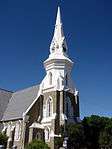 |
| 9/2/010/0002/001 | Cypress tree, Bird Street, Beaufort West | This cypress tree is the only one remaining of about 25 similar trees that were planted in the original Dutch Reformed cemetery in 1834.
|
Beaufort West | Beaufort West | Provincial Heritage Site | 32°20′48″S 22°35′01″E / 32.346648°S 22.583629°E | 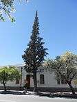 |
| 9/2/010/0003 | Old Town Hall, 87 Donkin Street, Beaufort West | Single-story building with 5 bays. Symmetrical
roof hidden by parapet, and a bracketed cornice.
Hexagonal bell tower over clock above Donkin street entrance.
Windows with shouldered arches.
Rusticated pilasters. The Town Hall of Beaufort West stands in the main street, at the centre of the-historic Karoo town.
It is a striking building, white and massive with bold lines and an old-fashioned tower.
The origins of Beaufort West go back to 1818.
Architectural style: Eclectic.
This building is the first Town Hall of the first Municipality in the country and was built in 1865-1866 by James Bisset. It accommodated the town council, public library, post office, and police station. it is now part of Beaufort West Museum, it houses a display of Prof Chris Barnard, the first doctor to perform a heart transplant. |
Beaufort West | Beaufort West | Provincial Heritage Site | 32°21′02″S 22°34′59″E / 32.350555°S 22.583051°E | 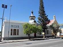 |
| 9/2/010/0004 | Matoppo House, 7 Bird Street, Beaufort West | Single-story building, L-shaped, with 7 bays. Symmetrical.
Pitched roof, with plain end gables and mock-chimneys.
Front wall with plaster paneling and hoods over openings.
Double door with fanlight, French doors and sliding sash windows with Louvre shutters NM 1991.
Second drostdy, for J J Meintjes.
|
Beaufort West | Beaufort West | Provincial Heritage Site | 32°20′48″S 22°35′01″E / 32.346535°S 22.583610°E |  |
| 9/2/010/0005 | see 9/2/010/0009 | Beaufort West | Beaufort West |
| |||
| 9/2/010/0006 | Dutch Reformed Church Parsonage, Merweville, Beaufort West | Beaufort West | Beaufort West | 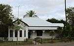 | |||
| 9/2/010/0007 | Old Girls' Public School, Church Street, Beaufort West | Double-story stone building.
Main facade comprises triangular main gable with Palladian windows below; there is a pair of split rectangular gables over each of the other windows.
There are split semi-circular gables over the side windows, which exist in pairs.
Louvred lantern roof ventilator.
Building opened 10 October 1879 but the Girls' Public School opened 15 July 1891.
An east wing for the nursery school was added in 1897 and opened in 1899.
It is a fine example of Victorian public architecture.
|
Beaufort West | Beaufort West | Provincial Heritage Site | 32°21′01″S 22°35′11″E / 32.350160°S 22.586299°E | 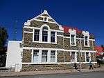 |
| 9/2/010/0008 | Cemeteries, Bird Street, Beaufort West | The original portion of this ring-wall dates from 1857 and was erected when the Nederduitse Gereformeerde (NG) Church cemetery was laid out.
A joint fund-raising campaign by the NG
and the Anglican congregations in 1887 enabled them to extend the ring-wall.
|
Beaufort West | Beaufort West | Provincial Heritage Site | 32°21′28″S 22°35′08″E / 32.357697°S 22.585434°E |  |
| 9/2/010/0009 | Dutch Reformed Church, 161 Church Street, Merweville | Type of site: Church
|
Merweville | Beaufort West | Provincial Heritage Site | 32°40′15″S 21°30′53″E / 32.670913°S 21.514772°E |  |
| 9/2/010/0010 | Anglo-Boer War Blockhouse, Beaufort West | Beaufort West | Beaufort West |
| |||
| 9/2/010/0011 | Masonic Hotel, 94 Donkin Street, Beaufort West | Beaufort West | Beaufort West | 32°21′17″S 22°35′00″E / 32.354738°S 22.583435°E |
| ||
| 9/2/010/0012 | Clyde House, 37 Donkin Street, Beaufort West | Double-story building with hipped roof. 3 bays, symmetrical.
Double verandah, plain roof, returned, with plenty of ornamental cast-iron detail.
Hoods and keystones above windows.
Front door 6 panels, leaded fanlight, stained glass.
Sliding sash windows.
Multicoloured front door. Built in 1839 for Dr James Christie, first full-time government doctor in the area.
He was also town councillor, MP & director of Beaufort Bank.
The building served as a police station 1898 till after the Anglo-Boer War.
|
Beaufort West | Beaufort West | Provincial Heritage Site | 32°20′47″S 22°34′56″E / 32.346279°S 22.582346°E | 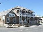 |
| 9/2/010/0013 | Old Central High School, Beaufort West | Beaufort West | Beaufort West |
| |||
| 9/2/010/0014 | Corbelled hut, Vleifontein, Laingsburg | Corbelled drystone dwelling (nat mon) said to be the southernmost example.
It has a kookskerm.
Other structures
Extensive drystone kraals on both sides of valley Harmse family massacre on N side of valley, opposite corbelled dwelling
When vacated:
|
Beaufort West | Provincial Heritage Site | 32°09′21″S 22°01′14″E / 32.155772°S 22.020642°E |
| |
| 9/2/010/0015 | Little Green World, 38 Donkin Street, Beaufort West | Beaufort West | Beaufort West | 32°20′50″S 22°34′56″E / 32.347128°S 22.582354°E |
| ||
| 9/2/010/0016 | Old Public Library, 15 Kerk Street, Beaufort West | A somewhat ponderous version of the eclectic style.
Triangular pediment, horizontal and raking cornices, semi-circular cap on pediment, with rustication to windows and gable ventilator.
Porch on Ionic columns.
This impressive Edwardian building, with its neoclassical features, was erected by Matthew Deas, master-builder of Beaufort West.
The front gable bears the date 1906.
|
Beaufort West | Beaufort West | Provincial Heritage Site | 32°19′07″S 22°34′25″E / 32.318610°S 22.573600°E | 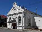 |
| 9/2/010/0017 | Dutch Reformed Mission Church and Parsonage, 89/91 Donkin Street. | Beaufort West | Beaufort West | 32°20′53″S 22°34′57″E / 32.348066°S 22.582474°E | 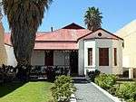 | ||
| 9/2/010/0017/001 | Old Dutch Reformed Mission Church Parsonage, 91 Donkin Street, Beaufort West | S/s villa, hipped roof, triangular louvred ventilators, projecting wing on R with covered end gable & bay window with 3 shuttered sash windows.
Verandah roof on timber posts, wooden brackets & pendants, balustrade The early nineteenth century parsonage was enlarged in 1914 by the Rev. A.H. Barnard and was the birthplace of the well-known heart surgeon, Prof
Chris Barnard and his brother Dr Marius Barnard.
|
Beaufort West | Beaufort West | Provincial Heritage Site | 32°21′03″S 22°35′00″E / 32.350820°S 22.583254°E | |
| 9/2/010/0017/002 | Old Dutch Reformed Mission Church, 89 Donkin Street, Beaufort West | Church, end gable with raking cornice & belfry faces street, twin lancet windows over entrance porch.
Nave 4 bays, buttresses. Lancet windows, pointed hoods, with coloured diamond panes, original wooden tracery (?). Rough-cast walls, stone plinth. This Mission Church, the foundation stone of which was laid on 4 May 1871, was completed in December 1872 by the building contractor Adriaan Ventura. The Rev. Paulus Teshe was the main driving force behind its erection. Architectural style: Cape Neo-Gothic.
|
Beaufort West | Beaufort West | Provincial Heritage Site | 32°21′03″S 22°34′59″E / 32.350728°S 22.583018°E | 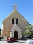 |
| 9/2/010/0017/1 | Old Dutch Reformed Mission Church Parsonage, 91 Donkin Street, | Beaufort West | Beaufort West | National Monument | 32°20′53″S 22°34′57″E / 32.348066°S 22.582474°E |
| |
| 9/2/010/0018 | Pear trees, Donkin Street, Beaufort West | 2 Very old pear trees on pavement.
One near Ye Olde Thatch died.
Other one at Pritchard's Bldg.
These pear trees were planted in 1850 and 1860.
|
Beaufort West | Beaufort West | Provincial Heritage Site | 32°21′24″S 22°35′01″E / 32.356528°S 22.583735°E | 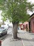 |
| 9/2/010/0019 | Pritchard Building, 92 Donkin Street, Beaufort West | Beaufort West | Beaufort West | 32°20′53″S 22°34′57″E / 32.348058°S 22.582479°E |
| ||
| 9/2/010/0020 | Grave of W A Arnot, Merweville, Beaufort West District | Beaufort West | Beaufort West |
| |||
| 9/2/010/0021 | Poskoetshuis, 111 Bird Street, Beaufort West | Beaufort West | Beaufort West | 32°20′49″S 22°35′01″E / 32.347023°S 22.583707°E |
| ||
| 9/2/010/0022 | Beaufort West East Dutch Reformed Mission Church, Beaufort West | Beaufort West | Beaufort West |
| |||
| 9/2/010/0023 | Christ Church complex, Donkin Street, Beaufort West | Beaufort West | Beaufort West | 32°20′45″S 22°34′57″E / 32.3459194°S 22.5824806°E |
| ||
| 9/2/010/0024 | Methodist cemetery, Beaufort West | Beaufort West | Beaufort West |
| |||
| 9/2/010/0026 | Military Cemetery, Nelspoort, Beaufort West District | Beaufort West | Beaufort West |
| |||
| 9/2/010/0027 | BEAUFORT WEST MAGISTERIAL DISTRICT, GENERAL | Beaufort West | Beaufort West |
| |||
| 9/2/010/0028 | Catholic Cemetery, Thompson Street, Beaufort West | Beaufort West | Beaufort West |
| |||
| 9/2/010/0029 | Droer Rivier (Eskom Sub-station), Beaufort West District. | Beaufort West | Beaufort West |
| |||
| 9/2/010/0030 | Hillmore, Vetkuil 332, Beaufort West District | Beaufort West | Beaufort West |
| |||
| 9/2/010/0031 | Guards Memorial, Farm Brak Pannen, Beaufort West District | Beaufort West | Beaufort West |
| |||
| 9/2/010/0032 | KAROO NATIONAL PARK, BEAUFORT WEST DISTRICT | Beaufort West | Beaufort West |
|
References
| Wikimedia Commons has media related to Cultural heritage monuments in Western Cape. |
Lists of South African Heritage Resources | ||||||||||||||||||||||||||||||||||||
|---|---|---|---|---|---|---|---|---|---|---|---|---|---|---|---|---|---|---|---|---|---|---|---|---|---|---|---|---|---|---|---|---|---|---|---|---|
| SAHRA Heritage sites |
| |||||||||||||||||||||||||||||||||||
| World heritage sites | ||||||||||||||||||||||||||||||||||||