List of heritage sites in Swellendam and Riversdale
This is a list of the heritage sites in Swellendam and Riversdale, situated in the Western Cape, as recognized by the South African Heritage Resources Agency.[1]
| SAHRA identifier | Site name | Description | Town | District | NHRA status | Coordinates | Image |
|---|---|---|---|---|---|---|---|
| 9/2/079/0001 | Zeekoegat, Riversdale District | The Groote Wagen Weg or main wagon road from Swellendam to the east crossed the Buffelsjachts, Duivenhoks, Kafferkulls and the Gouritz Rivers.
Even as early as 1750 there were several farmers living on farms along this road; one of them was Michael Muller
|
Riversdale | Provincial Heritage Site | 34°03′48″S 21°15′16″E / 34.063454°S 21.254371°E | 
| |
| 9/2/079/0002 | Jagersbosch, Still Bay, Riversdale District | A single storey white washed farm house with thick walls and a saddle roof with straight end gable The roof was originally thatched but on one side the thatch has been replaced by asbestos sheeting.
The one end has an external masonry staircase to the lof This farm belonged to the De Jager Family, who also owned Palingsgat (Palingsfontein, Palingshuis) which was built in 1809 and rebuilt in 1814 after having been burnt down.
One of the five sons of the original owner to Palingsgat built a bigger house on t
|
Riversdale | Provincial Heritage Site | 34°22′02″S 21°25′03″E / 34.367146°S 21.417570°E |
| |
| 9/2/079/0003 | Kleinfontein, Duiwehoks River, Riversdale District | H-shaped Cape Dutch house
|
Riversdale | Provincial Heritage Site | 34°05′53″S 21°15′47″E / 34.098048°S 21.262922°E |
| |
| 9/2/079/0004 | Old Toll House, Garcia Pass, Riversdale District | This old toll-house, situated within the Kristalkloof Forest Reserve, is still in a very good state of preservation and stands, as it were, on an island between the old road passing in front of it and the new road passing behind it.
A few old and tall cyp The pass was named in honour of the Commissioner of Riversdale at that time, A.H. Garcia.
He himself went to investigate the feasibility of a road through the mountains and in 1872 the Cape Parliament decided that Garcia Pass would be constructed by conv
|
Riversdale | Provincial Heritage Site | 33°57′18″S 21°13′33″E / 33.955055°S 21.225787°E | 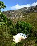 | |
| 9/2/079/0005 | Palingsgat Farmstead, Plattebosch, Still Bay, Riversdale District | Type of site: Farm Complex | Riversdale | Provincial Heritage Site | 34°05′50″S 21°15′43″E / 34.097338°S 21.261892°E |
| |
| 9/2/079/0006 | Masonic Lodge Frere and Hall, 10 Long Street, Riversdale | Type of site: Masonic Hall, Masonic Lodge | Riversdale | Riversdale | Provincial Heritage Site | 34°05′21″S 21°15′43″E / 34.089142°S 21.262060°E |
|
| 9/2/079/0007 | Puntjie, 'Kapstylhuisies', Kleinfontein Farm, Riversdale District | Puntjie is an unintentional open-air museum of nearly seventy kapstylhuise (truss-style houses) or as they are called in that area, hartbeeshuisies
The Kapstylhuis, as its name suggests, consists solely of a roof carried on a series of about eight couple Puntjie is a portion of the farm Kleinfontein.
In the course of time fishermen and holidaymakers erected tents and later kapstylhuisies here without the consent of successive owners and often to their considerable annoyance.
When Mr.
Danie Hoffmann, who w
|
Riversdale | Provincial Heritage Site | 34°05′46″S 21°15′17″E / 34.096009°S 21.254768°E | 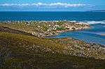 | |
| 9/2/079/0010 | RIVERSDALE MUNICIPAL AREA, GENERAL | Riversdale | Riversdale | Pending Declaration |
| ||
| 9/2/079/0011 | Arcadia, Stilbaai, Riversdale District | Still Bay | Riversdale |
| |||
| 9/2/079/0012 | STILL BAY MUNICIPAL AREA, RIVERSDALE DISTRICT, GENERAL | Still Bay | Riversdale |
| |||
| 9/2/079/0012-001 | Die Rondawel and Die Wit Huisie, Strand Street, Jongensfontein, Riversdale District | Jongensfontein | Riversdale | Register | 34°25′48″S 21°20′08″E / 34.429966°S 21.335437°E |
| |
| 9/2/079/0013 | ALBERTINIA MUNICIPAL AREA, RIVERSDALE DISTRICT, GENERAL | Albertinia | Riversdale |
| |||
| 9/2/079/0014 | Garcia State Forest, Riversdale District | Riversdale | Riversdale | 33°57′21″S 21°12′01″E / 33.955942°S 21.200368°E |
| ||
| 9/2/079/0015 | Versveld House, Long Street, Riversdale | This predominantly Georgian house was erected by Dirk Versfeld (1853-1912) shortly after 1882 and donated to the City Council of Riversdale by his son, Theodore, to house the Julius Gordon art collection.
The building was restored in 1965 and converted in |
Riversdale | Riversdale | Provincial Heritage Site | 34°05′58″S 21°16′03″E / 34.099397°S 21.267499°E | 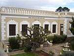 |
| 9/2/079/0016 | St Matthews Anglican Church, Riversdale | Riversdale | Riversdale | National Monument |
| ||
| 9/2/079/0017 | Beach cottages, Stilbaai, Riversdale District | Still Bay | Riversdale | Pending Declaration |
| ||
| 9/2/079/0017/1 | Beach cottages, Stilbaai East, Riversdale District | Still Bay | Riversdale |
| |||
| 9/2/079/0017/2 | Beach cottages, Stilbaai West, Riversdale District | Still Bay | Riversdale |
| |||
| 9/2/079/0018 | RIVERSDALE MAGISTERIAL DISTRICT, GENERAL | Riversdale | Riversdale |
| |||
| 9/2/079/0019 | GOURITSMOND MUNICIPAL AREA, GENERAL, RIVERSDALE | Gouritsmond | Riversdale |
| |||
| 9/2/079/0020 | Fish Traps, Rein's Nature Reserve, Farm Buffelshoek 455, Riversdale | Riversdale | Riversdale |
| |||
| 9/2/092/0001 | Old St Luke's School, 74-76 Voortrek Street, Swellendam | Mid 19th century, single storied, flat roofed building with handsome cornice. Reused as the school to children of Congregation using St. Luke's. School building and adjacent St. Lukes make a contrasting and historical pair. Very important. Type of site: School Previous use: School. Current use: Offices. | Swellendam | Swellendam | Provincial Heritage Site | 34°01′13″S 20°26′39″E / 34.020398°S 20.444153°E | 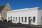 |
| 9/2/092/0002 | Voortrekkersaal, Swellendam | Swellendam | Swellendam | National Monument |
| ||
| 9/2/092/0003 | Stormsvlei Complex, Swellendam District | Swellendam | Swellendam | 34°05′01″S 20°05′50″E / 34.083486°S 20.097327°E |
| ||
| 9/2/092/0004 | SWELLENDAM MUNICIPAL AREA, GENERAL | Swellendam | Swellendam | Pending |
| ||
| 9/2/092/0005 | Rheenendal Mill, Swellendam District | This mill-house consists of a double-storeyed Georgian building which dated from about 1880 and is closely associated with the development of industrial architecture in South Africa. The mill-wheel is of the overshot type. Type of site: Mill Previous use: Mill. This mill-house consists of a double-storeyed Georgian building which dated from about 1880 and is closely associated with the development of industrial architecture in South Africa. The mill-wheel is of the overshot type. | Swellendam | Provincial Heritage Site | 34°02′21″S 20°26′22″E / 34.039254°S 20.439377°E |
| |
| 9/2/092/0006 | Mission core, The Braak, Suurbrak | Suurbraak | Swellendam | Provisional Protection | 34°01′00″S 20°39′00″E / 34.016667°S 20.650000°E | 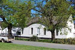 | |
| 9/2/092/0007 | Mill Cottage, 243 Voortrek Street, Swellendam | Swellendam | Swellendam | Provincial Heritage Site | 34°02′12″S 20°25′33″E / 34.036716°S 20.425871°E |
| |
| 9/2/092/0008 | Church Square, Swellendam | Type of site: Square. | Swellendam | Swellendam | Provincial Heritage Site | 34°01′13″S 20°26′42″E / 34.020222°S 20.444885°E |  |
| 9/2/092/0009 | Moolmanshof, 217 Voortrek Street, Swellendam | The oldest portion of this impressive dwelling-house was erected in 1798 by Christiaan Essenberg, an immigrant from Switzerland. The house was enlarged in the 1840s by I. Z. Moolman and named Moolmanshof. It is one of the oldest buildings in Swellendam. | Swellendam | Swellendam | Provincial Heritage Site | 34°02′04″S 20°25′42″E / 34.034453°S 20.428210°E |
|
| 9/2/092/0010 | "La Bella Alliance", Swellengrebel Street, Swellendam | Swellendam | Swellendam | National Monument | 34°01′02″S 20°26′59″E / 34.017212°S 20.449821°E |
| |
| 9/2/092/0011 | Bukkenburg House, 8 Hermanus Steyn Street, Swellendam | This late nineteenth century dwelling, with its predominantly Victorian features, forms an integral part of the historic core of Swellendam in the immediate vicinity of the Drostdy. | Swellendam | Swellendam | Provincial Heritage Site | 34°01′09″S 20°27′04″E / 34.019129°S 20.451167°E |  |
| 9/2/092/0012 | Die Tuishuise, 2-4 Shand Street, Swellendam | Across the main road from the Auld House in Swellendam there is a very interesting historical group - a small square, a row of tuishuise or farmers’ town houses and The Cottage.
The peaceful square with ancient oaks along three sides of it, is old. It pro. Die Tuishuise were built about the middle of the nineteenth century by distinguished residents of Swellendam and are of considerable architectural importance. |
Swellendam | Swellendam | Provincial Heritage Site | 34°01′00″S 20°26′51″E / 34.016622°S 20.447457°E |
|
| 9/2/092/0013 | Homestead, Klip River 192, Swellendam District | During the years 1833-1837 the farm Kliprivier was owned by Marthinus Steyn, great grandfather of President M T Steyn and the builder of the magnificent homestead. The farm was also owned by President F W Reitz during the years 1869-1899. During the years 1833-1837 the farm Kliprivier was owned by Marthinus Steyn, great grandfather of President M T Steyn and the builder of the magnificent homestead. The farm was also owned by President F W Reitz during the years 1869-1899. | Swellendam | Provincial Heritage Site | 34°01′50″S 20°26′16″E / 34.030594°S 20.437660°E |
| |
| 9/2/092/0014 | Charcoal kiln, Voorhuis, Swellendam District | This charcoal oven was built about the middle of the 18th century by Hermanus Steyn and is the oldest known structure of its kind in South Africa. Type of site: Charcoal kiln. This charcoal oven was built about the middle of the 18th century by Hermanus Steyn and is the oldest known structure of its kind in South Africa. | Swellendam | Provincial Heritage Site | 34°01′32″S 20°26′22″E / 34.025597°S 20.439377°E |
| |
| 9/2/092/0015 | 241 Voortrek Street, Swellendam | Swellendam | Swellendam | National Monument | 34°02′12″S 20°25′35″E / 34.036558°S 20.426325°E |
| |
| 9/2/092/0016 | 198 Voortrek Street, Swellendam | Swellendam | Swellendam | 34°01′38″S 20°26′05″E / 34.027269°S 20.434716°E |
| ||
| 9/2/092/0017 | 27 Berg Street, Swellendam | These four dwelling-houses with their Victoria characteristics all date from the nineteenth century or the first decade of the twentieth century and form an integral part of the historical and architectural core of Swellendam. | Swellendam | Swellendam | Provincial Heritage Site | 34°00′56″S 20°27′15″E / 34.015523°S 20.454039°E |
|
| 9/2/092/0018 | Kinkoe Farm, Swellendam | Swellendam | Swellendam | National Monument | 34°06′38″S 20°34′39″E / 34.110476°S 20.577605°E |
| |
| 9/2/092/0019 | 14 Drostdy Street, Swellendam | The core of this Victorian house, originally erected in the Cape Dutch style, dates from the eighteenth century. The house was, however, extensively Victorianised during the mid-nineteenth century by raising the roof level considerably and the addition of The core of this victorianised house, originally in the Cape Dutch style, dates from the Eighteenth Century and was reputedly the stable, coach-house and saddler's dwelling serving the Drostdy complex. The core of this victorianised house, originally in the Cape Dutch style, dates from the Eighteenth Century and was reputedly the stable, coach-house and saddler's dwelling serving the Drostdy complex. | Swellendam | Swellendam | Provincial Heritage Site | 34°01′16″S 20°27′06″E / 34.020996°S 20.451592°E |
|
| 9/2/092/0020 | Conniston, 21 Van Oudtshoorn Road, Swellendam | Swellendam | Swellendam | National Monument | 34°00′58″S 20°26′55″E / 34.016183°S 20.448504°E |
| |
| 9/2/092/0021 | Hope Lodge, 218 Voortrek Street, Swellendam | These four dwelling-houses with their Victorian characteristics all date from the nineteenth century or the first decade of the twentieth century and form an integral part of the historical and architectural core of Swellendam. | Swellendam | Swellendam | Provincial Heritage Site | 34°01′47″S 20°25′57″E / 34.029590°S 20.432432°E |
|
| 9/2/092/0022 | Auld House, 4 Voortrek Street, Swellendam | A short way above the "Oefeninghuis" in the main street of Swellendam stands a fine Cape house with white gables and a thatched roof. It is the spiritual home of the Barry family in South Africa.
The name of Joseph Barry is legendary in the history of the. The "Auld House" is a particularly fine old Cape house with interesting associations with the historic Barry family. |
Swellendam | Swellendam | Provincial Heritage Site | 34°01′03″S 20°26′52″E / 34.017485°S 20.447814°E | 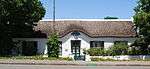 |
| 9/2/092/0023 | The Glen, Glen Barry Road, Swellendam | The property on which this Cape Dutch house is situated was originally granted to Johannes Matthys Ebersohn in 1799 who initially erected a T-shaped house. Jan Ferdinand Bam converted it into an H-shaped house early in the nineteenth century. The property on which this Cape Dutch house is situated was originally granted to Johannes Matthys Ebersohn in 1799 who initially erected a T-shaped house. Jan Ferdinand Bam converted it into an H-shaped house early in the nineteenth century. | Swellendam | Swellendam | Provincial Heritage Site | 34°00′39″S 20°27′04″E / 34.010945°S 20.451232°E |
|
| 9/2/092/0024 | Dwelling, cnr Van Riebeeck & Tilney Streets, Barrydale, Swellendam | Barrydale | Swellendam | National Monument | 33°54′08″S 20°43′25″E / 33.902210°S 20.723656°E |
| |
| 9/2/092/0025 | 10 Trichard Street, Swellendam | Swellendam | Swellendam | Pending | 34°01′18″S 20°26′42″E / 34.021593°S 20.445077°E |
| |
| 9/2/092/0026 | JVDS House, 266/268 Voortrek Street, Swellendam | JVDS house, gable date 1834. Also one of the Rothman properties. Known as Rothman House. Early 19th century T-shaped house in excellent condition. Also adjacent cottage. Property is of considerable architectural, historical and environmental importance cu Type of site: House Current use: House. | Swellendam | Swellendam | Provincial Heritage Site | 34°02′12″S 20°25′37″E / 34.0365361111°S 20.426994°E | 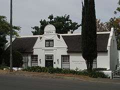 |
| 9/2/092/0027 | 9 Moolman Street, Swellendam | This, is a mid-nineteenth-century building complex consisting of a self-contained dwelling at each end and joined by a row of three rooms. All are on different levels, it has been consolidated into one dwelling by means of minor internal alterations. All. This mid-nineteenth century structure consists of two self-contained units joined by a row of three rooms in the centre. It was reputedly part of a row of "tuishuisies" near the Dutch Reformed Church. | Swellendam | Swellendam | Provincial Heritage Site | 34°01′37″S 20°25′56″E / 34.026873°S 20.432301°E |
|
| 9/2/092/0028 | Old Drostdy, 2 Drostdy Street, Swellendam | The Heemraad chose an excellent site for their Drostdy. It is situated to the east of the Korenlands River, on the road to the Cape and commands a fine view across the valley to the Langeberg Range and the towering Twelve O’Clock Peak. Building of the Dro Type of site: Drostdy. | Swellendam | Swellendam | Provincial Heritage Site | 34°01′11″S 20°27′12″E / 34.019587°S 20.453249°E |  |
| 9/2/092/0029 | Dutch Reformed Church, 11 Voortrek Street, Swellendam | Type of site: Church Current use: Church : Dutch Reformed. The corner-stone of this building was laid on 25 November 1910. The church with its diversity of architectural syles was officially inaugurated on 10 June 1911 by Prof. C F J Muller. The decorated entrance archway and gates are the only remains of the ear | Swellendam | Swellendam | Provincial Heritage Site | 34°01′04″S 20°26′47″E / 34.017880°S 20.446428°E | 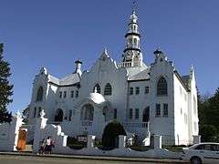 |
| 9/2/092/0029/1 | Arch and gate, Voortrek Street, Swellendam | Swellendam | Swellendam | National Monument |
| ||
| 9/2/092/0030 | Rose Cottage, 245 Voortrek Street, Swellendam | This double-storeyed rectangular house, dating from about 1840, was presumably built by W M Hopley, a well-known local land surveyor. | Swellendam | Swellendam | Provincial Heritage Site | 34°02′13″S 20°25′32″E / 34.036912°S 20.425602°E |
|
| 9/2/092/0031 | Schoone Oordt, 1 Swellengrebel Street, Swellendam | This double-storeyed house was built in 1853 in the Cape Georgian style and victorianised in the late-nineteenth century by the addition of a cast-iron verandah on both levels. The outbuildings, consisting of the original coach house and what is believed. | Swellendam | Swellendam | Provincial Heritage Site | 34°01′02″S 20°26′59″E / 34.017207°S 20.449814°E, 1 Swellengrebel Street, Swellendam)] | 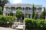 |
| 9/2/092/0032 | 10 Moolman Street, Swellendam | This cottage, which is predominantly in the Cape vernacular style, dates from the middle of the nineteenth century. | Swellendam | Swellendam | Provincial Heritage Site | 34°01′37″S 20°25′59″E / 34.026867°S 20.432975°E |
|
| 9/2/092/0033 | Rotterdam, Swellendam District | The farm Rotterdam, which was granted to Hendrik van Vollenhoven by Governor J. H. van Plettenberg in 1783, was transferred to Landdrost Anthonie Faure in 1794. The main homestead, the Baroque front gable of which bears the date 1794, was erected by him. | Swellendam | Provincial Heritage Site | 34°01′32″S 20°26′10″E / 34.025577°S 20.435987°E |
| |
| 9/2/092/0034 | Park Villa, 23 Van Oudtshoorn Street, Swellendam | Type of site: House. This house was originally a T-shaped Cape Dutch building that was erected about 1802. It was subsequently Victorianised, but still retained many Cape Dutch features. | Swellendam | Swellendam | Provincial Heritage Site | 34°00′59″S 20°26′54″E / 34.016523°S 20.448215°E |
|
| 9/2/092/0035 | 9 Siebert Street, Swellendam | These four dwelling-houses with their Victoria characteristics all date from the nineteenth century or the first decade of the twentieth century and form an integral part of the historical and architectural core of Swellendam. | Swellendam | Swellendam | Provincial Heritage Site | 34°01′23″S 20°26′35″E / 34.022967°S 20.443019°E |
|
| 9/2/092/0036 | Old Gaol, 24, 26, 28 Swellengrebel Street, Swellendam | The building which, after so many years, is still called the Old Gaol is second only to the Drostdy, as the oldest and most interesting building in Swellendam.
The oldest known drawing of the Drostdy complex drawn by Schumacher in 1776, shows the gaol alr Type of site: Gaol. |
Swellendam | Swellendam | Provincial Heritage Site | 34°01′07″S 20°27′09″E / 34.018635°S 20.452565°E | 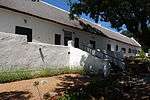 |
| 9/2/092/0037 | Old Post Office, 22 Swellengrebel Street, Swellendam | Diagonally opposite the Drostdy and immediately next to the Old Gaol, there is a small house with a thatched roof and thick walls. High up in the heavy yellow-wood front door there is a slot for receiving letters. This little building, still known as the Old Post Office was the residence of the gaoler.
In the earliest days of the postal service at the Cape, the salary of a postmaster was so small that the appointment was held by someone who also performed some othe Type of site: Post Office Previous use: Post office. |
Swellendam | Swellendam | Provincial Heritage Site | 34°01′07″S 20°27′09″E / 34.0185472222°S 20.452397°E |  |
| 9/2/092/0038 | Oak trees, Swellengrebel Street, Swellendam | Swellengrebel Street which passes in front of the Drostdy is a part of the original Cape Wagon Road or Groote Wagenweg, the route of the earliest expeditions into the interior. It presumably already existed when the Drostdy was built in 1746. Where there Type of site: Tree. | Swellendam | Swellendam | Provincial Heritage Site | 34°01′17″S 20°26′31″E / 34.021508°S 20.441893°E |
|
| 9/2/092/0039 | The Oefeninghuis, 36 Voortrek Street, Swellendam | Swellendam, one of the oldest towns in South Africa, holds a particular fascination for visitors. This may be due to the fact that many of the original houses in the main street in the older part of the town are still standing and thus preserve something. | Swellendam | Swellendam | Provincial Heritage Site | 34°01′09″S 20°26′45″E / 34.019042°S 20.445747°E |  |
| 9/2/092/0040 | The Cottage, 5 Voortrek Street, Swellendam | The Cottage is a worthy T -shaped old Cape house, probably built in 1832.
Across the main road from the Auld House in Swellendam there is a very interesting historical group - a small square, a row of tuishuise or farmers’ town houses and The Cottage. Th. "The Cottage" is a worthy T-shaped old Cape house, probably built in 1832. |
Swellendam | Swellendam | Provincial Heritage Site | 34°01′01″S 20°26′52″E / 34.016885°S 20.447790°E |  |
| 9/2/092/0041 | Dutch Reformed Church, Malgas, Swellendam District | This attractive stone church dates from the middle of the nineteenth century when Malgas was a flourishing inland harbour on the Breede River. Type of site: Church Current use: Church : Dutch Reformed. | Swellendam | Provincial Heritage Site | 34°01′14″S 20°27′00″E / 34.020479°S 20.449880°E |
| |
| 9/2/092/0042 | Old Residency, 12 Van Oudtshoorn Road, Swellendam | The property was granted to Thomas Barry in 1839, who apparently built the house without delay. Later it became the residence of the magistrate and was known as the Residency. It has recently been purchased and restored by Historical Homes Limited.
Swell Type of site: Residency. The property was granted to Thomas Barry in 1839, who apparently built the house without delay. Later it became the residence of the magistrate and was known as the Residency. It has recently been purchased and restored by Historical Homes Limited. |
Swellendam | Swellendam | Provincial Heritage Site | 34°00′52″S 20°26′59″E / 34.014536°S 20.449736°E |  |
| 9/2/092/0043 | Old High School for Boys, 147 Voortrek Street, Swellendam | Situated against the slope, it commanded a view of the entire valley and the beautiful frontal aspect must have been impressive. In fact, it still is. A double flight of steps leads to the huge front-door with its fanlike fanlight. The land on which this H-shaped house is situated was granted to Jacobus Wessel van Dijk in 1818. He was one of the well-known wainwrights of Swellendam and built the house round 1825.
In 1839 Van Dijk sold the property and several Wainwrights owned the Type of site: School Previous use: School. The land was granted in 1818 to J W van Dyk, a wagonmaker who built the house in about 1825. There was a wagon-builder's workshop in the basement up to 1870. The building was then purchased for a school and Dr D F Malan taught there in 1896. It has been r |
Swellendam | Swellendam | Provincial Heritage Site | 34°01′38″S 20°26′02″E / 34.027097°S 20.433831°E | 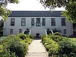 |
| 9/2/092/0044 | 18 Swellengrebel Street, Swellendam | This land formed part of the original Drostdy property which was subdivided in 1799. The house is a Georgian double-storeyed building dating from the middle of the last century and is architecturally outstanding. This land formed part of the original Drostdy property which was subdivided in 1799. The house is a Georgian double-storeyed building dating from the middle of the last century and is architecturally outstanding. | Swellendam | Swellendam | Provincial Heritage Site | 34°01′06″S 20°27′07″E / 34.018222°S 20.451991°E | 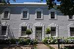 |
| 9/2/092/0045 | Morgenzon, 16 Van Oudtshoorn Drive, Swellendam | This U-shaped Cape Dutch house was erected in about 1745 as dwelling for the Secretary of the local Drostdy. From 1855 to 1875 it was used as an exclusive school for girls. This U-shaped Cape Dutch house was erected in about 1745 as dwelling for the Secretary of the local Drostdy. From 1855 to 1875 it was used as an exclusive school for girls. | Swellendam | Swellendam | Provincial Heritage Site | 34°00′57″S 20°26′59″E / 34.015714°S 20.449711°E |
|
| 9/2/092/0046 | Mayville, 4 Hermanus Steyn Street, Swellendam | This property is situated on land which originally formed part of the historical Drostdy complex in Swellendam. The house was built about 1853 for the owner, Daniël de Bruyn. Type of site: House Previous use: Residential. Current use: Museum. The property is situated on land which originally formed part of the historical Drostdy complex in Swellendam. The house was built about 1853 for the owner, Daniel de Bruyn. | Swellendam | Swellendam | Provincial Heritage Site | 34°01′07″S 20°27′03″E / 34.018725°S 20.450970°E | 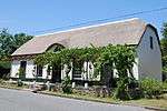 |
| 9/2/092/0047 | Old Powder Magazine, 9 Gelderblom Street, Swellendam | Swellendam was still a fairly remote outpost of civilisation at the beginning of the 19th century. The inhabitants of the district strongly opposed the administration at the Cape, and this resulted in much dissatisfaction and even open revolt.
A vital co Type of site: Powder Magazine Previous use: Powder magazine. This simple rectangular powder magazine dates from the middle of the nineteenth century and was possibly erected by the well-known firm, Barry and Nephews. The property was owned by Cornelius Human, well known character that owned Human's Garage in town in the mid 20th century up to 1948. Before and during WWII he used it for aircraft fuel storage as he was the appointed supplier of fuel at the air strip which is in the Bontebok Park today. Both his children were born in the house, and I am one of them! - Piet Human. On the day we buried our mother in Swellendam, I visited this property and was surprised to see that the outbuilding is now a national monument - with an upside down mounted commission plaque! |
Swellendam | Swellendam | Provincial Heritage Site | 34°01′02″S 20°26′41″E / 34.017171°S 20.444678°E | 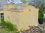 |
| 9/2/092/0048 | 11 Van Oudtshoorn Drive, Swellendam | This dwelling-house, with its Victorian and Edwardian features, dates from the first decade of the twentieth century. | Swellendam | Swellendam | Provincial Heritage Site | 34°00′52″S 20°26′56″E / 34.014526°S 20.448968°E |
|
| 9/2/092/0049 | 5 Buitenkant Street, Swellendam | This predominantly Victorian dwelling-house, with its bay window at one end and veranda stretching on two sides of the building, was erected in 1900 by a local buildier named Karg. | Swellendam | Swellendam | Provincial Heritage Site | 34°01′26″S 20°26′05″E / 34.023982°S 20.434817°E |
|
| 9/2/092/0050 | 3 Moolman Street, Swellendam | This cottage originally formed part of a row of nineteenth century buildings situated in Moolman Street. Some of these structures have unfortunately been demolished. The cottage originally consisted of a single row of rooms with a flat-roofed addition to. This cottage in the vernacular style was reputedly one of a row of nineteenth century "tuishuisies" near the Dutch Reformed Church. | Swellendam | Swellendam | Provincial Heritage Site | 34°01′33″S 20°25′53″E / 34.025812°S 20.431406°E |
|
| 9/2/092/0051 | Klein Drostdy, 12 Drostdy Street, Swellendam | Type of site: Drostdy. This dwelling-house with its Cape-Georgian characteristics, which date from the 1850's, forms an integral part of the historical core of Swellendam. | Swellendam | Swellendam | Provincial Heritage Site | 34°01′15″S 20°27′07″E / 34.020757°S 20.451996°E |
|
| 9/2/092/0052 | Lismore, Swellendam District | The farm Lismore has been in the Barry family for five generations and the homestead has never been changed since it came into their possession. The homestead consists of a T-shaped house with two minor extensions on each end of the facade. The house is l. The core of this Cape Dutch homestead dates from the 1750s. Additions were made in the 1840s, after which it remained unaltered. Since then, Lismore has been in the possession of the Barry family for five generations. | Swellendam | Provincial Heritage Site | 34°01′22″S 20°26′20″E / 34.022660°S 20.438991°E |
| |
| 9/2/092/0053 | 10 Hermanus Steyn Street, Swellendam | These four dwelling-houses with their Victoria characteristics all date from the nineteenth century or the first decade of the twentieth century and form an integral part of the historical and architectural core of Swellendam. | Swellendam | Swellendam | Provincial Heritage Site | 34°01′09″S 20°27′03″E / 34.019144°S 20.450870°E |
|
| 9/2/092/0054 | 204 Voortrek Street, Swellendam | The property on which this late-nineteenth-century dwelling-house is situated originally formed part of the old Boys’ High School (now Olyfkrans College). The house forms an integral part of the architectural character of Voortrek Street in Swellendam. | Swellendam | Swellendam | Provincial Heritage Site | 34°01′40″S 20°26′01″E / 34.027770°S 20.433692°E |
|
| 9/2/092/0055 | 101 Voortrek Street, Swellendam | This nineteenth century dwelling, with its predominantly Victorian characteristics, forms an integral part of the architectural street scene of Voortrek Street and of the historic core of Swellendam. | Swellendam | Swellendam | Provincial Heritage Site | 34°01′26″S 20°26′18″E / 34.023755°S 20.438211°E |  |
| 9/2/092/0056 | Malta, 9 Glen Barry Road, Swellendam | Swellendam | Swellendam | Provincial Heritage Site | 34°00′44″S 20°26′58″E / 34.012288°S 20.449393°E |
| |
| 9/2/092/0057 | St Luke's Church, 72 Voortrek Street, Swellendam | Building of considerable period character, now well restored. A landmark in Swellendam. Type of site: Church Current use: Church : Anglican. | Swellendam | Swellendam | Provincial Heritage Site | 34°01′13″S 20°26′40″E / 34.020196°S 20.444392°E | 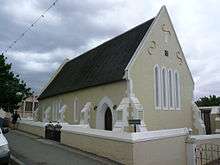 |
| 9/2/092/0058 | Osloo House, 120 Voortrek Street, Swellendam | Swellendam | Swellendam | Provincial Heritage Site | 34°01′19″S 20°26′31″E / 34.022053°S 20.441831°E |
| |
| 9/2/092/0059 | Die Kloof, Weltevreden Street, Swellendam | Swellendam | Swellendam | Provincial Heritage Site | 34°00′57″S 20°26′33″E / 34.015967°S 20.442469°E |
| |
| 9/2/092/0060 | Buffeljachtsrivier Bridge, Swellendam District | Type of site: Bridge Current use: Bridge. | Swellendam | Provincial Heritage Site | 34°02′44″S 20°32′06″E / 34.045683°S 20.534987°E |
| |
| 9/2/092/0061 | SUURBRAAK, SWELLENDAM DISTRICT, GENERAL | Suurbraak | Swellendam | National Monument |
| ||
| 9/2/092/0062 | SWELLENDAM MAGISTERIAL DISTRICT, GENERAL | Swellendam | Swellendam |
| |||
| 9/2/092/0063 | BONNIEVALE LOCAL AREA, GENERAL | Bonnievale | Swellendam |
| |||
| 9/2/092/0064 | MALGAS LOCAL AREA, GENERAL | Malgas | Swellendam |
| |||
| 9/2/092/0065 | BARRYDALE LOCAL AREA, GENERAL | Barrydale | Swellendam |
| |||
| 9/2/092/0066 | Conservation Area, Suurbraak, Swellendam District | Suurbraak | Swellendam |
| |||
| 9/2/092/0067 | Grier Bridge, Breede River, Swellendam District | Type of site: Bridge. For 150 years vehicular traffic crossed the Breede River at a pont. Near the site of the second pont the first bridge over the Breede river near Swellendam was built in the early 1890s. It is a triumph of Victorian engineering. Sections of the iron bri | Swellendam | Provincial Heritage Site | 34°01′31″S 20°26′14″E / 34.025379°S 20.437231°E |
|
References
- ↑ "Western Cape Provincial Heritage Sites (previously National Monuments)" (PDF). 19 September 2002. Retrieved 2013-01-28.
| Wikimedia Commons has media related to Cultural heritage monuments in Swellendam. |
Lists of South African Heritage Resources | ||||||||||||||||||||||||||||||||||||
|---|---|---|---|---|---|---|---|---|---|---|---|---|---|---|---|---|---|---|---|---|---|---|---|---|---|---|---|---|---|---|---|---|---|---|---|---|
| SAHRA Heritage sites |
| |||||||||||||||||||||||||||||||||||
| World heritage sites | ||||||||||||||||||||||||||||||||||||