List of heritage sites in George and Mossel Bay
This is a list of the heritage sites in George and Mossel Bay, situated in the Western Cape, as recognized by the South African Heritage Resources Agency.[1]
| SAHRA identifier | Site name | Description | Town | District | NHRA status | Coordinates | Image |
|---|---|---|---|---|---|---|---|
| 9/2/022/0039 | GRAAFWATER LOCAL AREA GENERAL | Graafwater | George | 
| |||
| 9/2/030/0001 | Farmhouse, Eensaamheid, Langkloof, Noll, George District | George | George |
| |||
| 9/2/030/0002 | GEORGE MUNICIPAL AREA, GENERAL | George | George |
| |||
| 9/2/030/0003 | The Tree of Meetings, Mission Street, Pacaltsdorp, George District | Pacaltsdorp | George |
| |||
| 9/2/030/0004 | Old Cemetery, Kloof Street, Pacaltsdorp, George District | Pacaltsdorp | George |
| |||
| 9/2/030/0005 | The Board House, Church Street, Pacaltsdorp, District | Pacaltsdorp | George |
| |||
| 9/2/030/0006 | Mission School, Church Street, Pacaltsdorp, George District | Pacaltsdorp | George |
| |||
| 9/2/030/0007 | Church and church buildings, Pacaltsdorp | The church building in Pacaltsdorp was consecrated in 1825 and is one of the most impressive of the remaining examples of the early Gothic revival in South Africa.
Near the church stands the original parsonage which was erected in 1835, the present parson
|
Pacaltsdorp | George | Provincial Heritage Site | 34°00′56″S 22°27′21″E / 34.015532°S 22.455813°EPacaltsdorp) | 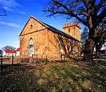 |
| 9/2/030/0007/02 | Rev Pacalt’s Cottage, Mission Street, Pacaltsdorp, George District | Pacaltsdorp | George |
| |||
| 9/2/030/0007/03 | Old London Mission Society Church, Mission Street, Pacaltsdorp, George District | Pacaltsdorp | George |
| |||
| 9/2/030/0007/1 | Old Parsonage, Mission Street, Pacaltsdorp, George District | Pacaltsdorp | George |
| |||
| 9/2/030/0008 | Old Baptist Church, Meade Street, George | George | George |
| |||
| 9/2/030/0009 | Montagu Pass, George District | The Montagu Pass near George, which replaced the older Cradock Pass, was built after 1843 by the engineer Henry Francourt White at a cost of R71 598.
The pass was named after the Colonial Secretary, John Montagu, who officially opened the pass in December
|
George | Provincial Heritage Site | 33°54′34″S 22°25′06″E / 33.909380°S 22.418289°EMontagu Pass, George District) | 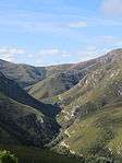 | |
| 9/2/030/0009/002 | Old Tollhouse, Montagu Pass, George District | This toll-house dates back to the middle of the 19th Century and from here, at the bottom of the Montagu Pass, toll was collected after the pass had been opened for traffic in 1849.
|
George | Provincial Heritage Site | 33°55′07″S 22°24′59″E / 33.918747°S 22.416425°E | 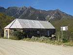 | |
| 9/2/030/0009/003 | Keur River Bridge, Montagu Pass, George District | This attractive arched stone bridge was part of the original construction of the Montagu Pass which was opened by Sir John Montagu in 1847,
|
George | Provincial Heritage Site | 33°54′25″S 22°25′06″E / 33.906856°S 22.418447°E | 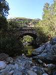 | |
| 9/2/030/0009/01 | Old Hotel, Montagu Pass, George District | George | George | Pending Provincial Declaration |
| ||
| 9/2/030/0009/04 | Montagu Pass Road, Montagu Pass, George Dist | George | George | 33°53′41″S 22°25′13″E / 33.894801°S 22.420357°E |
| ||
| 9/2/030/0010 | Bamboo Lodge, York Street, George | Type of site: House
|
George | George | Provisional Protection | 33°57′49″S 22°27′10″E / 33.963707°S 22.452894°E |
|
| 9/2/030/0011 | Eikenhof, Courtenay Street, George | George | George |
| |||
| 9/2/030/0012 | Old Gaol, De Bult Boys High School, George | Type of site: Gaol, School
|
George | George | Provincial Heritage Site | 33°57′18″S 22°27′01″E / 33.955119°S 22.450262°E | 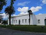 |
| 9/2/030/0013 | Silviculturist Dwelling, Beervlei Forest Reserve, George District | George | George |
| |||
| 9/2/030/0014 | Silviculturist Dwelling, Groenkop Forest Reserve, Saasveld, George | George | George |
| |||
| 9/2/030/0015 | Meade House, 91 Meade Street, George | George | George | 33°57′45″S 22°27′28″E / 33.962523°S 22.457712°E |
| ||
| 9/2/030/0016 | Dutch Reformed Church Complex, Courtenay Street, George | Type of site: Church
|
George | George | Provincial Heritage Site | 33°57′22″S 22°27′47″E / 33.956204°S 22.463098°E | 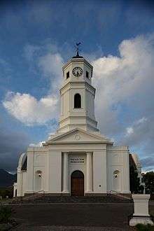 |
| 9/2/030/0016-001 | Dutch Reformed Church, Courtenay Street, George | Type of site: Church
|
George | George | Provincial Heritage Site | 33°57′25″S 22°27′45″E / 33.956860°S 22.462487°E | 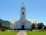 |
| 9/2/030/0016-002 | Dutch Reformed Church Parsonage, Courtenay Street, George | Type of site: Church
|
George | George | Provincial Heritage Site | 33°57′24″S 22°27′44″E / 33.956538°S 22.462119°E | 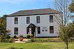 |
| 9/2/030/0017 | VOC Beacon, George Museum, George | The beacon together with others was caused to be erected by Governor Van der Graaff in 1785 to show the Company’s authority and to strengthen its claim to the territory.
The public library of George stands in the shadow of a giant, historical oak.
|
George | George | Heritage Object | 33°58′10″S 22°25′49″E / 33.969377°S 22.430258°EGeorge Museum, George) | |
| 9/2/030/0018 | Fancourt Hotel, George | Type of site: Hotel | George | George | Provincial Heritage Site | 33°57′01″S 22°24′25″E / 33.950416°S 22.407035°E |
|
| 9/2/030/0019 | St Peter & St Paul's Roman Catholic Church, Mead Street, George | George | George |
| |||
| 9/2/030/0020 | Seven-day Adventist Church, 47 Market Street, George | George | George | 33°57′47″S 22°27′37″E / 33.963131°S 22.460228°E |
| ||
| 9/2/030/0022 | Oakhurst, Hoekwil, George District | George | George | 33°57′31″S 22°27′40″E / 33.958525°S 22.461113°E |
| ||
| 9/2/030/0023 | Cradock Pass, George District | Type of site: Pass | George | Provincial Heritage Site | 33°58′17″S 22°27′12″E / 33.971425°S 22.453437°E |
| |
| 9/2/030/0023/01 | Outeniqua Cableway, Cradock Pass, George District | George | George |
| |||
| 9/2/030/0024 | Oorskotjie, York Street, George | George | George |
| |||
| 9/2/030/0025 | Outeniqua Pass, George District | George | George |
| |||
| 9/2/030/0026 | 127 York Street, George | George | George | 33°57′21″S 22°27′29″E / 33.955819°S 22.458073°E |
| ||
| 9/2/030/0028 | Oak tree, Main Street, George | On the Groote Wagen Weg from Swellendam via Mossel Bay to the east lies 'the prettiest little town in the world' according to Anthony Trollope.
The first traveller to be enraptured by this beautiful valley in the foothills of the Outeniqua Mountains was
|
George | George | Provincial Heritage Site | 33°59′23″S 22°28′47″E / 33.989720°S 22.479705°E | 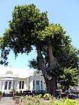 |
| 9/2/030/0029 | PACALTSDORP LOCAL AREA, GENERAL | Pacaltsdorp | George |
| |||
| 9/2/030/0030 | The Attic, 33 Langenhoven Street, George | This impressive double-storeyed building with its Georgian features was erected in about 1840.
In 1982 it was restored and converted into offices. |
George | George | Provincial Heritage Site | 33°57′24″S 22°27′08″E / 33.956635°S 22.452190°E |  |
| 9/2/030/0031 | St Pauls Church School, Market Lane, George | This building was erected in 1855 and for many years served as the school and church for the Coloured community of St Mark's.
|
George | George | Provincial Heritage Site | 33°57′49″S 22°27′41″E / 33.963672°S 22.461526°E | 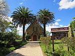 |
| 9/2/030/0033 | Meulrivier, George District | Type of site: Farmstead | George | Provincial Heritage Site | 33°59′23″S 22°29′32″E / 33.989687°S 22.492136°E |
| |
| 9/2/030/0034 | Old George-Knysna Road, George District | The road between George and Knysna was constructed with great skill between 1862 and 1882 by Thomas Bain.
It has seven passes crossing rivers in densely forested gorges.
The declared part is unspoilt and includes two concrete bridges.This picturesque grav
|
George | Provincial Heritage Site | 22°29′32″N 22°29′25″E / 22.492136°N 22.490236°E | 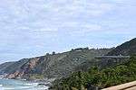 | |
| 9/2/030/0034-001 | Kaaimans River Bridge, Old George-Knysna Road, George District | Type of site: Bridge | George | Provincial Heritage Site | 33°58′16″S 22°32′52″E / 33.970985°S 22.547668°E | 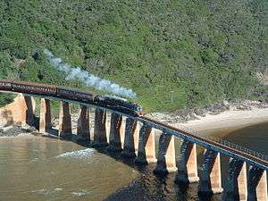 | |
| 9/2/030/0034-002 | Silver River Bridge, Old George-Knysna Road, George District | Type of site: Bridge | George | Provincial Heritage Site | 33°57′54″S 22°33′42″E / 33.964865°S 22.561616°E |
| |
| 9/2/030/0034-003 | Touw River Bridge, Old George-Knysna Road, George District | Type of site: Bridge | George | Provincial Heritage Site | 33°56′48″S 22°36′44″E / 33.946613°S 22.612334°E |
| |
| 9/2/030/0035 | Ralsons, 48 Hibernia Street, George | George | George | 33°57′40″S 22°27′42″E / 33.961189°S 22.461751°E |
| ||
| 9/2/030/0036 | Barn complex, Wilderness, George District | Wilderness | George |
| |||
| 9/2/030/0037 | GEORGE MAGISTERIAL DISTRICT, GENERAL | George | George |
| |||
| 9/2/030/0038 | Fairview, 36 Stander Street, George | George, Bergsig | George | Register | 33°57′25″S 22°28′37″E / 33.956845°S 22.476886°E | 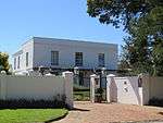 | |
| 9/2/030/0039 | WILDERNESS LOCAL AREA | Wilderness | George |
| |||
| 9/2/030/0040 | St. Marks Anglican Cathedral, York Street, George | George | George | 33°57′27″S 22°27′30″E / 33.957620°S 22.458339°E |
| ||
| 9/2/030/0040/01 | St. Marks Anglican Cathedral Cemetery | George | George | 33°57′27″S 22°27′30″E / 33.957620°S 22.458339°E |
| ||
| 9/2/030/0041 | Riversyde, 2 Lang Street, George | George | George | 33°58′50″S 22°26′39″E / 33.980605°S 22.444244°E |
| ||
| 9/2/064/0001 | MOSSEL BAY MUNICIPAL AREA, GENERAL | Mossel Bay | Mossel Bay |
| |||
| 9/2/064/0002 | 20-22 Upper Cross Street, Mossel Bay | Mossel Bay | Mossel Bay | 34°11′02″S 22°09′08″E / 34.183911°S 22.152116°E |
| ||
| 9/2/064/0003 | Bartolomeu Dias Museum Complex, Mossel Bay | Current use: Museum. | Mossel Bay | Mossel Bay | Provincial Heritage Site | 34°10′48″S 22°08′36″E / 34.180133°S 22.143400°EBartolomeu Dias Museum Complex, Mossel Bay) | 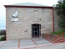 |
| 9/2/064/0003/001 | Post office tree area, Bartholomeu Dias Museum Complex, Mossel Bay | White Milkwood (Sideroxylon Inerme)
5 m tall A romantic tale centres round this tree in Munro Bay Road, about one kilometre from the Mossel Bay railway station and 350 metres from Santos Beach.
Nearly two and a half centuries before the white colonists found their way with difficulty over the mountain
|
Mossel Bay | Mossel Bay | Provincial Heritage Site | 34°10′48″S 22°08′37″E / 34.180126°S 22.143534°E | 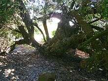 |
| 9/2/064/0003/002 | Munro's Corner, Bartholomeu Dias Museum Complex, Mossel Bay | Current use: Museum. | Mossel Bay | Mossel Bay | Provincial Heritage Site | 34°10′48″S 22°08′33″E / 34.179901°S 22.142599°E | 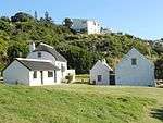 |
| 9/2/064/0004 | 66 Montagu Street, Mossel Bay | Mossel Bay | Mossel Bay | National Monument | 34°11′03″S 22°08′50″E / 34.184215°S 22.147117°E |
| |
| 9/2/064/0005 | 46 Upper Cross Street, Mossel Bay | Mossel Bay | Mossel Bay | 34°11′01″S 22°08′56″E / 34.183669°S 22.148893°E |
| ||
| 9/2/064/0006 | Attaquaskloof Pass, Mossel Bay District | Type of site: Pass Attaqua's Kloof is named after the tribe of Khoi living in the vicinity when the pass was traversed in 1689 by Ensign Isaac Schrijver and his party from the Cape.
It is the oldest pass in the Langeberg and Outeniqua Mountain ranges of the Southern Cape, |
Mossel Bay | Provincial Heritage Site | 34°11′00″S 22°07′56″E / 34.183350°S 22.132344°E |
| |
| 9/2/064/0007 | St Thomas Church, 28 Marsh Street, Mossel Bay | Mossel Bay | Mossel Bay | Pending Declaration | 34°11′00″S 22°09′01″E / 34.183256°S 22.150304°E |
| |
| 9/2/064/0008 | Cape St Blaize Lighthouse, Mossel Bay District | Mossel Bay | Mossel Bay | 34°11′10″S 22°09′23″E / 34.186224°S 22.156320°E |
| ||
| 9/2/064/0009 | 24 Montagu Street, Mossel Bay | Mossel Bay | Mossel Bay | 34°11′04″S 22°09′05″E / 34.184423°S 22.151428°E |
| ||
| 9/2/064/0010 | St Peters Church, Marsh Street, Mossel Bay | Exterior:
English style stone church
Stone: fibre cement tiles (originally Welsh slate)
Steep pitched hammer beam roof
Tower has an unusual stone steeple
Parapets, gables and buttresses have dressed stone copings
Teak doors
The nave has diamond pane
|
Mossel Bay | Mossel Bay | Provincial Heritage Site | 34°10′56″S 22°08′21″E / 34.182346°S 22.139061°E | 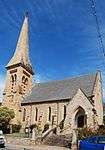 |
| 9/2/064/0011 | 84 Hill Street, Mossel Bay | Mossel Bay | Mossel Bay | Pending Declaration | 34°11′06″S 22°08′43″E / 34.185134°S 22.145298°E |
| |
| 9/2/064/0012 | Ochre Building, Church Street, Mossel Bay | Mossel Bay | Mossel Bay |
| |||
| 9/2/064/0013 | 14 Queen Street, Mossel Bay | Mossel Bay | Mossel Bay | 34°11′01″S 22°08′49″E / 34.183582°S 22.146908°E |
| ||
| 9/2/064/0014 | Old Municipal Cemetery, Mossel Bay | Mossel Bay | Mossel Bay | 34°11′13″S 22°07′12″E / 34.187036°S 22.119894°E |
| ||
| 9/2/064/0015 | GREAT BRAK RIVER MUNICIPAL AREA, MOSSEL BAY DISTRICT, GENERAL | Mossel Bay | Mossel Bay |
| |||
| 9/2/064/0015-001 | Riversyde House, 2 Long Street, Great Brak River | Great Brak River | Mossel Bay | Register | 34°02′27″S 22°13′16″E / 34.040912°S 22.221106°E |
| |
| 9/2/064/0016 | Langkraal, Mossel Bay District | The land on which the Langkraal homestead is situated originally formed part of the farm Outeniquasbosch which was granted to Jean Charles de la Harpe in 1815.
The Cape Dutch farmhouse erected by him is believed to have been enlarged during the 1840’s, Th |
Mossel Bay | Provincial Heritage Site | 34°11′01″S 22°08′08″E / 34.183563°S 22.135434°E |
| |
| 9/2/064/0017 | Prince Vincent & Co building, 86 Bland Street, Mossel Bay | Mossel Bay | Mossel Bay | National Monument | 34°10′54″S 22°08′36″E / 34.181620°S 22.143369°E |
| |
| 9/2/064/0018 | LITTLE BRAK RIVER MUNICIPAL AREA, MOSSEL BAY DISTRICT, GENERAL | Mossel Bay | Mossel Bay |
| |||
| 9/2/064/0019 | 31 Marsh Street, Mossel Bay | Mossel Bay | Mossel Bay | 34°10′57″S 22°09′01″E / 34.182588°S 22.150222°E |
| ||
| 9/2/064/0020 | 52 & 54 Bland Street, Mossel Bay | Mossel Bay | Mossel Bay | 34°10′54″S 22°09′00″E / 34.181746°S 22.149894°E |
| ||
| 9/2/064/0021 | Dutch Reformed Church, Friemersheim, Great Brak River | Mossel Bay | Mossel Bay | 34°03′00″S 22°12′53″E / 34.050073°S 22.214729°E |
| ||
| 9/2/064/0022 | HERBERTSDALE MUNICIPAL AREA, MOSSEL BAY DISTRICT, GENERAL | Mossel Bay | Mossel Bay |
| |||
| 9/2/064/0023 | Park House, 118 Montagu Street, Mossel Bay | Mossel Bay | Mossel Bay | 34°11′01″S 22°08′29″E / 34.183739°S 22.141354°E |
| ||
| 9/2/064/0024 | 38 Marsh Street, Mossel Bay | Mossel Bay | Mossel Bay | 34°11′02″S 22°09′16″E / 34.183995°S 22.154436°E |
| ||
| 9/2/064/0025 | HARTENBOS MUNICIPAL AREA, MOSSEL BAY DISTRICT, GENERAL | Mossel Bay | Mossel Bay |
| |||
| 9/2/064/0027 | Old Market Hall, Market Square, Mossel Bay | This impressive building was erected in approximately 1852 and forms an essential part of the historic centre of Mossel Bay
|
Mossel Bay | Mossel Bay | Provincial Heritage Site | 34°10′49″S 22°08′35″E / 34.180172°S 22.143017°E |
|
| 9/2/064/0028 | Carpenter's shop, 87 Montagu Street, Mossel Bay | Single storey, rectangular, 3 bays
Stone: corrugated iron Pitched roof with parapet gable end on Marsh Street façade Arched doorway with 4 panelled double doors and arched fanlight Front elevation has 2x2 sash windows West elevation has 2x3 sash windows The building is thought to be by Sir Herbert Baker and built by W.J.Swart in 1898. The stone was apparently quarried from Cape St Blaize and crafted by Mr. Swart himself. After his death, the building was used as a house, a doveclub and later for storage. Important example of building type and design Contributes to character of the street and area |
Mossel Bay | Mossel Bay | Provincial Heritage Site | 34°11′02″S 22°08′40″E / 34.183843°S 22.144573°E |
|
| 9/2/064/0029 | The Point, Mossel Bay | Three irregular rows following the curve of the shoreline
Middle and back rows separated by a curved road
Pathways, some with steps, situated between the bungalows. Most bungalows started as rectangular buildings with front verandahs and rear lean-tos
The bungalows represent a style of seaside holidaying that was popular in South Africa, but
of which very little remains.
They were built in the aftermath of WW II.
It was especially people from inland who had the need to escape the heat who came to camp
|
Mossel Bay | Mossel Bay | Provisional Protection | 34°11′05″S 22°09′23″E / 34.184830°S 22.156495°E |
|
| 9/2/064/0030 | MOSSEL BAY MAGISTERIAL DISTRICT, GENERAL | Mossel Bay | Mossel Bay |
| |||
| 9/2/064/0031 | Gourits River Bridge, Mossel Bay District | Mossel Bay | Mossel Bay | 34°11′10″S 21°45′11″E / 34.186043°S 21.753164°E |
| ||
| 9/2/064/0032 | 15 Meyer Street, Mossel Bay | Mossel Bay | Mossel Bay | 34°11′00″S 22°08′47″E / 34.183360°S 22.146364°E |
| ||
| 9/2/064/0033 | Methodist Church Complex, Queen Street, Mossel Bay | Mossel Bay | Mossel Bay | 34°11′00″S 22°08′50″E / 34.183294°S 22.147092°E |
| ||
| 9/2/064/0034 | Military Grave, Farm Brandwacht, Mossel Bay District | Mossel Bay | Mossel Bay |
| |||
| 9/2/064/0035 | Burial Site, Voelvlei, Mossel Bay District | Mossel Bay | Mossel Bay |
| |||
| 9/2/064/0036 | Burial Site, Nestle Factory, Voorbaai Mossel Bay Dist | Mossel Bay | Mossel Bay |
| |||
| 9/2/064/0038 | TARKA LOCAL AREA, GENERAL | Mossel Bay | Mossel Bay |
| |||
| 9/2/064/0039 | Friemersheim (near Great Brak Municipal Area), Mossel Bay District | Mossel Bay | Mossel Bay | 33°57′36″S 22°08′15″E / 33.959865°S 22.137428°E |
|
References
- ↑ "Western Cape Provincial Heritage Sites (previously National Monuments)" (PDF). 19 September 2002. Retrieved 2013-01-28.
| Wikimedia Commons has media related to Cultural heritage monuments in George, Western Cape. |
Lists of South African Heritage Resources | ||||||||||||||||||||||||||||||||||||
|---|---|---|---|---|---|---|---|---|---|---|---|---|---|---|---|---|---|---|---|---|---|---|---|---|---|---|---|---|---|---|---|---|---|---|---|---|
| SAHRA Heritage sites |
| |||||||||||||||||||||||||||||||||||
| World heritage sites | ||||||||||||||||||||||||||||||||||||