List of heritage sites in Robertson and Montagu
This is a list of the heritage sites in Robertson and Montagu, situated in the Western Cape, as recognized by the South African Heritage Resources Agency.[1]
| SAHRA identifier | Site name | Description | Town | District | NHRA status | Coordinates | Image |
|---|---|---|---|---|---|---|---|
| 9/2/063/0001 | 50 Long Street, Montagu | This gabled house dates from 1858 and forms an important element in the street scene of Long Street, Montagu.
This dwelling-house has straight end gables and a plain front gable and is a typical example of this specific phase of the Cape-Dutch architecture |
Montagu | Montagu | Provincial Heritage Site | 33°47′21″S 20°07′13″E / 33.789236°S 20.120229°E | 
|
| 9/2/063/0002 | 33 Long Street, Montagu | These five properties form an integral part of the historical core of Montagu, which was largely laid out on the farm Uitvlugt in 1850.
The buildings which are situated in Long Street, the oldest street in the town, as well as Bath Street, which serves as |
Montagu | Montagu | Provincial Heritage Site | 33°47′20″S 20°07′23″E / 33.788790°S 20.123158°E | 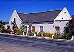 |
| 9/2/063/0003 | 46 Long Street, Montagu | This thatch-roofed house with its two plain straight end- gables, which was built predominantly in the Cape Dutch style, dates from the 1850s. | Montagu | Montagu | Provincial Heritage Site | 33°47′22″S 20°07′10″E / 33.789352°S 20.119486°E |
|
| 9/2/063/0004 | 55 Long Street, Montagu | Montagu | Montagu | National Monument | 33°47′17″S 20°07′30″E / 33.788049°S 20.124980°E |
| |
| 9/2/063/0005 | MONTAGU MUNICIPAL AREA, GENERAL | Montagu | Montagu | Pending Declaration |
| ||
| 9/2/063/0006 | 6 Long Street, Montagu | These five properties form an integral part of the historical core of Montagu, which was largely laid out on the farm Uitvlugt in 1850.
The buildings which are situated in Long Street, the oldest street in the town, as well as Bath Street, which serves as |
Montagu | Montagu | Provincial Heritage Site | 33°47′25″S 20°06′54″E / 33.790252°S 20.114865°E |
|
| 9/2/063/0007 | British fort, Cogmanskloof, Montagu | Montagu | Montagu | National Monument |  | ||
| 9/2/063/0008 | 40 Long Street, Montagu | Montagu | Montagu | Provincial Heritage Site | 33°47′21″S 20°07′13″E / 33.789281°S 20.120258°E |
| |
| 9/2/063/0009 | 17 Long Street, Montagu | This Cape Dutch house, the front gable of which is an excellent example of the so-called Worcester gable, was erected in 1859.
The house reflects the architectural tradition which gives Long Street and the historical core of Montagu their character. |
Montagu | Montagu | Provincial Heritage Site | 33°47′23″S 20°07′03″E / 33.789807°S 20.117418°E | 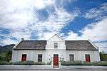 |
| 9/2/063/0010 | 42A and 44 Bath Street, Montagu | Montagu | Montagu | Provincial Heritage Site | 33°47′12″S 20°07′18″E / 33.786706°S 20.121610°E |
| |
| 9/2/063/0011 | Dutch Reformed Church Parsonage, 9 Rose Street, Montagu | The parsonage in Rose Street, Montagu, was built in Dr D.
F.
Malan who resided there until 1913.
T
|
Montagu | Montagu | Provincial Heritage Site | 33°47′47″S 20°07′19″E / 33.796454°S 20.122082°E |
|
| 9/2/063/0012 | Municipal office, 3 Piet Retief Street, Montagu | These five properties form an integral part of the historical core of Montagu, which was largely laid out on the farm Uitvlugt in 1850.
The buildings which are situated in Long Street, the oldest street in the town, as well as Bath Street, which serves as
|
Montagu | Montagu | Provincial Heritage Site | 33°47′11″S 20°07′05″E / 33.786302°S 20.117934°E |
|
| 9/2/063/0013 | Erf 0161, 20 Bath Street, Montagu | These five properties form an integral part of the historical core of Montagu, which was largely laid out on the farm Uitvlugt in 1850.
The buildings which are situated in Long Street, the oldest street in the town, as well as Bath Street, which serves as
|
Montagu | Montagu | Provincial Heritage Site | 33°47′16″S 20°07′04″E / 33.787753°S 20.117659°E |
|
| 9/2/063/0014 | 24 Bath Street, Montagu | These five properties form an integral part of the historical core of Montagu, which was largely laid out on the farm Uitvlugt in 1850.
The buildings which are situated in Long Street, the oldest street in the town, as well as Bath Street, which serves as These five properties form an integral part of the historical core of Montagu. The buildings are the oldest street in the town and date from the late nineteenth century reflecting the Cape Dutch and Victorian styles of building. |
Montagu | Montagu | Provincial Heritage Site | 33°47′16″S 20°07′06″E / 33.787662°S 20.118206°E |
|
| 9/2/063/0015 | 58 Long Street, Montagu | This unique complex, consisting of a rural Cape Dutch house and semi-detached wine cellar, was erected in 1871 by Francois du Toit.
He was married to the daughter of Gideon Johannes Retief, youngest brother of the Voortrekker leader Net Retief. This compl This unique complex, consisting of a rural Cape Dutch house and semi-detached wine cellar, was erected in 1871 by Francois du Toit. He was married to the daughter of Gideon Johannes Retief, youngest brother of the Voortrekker leader Net Retief. This compl |
Montagu | Montagu | Provincial Heritage Site | 33°46′08″S 20°07′32″E / 33.768913°S 20.125440°E |
|
| 9/2/063/0016 | 21 Piet Retief Street, Montagu | The property on which this true Victorian dwelling-house is situated was originally transferred to P.
A. Euvrard on 9 November 1859. The house was presumably built by him. |
Montagu | Montagu | Provincial Heritage Site | 33°47′09″S 20°07′16″E / 33.785917°S 20.121196°E |
|
| 9/2/063/0017 | 26 Long Street, Montagu | This double-storeyed building with its typical Georgian features dates from the 1890s.
The property not only forms an integral part of the historic core of Montagu, but is also a significant architectural component of Long Street, the oldest street in the |
Montagu | Montagu | Provincial Heritage Site | 33°46′07″S 20°07′31″E / 33.768592°S 20.125247°E |
|
| 9/2/063/0018 | Dutch Reformed Church, Bath Street, Montagu | Type of site: Church
|
Montagu | Montagu | Provincial Heritage Site | 33°47′16″S 20°06′58″E / 33.787763°S 20.116189°E | 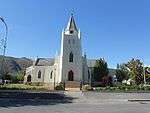 |
| 9/2/063/0019 | Montagu Museum, Long Street, Montagu | The old Mission Church at Montagu was built in 1907 and is of considerable interest, both from the architectural point of view and with regard to the unique street facade of Long Street.
|
Montagu | Montagu | Provincial Heritage Site | 33°47′25″S 20°07′00″E / 33.790220°S 20.116611°E | 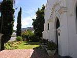 |
| 9/2/063/0020 | 32 Long Street, Montagu | This dwelling is largely in the Cape Dutch style, with, the cellar forming an integral part of the house.
This property and the other historic buildings in Long Street form an important historical and architectural group. |
Montagu | Montagu | Provincial Heritage Site | 33°46′08″S 20°07′33″E / 33.768818°S 20.125794°E |
|
| 9/2/063/0021 | 35 Long Street, Montagu | Montagu | Montagu | Provincial Heritage Site | 33°46′09″S 20°07′33″E / 33.769175°S 20.125880°E |
| |
| 9/2/063/0022 | Joubert House, 25 Long Street, Montagu | This T-shaped Cape Dutch house was erected in 1854 and is one of the three oldest houses in Montagu.
In June 1880 S.
J.
P.
Kruger and General P.
J.
Joubert were entertained in this house.
|
Montagu | Montagu | Provincial Heritage Site | 33°47′23″S 20°07′06″E / 33.789654°S 20.118333°E |
|
| 9/2/063/0023 | Old Library, Bath Street, Montagu | These five properties form an integral part of the historical core of Montagu, which was largely laid out on the farm Uitvlugt in 1850.
The buildings which are situated in Long Street, the oldest street in the town, as well as Bath Street, which serves as
|
Montagu | Montagu | Provincial Heritage Site | 33°47′16″S 20°07′06″E / 33.787662°S 20.118206°E |
|
| 9/2/063/0024 | 30 Bath Street, Montagu | Montagu | Montagu | Provincial Heritage Site | 33°47′15″S 20°07′08″E / 33.787424°S 20.118921°E |
| |
| 9/2/063/0025 | 20 Long Street, Montagu | Montagu | Montagu | Provincial Heritage Site | 33°46′06″S 20°07′31″E / 33.768390°S 20.125365°E |
| |
| 9/2/063/0027 | Mimosa Lodge, 15 Church Street, Montagu | Type of site: House
|
Montagu | Montagu | Register | 33°47′00″S 20°07′00″E / 33.783333°S 20.116667°E |
|
| 9/2/063/0028 | MONTAGU MAGISTERIAL DISTRICT, GENERAL | Montagu | Montagu | Pending Declaration |
| ||
| 9/2/063/0029 | Montagu Cave, Farm Derdeheuwel, Montagu District | Montagu | Montagu |
| |||
| 9/2/063/0030 | Eerstepos, 18 Church Street, Montagu | This Victorian building was the first post office in Montagu, also used during the Anglo-Boer War as the headquarters of the British troops, and became a residential home from about 1918.
It is very well kept and largely in tact. The house froms part o |
Montagu | Montagu | Register | 33°47′00″S 20°07′00″E / 33.783333°S 20.116667°E |
|
| 9/2/063/0031 | ASHTON MUNICIPAL AREA, GENERAL | Ashton | Montagu |
| |||
| 9/2/080/0001 | ROBERTSON MUNICIPAL AREA, GENERAL | Robertson | Robertson |
| |||
| 9/2/080/0002 | McGREGOR MUNICIPAL AREA, ROBERTSON DISTRICT, GENERAL | McGregor | Robertson | 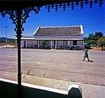 | |||
| 9/2/080/0002-293 | Erf 377, Voortrekker Street, McGregor | T-plan vernacular cottage with reed thatch, hooded gable over front door and straight end gables.
External hearth.
4-pane casements, wooden door.
|
McGregor | Robertson | Provincial Heritage Site | 33°56′56″S 19°49′38″E / 33.948790°S 19.827144°E |
|
| 9/2/080/0002-307 | Erven 189, 190, 191 cnr Barry and Mill Streets, McGregor | Vernacular cottage thatched roof and straight end gables.
Additions with lower thatched roof and stepped-up parapet to left.
8 x 8 casements.
6 x 6 sashes and 12-pane casements.
Extension to right has flat roof with stepped parapets, pergola on plastered The oldest of these two buildings is a T-shaped cottage in the vernacular style and dates from about 1860.
The second cottage is from a later phase and is constructed in the typical Georgian Karoo style.
The property in its entirety forms an important ar
|
McGregor | Robertson | Provincial Heritage Site | 33°56′38″S 19°49′49″E / 33.943811°S 19.830173°E |
|
| 9/2/080/0002-314 | Mulberry Cottage, 430, Barry Street, McGregor | Vernacular cottage with reed thatch and straight end gables.
Slatted shutters to windows.
Outbuilding with parapet walls.
|
McGregor | Robertson | Provincial Heritage Site | 33°56′41″S 19°49′53″E / 33.944790°S 19.831460°E |
|
| 9/2/080/0002-317 | Erf 378, Peppertree Cottage, Voortrekker Street, McGregor | Vernacular cottage with reed thatch, straight end gables and external hearth.
6-pane casements with exposed wood lintels.
Stable door.
This property forms part of the historic centre of McGregor with its picturesque houses in the vernacular style. 10/2/542. P. G. J. KOORNHOF, Minister of National Education. |
McGregor | Robertson | Provincial Heritage Site | 33°56′55″S 19°49′39″E / 33.948526°S 19.827411°E | |
| 9/2/080/0002-321 | Erf 378, McGregor | McGregor | Robertson | Provincial Heritage Site | 33°56′34″S 19°49′29″E / 33.942845°S 19.824652°E |
| |
| 9/2/080/0003 | Dwelling, Erf 275, Keerom Street, McGregor, Robertson District | McGregor | Robertson |
| |||
| 9/2/080/0004 | Orange Grove, Norree, Robertson District | McGregor | Robertson | 33°44′38″S 19°47′16″E / 33.743756°S 19.787900°E |
| ||
| 9/2/080/0005 | Old Wesleyan Church, Paul Kruger Street, Robertson | Type of site: Church | Robertson | Robertson | Provisional Protection | 33°48′01″S 19°53′09″E / 33.800334°S 19.885839°E |
|
| 9/2/080/0006 | Oupa se Wingerd, Weltevrede Wine Estate, Robertson District | Type of site: Vineyard Landscape Oupa se Wingerd is a small block of 780 vines which are the remnant of a vineyard of 16 000 red muscadel vines planted in 1926 by Klaas Jonker, founder of the Weltevrede Estate and one of the early wine farmers of the region.
These remaining vines are |
Robertson | Register | 33°56′12″S 20°02′27″E / 33.936742°S 20.040725°E |
| |
| 9/2/080/0007 | Old Mill Lodge, Mill Street, McGregor | McGregor | Robertson | 33°55′51″S 19°49′22″E / 33.930969°S 19.822754°E |  | ||
| 9/2/080/0007-003 | Old Mill Lodge, Erf 4, 100, Mill Street, McGregor | Vacant erf Historical and architectural interest
These cottages, in the vernacular style, date from the second half of the nineteenth century. The water mill is one of the few remaining undamaged mills in our country. The properties form an important architectural p |
McGregor | Robertson | Provincial Heritage Site | 33°56′51″S 19°49′34″E / 33.947526°S 19.826070°E |
|
| 9/2/080/0007/1 | Erf 644, Voortrekker Street, McGregor | McGregor | Robertson | National Monument |
| ||
| 9/2/080/0008 | Erf 4, Mill Street, McGregor | McGregor | Robertson | Provincial Heritage Site | 33°56′51″S 19°49′34″E / 33.947526°S 19.826070°E |
| |
| 9/2/080/0009 | Die Trein, Erf 51, Voortrekker Street, McGregor | 4 attached vernacular cottages, straight end gables with parapets except for cottage 2nd from left which has flat roof behind stepped up parapet with simple moulded detail.
Windows are 3 x 2 sliding sashes, doors have 3-pane fanlights over.
Cement stoep
|
McGregor | Robertson | Provincial Heritage Site | 33°56′59″S 19°49′35″E / 33.949659°S 19.826294°E | 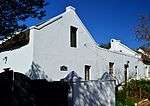 |
| 9/2/080/0010 | "Ons Huisie", Long Street, McGregor, Robertson District | McGregor | Robertson | National Monument | 33°56′37″S 19°49′50″E / 33.943665°S 19.830547°E |
| |
| 9/2/080/0011 | Sewenfontein, Robertson District | McGregor | Robertson |
| |||
| 9/2/080/0012 | Powder Magazine, Robertson | The Power Magazine in Robertson was erected by Barry and Nephews in 1880 and was used for the storage of explosives until 1965.
|
Robertson | Robertson | Provincial Heritage Site |
| |
| 9/2/080/0013 | Druid's Lodge, Paul Kruger Street, Robertson | This predominantly Georgian dwelling-house was probably one of the earliest houses erected at Robertson after its foundation in 1853.
It originally had Cape Dutch characteristics. The Georgian and Victorian alterations were probably made by the English fa |
Robertson | Robertson | Provincial Heritage Site | 33°48′01″S 19°53′09″E / 33.800334°S 19.885839°E |
|
| 9/2/080/0014 | 63 Van Reenen Street, Robertson | This house with its impressive cast-iron veranda was erected in 1914.
It is an excellent example of late-Victorian architecture. |
Robertson | Robertson | Provincial Heritage Site | 33°48′01″S 19°52′45″E / 33.800234°S 19.879080°E | 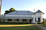 |
| 9/2/080/0015 | Old Library, Robertson | This predominantly Edwardian building was designed by the firm Tully and Waters of Cape Town and was officially opened on 28 December 1904.
The building was originally intended to commemorate King Edward VII's coronation in 1902 and to serve as a library.
|
Robertson | Robertson | Provincial Heritage Site | 33°48′07″S 19°53′15″E / 33.802065°S 19.887543°E | 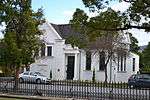 |
| 9/2/080/0016 | 58 Van Reenen Street, Robertson | Historic Robertson owes its architectural variety to, inter alia, houses in the Cape Dutch, Georgian and Victorian styles.
An example of the Victorian style, this double-storeyed house from the late nineteenth century forms an integral part of the town's |
Robertson | Robertson | Provincial Heritage Site | 33°48′10″S 19°52′55″E / 33.802678°S 19.881928°E |
|
| 9/2/080/0017 | Wolfkloof, Robertson District | Robertson | Provincial Heritage Site | 33°48′07″S 19°53′16″E / 33.801846°S 19.887872°E |  | ||
| 9/2/080/0018 | Erf 191, Barry Street, McGregor, Robertson District | McGregor | Robertson | National Monument |
| ||
| 9/2/080/0019 | Block bounded by Keerom, Long and Lady Grey Streets, McGregor | Housing scheme consisting of detached and semi-detached thatched cottages in the 'McGregor style' They have straight end gables and external chimneys, and wide eaves with exposed rafters.
Composite 6-pane wooden casements; stable doors.
Stoep enclosed
|
McGregor | Robertson | Provincial Heritage Site | 33°56′54″S 19°49′48″E / 33.948309°S 19.830112°E |  |
| 9/2/080/0020 | Erf 642, Smith Street, McGregor, Robertson District | McGregor | Robertson |
| |||
| 9/2/080/0021 | Erf 625, Mill Street, McGregor, Robertson | McGregor | Robertson | National Monument |
| ||
| 9/2/080/0022 | Nature Reserve, McGregor, Robertson District | McGregor | Robertson | National Monument |
| ||
| 9/2/080/0023 | McGregor Conservation Area, McGregor, Robertson District | McGregor | Robertson |
| |||
| 9/2/080/0024 | Victorian Posting Box, 21 Truter Street, Robertson | McGregor | Robertson | Pending Designation | 33°48′07″S 19°53′04″E / 33.801941°S 19.884401°E |
| |
| 9/2/080/0025 | Erf 23, Voortrekker Street, McGregor, Robertson District | McGregor | Robertson | Pending |
| ||
| 9/2/080/0026 | Die Ou Pasteur, Erf 55, Voortrekker Street, McGregor, Robertson | McGregor | Robertson |
| |||
| 9/2/080/0027 | Erf 163, Office Street, McGregor, Robertson District | McGregor | Robertson |
| |||
| 9/2/080/0028 | Erf 214, Loop Street, McGregor, Robertson District | McGregor | Robertson |
| |||
| 9/2/080/0029 | Old Gaol, Erf 219, Long Street, McGregor, Robertson District | McGregor | Robertson |
| |||
| 9/2/080/0030 | Erf 464, Long Street, McGregor, Robertson District | McGregor | Robertson |
| |||
| 9/2/080/0031 | Erf 390, Long Street, McGregor, Robertson District | McGregor | Robertson |
| |||
| 9/2/080/0032 | St Mary's Church, Robertson | McGregor | Robertson | 33°46′12″S 19°53′52″E / 33.769994°S 19.897808°E |
| ||
| 9/2/080/0033 | Erven 66 and 69, Bree Street, McGregor | This double-storeyed dwelling-house is a good example of the Georgian style and forms an important element of the historical centre of McGregor. | McGregor | Robertson | Provincial Heritage Site | 33°56′58″S 19°49′33″E / 33.949577°S 19.825820°E |
|
| 9/2/080/0033-001 | Mercury House, Erf 69, Bree Street, McGregor | Double storey building with IBR roof behind parapet.
Upper floor (probably later addition) has steel casements.
Ground floor has 6 x 6 sashes with internal shutters.
S/Storey extensions to either side of building.
|
McGregor | Robertson | Provincial Heritage Site | 33°56′59″S 19°49′34″E / 33.949760°S 19.826074°E |
|
| 9/2/080/0034 | Rhebokskraal, Robertson District | This gabled house dates from 1874 and is one of the best examples of the last stages of the Cape-Dutch architectural style.
Apart from the Cape-Dutch elements, this dwelling-house also has typical characteristics of the Georgian and Victorian styles, such
|
Robertson | Provincial Heritage Site | 33°48′15″S 19°53′20″E / 33.804033°S 19.888859°E |
| |
| 9/2/080/0035 | Erf 375, Plein Street, McGregor | These two cottages in the vernacular style date from the second half of the nineteenth century.
The property in its entirety forms an important architectural element of the historic centre of McGregor. |
McGregor | Robertson | Provincial Heritage Site | 33°57′08″S 19°49′24″E / 33.952244°S 19.823407°E |
|
| 9/2/080/0036 | Block bounded by Mill, Plein, Darling & Van Reenen Streets, McGregor | McGregor | Robertson | National Monument | 33°57′01″S 19°49′20″E / 33.950251°S 19.822208°E |
| |
| 9/2/080/0037 | Block bounded by Mill, Plein, Darling & Smith Streets, McGregor | McGregor | Robertson | 33°57′05″S 19°49′15″E / 33.951481°S 19.820725°E |
| ||
| 9/2/080/0037/01 | Erf 605 (Ptn old Erf 8), Plein Street, McGregor | McGregor | Robertson | National Monument |
| ||
| 9/2/080/0037/02 | Erf 606 (Ptn old Erf 8), Mill Street, McGregor | McGregor | Robertson |
| |||
| 9/2/080/0037/03 | Erf 607 (Ptn old Erf 8), Mill Street, McGregor | McGregor | Robertson |
| |||
| 9/2/080/0037/04 | Erf 608 (Ptn old Erf 8), Mill Street, McGregor | McGregor | Robertson |
| |||
| 9/2/080/0037/05 | Erf 609 (Ptn old Erf 8), Smith Street, McGregor | McGregor | Robertson |
| |||
| 9/2/080/0037/06 | Erf 610 (Ptn old Erf 8), Smith Street, McGregor | McGregor | Robertson |
| |||
| 9/2/080/0037/07 | Erf 604 (Ptn old Erf 8), Plein Street, McGregor | McGregor | Robertson |
| |||
| 9/2/080/0038 | Municipal offices, Erf 81, Voortrekker Street, McGregor | Two buildings, attached.
The left is single storey under thatch, central gable dated 1876.
Straight end parapets, central front double door with fanlight, new 3x2 sashes with half shutters.
2 new single solid doors with fanlights.
Quarry tile cills to The Municipal Offices are situated in the centre of McGregor and consists of a gabled house and a Georgian annex, both of which date from about 1870.
The gabled house is a representative example of the last flickering of the Cape Dutch architectural style.
|
McGregor | Robertson | Provincial Heritage Site | 33°57′05″S 19°49′26″E / 33.951399°S 19.823965°E |
|
| 9/2/080/0039 | Dutch Reformed Church, Erf 48, Church Street, McGregor | Imposing church building, cruciform plan with tower inserted between the two street wings.
Straight end gables to the end of each wing, with moulded parapets and decorative mouldings applied to gable walls.
Large arched timber windows set above smaller p
|
McGregor | Robertson | Provincial Heritage Site | 33°55′51″S 19°49′22″E / 33.930920°S 19.822790°E | 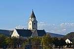 |
| 9/2/080/0040 | Remainder of Erf 600, Bree Street, McGregor | McGregor | Robertson | National Monument |
| ||
| 9/2/080/0041 | Erf 798, Bree Street, (Ptn of Erf 600), McGregor | McGregor | Robertson |
| |||
| 9/2/080/0042 | Erf 659, Darling Street, McGregor | McGregor | Robertson |
| |||
| 9/2/080/0043 | Erf 601, Bree Street, McGregor | McGregor | Robertson |
| |||
| 9/2/080/0044 | Erf 645, (Ptn of Erf 100), Voortrekker Street, McGregor | McGregor | Robertson | National Monument |
| ||
| 9/2/080/0045 | Erf 605, Plein Street, McGregor | McGregor | Robertson | National Monument |
| ||
| 9/2/080/0046 | Erf 606, Mill Street, McGregor | McGregor | Robertson |
| |||
| 9/2/080/0047 | Erf 602, Darling Street, McGregor | McGregor | Robertson |
| |||
| 9/2/080/0048 | Erf 657 Darling Street, McGregor | McGregor | Robertson |
| |||
| 9/2/080/0049 | Erf 106, Tindall Street, McGregor | Vernacular cottage with reed thatch, triangular end gables and external chimney.
4-pane and single-pane casements.
Stable door.
|
McGregor | Robertson | Register | 33°56′50″S 19°49′43″E / 33.947288°S 19.828749°E |
|
| 9/2/080/0050 | ROBERTSON MAGISTERIAL DISTRICT GENERAL | Robertson | Robertson |
| |||
| 9/2/080/0051 | 14 Truter Street, Robertson | Robertson | Robertson | 33°48′13″S 19°53′12″E / 33.803517°S 19.886788°E |
| ||
| 9/2/080/0052 | Erf 371 & Ptn 316 (now 476-503), cnr Long & Keerom Sts, McGregor | McGregor | Robertson | Apply for Declaration | 33°56′40″S 19°50′03″E / 33.944554°S 19.834171°E |
|
References
- ↑ "Western Cape Provincial Heritage Sites (previously National Monuments)" (PDF). 19 September 2002. Retrieved 2013-01-28.
| Wikimedia Commons has media related to Cultural heritage monuments in Western Cape. |
Lists of South African Heritage Resources | ||||||||||||||||||||||||||||||||||||
|---|---|---|---|---|---|---|---|---|---|---|---|---|---|---|---|---|---|---|---|---|---|---|---|---|---|---|---|---|---|---|---|---|---|---|---|---|
| SAHRA Heritage sites |
| |||||||||||||||||||||||||||||||||||
| World heritage sites | ||||||||||||||||||||||||||||||||||||