List of heritage sites in North West
This is a list of the heritage sites in the North West province of South Africa, as recognized by the South African Heritage Resources Agency.
| SAHRA identifier | Site name | Description | Town | District | NHRA status | Coordinates | Image |
|---|---|---|---|---|---|---|---|
| 9/2/103/0003 | Tiger Kloof, Waterloo 730, District Vryburg | Type of site: Educational. | Vryburg | Provincial Heritage Site | 27°03′20″S 24°45′20″E / 27.0555555555°S 24.755556°ETiger Kloof, Waterloo 730, District Vryburg) | 
| |
| 9/2/103/0004 | Old Police Station, 9 Vry Street, Vryburg | Type of site: Police Station Current use: Residential: House. The Old Police Station is probably the earliest remaining building in Vryburg, and almost intact an example of an early humble public building erected at the time that the town was established. The building was sold to MC Genis the magistrate of the Boer | Vryburg | Vryburg | Provincial Heritage Site | 26°57′37″S 24°43′49″E / 26.9603944444°S 24.730414°E |
|
| 9/2/103/0005 | Dutch Reformed Church Parsonage, 85 Vry Street, Vryburg | Fine Victorian residence with complex roof, forward projecting bay on one side, and truncated corner At the church council meeting held on 3 June 1911 it was decided "die tyd gekomen is om en nieuw Pastorie te bouwen". Two erven were bought from J West for £550 and the parsonage built thereon. The parsonage was completed at a total cost of £2,792 5s of w Architectural style: Edwardian. Type of site: Parsonage Current use: Residential: House. Intrinsic aesthetic/architectural merit. | Vryburg | Vryburg | Register | 26°57′37″S 24°43′49″E / 26.9603944444°S 24.730406°E |
|
| 9/2/103/0007 | St Stephens Anglican Church, MacKenzie Street, Vryburg | Rectangular form church building with semi-circular baptistry addition at the rear. Original roofing Consecrated in 1891. Regularly attended by soldiers during the Anglo-Boer War Type of site: Church Current use: Religious: Church. Outstanding aesthetic/architectural merit | Vryburg | Vryburg | Provincial Heritage Site | 26°57′21″S 24°44′16″E / 26.955710°S 24.737881°E |
|
| 9/2/212/0003 | Preller House, Rondavelhouse and Cemetery, Pelindaba, Brits District | This dwelling, consisting of three stone rondavels, was built by Gustav Preller in 1920 and was initially used as a week-end residence. Dr Preller also placed the rondavels at the disposal of Afrikaans writers and artists. Type of site: Cemetery, House. Gustav Preller, the well-known protagonist of Afrikaans, historian and journalist built and occupied this house from 1935 until his death. Many of his later historical works were completed in this house.
This dwelling, consisting of three stone rondavel |
Brits | Provincial Heritage Site | 25°47′56″S 27°54′25″E / 25.799007°S 27.906893°E |  | |
| 9/2/212/0005 | Historical Houses, Karee Road, Brits | Type of site: House. | Brits | Brits | Provisional Protection | 25°38′04″S 27°46′52″E / 25.634444°S 27.781111°E |
|
| 9/2/212/0006 | Fourie House No. 1, De Kroon, Brits District | Brits | Plaque | 25°39′19″S 27°47′52″E / 25.655206°S 27.797717°E |
| ||
| 9/2/212/0016 | Gondolin, Broederstroom 481 JQ, North West | Current use: Research. This series of fossil sites is one of the most important in the world for the study of human evolution in the context of changing ecological and biological processes. Collectively, they are of national and international significance because they encapsula | Brits | National Heritage Site | 26°02′57″S 28°05′17″E / 26.04917°S 28.08806°E |
| |
| 9/2/212/0017 | Preller House, Main House, Welgegund, Pelindaba, Brits District | Type of site: House. Gustav Preller, the well-known protagonist of Afrikaans, historian and journalist built and occupied this house from 1935 until his death. Many of his later historical works were completed in this house.
This dwelling, consisting of three stone rondavel |
Brits | Provincial Heritage Site | 25°47′56″S 27°54′25″E / 25.798982°S 27.906926°E |  | |
| 9/2/218/0003 | Dutch Reformed Church, Delarey Street, Delareyville | Type of site: Church. | Delareyville | Delareyville | Provincial Heritage Site | 26°41′12″S 25°27′28″E / 26.686702°S 25.457911°E |
|
| 9/2/231/0001 | Wood and Iron Houses 13 and 15 Convent Avenue, Klerksdorp | Type of site: Residence. | Klerksdorp | Klerksdorp | Provincial Heritage Site | 26°52′00″S 26°40′00″E / 26.866667°S 26.666667°E | 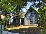 |
| 9/2/231/0002 | Fountain Villa, Hendrik Potgieter Street, Klerksdorp | Type of site: House. | Klerksdorp | Klerksdorp | Provincial Heritage Site | 26°52′11″S 26°39′12″E / 26.869858°S 26.653292°E | 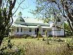 |
| 9/2/231/0003 | Railway Station, Delver Street, Klerksdorp | This railway station building was completed in 1897 by the Nederlandsche Zuid-Afrikaansche Spoorweg-Maatchappij and is one of only a few elegant station buildings erected by the NZASM. For approximately nine years the Klerksdorp Station remained the west Type of site: Railway Station. This railway station building was completed in 1897 by the Nederlandsche Zuid-Afrikaansche Spoorweg-Maatschappij and is one of only a few elegant station buildings erected by the NZASM. For approximately nine years the Klerksdorp Station remained the west | Klerksdorp | Klerksdorp | Provincial Heritage Site | 26°52′11″S 26°39′54″E / 26.869739°S 26.664972°E |  |
| 9/2/231/0009 | Nederduits Gereformeerde Mother Church, Anderson Street, Klerksdorp | Type of site: Church. | Klerksdorp | Klerksdorp | Provincial Heritage Site | 26°52′03″S 26°39′58″E / 26.867632°S 26.665992°E |  |
| 9/2/231/0012 | Farmhouse, Renosterspruit, Klerksdorp District | Type of site: Farm Complex. This simple farmhouse was built immediately after 1903 by Jakobus Badenhost who participated in the Anglo-Boer War (1899-1902) and whose original house was burnt down during the war. Therefore the house stands as a symbol of the above-mentioned war and c | Klerksdorp | Register | 27°02′08″S 26°30′24″E / 27.035521°S 26.506791°E |
| |
| 9/2/235/0005 | Nerderduitse Gereformeerde Church, 27 Gerrit Maritz Street, Lichtenburg | The corner stone of this stone building was laid on 14 June 1890. In 1928, under the direction of Gerhard Moerdyk, the building was substantially enlarged and the striking portico and spire were added. During the Anglo-Boer War (1899-1902) the building w Type of site: Church. The corner stone of this stone building was laid on 14 June 1890. In 1928, under the direction of Gerhard Moerdyk, the building was substantially enlarged and the striking portico and spire were added. During the Anglo-Boer War (1899-1902) the building w | Lichtenburg | Lichtenburg | Provincial Heritage Site | 26°08′57″S 26°09′54″E / 26.1492805555°S 26.164903°E |
|
| 9/2/235/0008 | Historic cattle dip, Elandsputte, Lichtenburg District | In December 1924, during the construction of this cattle-dip, Mr J. A. Voorendyk discovered a diamond which led to the further discovery of diamonds on Elandsputte (a portion of Uitgevonden) and the eventual spectacular "diamond rushes" on Elandsputte in1 Type of site: Cattle Dip. In December 1924, during the construction of this cattle-dip, Mr J. A. Voorendyk discovered a diamond which led to the further discovery of diamonds on Elandsputte (a portion of Uitgevonden) and the eventual spectacular "diamond rushes" on Elandsputte in1 | Lichtenburg | Provincial Heritage Site | 25°58′26″S 26°05′46″E / 25.973926°S 26.096123°EHistoric cattle dip, Elandsputte, Lichtenburg District) |
| |
| 9/2/235/0012 | Dutch Reformed Church, Ottosdal | Type of site: Church. | Ottosdal | Lichtenburg | Register | 26°49′15″S 26°00′21″E / 26.820706°S 26.005922°E |
|
| 9/2/235/0014 | Ou Plaas Guest House, Holfontein 147, Lichtenburg District | Type of site: House. This house attaches its significance from the fact that it is the only remnant of the builder Scribante in the Lichtenburg District that dates immediately after the Anglo-Boer War (1899-1902). Furthermore, it satisfies the criteria for the declaration of | Lichtenburg | Register | 26°49′31″S 26°00′10″E / 26.825343°S 26.002772°E |
| |
| 9/2/238/0002 | Bokkraal, Marico District | Marico | Provisional Protection | 25°49′02″S 26°27′56″E / 25.817169°S 26.465614°E |
| ||
| 9/2/238/0006-001 | Church of St John the Baptist, Zeerust, Marico District | This Church was built in 1873. It was the third Anglican Church to be built in the Transvaal and is the oldest still standing. Type of site: Church. This Church was built in 1873. It was the third Anglican Church to be built in the Transvaal and is the o1dest still standing. | Zeerust | Marico | Provincial Heritage Site | 25°32′00″S 26°05′00″E / 25.533333°S 26.083333°E |
|
| 9/2/238/0012 | Kaditshwene Cultural landscape (ruins) | STATEMENT OF SIGNIFICANCE
Kaditshwene is historically considered a capital of the Bahurutshe nation and the largest Batswana settlement in Southern Africa with a population of 16000 to 20000, around the early 1800s. The large population of Kaditshwene i |
Northe West, Zeerust | Marico | National Heritage Site | 25°20′30″S 26°10′05″E / 25.3416666666°S 26.168056°EKaditshwene Cultural landscape (ruins)) |
|
| 9/2/238/0015 | Water mill, Malmani Eye, Marico District | This water-wheel and mill of cast iron is one of only a few water-mills in the Transvaal which have been preserved in situ. It was probably erected sometime between 1900 and 1910 and is representative of the last type of mills in South Africa that operate Type of site: Water Mill. This water-wheel and mill of cast iron is one of only a few water-mills in the Transvaal which have been preserved in situ. It was probably erected sometime between 1900 and 1910 and is representative of the last type of mills in South Africa that operate | Marico | Provincial Heritage Site | 25°49′32″S 26°02′58″E / 25.825561°S 26.049485°E |
| |
| 9/2/256/0001 | Old powder magazine, Wolmarans Street, Potchefstroom | This powder magazine was erected between 1841 and 1863 and is as such one of the oldest existing buildings in Potchefstroom. This stone building played an important role from the time of its construction, especially during the First War of Independence. Type of site: Powder Magazine. This powder magazine was erected between 1841 and 1863 and is as such one of the oldest existing buildings in Potchefstroom. This stone building played an important role from the time of its construction, especially during the First War of Independence. | Potchefstroom | Potchefstroom | Provincial Heritage Site | 26°42′56″S 27°05′09″E / 26.715571°S 27.085698°E |
|
| 9/2/256/0002 | 74 James Moroka Ave (old street name:Lombard Street), Potchefstroom | Type of site: Residence. | Potchefstroom | Potchefstroom | Provincial Heritage Site | 26°46′36″S 26°50′59″E / 26.7767805555°S 26.849775°E | 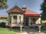 |
| 9/2/256/0003 | 76 James Moroka Ave (old street name:Lombard Street), Potchefstroom | Type of site: Residence. | Potchefstroom | Potchefstroom | Provincial Heritage Site | 26°46′36″S 26°50′59″E / 26.7767805555°S 26.849742°E |  |
| 9/2/256/0004 | 72 James Moroka Ave (old street name:Lombard Street), Potchefstroom | Potchefstroom | Potchefstroom | Provincial Heritage Site | 26°46′36″S 26°50′59″E / 26.7767722222°S 26.849742°E |  | |
| 9/2/256/0005 | Old Berlin Mission Station, Sol Plaatjie Ave (old street name:Gouws Street), Potchefstroom | Type of site: Mission Station. This building-complex is one of the rare and most important historical building complexes ever to be found in Potchefstroom. This mission station was established in 1872 by Pastor CW Moschutz of the Berlin Mission Society and presently creates the most i | Potchefstroom | Potchefstroom | Provincial Heritage Site | 26°42′52″S 27°05′49″E / 26.714530°S 27.097048°E |
|
| 9/2/256/0007-001 | House of President M W Pretorius, Thabo Mbeki Drive (old street name:Van der Hoff Avenue), Potchefstroom | In the course of the second half of the nineteenth century Marthinus Wessel Pretorius played a very important role in the history of the Zuid-Afrikaansche Republiek and the Republic of the Orange Free State. After the death of his father, A. W. J. Pretori Type of site: House. Marthinus Wessel Pretorius, Commandant-General of Rustenburg and Potchefstroom (1853-1857), State President of the South African Republic (1857-1860 and 1964-1871), State President of the Republic of the Orange Free State (1860-1863) and member of the Tri | Potchefstroom | Potchefstroom | Provincial Heritage Site | 26°41′34″S 27°05′51″E / 26.692904°S 27.097390°E |  |
| 9/2/256/0008 | Old Fort and Cemetery, Potchefstroom | An old earth fort and a cemetery. (A stone monument in memory of the siege victims was erected in the adjoining cemetery.) This old earthwork or fort is situated a few hundred metres south of the Potchefstroom railway station. Its origin is a mystery, for when it became of historical importance during the First Transvaal War of Independence, it was already old.
In 1877 Great Type of site: Fort, Cemetery. |
Potchefstroom | Potchefstroom | Provincial Heritage Site | 26°42′59″S 27°05′10″E / 26.716447°S 27.086190°E |  |
| 9/2/256/0010 | Dutch Reformed Church, Church Street, Potchefstroom | This fine old church of the Nederduits Hervormde congregation of Potchefstroom, the first Voortrekker congregation in the Transvaal, stands on Church Square opposite the Town Hall in the heart of the town.
Towards the end of 1838 Commandant A. H. Potgiete Type of site: Church. This fine church is the second church building of the “Voortrekker congregation of Transvaal" of the Dutch Reformed (Nederduits Hervormde) Church. The church was taken into use on 24 February 1866. |
Potchefstroom | Potchefstroom | Provincial Heritage Site | 26°42′36″S 27°05′52″E / 26.709930°S 27.097790°E |  |
| 9/2/256/0011 | Old Police Station, Greyling Street, Potchefstroom | Type of site: Police Station. | Potchefstroom | Potchefstroom | Provincial Heritage Site | 26°42′51″S 27°05′44″E / 26.714160°S 27.095440°E | 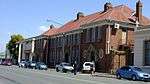 |
| 9/2/256/0012 | Old Post Office, Greyling Street, Potchefstroom | Type of site: Post Office. | Potchefstroom | Potchefstroom | Provincial Heritage Site | 26°42′51″S 27°05′44″E / 26.714160°S 27.095440°E | 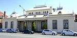 |
| 9/2/256/0014 | Oak Avenue, Potchefstroom | This oak avenue was planted in about 1910 and lends to the streets along which it is situated both dignity and aesthetic character. Type of site: Avenue, Tree. This oak avenue was planted in about 1910 and lends to the streets along which it is situated both dignity and aesthetic character. | Potchefstroom | Potchefstroom | Provincial Heritage Site | 26°42′52″S 27°05′49″E / 26.714530°S 27.097048°E | 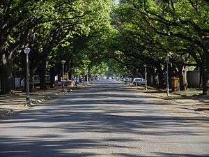 |
| 9/2/256/0015 | St Mary's Anglican Church, Auto Avenue, Potchefstroom | Single storey, square form. Pitched corrugated iron roofsheeting. Claybricks wall, plastered with cl Type of site: House Current use: House. The Anglican church, built in 1890-91, in the Neo-Gothic style, was the first building in Potchefstroom resembling this historic Neo-Gothic style. The parish in Potchefstroom is one of the oldest in the Transvaal. | Potchefstroom | Potchefstroom | Provincial Heritage Site | 26°42′45″S 27°05′46″E / 26.712504°S 27.096239°E | 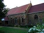 |
| 9/2/256/0018 | Krugerskraal, Tygerfontein, Potchefstroom District | Potchefstroom | Provincial Heritage Site | 26°53′00″S 27°13′00″E / 26.883333°S 27.216667°E |
| ||
| 9/2/256/0020 | Town Hall, Potgieter Street, Potchefstroom | Type of site: Town Hall. | Potchefstroom | Potchefstroom | Provincial Heritage Site | 26°42′49″S 27°05′29″E / 26.713550°S 27.091250°E |  |
| 9/2/256/0021 | Carnegie Library, Walter Sisulu Avenue (old street name:Potgieter Street), Potchefstroom | Type of site: Library. | Potchefstroom | Potchefstroom | Provincial Heritage Site | 26°42′49″S 27°05′29″E / 26.713550°S 27.091250°E | 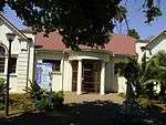 |
| 9/2/256/0024 | Historic Reformed Church Complex, eet, Potchefstroom | In 1905 the Theological School of the Gereformeerde Church was transferred from Burgersdorp to Potchefstroom where from 1905 to 1907 this complex of four buildings was erected to accommodate the Theological School and its subsections, the professor and th Type of site: Church Complex. In 1905 the Theological School of the Gereformeerde Church was transferred from Burgersdorp to Potchefstroom where from 1905 to 1907 this complex of four buildings was erected to accommodate the Theological School and its subsections, the professor and th | Potchefstroom | Potchefstroom | Provincial Heritage Site | 26°41′37″S 27°05′47″E / 26.693655°S 27.096437°E |  |
| 9/2/256/0025 | Voortrekker Fort, Elandsfontein, Potchefstroom District | The fort was built of stone and was about 24 m long and 12 m wide with embrasures at the corners to provide enfilading fire. The walls must have been about 1,5 m high. There are two roads that lead to Fochville from the national road between Johannesburg and Potchefstroom. The more southerly of these roads, the main route from Potchefstroom to Fochville, crosses the farm Elandsfontein where the ruins of this Voortrekker Type of site: Fort. According to tradition this stone fort was built by the Voortrekkers under the leadership of Andries Hendrik Potgieter. It was presumably erected in 1842 to serve as a shelter for the women and children in case the men had to leave for Port Natal to assis | Elandsfontein | Potchefstroom | Provincial Heritage Site | 26°42′52″S 27°05′49″E / 26.714530°S 27.097048°EVoortrekker Fort, Elandsfontein, Potchefstroom District) |
|
| 9/2/256/0028 | Old Fire Brigade Station, Kock Street, Potchefstroom | Type of site: Civic. | Potchefstroom | Potchefstroom | Provisional Protection | 26°42′59″S 27°05′18″E / 26.716361°S 27.088440°E | 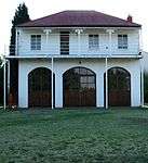 |
| 9/2/256/0030 | Potchefstroom Agricultural College, Potchefstroom | Both the Administration Building, which was the first building of the Potchefstroom College of Agriculture to be erected and which was occupied in 1907, and the Selborne Hall in which the Africander Cattle Breeders' Society was established in 1912, are cl Type of site: Educational. Both the Administration Building, which was the first building of the Potchefstroom College of Agriculture to be erected and which was occupied in 1907, and the Selborne Hall in which the Africander Cattle Breeders' Society was established in 1912, are cl | Potchefstroom | Potchefstroom | Provincial Heritage Site | 26°42′55″S 27°05′47″E / 26.715306°S 27.096341°E |
|
| 9/2/256/0031 | Old Reformed Church, Maury Avenue, Potchefstroom | The Gereformeerde Congregation of Potchefstroom is one of the first seven congregations of the Gereformeerde Kerk founded in 1859 in the Rustenburg area, Transvaal; In July of the same year the church congregation petitioned the government of the then Zu Type of site: Church. This small church with its Gothic Features was erected between 1865 and 1866. It was designed by Rev. Dirk Postma, first minister of the Gereformeerde Kerk in South Africa. It is one of the first churches built by the Gereformeerde Kerk. This simple w | Potchefstroom | Potchefstroom | Provincial Heritage Site | 26°42′21″S 27°05′47″E / 26.705835°S 27.096506°E |  |
| 9/2/256/0032 | W D Pretorius House, Church Street, Potchefstroom | Potchefstroom | Potchefstroom | Provincial Heritage Site | 26°42′36″S 27°05′52″E / 26.709930°S 27.097790°E |
| |
| 9/2/256/0033 | Heimat, Potchefstroom University for Christian Higher Education, Potchefstroom | Both these buildings represent important milestones in the history of the development of the Potchefstroomse Universiteit vir Christelike Hoer Onderwys. The neo-Cape Dutch building known as Heimat, designed by Gerard Moerdijk and completed as a students’ Type of site: Educational. Both these buildings represent important milestones in the history of the development of the Potchefstroomse Universiteit vir Christelike Hoer Onderwys. The neo-Cape Dutch building known as Heimat, designed by Gerard Moerdijk and completed as a students’ | Potchefstroom | Potchefstroom | Provincial Heritage Site | 26°42′52″S 27°05′49″E / 26.714530°S 27.097048°E |
|
| 9/2/256/0034 | Old Magistrate's Office, Greyling Street, Potchefstroom | Type of site: Magistrates Office. | Potchefstroom | Potchefstroom | Provincial Heritage Site | 26°42′51″S 27°05′44″E / 26.714160°S 27.095440°E | 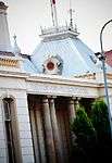 |
| 9/2/256/0035 | Goetz-Fleischack House, Sol Plaatjie Ave (old street name:Gouws Street), Potchefstroom | The restored Goetz-Fleischack House was erected for A M. Goetz, Resident Magistrate of Potchefstroom, between 1860 and 1863 and is today the only so-called Karroo-style house in Potchefstroom that has maintained its original appearance. Together with the Type of site: House Previous use: Residential. Current use: Museum. The restored Goetz-Fleischack House was erected for A M. Goetz, Resident Magistrate of Potchefstroom, between 1860 and 1863 and is today the only so-called Karroo-style house in Potchefstroom that has maintained its original appearance. Together with the | Potchefstroom | Potchefstroom | Provincial Heritage Site | 26°42′52″S 27°05′49″E / 26.714530°S 27.097048°E | 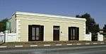 |
| 9/2/256/0037 | Superintendent's Residence, Witrand Care and Rehabilitation Centre, Potchefstroom | This house was erected after the Anglo-Boer War as the official residence for the officer commanding the British garrison at Potchefstroom, and formed part of the military cantonments there. It is an important link with Potchefstroom's military past and s Type of site: Residence. This house was erected after the Anglo-Boer War as the official residence for the officer commanding the British garrison at Potchefstroom, and formed part of the military cantonments there. It is an important link with Potchefstroom's military past and s | Potchefstroom | Potchefstroom | Provincial Heritage Site | 26°42′52″S 27°05′49″E / 26.714530°S 27.097048°E |
|
| 9/2/256/0039 | Farmstead, Buffelsdoorn, Potchefstroom District | Type of site: Farm Complex. The house which dates from the Transvaal pioneering Era, is of historical importance due to its connection with Philippus Jacobus Wilhelmus Schutte who was the owner of the farm Buffelsdoorn from 1856 until his death in 1873. Schutte was a leading figure | Potchefstroom | Register | 26°28′50″S 27°21′54″E / 26.480505°S 27.365060°E |
| |
| 9/2/256/0040 | Roets House, 61 Steve Biko Avenue (old street name:Tom Street), Potchefstroom | The house is vacant at the moment, but the Potchefstroom University intends using it as a laboratory for medical practitioners. Therefore due to the building's unique architectural features most especially to its immediate environment the architectural | Potchefstroom | Potchefstroom | Register | 26°42′52″S 27°05′49″E / 26.714530°S 27.097048°E | 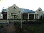 |
| 9/2/256/0041 | The Northern Wing of the Nutrition and Family Ecology Building of the Potchefstroom University | Provincial Heritage Site | 26°42′52″S 27°05′49″E / 26.714530°S 27.097048°E |
| |||
| 9/2/256/0042 | Rectors Residence, 1 Calderbank Avenue, Potchefstroom | Type of site: Residence. The house which was erected in 1942 and designed by the architect Hugh Roberts, is a landmark in Potchefstroom. Historically it is important for its association with Hugh Calderbank who was the Mayor of Potchefstroom in the early 1940s. The building als | Potchefstroom | Potchefstroom | Register | 27°05′45″S 26°40′52″E / 27.0959444444°S 26.681119°E | 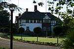 |
| 9/2/263/0002 | Dutch Reformed Church, Fatima Bhayat St (Plein Street) , Rustenburg | Construction on this neo-Gothic church building started in 1898, but owing to the outbreak of the Anglo-Boer War the finishing touches could only be done in 1903. During the war the building was used by the British as a hospital and it is alleged that six Type of site: Church. Construction on this neo-Gothic church building started in 1898, but owing to the outbreak of the Anglo-Boer War the finishing touches could only be done in 1903. During the war the building was used by the British as a hospital and it is alleged that six | Rustenburg | Rustenburg | Provincial Heritage Site | 25°40′19″S 27°14′43″E / 25.671818°S 27.245247°E |  |
| 9/2/263/0004 | Old Lutheran School (Library), Kroondal, Rustenburg District | Type of site: School. This plain little building was completed early in 1898 as the first permanent school building at Kroondal. Together with the nearby Old Lutheran Church it forms the historical core of the town of Kroondal. | Rustenburg | Provincial Heritage Site | 25°39′16″S 27°15′21″E / 25.654448°S 27.255854°E |  | |
| 9/2/263/0005 | Schoch House, Boschdal, Rustenburg district | Rustenburg | Provincial Heritage Site | 25°39′16″S 27°15′21″E / 25.654448°S 27.255854°E |
| ||
| 9/2/263/0007 | Boekenhoutfontein, Rustenburg District | President Paul Kruger’s house on his farm Boekenhoutfontein still stands on the slope of a tree-covered hill at the foot of the Magaliesberg mountains, 20 km west of Rustenburg.
At the end of 1840 several Voortrekkers settled in the fertile valley between. From 1862 to 1903 the farm was the property of State President S. J. P. Kruger. |
Rustenburg | Provincial Heritage Site | 25°39′16″S 27°15′21″E / 25.654448°S 27.255854°EBoekenhoutfontein, Rustenburg District) |  | |
| 9/2/263/0008 | Old Lutheran Church, Kroondal, Rustenburg district | Since 1889 Kroondal has been the centre of the Hermannsburg Missionary Society's activities in South Africa and construction on this quaint eclectic church started in 1895. It was the first church building at Kroondal and was inaugurated on 24 June 1896. Type of site: Church. Since 1889 Kroondal has been the centre of the Hermannsburg Missionary Society's activities in South Africa and construction on this quaint eclectic church started in 1895. It was the first church building at Kroondal and was inaugurated on 24 June 1896. | Rustenburg | Rustenburg | Provincial Heritage Site | 25°39′16″S 27°15′21″E / 25.654448°S 27.255854°E |  |
| 9/2/263/0014 | Old Anglican Church, Cnr of Oliver Tambo and Beyers Naude Dr (Van Stadens Street) , Rustenburg | This Church was reconstructed on its present site in 1967. It was originally built in 1871 as a result of the efforts of John Pilkington Richardson and is one of the oldest Anglican Churches in the Transvaal. Type of site: Church. This Church was reconstructed on its present site in 1967. It was originally built in 1871 as a result of the efforts of John Pilkington Richardson and is one of the oldest Anglican Churches in the Transvaal. | Rustenburg | Rustenburg | Provincial Heritage Site | 25°40′14″S 27°14′46″E / 25.670476°S 27.246206°E | 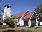 |
| 9/2/263/0016 | Syringa Tree Monument, Church Street, Rustenburg | In Rustenburg, in Church Street, just off the main road, there is a sawn-off stump of an ancient syringa tree. Under this tree, on 10 and 11 February 1859, the Reformed Church in South Africa, one of the largest Afrikaans religious organisations, cam Type of site: Tree. | Rustenburg | Rustenburg | Provincial Heritage Site | 25°40′05″S 27°14′39″E / 25.668167°S 27.244092°E |  |
| 9/2/286/0005 | Ruins of Rev. Broadbent's House, Leeuwfontein, Wolmaransstad | Wolmaransstad is situated near the south western boundary of the Transvaal; Witpoort lies 16 km to the north east of Wolmaransstad on the road to Leeudoringstad. There, on the northern part of the farm Leeuwdoorn, the first mission station in the Transvaal. | Wolmaransstad | Provincial Heritage Site | 27°13′00″S 25°58′00″E / 27.216667°S 25.966667°E |
| |
| 9/2/286/0006 | Thomas Leask House, 46 Broadbent Street, Wolmaransstad | Type of site: House Current use: Guest House. The house derives its historical significance from its association with its previous owner, Thomas Spence Leask, well known as the "Father of Wolmaransstad". The alteration which were made in the 1880s and after 1900 to the original house which was bult | Wolmaransstad | Wolmaransstad | Register | 27°12′20″S 25°58′53″E / 27.205452°S 25.981255°E |
|
| 9/2/501/0015 | Cannon , Mafikeng | Mafeking is situated in the northernmost corner of the Cape Province. On rising ground about a kilometre to the south-west of the town there is a very interesting fort known as ""Kanonkoppie"".
In 1882 the Boers in this vicinity established two small repu . The Fort on Cannon Kopje was originally built by Sir Charles Warren in 1884. During the Anglo-Boer War it played an important part in the siege of Mafeking. |
Mafikeng | Mafikeng | Provincial Heritage Site | 25°51′22″S 25°38′25″E / 25.855978°S 25.640310°E |
|
| 9/2/501/0016 | Warren's Fort, Old Imperial Reserve, Mafikeng | This imposing stone fortification was erected about 1880. The fort played an important role in the Anglo-Boer War. Type of site: Fort. This imposing stone fortification was erected about 1880. The fort played an important role in the Anglo-Boer War. | Mafikeng | Mafikeng | Provincial Heritage Site | 25°51′32″S 25°37′44″E / 25.858820°S 25.628821°E |
|
| Dr Livingstone's House, Marico District | Ruins of the house of Dr. Livingstone, and a cairn. This is site on which the ruin of Dr. Livingstone's house is situated. It is also where Dr. Livingstone established his second mission station (1846-1847). | Marico | Marico |
| |||
| Haasgat, Leeuwenkloof 480 JQ, North West | Current use: Research. This series of fossil sites is one of the most important in the world for the study of human evolution in the context of changing ecological and biological processes. Collectively, they are of national and international significance because they encapsula | Brits | National Heritage Site |
|
References
| Wikimedia Commons has media related to Cultural heritage monuments in North West (South African province). |
Lists of South African Heritage Resources | ||||||||||||||||||||||||||||||||||||
|---|---|---|---|---|---|---|---|---|---|---|---|---|---|---|---|---|---|---|---|---|---|---|---|---|---|---|---|---|---|---|---|---|---|---|---|---|
| SAHRA Heritage sites |
| |||||||||||||||||||||||||||||||||||
| World heritage sites | ||||||||||||||||||||||||||||||||||||