List of heritage sites in Mpumalanga
This is a list of the heritage sites in Mpumalanga as recognized by the South African Heritage Resources Agency.
| SAHRA identifier | Site name | Description | Town | District | NHRA status | Coordinates | Image |
|---|---|---|---|---|---|---|---|
| 4/T/BAR/1 | Guard House, Corner Lee Road and Judge Street, Barberton | This wood and corrugated iron guard house was erected during 1901 to protect the concentration camp, the camp hospital and the town during the Anglo-Boer War. It is probably the only surviving blockhouse of its kind. Type of site: Guardhouse. This wood and corrugated iron guard house was erected during 1901 to protect the concentration camp, the camp hospital and the town during the Anglo- Boer War. It is probably the only surviving blockhouse of its kind. | Barberton | Barberton | Provincial Heritage Site | 25°47′26″S 31°03′24″E / 25.790571°S 31.056678°E |  |
| 9/2/203/0001 | NZASM Railway Bridge, Komatipoort, Barberton District | Type of site: Bridge. | Barberton | Barberton | Provincial Heritage Site | 25°26′43″S 31°57′37″E / 25.445375°S 31.960164°E | 
|
| 9/2/203/0002 | Stopforth House, Bowness Street, Barberton | This well-preserved dwelling-house and outbuildings of wood and iron were erected by J. S. Stopforth during the eighties of the previous century. The building complex has remained unaltered and it therefore provides an important cultural-history link with Type of site: House. This well-preserved dwelling-house and outbuildings of wood and iron were erected by J. S. Stopforth during the eighties of the previous century. The building complex has remained unaltered and it therefore provides an important cultural-history link with | Barberton | Barberton | Provincial Heritage Site | 25°47′34″S 31°03′16″E / 25.792661°S 31.054366°E |  |
| 9/2/203/0003 | Belhaven House Museum, Lee Road, Barberton | The House is well preserved. Wood and corrugated iron construction. Kitchen and pantry of sunburnt earth bricks. T. and G. Baltic Pine 150 mm wide floor loards. Verandah with wooden wall and fretwork. All ceilings and walls in main part of house of press The first inhabitants of Belhaven were the Nisbet family. Kathleen Maud Nisbet had formerly been Mrs. Kinñeburgh, who in 1890 worked at the ""American Bar"" in Barberton. On 8 October 1891, she married Mr. A. R. Simmons, a Surgeon-dentist who had coma to Current use: Museum. | Barberton | Barberton | Provincial Heritage Site | 25°47′27″S 31°03′24″E / 25.790818°S 31.056542°E | 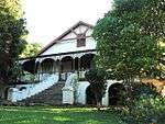 |
| 12/T/PIL/5 | Horseshoe Water Fall, Graskop, Pilgrim's Rest District | This waterfall and the basin into which it gradually cascades, as well as the banks of the basin with the surrounding cliffs covered in indigenous plants, form an essential part of the natural beauty of this area. Type of site: Waterfall. This waterfall and the basin into which it gradually cascades, as well as the banks of the basin with the surrounding cliffs covered in indigenous plants, form an essential part of the natural beauty of this area. | Pilgrim's Rest | Provincial Heritage Site | 25°07′50″S 30°41′41″E / 25.130516°S 30.694685°E |
| |
| 9/2/203/0004 | Globe Tavern, Pilgrim Street, Barberton | This former tavern was opened in 1887, two and half years after Barberton was founded. It is typical of the wood and iron buildings which characterised the gold-fields of the Eastern Transvaal during the last quarter of the previous century and is an impo. This former tavern was opened in 1887, two and half years after Barberton was founded. It is typical of the wood and iron buildings which characterised the gold-fields of the Eastern Transvaal during the last quarter of the previous century and is an impo | Barberton | Barberton | Provincial Heritage Site | 25°47′30″S 31°03′16″E / 25.791624°S 31.054353°E |
|
| 9/2/203/0008 | Old Stock Exchange, Pilgrim Street, Barberton | Only the walls of Barberton’s stock exchange, one of the first stock exchange buildings in South Africa, are preserved. They stand next to the library in Pilgrim Street.
This stock exchange building reminds one of the time in the history of the Eastern Tr Type of site: Stock Exchange. This building was the second Stock Exchange built in Barberton. It was built by the De Kaap Gold Fields Stock Exchange Limited, and opened on 13 April 1887. |
Barberton | Barberton | Provincial Heritage Site | 25°47′29″S 31°03′14″E / 25.791526°S 31.053756°E |  |
| 9/2/203/0009 | ETC Building, Pilgrim Street, Barberton | This office building, which was completed for Sammy Marks early in 1887, dates from Barberton's boom period and is an important link with old Barberton. It is thought to be the oldest existing multi-storey building in the Transvaal. This office building, which was completed for Sammy Marks early in 1887, dates from Barberton's boom period and is an important link with old Barberton.
It is thought to be the oldest existing multi-storey building in the Transvaal. |
Barberton | Barberton | Provincial Heritage Site | 25°47′28″S 31°03′19″E / 25.791087°S 31.055355°E |
|
| 9/2/203/0021 | Site of President Samora Machel's Plane Crash, Barberton District | This site marks the tragic end of one of Southern Africa's greatest political leaders and freedom fighters who struggled for liberation, peace, harmony and development in the region. This site is a symbol of the struggle and part of the negleted Southern | Barberton | Provincial Heritage Site | 25°54′41″S 31°57′26″E / 25.911389°S 31.957222°E |
| |
| 9/2/204/0008 | Covenant Monument, Steynsplaats 339, Belfast District | This obelisk was erected in 1886 to commemorate the vow taken by Andries Pretorius and his men shortly before the Battle of Blood River in 1838. It is the oldest monument of its kind in the Transvaal. Type of site: Memorial. | Belfast | Provincial Heritage Site | 25°40′00″S 30°05′00″E / 25.666667°S 30.083330°E |
| |
| 9/2/206/0001 | Old Magistrate's Office, Market Street, Bethal | Type of site: Magistrates Office. | Bethal | Bethal | Provincial Heritage Site | 26°27′23″S 29°27′48″E / 26.456339°S 29.463263°E |
|
| 9/2/206/0004 | Dutch Reformed Church, Vermooten Street, Bethal | Type of site: Church. | Bethal | Bethal | Provincial Heritage Site | 26°27′40″S 29°27′57″E / 26.461220°S 29.465702°E |
|
| 9/2/214/0001 | Bonnefoi, Misluk, Carolina District | Carolina | Provisional Protection | 25°56′02″S 30°11′24″E / 25.933848°S 30.190032°E |
| ||
| 9/2/214/0002 | Grobler Bridge, Komati River, Carolina District | The bridge consists of four 9 metre stone arches and has a total length of 41 metres. The road from Machadodorp to Carolina crosses the Komati River by Grobler’s Bridge about 29 kilometres from Machadodorp. The bridge is called after Johannes Lodewikus Grobler who represented the Carolina district as a member of the Second Volksraad from 1 Type of site: Bridge. | Carolina | Provincial Heritage Site | 25°52′51″S 30°12′37″E / 25.880844°S 30.210168°E |
| |
| 9/2/214/0003 | Georgian Farmhouse, Brakspruit, Carolina | Type of site: Farm Complex. | Carolina | Provincial Heritage Site | 25°56′47″S 30°10′56″E / 25.946476°S 30.182264°E |
| |
| 9/2/222/0003 | Stonehut Settlement, Tafelkop, Ermelo District | Ermelo | Provincial Heritage Site | 26°30′07″S 29°55′34″E / 26.501882°S 29.926018°E |
| ||
| 9/2/222/0004 | Old Prison, Amsterdam, Ermelo District | The original portion of this well-preserved stone building was commissioned by the Government of the South African Republic and completed in July 1890, only nine years after Amsterdam had been proclaimed a township. Two rooms were added in 1899. Type of site: Gaol. The original portion of this well-preserved stone building was commissioned by the Government of the South African Republic and completed in July 1890, only nine years after Amsterdam had been proclaimed a township. Two rooms were added in 1899. | Amsterdam | Ermelo | Provincial Heritage Site | 26°37′19″S 30°39′52″E / 26.621957°S 30.664365°E |
|
| 9/2/222/0006 | De Emigratie, Ermelo District | Ermelo | Plaque | 26°46′04″S 30°07′40″E / 26.767873°S 30.127674°E |
| ||
| 9/2/222/0007 | Natural Rock Bridge, Goedehoop, Ermelo District | This natural sandstone bridge over the Vaal River is approximately 22 metres long, five to eight metres wide and four metres high. Large natural rock bridges are rare landforms and this bridge, therefore, can justly be regarded as one of South Africa's g Type of site: Bridge. | Ermelo | Provincial Heritage Site | 26°24′18″S 30°09′35″E / 26.404884°S 30.159615°E |  | |
| 9/2/222/0008 | Begin-der-Lijn Bridge, Vaal River, Ermelo District | The bridge is built of sandstone from the Vaal River and consists of ten 9,14 m arches resting on solid sandstone; the apex of each arch is 10,66 m above the foundations, and between high water mark and the apices of the arches there is an allowance of 3 About midway between Ermelo and Amersfoort the road crosses the Vaal River by the Begin der Lijn bridge. The bridge owes its name to the fact that the old boundary line between the Transvaal and Swaziland began in that vicinity. This bridge was built in a Type of site: Bridge. | Ermelo | Provincial Heritage Site | 26°46′13″S 29°55′23″E / 26.770185°S 29.923062°E |
| |
| 9/2/222/0020 | Old Residency, 34 Taute Street, Ermelo | Type of site: Residency. Nomination:
"The residency is one of the most historically significant structures to have survived in Ermelo. Situated in the centre of town the building is considered to be a landmark with the potential to be rehabilitated/restored and used by the Depar |
Ermelo | Ermelo | Register | 29°59′28″S 26°31′32″E / 29.99115°S 26.52555°E |
|
| 9/2/227/0002 | Borehole UC 65, Evander, Highveld Ridge District | In 1951 Borehole U.C. 65 was the first prospecting hole to penetrate the auriferous Kimberley Reef in the vicinity of the present Evander. This event led to the development of an important new South African goldfield, viz the Evander Goldfield. Type of site: Mine. In 1951 Borehole U.C. 65 was the first prospecting hole to penetrate the auriferous Kimberley Reef in the vicinity of the present Evander. This event led to the development of an important new South African goldfield, viz the Evander Goldfield. | Evander | Highveld Ridge | Provincial Heritage Site | 26°30′31″S 29°07′33″E / 26.508611°S 29.125830°E |
|
| 9/2/236/0004 | Remains of Old Voortrekker Fort, Ohrigstad, lydenburg | The remains of a fort built on this site before 1847 by the Voortrekkers to protect themselves and their families against possible attacks by the local inhabitants. Type of site: Fort. The remains of a fort built on this site before 1847 by the Voortrekkers to protect themselves and their families against possible attacks by the Bantu. | Ohrigstad | Lydenburg | Provincial Heritage Site | 24°43′26″S 30°33′59″E / 24.723959°S 30.566493°E |
|
| 9/2/236/0005 | Steenkamp Bridge, Spekboom River, Lydenburg District | This bridge's foundation stone was laid in 1894 and was completed on 21 June 1897 as part of the former South African Republic's extensive bridge building programme of that period. During the Anglo-Boer War the bridge was partially destroyed, but it was r Type of site: Bridge. | Lydenburg | Provincial Heritage Site | 25°00′34″S 30°30′01″E / 25.009351°S 30.500182°E |
| |
| 9/2/236/0006 | Dwars River Geological Occurrence, Lydenburg District | About 58 km from Lydenburg on the road to Magneethoogte, the road crosses the Dwars River. To the north of the bridge there are beautiful and fresh outcrops of chromitite bands and anorthosite. This phenomenon is clearly visible and the relation between c An American geologist, Edward Sampson, who visited South Africa in 1929 to attend the International Geological Congress, was the first person to call attention to the importance of the outcrop. It has now become world- famous among geologists who frequent Type of site: Geological site or area From the road junction on the Stoffberg-Steelpoort road, at Kennedy's Vale magnetite mine, take the minor road south towards Lydenburg and Tweefontein. After about 11 km turn right (west) at the T-junction. Travel 500 m and just before the bridge over the. Scientific Interest.
A unique occurrence of chromitite bands in anorthosite, of great scientific importance. |
Lydenburg | Provincial Heritage Site | 24°54′38″S 30°06′14″E / 24.9105555555°S 30.103889°E |
| |
| 9/2/236/0010 | Echo Caves, Klipfonteinhoek, Lydenburg District | Twenty-four kilometres from Ohrigstad en route to the Abel Erasmus Pass and the Strijdom Tunnel the road branches off to the left to the Echo Caves which are situated about three kilometres from the parting of the roads.
The rock-walls are composed of dol Among the local communities these caves were and are well-known. The tradition still lives on among them that their ancestors had sought shelter in these caves to escape the Swazi attacks. Moreover, they still give credence to the legend that long ago a s Type of site: Karst cavern. Interest: The caves are proclaimed on account of their natural beauty. |
Lydenburg | Provincial Heritage Site | 24°34′31″S 30°37′42″E / 24.575412°S 30.628467°E |
| |
| 9/2/236/0012 | Dutch Reformed Church, Lydenburg | The earlier of the two churches, known as the Voortrekker Church, was erected between 1851 and 1853 and is the oldest Dutch Reformed Church building in the Transvaal. The later church building, which was consecrated in 1894, was built in the Neo-Gothic st Type of site: Church. The earlier of the two churches, known as the Voortrekker Church, was erected between 1851 and 1853 and is the oldest Dutch Reformed Church building in the Transvaal. The later church building, which was consecrated in 1894, was built in the Neo-Gothic st | Lydenburg | Lydenburg | Provincial Heritage Site | 25°05′30″S 30°27′05″E / 25.091739°S 30.451371°E |
|
| 9/2/236/0017 | Old Voortrekker School, Church Street, Lydenburg | This simple thatched cottage at the Corner of Church and Kantoor Streets in Lydenburg is probably the oldest school building in the Transvaal.
In 1845 the Voortrekker leader Andries Potgieter and his party moved from the vicinity of Potchefstroom to the n Type of site: School. This simple thatched house is typical of the architecture of the pioneer times in the Transvaal of a century ago. It is probably the oldest school- building in the Transvaal. |
Lydenburg | Lydenburg | Provincial Heritage Site | 25°05′28″S 30°27′07″E / 25.091124°S 30.451957°E |
|
| 9/2/236/0018 | Old Voortrekker Church, Church Street, Lydenburg | Type of site: Church. The earlier of the two churches, known as the Voortrekker Church, was erected between 1851 and 1853 and is the oldest Dutch Reformed Church building in the Transvaal. The later church building, which was consecrated in 1894, was built in the Neo-Gothic st | Lydenburg | Lydenburg | Provincial Heritage Site | 25°05′30″S 30°27′08″E / 25.091616°S 30.452101°E |
|
| 9/2/236/0019 | ZAR Post Box, Kantoor Street, Lydenburg | This post-box is one of the earliest examples of pillar post-boxes ordered from The Netherlands by the Postmaster-General of the South African Republic.
It was manufactured in 1893 and dates from the same period as the nearby Dutch Reformed Church building Type of site: Post Box. |
Lydenburg | Lydenburg | Provincial Heritage Site | 25°05′30″S 30°27′08″E / 25.091610°S 30.452109°E |
|
| 9/2/236/0020 | Powder Magazine, Viljoen Street, Lydenburg | On an erf in Viljoen Street, Lydenburg, is found this old powder magazine, a reminder of the stormy eighties. At the beginning of 1878 there was an outbreak of conflict between the British rulers of the Transvaal and the Bapedi tribe under Sekukuni. It pr Type of site: Powder Magazine. Historical magazine at Lydenburg was built during the years 1879-1880 by the 94th regiment under the command of Lt. Cal. P. P. Anstrutter following the Sekhukhune War. | Lydenburg | Lydenburg | Provincial Heritage Site | 25°06′03″S 30°27′12″E / 25.100780°S 30.453229°E |
|
| 9/2/242/0001 | Botshabelo, Toevlught, Middelburg District | Botshabelo village nestles in a valley alongside the Klein Olifants River. It is protected by three forts, most notably Fort Merensky (a declared site) to the north and built above the church and village and two forts that protected the Moutse area where. Botshabelo was the major spiritual, cultural and educational centre of the Berliner Mission Society in the part of South Africa at one time known as the Zuid Afrikaansche Republiek (ZAR). It played a significant role during the Sekhukuni, the Mapoch, Firs | Middelburg | Provisional Protection | 25°42′08″S 29°24′28″E / 25.702336°S 29.407823°E | 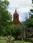 | |
| 9/2/242/0002 | Fort Merensky, Botshabelo, Middelburg District | Fort Merensky stands on a prominent hill in a commanding position near Botshabelo, a former Berlin mission station, 13 kilo- metres from Middelburg on the road to Groblersdal.
By 1860 the Berlin Missionary Society had established mission stations in the C Fort Merensky stands on a prominent hill in a commanding position near Botshabelo, a former Berlin mission station, 13 kilo- metres from Middelburg on the road to Groblersdal. By 1860 the Berlin Missionary Society had established mission stations in the C. Fort Merensky, originally called Fort Wilhelm, was built by the missionary Alexander Merensky and his followers at the Mission Station which he established there in 1865. |
Middelburg | Provincial Heritage Site | 25°41′51″S 29°24′40″E / 25.697575°S 29.411012°E | 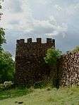 | |
| 9/2/242/0003 | Mapoch's Caves, Roos Senekal, Middelburg District | Middelburg | Provincial Heritage Site | 25°13′13″S 29°56′21″E / 25.220228°S 29.939268°EMapoch's Caves, Roos Senekal, Middelburg District) |
| ||
| 9/2/242/0010 | Meyer Bridge, Little Olifants River, Middelburg | The Meyer Bridge across the Little Olifants River is about one kilometre outside the town of Middelburg, Transvaal, on the road to Stoffberg and Roossenekal.
The bridge was built under Act No. 698, passed on 16 October 1895, by the Executive Council. T Type of site: Bridge. Meyer's Bridge is one of the fine stone bridges built by the South African Republic. It was built in 1896. |
Middelburg | Middelburg | Provincial Heritage Site | 25°45′40″S 29°28′25″E / 25.761153°S 29.473478°E |
|
| 9/2/242/0011 | Dutch Reformed Gedenkkerk, South Street, Middelburg | This little church was erected shortly after the Anglo- Boer War (1899-1902) in commemoration of the 1400 women and children who died in the local concentration camp. Type of site: Church. This little church was erected shortly after the Anglo- Boer War (1899-1902) in commemoration of the 1400 women and children who died in the local concentration camp. | Middelburg | Middelburg | Provincial Heritage Site | 25°45′44″S 29°27′25″E / 25.762256°S 29.456953°E |  |
| 9/2/242/0015 | NZASM Station, Meyer and Van Riebeeck Streets, Middelburg | This railway station is an important feature of the railway line from Pretoria to Delagoa Bay, which was constructed between 1890 and 1894 by the well-known
"Nederlandsche Zuid-Afrikaansche Spoorwegmaatschappij". The station was probably built in 1894 and Type of site: Station Building. |
Middelburg | Middelburg | Provincial Heritage Site | 25°46′26″S 29°28′12″E / 25.773822°S 29.470081°E |  |
| 9/2/248/0002 | NZASM Station, Elandshoek, Nelspruit District | Type of site: Railway Station. | Nelspruit | Provincial Heritage Site | 25°30′15″S 30°42′02″E / 25.504170°S 30.700560°E |
| |
| 9/2/248/zz | Lime kilns, Grootgeluk 477, Nelspruit District | These kilns were erected at the turn of the century to slake the very pure limestone derived from the nearby limestone mine. At one stage they supplied the whole Barberton District with lime and thus played an important role in the reclamation of gold in Type of site: Industrial. | Nelspruit | Provincial Heritage Site | 25°35′14″S 30°38′39″E / 25.587263°S 30.644212°E | 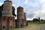 | |
| 9/2/254/0001 | Dutch Reformed Church, Church Street, Piet Retief | Type of site: Church. | Piet Retief | Piet Retief | Register | 27°00′10″S 30°48′06″E / 27.002788°S 30.801630°E | 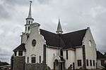 |
| 9/2/255/0002 | Huntington Hall, Sabie | Sabie | Pilgrim's Rest | Provincial Heritage Site | 25°05′47″S 30°46′30″E / 25.096351°S 30.774939°E |
| |
| 9/2/255/0006 | Mac Mac Waterfalls, Geelhoutboom, Pilgrim's Rest District | These waterfalls, which drop 65 m in two uninterrupted cascades, as well as the indigenous forest in the kloof below the falls, form an integral part of the natural beauty of the Eastern Transvaal escarpment. Type of site: Waterfall. These waterfalls, which drop 65 m in two uninterrupted cascades, as well as the indigenous forest in the kloof below the falls, form an integral part of the natural beauty of the Eastern Transvaal escarpment. | Pilgrim's Rest | Provincial Heritage Site | 25°00′03″S 30°49′02″E / 25.000754°S 30.817192°E | 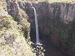 | |
| 9/2/255/0007 | Natural rock bridge, Graskop 564 KT, Pilgrim's Rest District | The Natural rock bridge is a unique geological feature. Type of site: Bridge. | Pilgrim's Rest | Provincial Heritage Site | 24°55′32″S 30°49′49″E / 24.925620°S 30.830209°E |
| |
| 9/2/255/0008 | Lone Creek Waterfall, Ceylon 197, Pilgrim's Rest District | Type of site: Waterfall. These exceptionally attractive waterfalls, which drop 68 m in a single cascade, as well as the indigenous forest in the kloof below the falls, form an integral part of the natural beauty of the Eastern Transvaal escarpment. | Pilgrim's Rest | Provincial Heritage Site | 25°06′08″S 30°42′34″E / 25.102266°S 30.709324°E | 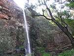 | |
| 9/2/255/0016 | Berlin Waterfall, Berlyn 506, Pilgrim's Rest District | Type of site: Waterfall. These attractive waterfalls, which have a drop of 45 metres, as well as their surroundings, form an integral part of the natural beauty of the Eastern Transvaal escarpment. | Pilgrim's Rest | Provincial Heritage Site | 24°50′37″S 30°50′33″E / 24.843724°S 30.842607°E | 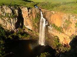 | |
| 9/2/255/0017 | Joubert Bridge, Blyde River, Pilgrim's Rest District | This bridge across the Blyde River is situated about three kilometres from Pilgrim’s Rest on the road to Lydenburg and the Blyde River Poort.
The bridge was built under Act No. 201, passed by the Executive Council on 11 March 1896. The contractor was G Type of site: Bridge. |
Pilgrim's Rest | Provincial Heritage Site | 24°53′55″S 30°45′02″E / 24.89858°S 30.75045°E |  | |
| 9/2/278/0001 | Old NZASM Station Building and Old Customs House, Sarel Cilliers Street, Volksrust | Type of site: Station Building, Customs House. | Volksrust | Volksrust | Provincial Heritage Site | 27°22′20″S 29°53′24″E / 27.372260°S 29.889945°E |
|
| 9/2/278/0008 | Grave of Gen Piet Joubert, Rustfontein 126, Volksrust District | General Piet Joubert, one-time Commandant-General of the South African Republic, and his wife are buried in this graveyard in an architecturally impressive mausoleum. Type of site: Grave. General Piet Joubert was Commandant-General of the South African Republic and his wife are buried in | Volksrust | Provincial Heritage Site | 27°20′53″S 29°36′41″E / 27.347986°S 29.611282°E |
| |
| 9/2/279/0006 | Old Road Bridge, Marthinus Wesselstroom, Wakkerstroom | This bridge was designed b the Zuid-Afrikaansche Republiek’s Department of Public Works and erected by A. Klute. It as completed in 1893 and ‘sas one of the last steel bridges commissioned by the government of the ZAR. Furthermore, on 24 May 1904 D. Bryan Type of site: Bridge. | Wakkerstroom | Wakkerstroom | Provincial Heritage Site | 27°20′43″S 30°08′31″E / 27.345221°S 30.141842°E |
|
| 9/2/279/0006-001 | Old Apostolic Church of Africa, Church Street, Wakkerstroom | This well-preserved former Anglican Church, previously known as St Mark's Church, was consecrated on 6 April 1890 by the Bishop of Pretoria, the Right Revd. H. B. Bousfield. It is built of laterite. A fine stained glass window was installed in about 1959. Type of site: Church. This well-preserved former Anglican Church, previously known as St Mark's Church, was consecrated on 6 April 1890 by the Bishop of Pretoria, the Right Revd. H. B. Bousfield. It is built of laterite. A fine stained glass window was installed in about 1959 | Wakkerstroom | Wakkerstroom | Provincial Heritage Site | 27°21′16″S 30°08′32″E / 27.354313°S 30.142327°E |
|
| 9/2/282/0001 | Five Arched Bridge, Doornhoek, Waterval Boven District | The bridge is a particularly fine stone structure and was originally built for the Z.A.S.M. railway line between Pretoria and Maputo. The construction of the tunnel was not the only problem encountered in building the difficult section of the railway between Waterval Onder and Waterval Boven. Not far below the tunnel, the line had to cross the Dwaalheuwel Spruit. The N.Z.A.S.M. built a Type of site: Bridge. The construction of the tunnel was not the only problem encountered in building the difficult section of the railway between Waterval Onder and Waterval Boven. Not far below the tunnel, the line had to cross the Dwaalheuwel Spruit. The N.Z.A.S.M. built a | Waterval Boven | Provincial Heritage Site | 25°38′40″S 30°21′15″E / 25.644444°S 30.354167°E |
| |
| 9/2/282/0002 | NZASM Tunnel, Doornhoek, Waterval Boven District | Beyond Waterval Boven the road winds down the steep slopes of the Elandsberg for eight km to Waterval Onder. This short length of road not only provides magnificent scenery, but takes the traveller through a region full of historical interest. Overlooking In order to make the Zuid-Afrikaansche Republiek economically independent of the surrounding British Colonies, Paul Kruger did his best to promote a direct railway connection between the Portuguese harbour of Lourenço Marques and Pretoria. Consequently th Type of site: Tunnel. The tunnel was part of the N.Z.A.S.M. railway line built in 1891-1895 between Pretoria and Lourenco Marques. In view of the steep gradient it was fitted with a rack railway. | Waterval Boven | Provincial Heritage Site | 25°38′04″S 30°20′41″E / 25.634400°S 30.344619°E |  | |
| 9/2/282/0005 | Krugerhof, Waterval Onder, Waterval Boven District | Small cottage with wooden verandah all round. All rooms lead off verandah, no internal doors. Picturesque garden set in darmatic sceneray The old house known as Krugerhof stands in front of the hotel at Waterval Onder.
In May, 1900, strong British forces under command of Lord Roberts approached Pretoria and the Government of the Zuid-Afrikaansche Republiek was forced to move its headquarters. Type of site: House Previous use: Hire rooms. Current use: Museum. Access: The main access route is via the N4 Nelspruit/Pretoria main road. The property is accessed via asmall tarred road turn off from the N4. The last residence of Paul Kruger before he left SA for Mozambique and Europe. President S J. P. Kruger lived in this house from 30 June to 28 August 1900. During that time the affairs of State of the South, African: Republic were conducted the |
Waterval Boven, Doornhoek | Waterval Boven | Provincial Heritage Site | 25°38′49″S 30°23′04″E / 25.6469527777°S 30.384392°E |  |
| 9/2/282/0008 | Blaauboschkraal stone ruins | Waterval Boven | Provincial Heritage Site | 25°35′41″S 30°17′20″E / 25.594667°S 30.288776°EBlaauboschkraal stone ruins) |
| ||
| 9/2/284/0001 | NZASM Station, Clewer, Schoongezicht 308 JS, Witbank District | Type of site: Railway station Current use: Railway station. | Witbank | Provincial Heritage Site | 25°53′57″S 29°08′17″E / 25.899286°S 29.138056°E |
| |
| BelfastTemp | Naval Gun Barrel, High School Belfast, Duggen Street, Belfast | During the British occupation of Port Natal in 1842 under the leadership of Captain T. C. Smith and the subsequent skirmtish with a Voortrekker commando under General A. W. J. Pretorius, one Bezuidenhout captured this naval gun barrel from the British. It Type of site: Gun. | Belfast | Belfast | Heritage Object |
|
References
| Wikimedia Commons has media related to Cultural heritage monuments in Mpumalanga. |
Lists of South African Heritage Resources | ||||||||||||||||||||||||||||||||||||
|---|---|---|---|---|---|---|---|---|---|---|---|---|---|---|---|---|---|---|---|---|---|---|---|---|---|---|---|---|---|---|---|---|---|---|---|---|
| SAHRA Heritage sites |
| |||||||||||||||||||||||||||||||||||
| World heritage sites | ||||||||||||||||||||||||||||||||||||