List of heritage sites in Clanwilliam
This is a list of the heritage sites in Clanwilliam, Western Cape as recognized by the South African Heritage Resources Agency.[1]
| SAHRA identifier | Site name | Description | Town | District | NHRA status | Coordinates | Image |
|---|---|---|---|---|---|---|---|
| 9/2/022/0001 | Boontjieskloof Farm Clanwilliam District | Clanwilliam | Clanwilliam | 
| |||
| 9/2/022/0002 | CLANWILLIAM MUNICIPAL AREA, GENERAL | Clanwilliam | Clanwilliam | 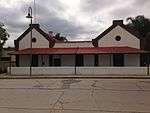 | |||
| 9/2/022/0003 | Caleta Cove, Clanwilliam | Clanwilliam | Clanwilliam |
| |||
| 9/2/022/0004 | British Graves, Lamberts Bay, Clanwilliam | Lamberts Bay | Clanwilliam |
| |||
| 9/2/022/0005 | Clanwilliam Museum, Main Street, Clanwilliam | Symmetrical stone building with three-bayed central pavilion.
Plaster decorations at windows and corners.
Round headed openings.
Left hand side has addition constructed c. 1890.
Parapets with moulded cornices conceal low-pitched roof.
This Georgian building, the core of which was probably erected as early as 1808, is a prominent architectural feature in the historic core of Clanwilliam.
|
Clanwilliam | Clanwilliam | Provincial Heritage Site | 32°10′33″S 18°53′34″E / 32.175930°S 18.892660°E | 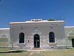 |
| 9/2/022/0006 | Dovecote and Anglo-Boer War blockhouse, Graafwater Farm, Clanwilliam District | Type of site: Dovecote, Blockhouse | Clanwilliam | Provincial Heritage Site | 32°09′05″S 18°35′35″E / 32.151389°S 18.593056°E |
| |
| 9/2/022/0006-001 | Dovecote, Graafwater Farm, Clanwilliam District | Type of site: Dovecote | Clanwilliam | Provincial Heritage Site | 32°08′44″S 18°36′50″E / 32.145437°S 18.613820°E |
| |
| 9/2/022/0006-002 | Anglo-Boer War blockhouse, Graafwater Farm, Clanwilliam District | Type of site: Blockhouse | Clanwilliam | Provincial Heritage Site | 32°08′44″S 18°36′50″E / 32.145451°S 18.613989°E |
| |
| 9/2/022/0007 | Sandveld cottage, Thee Rivier, Clanwilliam District (Pending N M) | Clanwilliam | Clanwilliam |
| |||
| 9/2/022/0008 | Cederberg Wilderness Area, Clanwilliam District | Clanwilliam | Clanwilliam | 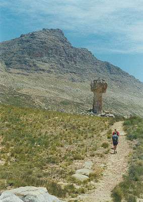 | |||
| 9/2/022/0009 | Steenbokfontein, Clanwilliam District | Clanwilliam | Clanwilliam | 32°10′05″S 18°18′53″E / 32.167939°S 18.314681°E |
| ||
| 9/2/022/0010 | St John's Anglican Church, Main Street, Clanwilliam | Rectangular stone building with steep slate roof and a straight-sided gable at its front end.
The choir behind, following the same form, is an 1876 addition.
The building known as "St John the Evangelist" is probably the most unaltered example of the work of Sophia Gray, the wife of Bishop Robert Gray, first Anglican Bishop of Cape Town.
Since the arrival of the Grays in the Cape in 1843, Sophia Grey was respo
|
Clanwilliam | Clanwilliam | Provincial Heritage Site | 32°10′44″S 18°53′35″E / 32.178808°S 18.893169°E | 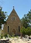 |
| 9/2/022/0010/1 | Graves, St John's Anglican Church, Main Street, Clanwilliam | Clanwilliam | Clanwilliam | 32°10′33″S 18°53′34″E / 32.175930°S 18.892660°E |
| ||
| 9/2/022/0011 | Irish Settlers house, off Main Street, Clanwilliam | Simple rectangular vernacular plastered building with thatched half-hipped roof.
Small square windows.
Some alterations.
This Settler cottage dates from the early nineteenth century and represents the vernacular building style used by the Irish Settlers of the eighteen-twenties.
|
Clanwilliam | Clanwilliam | Provincial Heritage Site | 32°10′33″S 18°53′34″E / 32.175930°S 18.892660°E |
|
| 9/2/022/0012 | Anglican Rectory, 37 Main Street, Clanwilliam | Thatched roofed building with white plastered walls.
Front and back facades with dormer gables and good Georgian doors and windows are almost identical.
The parsonage probably dates from the 1840s and is similar to the rectory in Bredasdorp.
It has a very unusual plan, being square with only a narrow opening giving access to the central courtyard.
The front and back facades, with dormer gables and Georg
|
Clanwilliam | Clanwilliam | Provincial Heritage Site | 32°10′47″S 18°53′38″E / 32.179732°S 18.893782°E | 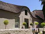 |
| 9/2/022/0013 | Old Dutch Reformed Church, Main Street, Clanwilliam | Very fine Cape Gothic church, rectangular in plan with small Gothic tower to street elevation.
Also fine Gothic entrance gate.
Now painted white, previously colour-washed with details picked out.
This church building was designed in the neo-Gothic style by Carl Otto Hager, the well-known architect.
Hager also supervised its erection, which was completed about 1864.
|
Clanwilliam | Clanwilliam | Provincial Heritage Site | 32°10′49″S 18°53′37″E / 32.180389°S 18.893553°E | 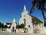 |
| 9/2/022/0013/001 | Old Dutch Reformed Memorial Hall, Main Street, Clanwilliam | Type of site: Church This memorial hall falls within a proposed conservation area and forms part of an historical core of the town together with the old gaol, the Dutch Reformed Church, the Anglican Parsonage and the declared Park Street properties.
Having been restored to i |
Clanwilliam | Clanwilliam | Register | 32°10′49″S 18°53′37″E / 32.180389°S 18.893553°E |
|
| 9/2/022/0014 | Orange tree, Hexrivier, Clanwilliam District | Type of site: Tree | Clanwilliam | Provincial Heritage Site | 32°26′25″S 18°58′23″E / 32.440148°S 18.972938°E |
| |
| 9/2/022/0015 | 2 Park Street, Clanwilliam | This building was erected in the eighteen-twenties as a dwelling for the Deputy Landdrost.
It is in the Cape Dutch style and TT -shaped.
The building is one of the oldest dwellings in Clanwilliam.
|
Clanwilliam | Clanwilliam | Provincial Heritage Site | 32°10′51″S 18°53′40″E / 32.180971°S 18.894469°E | 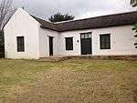 |
| 9/2/022/0016 | Die Erf, 5 Park Street, Clanwilliam | his house in the Cape Dutch style housed one of the Drostdy officials shortly after the establishment of a sub-drostdy at Clanwilliam in 1808.
|
Clanwilliam | Clanwilliam | Provincial Heritage Site | 32°10′53″S 18°53′42″E / 32.181260°S 18.894922°E | 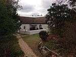 |
| 9/2/022/0017 | Anglo-Boer War blockhouse, Cederberg, Clanwilliam District (Pending N M) | Clanwilliam | Clanwilliam |
| |||
| 9/2/022/0018 | Kromme Rivier, Clanwilliam District | Clanwilliam | Clanwilliam |
| |||
| 9/2/022/0019 | WUPPERTHAL, CLANWILLIAM DISTRICT, GENERAL | Wupperthal | Clanwilliam |
| |||
| 9/2/022/0020 | Longkloof, Clanwilliam District | Clanwilliam | Clanwilliam |
| |||
| 9/2/022/0021 | Grave of Lt Clowes, Pakhuis Pass, Clanwilliam District | Clanwilliam | Clanwilliam |
| |||
| 9/2/022/0022 | Doorspring, Clanwilliam District | Clanwilliam | Clanwilliam | 32°00′18″S 18°18′21″E / 32.005035°S 18.305856°E |
| ||
| 9/2/022/0023 | C. Louis Leipoldt rock shelter, Pakhuis Pass, Clanwilliam District | Clanwilliam | Clanwilliam |
| |||
| 9/2/022/0024 | CLANWILLIAM MAGISTERIAL DISTRICT GENERAL | Clanwilliam | Clanwilliam |  | |||
| 9/2/022/0024/01 | Archaeological Site, Clanwilliam District. | Clanwilliam | Clanwilliam |
| |||
| 9/2/022/0025 | Old Residency, 3 Park Street, Clanwilliam | Type of site: Residency
|
Clanwilliam | Clanwilliam | Provincial Heritage Site | 32°10′52″S 18°53′40″E / 32.181018°S 18.894554°E |
|
| 9/2/022/0026 | Mission Station, Wupperthal, Clanwilliam District (Conservation area) | Wupperthal | Clanwilliam | 32°14′19″S 19°11′44″E / 32.238519°S 19.195682°EWupperthal, Clanwilliam District (Conservation area)) | 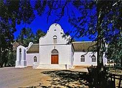 | ||
| 9/2/022/0027 | Matjiesrivier Farm, Clanwilliam District | Clanwilliam | Clanwilliam |
| |||
| 9/2/022/0028 | Lorraine, Clanwilliam District | Clanwilliam | Clanwilliam |
| |||
| 9/2/022/0029 | LAMBERTS BAY MUNICIPAL AREA, GENERAL | Lamberts Bay | Clanwilliam |
| |||
| 9/2/022/0031 | Kriedouwkrans Rock Paintings, Clanwilliam District | Clanwilliam | Clanwilliam |
| |||
| 9/2/022/0032 | Rock Art Sites in Oliphants River Valley, Clanwilliam Dist | Clanwilliam | Clanwilliam | 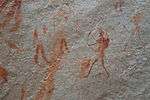 | |||
| 9/2/022/0033 | Rock Shelters, Kleinfontein Farm, Clanwilliam Dist | Clanwilliam | Clanwilliam |
| |||
| 9/2/022/0034 | Military Graves, Farm Bodam, Clanwilliam District (War graves) | Clanwilliam | Clanwilliam |
| |||
| 9/2/022/0035 | SEDERVILLE LOCAL AREA, GENERAL, CLANWILLIAM DISTRICT | Clanwilliam | Clanwilliam |
| |||
| 9/2/022/0036 | CITRUSDAL MUNICIPAL AREA GENERAL | Clanwilliam | Clanwilliam |
| |||
| 9/2/022/0037 | Heerenlogement, Graafwater, Clanwilliam District | Clanwilliam | Clanwilliam | Provincial Heritage Site | 31°57′42″S 18°32′59″E / 31.961755°S 18.549668°E |
| |
| 9/2/022/0038 | The Baths, Farm no 496, Citrusdal, Clanwilliam District | Citrusdal | Clanwilliam | 32°35′06″S 19°00′41″E / 32.585099°S 19.011325°E |
| ||
| 9/2/022/0051 | Nortier Reserve, Clanwilliam | Clanwilliam | Deproclaimed | 32°10′44″S 18°53′20″E / 32.178793°S 18.888797°E |
| ||
| 9/9/022/0030 | De Hangen Rock Shelter, Nardouwsberg, Clanilliam District | Clanwilliam |
|
References
- ↑ South African Heritage Resource Agency SARHA - Gazetted Sites database, Accessed on 8 October 2012
| Wikimedia Commons has media related to Cultural heritage monuments in Clanwilliam, Western Cape. |
Lists of South African Heritage Resources | ||||||||||||||||||||||||||||||||||||
|---|---|---|---|---|---|---|---|---|---|---|---|---|---|---|---|---|---|---|---|---|---|---|---|---|---|---|---|---|---|---|---|---|---|---|---|---|
| SAHRA Heritage sites |
| |||||||||||||||||||||||||||||||||||
| World heritage sites | ||||||||||||||||||||||||||||||||||||