List of heritage sites in Stellenbosch, Somerset West, and Strand
This is a list of heritage sites in Stellenbosch, Somerset West, and Strand, situated in the Western Cape, as recognized by the South African Heritage Resource Agency.[1]
Heritage sites in Stellenbosch town
| SAHRA identifier | Site name | Description | Town | District | NHRA status | Coordinates | Image |
|---|---|---|---|---|---|---|---|
| 9/2/084/0001 | STELLENBOSCH MUNICIPAL AREA, GENERAL | Stellenbosch | Stellenbosch |  | |||
| 9/2/084/0001-026 | Oak trees, Dorp Street and The Avenue, Stellenbosch | Dorp Street is the old wagon road to Cape Town and, just like three centuries ago, visitors still enter the town along the same road. Thus the old street rightly serves as an introduction to the Town of Oaks, for on both sides of the street one sees the beautiful, shady and gnarled old oak trees of which the biggest old giants probably date back to 1760. The age of the others dates back to the year 1812. The increase in modern traffic which makes the widening of the streets essential, has threatened the life of these trees, but with the cordial co-operation of the Municipality the trees in Dorp Street, between the railway line and Pastorie Street and those in the Avenue between Pastorie and Van Riebeeck Streets, have been proclaimed historical monuments. However, a new danger—leaf-blight—now threatens these ancient trees. Proclaimed 1950. | Stellenbosch | Stellenbosch | Provincial Heritage Site | 33°55′56″S 18°51′37″E / 33.932105°S 18.860152°E | |
| 9/2/084/0001-027 | Oak trees, Parsonage Street, Church Street, Drostdy Street, Ryneveld Street, Andringa Street, Bird Street, Plein Street and Van Riebeeck Street, Stellenbosch | In 1968 the oak trees in the following streets were also proclaimed historical monuments: Pastorie, Church, Drostdy, Ryneveld, Crozier, Andringa, Bird and Van Riebeeck Streets. | Stellenbosch | Stellenbosch | Provincial Heritage Site | 33°56′16″S 18°51′44″E / 33.937886°S 18.862112°E | .jpg) |
| 9/2/084/0002/03 | Ida Minor, Idas Valley, Stellebosch District | Stellenbosch | Stellenbosch | National Monument | 
| ||
| 9/2/084/0002/18 | Wedgewood Farm, Idas Valley, Stellebosch District | Stellenbosch | Stellenbosch | National Monument |
| ||
| 9/2/084/0003 | Devonshire House, 13 Ryneveld Street, Stellenbosch | The Devonshire House is situated on the oldest street corner of Stellenbosch and was erected here in about 1861. It is a double-storeyed townhouse in the early Victorian style. | Stellenbosch | Stellenbosch | Provincial Heritage Site | 33°56′16″S 18°51′46″E / 33.937676°S 18.862676°E | 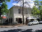 |
| 9/2/084/0004 | Oude Leeskamer, 182 Dorp Street, Stellenbosch | This building was originally used by the College of Landdrost and Heemraden as offices. The foundation meeting for the educational institution which was to become known as the Gymnasium, was held here in 1863. Before the completion of the Gymnasium building in 1866, the Oude Leeskamer was used as a school building for three months. | Stellenbosch | Stellenbosch | Provincial Heritage Site | 33°56′18″S 18°51′49″E / 33.938426°S 18.863597°E | 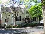 |
| 9/2/084/0005 | Mostertsdrift, Jonkershoek Road, Stellenbosch | Mostertsdrift, the ancestral farm of the Mostert family in South Africa, is also one of those farms which is really older than the town itself. Johannes (Jan) Cornelisz Mostert together with his wife, Alida van Hulst, came to the Cape about 1672. Shortly before Simon van der Stel’s arrival, permission was given to Mostert and Pieter Visagie to cultivate the farm Buffelscop to the east of the Tygerberg. But, Buffelscop was a loan-farm and when Simon van der Stel announced in November 1679 that freehold land was available to all who wished to settle along the banks of the Eerste River, Jan Mostert availed himself of the offer. He chose the beautiful piece of land on the north bank of the Eerste River where the present residential area, Mostertsdrift, is situated. The homestead of Mostertsdrift, situated among shady oak-trees and surrounded by a high wall, is not only part of the early history of the Town of Oaks, but also an elegant example of an old-fashioned, aristocratic group of farm-buildings in the Boland. | Stellenbosch | Stellenbosch | Provincial Heritage Site | 33°56′05″S 18°52′53″E / 33.934683°S 18.881480°E | 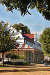 |
| 9/2/084/0007 | Kromme Rhee, Koelenhof, Stellenbosch District | Stellenbosch | Stellenbosch | National Monument | 33°52′21″S 18°49′36″E / 33.872520°S 18.826700°E |
| |
| 9/2/084/0009 | Stellenbosch Museum, 18 Ryneveld Street, Stellenbosch | Stellenbosch | Stellenbosch | National Monument | 33°56′07″S 18°51′44″E / 33.935410°S 18.862160°E |
| |
| 9/2/084/0010 | Jannie Marais House, Coetzenburg, Noordwal East, Stellenbosch | The site with the historic old Coetzenburg farmstead (now known as the Stellenbosch Jannie Marais House), the cellar and outbuildings thereon, together with that portion of land north of the house and extending to the banks of the Eerste River. | Stellenbosch | Stellenbosch | Provincial Heritage Site | 33°56′17″S 18°52′12″E / 33.938148°S 18.869973°E | 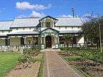 |
| 9/2/084/0011 | Die Laan, Stellenbosch | Stellenbosch | Stellenbosch | National Monument | 33°56′19″S 18°52′00″E / 33.938617°S 18.866761°E | .JPG) | |
| 9/2/084/0011/002 | 24 The Avenue, Stellenbosch | The property, together with the Georgian dwelling thereon. | Stellenbosch | Stellenbosch | Provincial Heritage Site | 33°55′56″S 18°51′37″E / 33.932105°S 18.860152°E | .JPG) |
| 9/2/084/0011/004 | Moedersloon, 8 The Avenue, Stellenbosch | Stellenbosch | Stellenbosch | Provincial Heritage Site | 33°55′03″S 18°50′40″E / 33.917586°S 18.844440°E | .JPG) | |
| 9/2/084/0011/1 | 6 Die Laan, Stellenbosch | Stellenbosch | Stellenbosch | 33°56′19″S 18°51′55″E / 33.938502°S 18.865298°E |
| ||
| 9/2/084/0011/3 | 22 Die Laan, Stellenbosch | Stellenbosch | Stellenbosch | Pending Declaration | 33°56′18″S 18°52′03″E / 33.938254°S 18.867436°E |
| |
| 9/2/084/0011/5 | 20 Die Laan, Stellenbosch | Stellenbosch | Stellenbosch | National Monument | 33°56′18″S 18°52′02″E / 33.938272°S 18.867286°E |
| |
| 9/2/084/0012 | Officers' Mess, 15 Market Street, Stellenbosch | This interesting architectural complex of houses, which dates mainly from the 19th century, forms an integral part of the entire western side of Market Street, as well as of the historic core of Stellenbosch itself. | Stellenbosch | Stellenbosch | Provincial Heritage Site | 33°56′19″S 18°51′18″E / 33.938580°S 18.854910°E |  |
| 9/2/084/0013 | Homestead, Jonkershoek, Stellenbosch District | Stellenbosch | Stellenbosch | National Monument |
| ||
| 9/2/084/0014 | Mill stream, Stellenbosch | That portion of the mill stream that stretches from Erf 1629 in Mostertsdrift in a north-westerly direction up to Marais Street; thence in a westerly direction in Van Riebeeck Street up to Andringa Street; thence in a south-westerly direction up to the eastern boundary of Erf 6460 and thence in a north-westerly direction up to the intersection of Skone Uitsig and Alexander Streets. | Stellenbosch | Stellenbosch | Provincial Heritage Site | 33°56′14″S 18°52′13″E / 33.937145°S 18.870370°E |  |
| 9/2/084/0015 | Proteahof, 80–120 Ryneveld Street, Stellenbosch | This building complex, which was erected shortly after 1860, originally formed part of a housing scheme for former slaves. The cottages have been restored. | Stellenbosch | Stellenbosch | Provincial Heritage Site | 33°55′45″S 18°51′42″E / 33.929300°S 18.861732°E |  |
| 9/2/084/0016 | Historical Trees in Stellenbosch | Stellenbosch | Stellenbosch | National Monument |
| ||
| 9/2/084/0017 | 1 Herold Street, Stellenbosch | Stellenbosch | Stellenbosch | 33°56′24″S 18°51′09″E / 33.939963°S 18.852531°E |
| ||
| 9/2/084/0018 | Zevenrivieren, Banhoek, Stellenbosch District | Stellenbosch | Stellenbosch |
| |||
| 9/2/084/0019 | Stellenbosch Hotel, 160 Dorp Street, Stellenbosch | Stellenbosch | Stellenbosch | Provincial Heritage Site | 33°56′19″S 18°51′45″E / 33.9385833333°S 18.8626333333°E |  | |
| 9/2/084/0021 | Coachman's Cottage, 40 Alexander Street, Stellenbosch | Across the road from the Burgher House, next to the Divisional Council Offices, stands this charming thatched cottage, with its dormer window in front and attractive concavo-convex side gables. | Stellenbosch | Stellenbosch | Provincial Heritage Site | 33°56′10″S 18°51′19″E / 33.936078°S 18.855171°E |  |
| 9/2/084/0022 | Leef op Hoop/Klein Gustrouw, Jonkershoek, Stellenbosch District | Stellenbosch | Stellenbosch | National Monument |
| ||
| 9/2/084/0023 | Lanzerac, Jonkershoek, Stellenbosch | Granted to Isaac Schryver in 1692. In 1806 the farm passed to Coenraad Johannes Fick who probably built Lanzerac around 1830 in the Cape Dutch style. | Stellenbosch | Stellenbosch | Provincial Heritage Site | 33°56′16″S 18°53′39″E / 33.937766°S 18.894109°E |  |
| 9/2/084/0024 | Rhenish Mission Church, Blom Street, Stellenbosch | The lovely old Rhenish Mission Church with its fine gables, built in the form of an incomplete T, faces the southern side of the Braak. This is one of the oldest mission churches in South Africa. The delicate architectural treatment which betrays strong Renaissance influence, is typical of early 19th-century architecture. The gable, which bears the date of its erection, 1823, is one of the finest of its kind. In 1840 the northern wing was built. | Stellenbosch | Stellenbosch | Provincial Heritage Site | 33°56′17″S 18°51′32″E / 33.937932°S 18.858960°E |  |
| 9/2/084/0024/001 | Pulpit, Rhenish Mission Church, Blom Street, Stellenbosch | The Rhenish Church facing the Braak is not only known for its history and its architectural qualities, but also for the fine pulpit inside it. The pulpit and lectern were made by Simon Pieter Christoffel Londt in 1853. | Stellenbosch | Stellenbosch | Heritage Object |
| |
| 9/2/084/0024/1 | Pulpit, Rhenish Church, The Braak, Stellenbosch | Stellenbosch | Stellenbosch | National Monument | 33°56′16″S 18°51′32″E / 33.937915°S 18.858939°E |
| |
| 9/2/084/0027 | Schreuder House, 10 Ryneveld Street, Stellenbosch | This colonial house was built in 1709 by Sebastian Schreuder and is the oldest known existent dwelling in South Africa. | Stellenbosch | Stellenbosch | Provincial Heritage Site | 33°56′16″S 18°51′47″E / 33.937642°S 18.862954°E |  |
| 9/2/084/0028 | 17 Van Riebeeck Street, Stellenbosch | Stellenbosch | Stellenbosch | National Monument | 33°56′13″S 18°51′59″E / 33.936842°S 18.866390°E |
| |
| 9/2/084/0029 | Gujjatul Islam Jamaah Mosque, Banhoek Road, Stellenbosch | Stellenbosch | Stellenbosch | 33°55′50″S 18°51′33″E / 33.930598°S 18.859172°E |
| ||
| 9/2/084/0030 | Bergzicht Market Square, Stellenbosch | Stellenbosch | Stellenbosch |
| |||
| 9/2/084/0031 | 99 Dorp Street, Stellenbosch | Stellenbosch | Stellenbosch | 33°56′22″S 18°51′30″E / 33.939360°S 18.858260°E |
| ||
| 9/2/084/0034 | 21 Van Riebeeck Street, Stellenbosch | Stellenbosch | Stellenbosch | National Monument | 33°56′13″S 18°52′01″E / 33.937004°S 18.867003°E |
| |
| 9/2/084/0035 | Army Club, 15 Market Street, Stellenbosch | Stellenbosch | Stellenbosch | 33°56′20″S 18°51′17″E / 33.938896°S 18.854645°E |
| ||
| 9/2/084/0036 | Annandale Farm, Stellenbosch | Stellenbosch | Stellenbosch | National Monument | 33°59′49″S 18°49′51″E / 33.997071°S 18.830780°E |
| |
| 9/2/084/0037 | 19 Riebeeck Street, Stellenbosch | Stellenbosch | Stellenbosch | 33°56′13″S 18°52′00″E / 33.936897°S 18.866734°E |
| ||
| 9/2/084/0038 | 137 Dorp Street, Stellenbosch | Stellenbosch | Stellenbosch | 33°56′20″S 18°51′38″E / 33.939026°S 18.860650°E |
| ||
| 9/2/084/0039 | Fynbos Guesthouse, 14 Neethling Street, Stellenbosch | Stellenbosch | Stellenbosch | Register | 33°56′14″S 18°52′00″E / 33.937207°S 18.866592°E | .JPG) | |
| 9/2/084/0040 | 17 Market Street, Stellenbosch | Stellenbosch | Stellenbosch | Register | 33°56′21″S 18°51′16″E / 33.939140°S 18.854331°E |
| |
| 9/2/084/0042 | 34 Church Street, Stellenbosch | Stellenbosch | Stellenbosch | 33°56′16″S 18°51′44″E / 33.937888°S 18.862086°E |
| ||
| 9/2/084/0043 | 36 Church Street, Stellenbosch | Stellenbosch | Stellenbosch | 33°56′16″S 18°51′44″E / 33.937873°S 18.862226°E |
| ||
| 9/2/084/0044 | Kromme Rivier, Paul Kruger Street, Stellenbosch | Stellenbosch | Stellenbosch | 33°55′40″S 18°51′24″E / 33.927719°S 18.856642°E |  | ||
| 9/2/084/0044-001 | Kromme Rivier (Barn), Hofman Street, Stellenbosch | The building described as the Krommerivier Barn is situated at the corner of Hofman and Kruger Streets. This barn is a reconstruction, to its 1850s appearance, of one of the oldest surviving buildings in Stellenbosch: a rare long outbuilding dating from the 1730s. The barn has been used as a coachhouse and stables, storage area and human habitation. | Stellenbosch | Stellenbosch | Register | 33°55′52″S 18°51′21″E / 33.931045°S 18.855882°E | |
| 9/2/084/0045 | Voet van Helderberg, Stellenbosch | Stellenbosch | Stellenbosch | Pending Declaration | 34°02′09″S 18°51′41″E / 34.035820°S 18.861434°E |
| |
| 9/2/084/0046 | 176 Dorp Street, Stellenbosch | This typical town house with slave quarters originally dates from the 18th century. The building was altered to its present form in 1813 when it became the residence of the Secretary to the College of Landdrost and Heemraden. | Stellenbosch | Stellenbosch | Provincial Heritage Site | 33°56′18″S 18°51′48″E / 33.938288°S 18.863297°E | 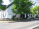 |
| 9/2/084/0047 | Bergzicht Farmstead, Stellenbosch | Stellenbosch | Stellenbosch | National Monument |
| ||
| 9/2/084/0048 | 3 Ryneveld Street, Stellenbosch | Stellenbosch | Stellenbosch | Provincial Heritage Site | 33°56′17″S 18°51′47″E / 33.938044°S 18.863027°E | .JPG) | |
| 9/2/084/0049 | Zorgvliet West, Stellenbosch | Stellenbosch | Stellenbosch | National Monument | 33°54′53″S 18°56′08″E / 33.914589°S 18.935571°E |
| |
| 9/2/084/0050 | Bletterman House, Plein Street, Stellenbosch | Stellenbosch | Stellenbosch | Provincial Heritage Site | 33°56′13″S 18°51′40″E / 33.937051°S 18.861015°E | 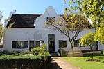 | |
| 9/2/084/0051 | Grosvenor House, Drostdy Street, Stellenbosch | Grosvenor House is situated next to the Dutch Reformed Church in Drostdy Street. Grosvenor House is associated with the oldest and best-known Stellenbosch and, therefore, South African families. The land on which it stands was granted to Christiaan Ludolph Neethling in 1781. He came to the Cape from Germany in 1741 and became the progenitor of this widespread Afrikaans family. The building also provides a clear demonstration of how a simple structure could develop into a worthy example of Cape architecture. The house that Christiaan Neethling built consisted of a row of single-storeyed thatched rooms in Drostdy Street. At the end of the 18th and beginning of the 19th centuries a gable was added above the front door and a room was built on at the back which gave the building the shape of a T. Later additions made it into a full-scale H-shaped house. The sick-comforter, Herold, F added a second storey with a flat roof, an alteration that was at first probably confined to the front part of the house. These changes gave the house a completely new façade: four fluted pilasters with a richly ornamented cornice; a teak stable-door framed by shorter, ribbed pilasters; teak sash-windows with inner shutters of stinkwood and, right at the top, a little palm tree in bas relief, taken from the crest of the community. This is how the house still stands today. The outbuildings on either side of the main house were probably also built in Herold time. Frederick Neethling who occupied the house just when the late Georgian style was fashionable, was probably responsible for the wagon-wheel fanlight. The house, a cultural treasure in its own right, is a worthy repository for relics of the history of Stellenbosch and its neighbourhood. | Stellenbosch | Stellenbosch | Provincial Heritage Site | 33°56′07″S 18°51′44″E / 33.935358°S 18.862229°E | 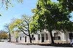 |
| 9/2/084/0052 | Old College Buildings, Stellenbosch | Stellenbosch | Stellenbosch | National Monument |
| ||
| 9/2/084/0053 | 5 Minserie Street, Stellenbosch | Stellenbosch | Stellenbosch | Provincial Heritage Site | 33°56′15″S 18°51′53″E / 33.937436°S 18.864742°E | .JPG) | |
| 9/2/084/0054 | Erfurt house, 37 Ryneveld Street, Stellenbosch | Stellenbosch | Stellenbosch | National Monument | 33°56′07″S 18°51′44″E / 33.935327°S 18.862185°E |
| |
| 9/2/084/0055 | Rhenish Parsonage complex, Market Street, Stellenbosch | All the buildings of the Rhenish Parsonage Complex, built on land granted to Marthinus Byleveld in 1785, date from the beginning of the 19th century. The main building is the former parsonage of the Rhenish Church and dates from 1815. One of the back wings of this H-shaped parsonage is connected with the other two buildings forming part of the complex. Of these the so-called Leipoldt House with its large proportions dates from approximately 1832, while the third building with its low dormer gable was converted into a double-storey in about 1860. On one side, the Rhenish Parsonage Complex is enclosed by a long circular wall. | Stellenbosch | Stellenbosch | Provincial Heritage Site | 33°56′19″S 18°51′18″E / 33.938580°S 18.854910°E |  |
| 9/2/084/0056 | 2 Ryneveld Street, Stellenbosch | Stellenbosch | Stellenbosch | National Monument | 33°56′17″S 18°51′47″E / 33.938129°S 18.863070°E |
| |
| 9/2/084/0057 | Alto, Annendale Road, Stellenbosch District | Stellenbosch | Stellenbosch | National Monument (?) | 34°00′10″S 18°50′49″E / 34.002838°S 18.846985°E |
| |
| 9/2/084/0058 | Erf 3759, Schroder Street, Stellenbosch | Stellenbosch | Stellenbosch |
| |||
| 9/2/084/0059 | Faure House, Stellenbosch | Stellenbosch | Stellenbosch | 34°01′36″S 18°44′56″E / 34.026677°S 18.748852°E |
| ||
| 9/2/084/0060 | Van der Bijl House, 37 Market Street, Stellenbosch | This property forms part of the former farm known as Oude Molen. Adriaan Roux bought the property in 1806 and erected the present house shortly afterwards. It has been in the possession of the Van der Bijl family since 1848. | Stellenbosch | Stellenbosch | Provincial Heritage Site | 33°56′19″S 18°51′18″E / 33.938580°S 18.854910°E | 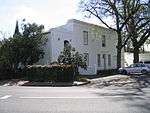 |
| 9/2/084/0060/001 | Van der Bijl Cottage, 37A Market Street, Stellenbosch | The original two-roomed Van der Bijl cottage was built in c. 1820, probably as a gardener's cottage. Although extended during its restoration in 1979–1980 the building retains much of its original character and scale. As part of the historical Van der Bijl House complex the cottage not only forms an important and integral part of the aspect of this National Monument, but also contributes to the surrounding historical streetscape. | Stellenbosch | Stellenbosch | Register | 33°56′19″S 18°51′17″E / 33.938527°S 18.854792°E | 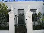 |
| 9/2/084/0061 | 155 Dorp Street, Stellenbosch | Just as the three single-storeyed semi-detached houses at Nos. 153, 155 and 157 are still linked together, the various families who occupied them throughout the years were often also linked. Nos. 155 and 157 Dorp Street with their modest gables and are also architecturally important. | Stellenbosch | Stellenbosch | Provincial Heritage Site | 33°56′20″S 18°51′44″E / 33.9387694444°S 18.8622333333°E | .JPG) |
| 9/2/084/0062 | The Braak, Stellenbosch | Town common (braak means "fallow land") bounded on the north by Alexander Street, on the east by Bird Street, Mill Square and the Church of the Rhenish Mission, on the south by property transferred to J. W. Palen, and on the west by Bloem Street, and the Church of the Rhenish Mission. | Stellenbosch | Stellenbosch | Provincial Heritage Site | 33°56′14″S 18°51′31″E / 33.937097°S 18.858676°E |  |
| 9/2/084/0063 | Powder Magazine, Blom Street, Stellenbosch | The Braak derives its unique character from the buildings that surround it and one of these is the well-known Powder Magazine. It has been converted into a small museum of relics of the military history of Stellenbosch. | Stellenbosch | Stellenbosch | Provincial Heritage Site | 33°56′13″S 18°51′30″E / 33.937069°S 18.858274°E | 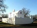 |
| 9/2/084/0064 | La Gratitude, 95 Dorp Street, Stellenbosch | La Gratitude was built by the Rev. Meent Borcherds, the parson at Stellenbosch from 1786 to 1830, in 1798. He was born at Jangum, East Friesland, in 1762. The house is a U-shaped building with one of the earliest neo-classical pilaster-gables. The pilasters are repeated between the windows. This gives an exceptional dignity to the facade and creates an air of aristocratic pride. | Stellenbosch | Stellenbosch | Provincial Heritage Site | 33°56′21″S 18°51′29″E / 33.939206°S 18.857919°E | 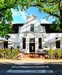 |
| 9/2/084/0065 | Tuinpoort, Plein Street, Stellenbosch | Plein Street, one of the three oldest streets in Stellenbosch, runs from the Braak through the town to Jonkershoek. Opposite the Town Hall, almost hidden between modern business buildings, there is an attractive little gateway with beautiful baroque gables in the style that stood in Plein Street at the end of the 19th century. For many years it was thought to be the entrance to the old graveyard, but later researches and a drawing of Stellenbosch made in 1710 prove that this could not have been the case. The fact that it can no longer be regarded as the entrance to the old cemetery does not detract in the least from its beauty or its architectural and cultural-historical values. | Stellenbosch | Stellenbosch | Provincial Heritage Site | 33°56′13″S 18°51′40″E / 33.937051°S 18.861015°E |  |
| 9/2/084/0066 | Burgher House, Blom Street, Stellenbosch | There are other exceptional buildings round the Braak; one of the most striking of them is the Burgher House with its fine early pilastered front. It dates to the end of the 18th century and is one of several houses built by Anthonie Fick. Fick acquired the land in 1796 or just before that date, and by the following year this house had already been built. In the course of time several alterations were certainly made to the building, but it was originally built in the form of an H and the distinctive brick and plaster architrave above the front door had survived. This house is an exceptionally fine example of Old Cape Dutch architecture. | Stellenbosch | Stellenbosch | Provincial Heritage Site | 33°56′13″S 18°51′30″E / 33.936980°S 18.858255°E |  |
| 9/2/084/0068 | Clock, Administration Building B, University of Stellenbosch, Victoria Street, Stellenbosch | The case of the clock, made of stinkwood, yellowwood and ebony, is most elegant. The heavy base which rests on carved, moulded feet, is particularly striking. From the base there rises the elegant, slender case. The clock is probably the only surviving one that was made at the Cape during the 18th century. It was made by Johann Michael Junck who arrived at the Cape from Furfeld in Germany in the ship Bleijswijk in 1765. This old grandfather clock is an outstanding example of the fine craftsmanship that was practised at the Cape during the 18th century. | Stellenbosch | Stellenbosch | Heritage Object | 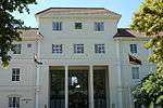 | |
| 9/2/084/0069 | St Mary's Church, The Braak, Stellenbosch | St. Mary's Church stands on the corner of the Braak opposite the Drostdy Hotel. This quaint church with its thatched roof has in effect become a part of the history of the Braak and, like the Rhenish Church and the Powder Magazine, makes a notable contribution to its character. This property is, on account of its architectural merits and its situation on The Braak, regarded as a historical monument. | Stellenbosch | Stellenbosch | Provincial Heritage Site | 33°56′14″S 18°51′31″E / 33.937097°S 18.858676°E |  |
| 9/2/084/0070 | Divisional Council Building, 46 Alexander Street, Stellenbosch | The Divisional Council Offices and the Drostdy Hotel stand just above the so-called Coachman’s Cottage. The former is a comparatively recent building, while the Drostdy Hotel is older and has its own history. Although it might be difficult to justify the proclamation of these buildings on strictly historical grounds, they have considerable architectural merit and are of such a character that they fit in well with the Braak and the surrounding buildings. For these reasons and to ensure the preservation of the harmonious appearance of this area the facades of these buildings facing the Braak have been proclaimed. | Stellenbosch | Stellenbosch | Provincial Heritage Site | 33°56′10″S 18°51′18″E / 33.936236°S 18.855138°E | .JPG) |
| 9/2/084/0071 | First Gymnasium, 120 Dorp Street, Stellenbosch | Just a short distance higher up from La Gratitude on the left side of Dorp Street, stands a modest little building with a peculiar verandah. It looks rather out of place among the rest of the buildings by which it is squeezed in. This is the Stellenbosch Gymnasium from which the Paul Roos Gymnasium and the University of Stellenbosch developed. | Stellenbosch | Stellenbosch | Provincial Heritage Site | 33°56′23″S 18°51′23″E / 33.939601°S 18.856342°E |  |
| 9/2/084/0072 | Old Rhenish School Hostel, 3 Blom Street, Stellenbosch | On the western side of the Braak, not far from the well-known little Rhenish Church, stands the Rhenish Hostel, the oldest girls’ boarding school in our country. Apart from the historical significance of the building, its interesting architectural style imparts a special character to the Braak as an early 19th-century town square. Together with the Rhenish Church, the Burgher House, the St. Mary’s Church, the Coachman’s House, Laetitia and other buildings, the square forms a unique architectural complex. | Stellenbosch | Stellenbosch | Provincial Heritage Site | 33°55′48″S 18°40′45″E / 33.929920°S 18.679160°E | 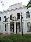 |
| 9/2/084/0073 | Saxenhof, 159 Dorp Street, Stellenbosch | The double-storeyed house, Saxenhof, was formerly also known as Neethling House. The land on which this house stands was granted to Pieter Andriesz Saxe already in 1704. He owned the place for sixteen years and it is accepted that it was he who built the original H-shaped Cape Dutch house. In 1889 the house was sold to Dr. Johannes Henoch Neethling, who shortly after converted the old single-storeyed house into a charming Georgian type double-storeyed house. The original and beautiful old ceilings as well as a few side and back windows of the old house were kept intact. | Stellenbosch | Stellenbosch | Provincial Heritage Site | 33°56′20″S 18°51′45″E / 33.9387833333°S 18.8625166666°E | 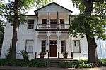 |
| 9/2/084/0074 | Hauptfleisch House, 153 Dorp Street, Stellenbosch | Just as the three single-storeyed semi-detached houses at Nos. 153, 155 and 157 are still linked together, the various families who occupied them throughout the years were often also linked. | Stellenbosch | Stellenbosch | Provincial Heritage Site | 33°56′20″S 18°51′43″E / 33.9388194444°S 18.8620777777°E |  |
| 9/2/084/0075 | Vredelus and Klein Vredelus, 63 Dorp Street, Stellenbosch | This old house possesses a special kind of charm and mysteriousness, because it stands concealed behind a white wall and an extensive garden with lofty oak-trees, luxuriant shrubs, lawns and flowers. The houses are good examples of the architecture in Stellenbosch between the 18th and 19th centuries and are also of historical interest. They have been restored by Historic Houses Limited and lend a particular character to the town of Stellenbosch. | Stellenbosch | Stellenbosch | Provincial Heritage Site | 33°56′25″S 18°51′18″E / 33.940265°S 18.854940°E |  |
| 9/2/084/0076 | Loubscher House, 157 Dorp Street, Stellenbosch | Just as the three single-storeyed semi-detached houses at Nos. 153, 155 and 157 are still linked together, the various families who occupied them throughout the years were often also linked. Nos. 155 and 157 with their modest gables are also architecturally important. No. 157 Dorp Street is indeed one of the few houses with a roundel motif on the pilasters on either side of the gable-window. | Stellenbosch | Stellenbosch | Provincial Heritage Site | 33°56′19″S 18°51′44″E / 33.9386194444°S 18.8623472222°E |  |
| 9/2/084/0077 | Ou Bakhuis, 152 and 154 Dorp Street, Stellenbosch | Stellenbosch | Stellenbosch | Provincial Heritage Site | 33°56′19″S 18°51′44″E / 33.9386444444°S 18.8621388888°E |  | |
| 9/2/084/0078 | Libertas Parva, Dorp Street, Stellenbosch | A short distance from the railway station at the corner which Dorp Street forms with Somerset West Road, stands the first remarkable old house in this street. It is called Libertas Parva or Little Libertas and it is on the right side of the street (now Rembrandt van Rijn Art Centre). The oldest feature of the house is its four side gables; they are of the holbol type, but show a breaking up of the concaves and convexes into wavy lines reminiscent of a similar tendency in the front gables of the Zevenrivieren-Hazendal type, c, 1790. The house may therefore date from 1783 or soon after. Philip Jacob Haupt purchased the farm in 1819 and it must be accepted that he was responsible for the erection of the present front gable, with almost straight outlines, with the two front doors built in and also for the Georgian windows. Their outer surrounding pilasters are continued upward to form the outer gable pilasters. The Libertas Parva building complex is a fine example of the Stellenbosch architecture in the 18th and 19th centuries and lends a particular character to that part of the village. As the home of well-known Stellenbosch families it is also of great historic value. | Stellenbosch | Stellenbosch | Provincial Heritage Site | 33°56′23″S 18°51′23″E / 33.939601°S 18.856342°E |  |
| 9/2/084/0079 | Diaconies Remise, 156 Dorp Street, Stellenbosch | No. 156 Dorp Street bears the venerable name of Diaconies Remise and it was purchased by Historical Homes of South Africa Ltd. on account of its historical and architectural value. The style of architecture indicates that it was built in the first decade of the 19th century. The house is also one of the very few with an authentic arched gateway next to the main building. This gate gives access from the street to the back-yard. | Stellenbosch | Stellenbosch | Provincial Heritage Site | 33°56′19″S 18°51′39″E / 33.9384972222°S 18.8609694444°E |  |
| 9/2/084/0080 | Laetitia Building, 44 Alexander Street, Stellenbosch | Just above the so-called Coachman’s Cottage stands Laetitia, a double-storeyed, flat-roofed house which overlooks the Braak. In 1968 Laetitia was restored by Historical Homes of South Africa Ltd. Being representative of a specific style of architecture and situated in a prominent position at the north-western corner of the Braak, it enhances the importance and charm of this unique square at Stellenbosch. | Stellenbosch | Stellenbosch | Provincial Heritage Site | 33°56′08″S 18°51′29″E / 33.935611°S 18.857924°E |  |
| 9/2/084/0081 | 158 Dorp Street, Stellenbosch | Stellenbosch | Stellenbosch | Provincial Heritage Site | 33°56′19″S 18°51′40″E / 33.9385194444°S 18.8611472222°E | 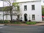 | |
| 9/2/084/0082 | Old Evangelical Lutheran Church, Dorp Street, Stellenbosch | This building in the Neo-Gothic style was designed and erected by Carl Otto Hager. It was originally used as a Lutheran Church after its consecration on 28 November 1854. | Stellenbosch | Stellenbosch | Provincial Heritage Site | 33°56′23″S 18°51′23″E / 33.939601°S 18.856342°E | 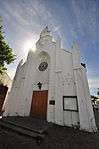 |
| 9/2/084/0083 | Old Main Building, University of Stellenbosch, Ryneveld Street, Stellenbosch | This building was erected between 1880 and 1886 to provide proper housing for the Stellenbosch College. This so-called Main Building is in the Neo-Classical style, Carl Hager being the architect, and played an important part in the history of the Victoria College and later the University of Stellenbosch. | Stellenbosch | Stellenbosch | Provincial Heritage Site | 33°55′53″S 18°51′43″E / 33.931433°S 18.862026°E | 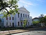 |
| 9/2/084/0084 | Entrance and gates, Seminary, 171 Dorp Street, Stellenbosch | The gateway and gates which were erected at about 1769 as part of the Drostdy at that time, are situated on the most historic site in Stellenbosch. This site has associations with Simon van der Stel and the respective Drostdy buildings were formerly also situated here until, in 1859, they became the seat of the Theological Seminary. | Stellenbosch | Stellenbosch | Provincial Heritage Site | 33°56′19″S 18°51′50″E / 33.938563°S 18.863925°E |  |
| 9/2/084/0085 | 37, 39 and 41 Herte Street, Stellenbosch | These historic double-storeyed houses were erected in about 1841 as residences for Coloured people and freed slaves and their descendants. | Stellenbosch | Stellenbosch | Provincial Heritage Site | 33°56′15″S 18°51′20″E / 33.937484°S 18.855472°E | 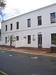 |
| 9/2/084/0086 | 48 and 50 Dorp Street, Stellenbosch | This imposing architectural complex consists of a Cape Dutch house which was erected in about 1815 and a double-storeyed annex which dates back to about 1960. The property is closely associated with two well-known Stellenbosch families, i.e. the Neethlings and Ackermanns. | Stellenbosch | Stellenbosch | Provincial Heritage Site | 33°56′23″S 18°51′14″E / 33.939673°S 18.853993°E | 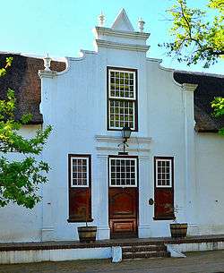 |
| 9/2/084/0090 | Transvalia, 127 Dorp Street, Stellenbosch | These double-storeyed buildings, in the predominantly Georgian style, probably all date from the beginning of the 19th century. This group of houses forms an almost perfect unit and also forms an important element in the street scene of the historic Dorp Street. | Stellenbosch | Stellenbosch | Provincial Heritage Site | 33°56′20″S 18°51′32″E / 33.938989°S 18.858848°E | |
| 9/2/084/0091 | Alma, 129 Dorp Street, Stellenbosch | These double-storeyed buildings, in the predominantly Georgian style, probably all date from the beginning of the 19th century. This group of houses forms an almost perfect unit and also forms an important element in the street scene of the historic Dorp Street. | Stellenbosch | Stellenbosch | Provincial Heritage Site | 33°56′20″S 18°51′39″E / 33.938765°S 18.860952°E |  |
| 9/2/084/0092 | Bosman House, 133 Dorp Street, Stellenbosch | These double-storeyed buildings, in the predominantly Georgian style, probably all date from the beginning of the 19th century. This group of houses forms an almost perfect unit and also forms an important element in the street scene of the historic Dorp Street. | Stellenbosch | Stellenbosch | Provincial Heritage Site | 33°56′20″S 18°51′39″E / 33.938776°S 18.860953°E |  |
| 9/2/084/0093 | Tinetta House, 135 Dorp Street, Stellenbosch | These double-storeyed buildings, in the predominantly Georgian style, probably all date from the beginning of the 19th century. This group of houses forms an almost perfect unit and also forms an important element in the street scene of the historic Dorp Street. | Stellenbosch | Stellenbosch | Provincial Heritage Site | 33°56′20″S 18°51′39″E / 33.938765°S 18.860953°E |  |
| 9/2/084/0094 | 8 Herte Street, Stellenbosch | These properties were granted in 1750 to the landdrost and Heemrade, and to Jan Greyling. The complex of buildings is of special architectural interest and forms an essential part of the historic core of Stellenbosch. | Stellenbosch | Stellenbosch | Provincial Heritage Site | 33°56′21″S 18°51′22″E / 33.939113°S 18.856179°E | .JPG) |
| 9/2/084/0095 | 15 Herte Street, Stellenbosch | These properties were granted in 1750 to the landdrost and Heemrade, and to Jan Greyling. The complex of buildings is of special architectural interest and forms an essential part of the historic core of Stellenbosch. | Stellenbosch | Stellenbosch | Provincial Heritage Site | 33°56′20″S 18°51′21″E / 33.938866°S 18.855720°E | .JPG) |
| 9/2/084/0096 | 19 Herte Street, Stellenbosch | These properties were granted in 1750 to the landdrost and Heemrade, and to Jan Greyling. The complex of buildings is of special architectural interest and forms an essential part of the historic core of Stellenbosch. | Stellenbosch | Stellenbosch | Provincial Heritage Site | 33°56′18″S 18°51′21″E / 33.938459°S 18.855969°E | .JPG) |
| 9/2/084/0097 | 21 Herte Street, Stellenbosch | These properties were granted in 1750 to the landdrost and Heemrade, and to Jan Greyling. The complex of buildings is of special architectural interest and forms an essential part of the historic core of Stellenbosch. | Stellenbosch | Stellenbosch | Provincial Heritage Site | 33°56′17″S 18°51′21″E / 33.938185°S 18.855896°E |  |
| 9/2/084/0098 | 23 Herte Street, Stellenbosch | These properties were granted in 1750 to the landdrost and Heemrade, and to Jan Greyling. The complex of buildings is of special architectural interest and forms an essential part of the historic core of Stellenbosch. | Stellenbosch | Stellenbosch | Provincial Heritage Site | 33°56′17″S 18°51′21″E / 33.938117°S 18.855852°E |  |
| 9/2/084/0099 | Dutch Reformed Mother Church, Drostdy Street, Stellenbosch | A portion of this building originally formed part of the Stellenbosch cruciform church which was erected between 1719 and 1723. In 1862 the church was enlarged and altered in the neo-Gothic style by the architect Carl Otto Hager. The church was consecrated on 31 October 1863. | Stellenbosch | Stellenbosch | Provincial Heritage Site | 33°56′16″S 18°51′49″E / 33.937710°S 18.863718°E |  |
| 9/2/084/0100 | Utopia, 1 Drostdy Street, Stellenbosch | This imposing H-shaped Cape Dutch house was built at the end of the 18th century for Philip Hartog. | Stellenbosch | Stellenbosch | Provincial Heritage Site | 33°56′16″S 18°51′49″E / 33.937710°S 18.863718°E |  |
| 9/2/084/0102 | Wilgenhof, Ryneveld Street, Stellenbosch | The original portion of the historic Bachelors building was erected between 1786 and 1799. The building was later altered into a double-storeyed Georgian house and it was taken into use in 1903 as a boarding establishment for students. It is the oldest portion of the oldest university residence of Stellenbosch and many well-known personalities in the public life of South Africa lodged here during their student years. | Stellenbosch | Stellenbosch | Provincial Heritage Site | 33°55′55″S 18°51′43″E / 33.931876°S 18.862083°E |  |
| 9/2/084/0103 | 105 Dorp Street, Stellenbosch | This historic dwelling-house is a typical double-storeyed town house of the second half of the 19th century. The property forms an essential part of the traditional architectural street scene of Dorp Street, and thus also of the historic core of Stellenbosch. | Stellenbosch | Stellenbosch | Provincial Heritage Site | 33°56′22″S 18°51′31″E / 33.939350°S 18.858660°E | 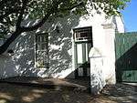 |
| 9/2/084/0104 | Voorgelegen, 116 and 118 Dorp Street, Stellenbosch | This property originally formed part of De Nieuwe Molen, which was granted to the Landdros and Heemrade in 1750. In 1797 it became the property of Johannes Victor, who almost immediately erected the original H-shaped Cape Dutch house. In the second half of the 19th century the building was converted to a Georgian double-storey residence. Together with the outbuildings and the garden ring-wall it forms an outstanding group of buildings from the point of view of architecture and town planning and constitutes an integral part of the street scene of Dorp Street and the historic core of Stellenbosch. The old-world garden with its tranquil atmosphere which is partly due to the mill-stream, is an aesthetic gem which fits in with the unique group of properties surrounding Voorgelegen. | Stellenbosch | Stellenbosch | Provincial Heritage Site | 33°56′21″S 18°51′30″E / 33.939052°S 18.858378°E | 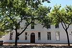 |
| 9/2/084/0105 | 51 Dorp Street, Stellenbosch | This Victorianised house, which was originally erected during the first half of the 19th century, together with seven similar structures, forms one of the most impressive street scenes in Stellenbosch. | Stellenbosch | Stellenbosch | Provincial Heritage Site | 33°56′25″S 18°51′16″E / 33.940292°S 18.854368°E | 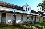 |
| 9/2/084/0106 | Bergh House, 11 Drostdy Street, Stellenbosch | The original portion of this building dates from the middle of the 18th century. It is now a typical example of a double-storeyed town house. The best known owner of the property was Prof. John Murray, one of the first two professors at the Theological Seminary. | Stellenbosch | Stellenbosch | Provincial Heritage Site | 33°56′15″S 18°51′48″E / 33.937502°S 18.863430°E | 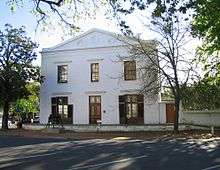 |
| 9/2/084/0107 | 110 Dorp Street, Stellenbosch | The original part of this double-storeyed town house dates from the beginning of the 19th century. The building was later adapted to the Georgian style. The property forms an essential part of the traditional architectural street scene of Dorp Street, and thus also of the historic core of Stellenbosch. | Stellenbosch | Stellenbosch | Provincial Heritage Site | 33°56′20″S 18°51′26″E / 33.938886°S 18.857360°E | .JPG) |
| 9/2/084/0108 | 108 Dorp Street, Stellenbosch | The original part of this historic house dates from the beginning of the 19th century and was later adapted to the Georgian style. It forms an integral part of the architecturally and historically important street scene of Dorp Street. | Stellenbosch | Stellenbosch | Provincial Heritage Site | 33°56′21″S 18°51′26″E / 33.939098°S 18.857273°E | 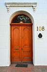 |
| 9/2/084/0109 | 112 Dorp Street, Stellenbosch | This historic house dates from approximately 1798 and was later converted to the Georgian style. It forms an integral part of the architecturally and historically important street scene of Dorp Street. | Stellenbosch | Stellenbosch | Provincial Heritage Site | 33°56′21″S 18°51′28″E / 33.939233°S 18.857719°E |  |
| 9/2/084/0110 | 31 Van Riebeeck Street, Stellenbosch | This predominantly Victorian house dates from the beginning of the 20th century. Owing to the property's strategic position it forms an important aspect of the townscape. | Stellenbosch | Stellenbosch | Provincial Heritage Site | 33°56′12″S 18°52′06″E / 33.936605°S 18.868412°E | .JPG) |
| 9/2/084/0111 | Oude Werf, 30 Church Street, Stellenbosch | This property initially formed the boundary of the original Stellenbosch cemetery which fell into disuse in 1710. In 1783 the plot came into the ownership of J. B. Hoffman, who was presumably responsible for the erection of the original Cape Dutch house. This building was thereafter used as a boarding-house for many decades. By 1889 an additional storey had been added, which gave the building its present imposing Georgian appearance. | Stellenbosch | Stellenbosch | Provincial Heritage Site | 33°56′17″S 18°51′42″E / 33.937938°S 18.861780°E |  |
| 9/2/084/0112 | 149 Dorp Street, Stellenbosch | This house displays a harmonious mixture of Cape Dutch and Georgian characteristics. The oldest portion presumably dates from the beginning of the 18th century. The property forms an essential architectural and aesthetic keystone in the historic core of Stellenbosch. | Stellenbosch | Stellenbosch | Provincial Heritage Site | 33°56′20″S 18°51′43″E / 33.9388°S 18.8619°E |  |
| 9/2/084/0113 | 141 and 143 Dorp Street, Stellenbosch | The original portions of this Cape Dutch house date from the middle of the 18th century and it was first used as parsonage for the Rev. Meent Borcherds. The property forms an essential part of the traditional architectural street scene of Dorp Street, and thus also of the historic core of Stellenbosch. | Stellenbosch | Stellenbosch | Provincial Heritage Site | 33°56′20″S 18°51′40″E / 33.938790°S 18.860985°E | .JPG) |
| 9/2/084/0114 | Van Niekerk House, 47 Church Street, Stellenbosch | This double-storeyed Victorian house is situated on a plot which was granted to Landdrost C. Linnes as early as 1694. The building is closely associated with the historic core of Stellenbosch. | Stellenbosch | Stellenbosch | Provincial Heritage Site | 33°56′17″S 18°51′43″E / 33.937920°S 18.861948°E | .JPG) |
| 9/2/084/0115 | Crozier House, 11 Victoria Street, Stellenbosch | The facade of this late 19th-century building has notable Victorian and Georgian characteristics. The Crozier House earlier formed part of the old College Square of the Victoria College. | Stellenbosch | Stellenbosch | Provincial Heritage Site | 33°56′05″S 18°51′41″E / 33.934752°S 18.861476°E | .JPG) |
| 9/2/084/0116 | 25–35 Herte Street, Stellenbosch | This row of semi-detached cottages with their pointed gables was presumably erected during the middle of the 19th century as accommodation for freed slaves. These properties form an essential part of the historic and architectural character of Herte Street and also of the historic core of Stellenbosch. | Stellenbosch | Stellenbosch | Provincial Heritage Site | 33°56′17″S 18°51′20″E / 33.938000°S 18.855562°E |  |
| 9/2/084/0117 | 126 Dorp Street, Stellenbosch | Stellenbosch | Stellenbosch | Provincial Heritage Site | 33°56′20″S 18°51′32″E / 33.938847°S 18.858852°E |  | |
| 9/2/084/0119 | Hofmeyr Hall, 39 Church Street, Stellenbosch | This neo-classical hall, with its impressive Ionic temple facade, was inaugurated in October 1900. The building was constructed for use by the Christelijke Jongelieden Vereniging, and was named after Prof. N. J. Hofmeyr, founder of the Stellenbosch Seminary and the CJV. | Stellenbosch | Stellenbosch | Provincial Heritage Site | 33°56′16″S 18°51′44″E / 33.937886°S 18.862112°E | 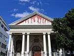 |
| 9/2/084/0120 | Old Conservatory, 10 Van Riebeeck Street, Stellenbosch | The South African Conservatorium of Music, the first conservatory in South Africa, was established in 1905, with Prof. F. W. Jannasch as Director. This double-storey building is built in an interesting mixture of architectural styles. | Stellenbosch | Stellenbosch | Provincial Heritage Site | 33°56′12″S 18°51′55″E / 33.936797°S 18.865340°E |  |
| 9/2/084/0122 | Theological Seminary, 171 Dorp Street, Stellenbosch | The original Drostdy was the first public building in Stellenbosch and was a U-shaped building which was completely rebuilt, in 1763. It was then given an H-shape and the front of a traditional Cape Dutch farmhouse. It served as Drostdy until 1827. In 1859 the building was donated to the D.R. Church and the Theological Seminary was opened there. The building forms an integral part of the historic character of Dorp Street as well as of the historic core of Stellenbosch. | Stellenbosch | Stellenbosch | Provincial Heritage Site | 33°56′19″S 18°51′51″E / 33.9386472222°S 18.8640361111°E | 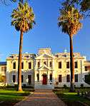 |
| 9/2/084/0123 | 45 Dorp Street, Stellenbosch | This property originally formed part of the farm Vredenlust which was granted to Christoffel Henske in 1781. This cottage is one of a row of six similar semi-detached buildings which were erected between 1817and 1859 in the Cape Dutch style and which were later Victorianised. | Stellenbosch | Stellenbosch | Provincial Heritage Site | 33°56′25″S 18°51′15″E / 33.940370°S 18.854041°E | .JPG) |
| 9/2/084/0124 | 1 Victoria Street, Stellenbosch | These three Victorianised semi-detached cottages were originally erected early in the 19th century. The cottages form an important architectural unit and lend character to the nearby College Square. | Stellenbosch | Stellenbosch | Provincial Heritage Site | 33°56′05″S 18°51′39″E / 33.934607°S 18.860783°E |  |
| 9/2/084/0125 | 62–66 Andringa Street, Stellenbosch | Stellenbosch | Stellenbosch | Provincial Heritage Site | 33°56′05″S 18°51′39″E / 33.934667°S 18.860733°E | .JPG) | |
| 9/2/084/0126 | Skuinshuis Jewish complex, 44 Ryneveld Street, Stellenbosch | The core of this double-storeyed building dates from about 1782. The facade of the house was rebuilt during the first half of the 19th century. The building, together with the historic chicken-coop, forms a unique architectural complex. | Stellenbosch | Stellenbosch | Provincial Heritage Site | 33°56′09″S 18°51′46″E / 33.935862°S 18.862829°E |  |
| 9/2/084/0127 | 20 Crozier Street, Stellenbosch | This Victorian cottage forms part of a row of five semi-detached cottages that date from the late 19th century. | Stellenbosch | Stellenbosch | Provincial Heritage Site | 33°55′59″S 18°51′39″E / 33.933052°S 18.860720°E |  |
| 9/2/084/0128 | 16 Crozier Street, Stellenbosch | This Victorian cottage forms part of a row of five semi-detached cottages that date from the late 19th century. | Stellenbosch | Stellenbosch | Provincial Heritage Site | 33°55′59″S 18°51′38″E / 33.933192°S 18.860505°E | .JPG) |
| 9/2/084/0129 | De Eiken, 25 Market Street, Stellenbosch | This house was occupied from 1854 to 1898 by Carl Otto Hager, well-known church architect, photographer and painter. | Stellenbosch | Stellenbosch | Provincial Heritage Site | 33°56′19″S 18°51′18″E / 33.938580°S 18.854910°E | .JPG) |
| 9/2/084/0131 | 14 Van Riebeeck Street, Stellenbosch | This late-Victorian house, with its exquisite cast-iron latticed veranda, dates from the 1890s. The property forms an important element in the townscape in view of its strategic position. | Stellenbosch | Stellenbosch | Provincial Heritage Site | 33°56′12″S 18°51′57″E / 33.936738°S 18.865816°E | .JPG) |
| 9/2/084/0132 | Old C L Marais Library, Crozier Street, Stellenbosch | Thanks to a generous donation from a benefactor of Stellenbosch, Mr CL Marais, contributions from the Stellenbosch Distriksbank and the Colonial Government, the erection of a library building on the northern side of College Square was started in 1900 and completed in 1901. The new building was named after Mr CL Marais and was the first building in the history of the University which was built for this specific purpose. It did, however, also house the administrative offices of the Victoria College for approximately 20 years and some rooms in the building were used as Council Chambers and Senate committee rooms. | Stellenbosch | Stellenbosch | Provincial Heritage Site | 33°56′00″S 18°51′38″E / 33.933420°S 18.860596°E | .JPG) |
| 9/2/084/0133 | Bergville, 13–15 Victoria Street, Stellenbosch | This predominantly Victorian building consists of two double-storeyed semi-detached houses which form an attractive architectural unit with a joint cornice and parapet wall. The building dates from the late 19th or early 20th century. | Stellenbosch | Stellenbosch | Provincial Heritage Site | 33°56′18″S 18°51′48″E / 33.938284°S 18.863289°E | 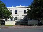 |
| 9/2/084/0134 | Red House, 68 Kahler Street, Idas Valley, Stellenbosch | This impressive dwelling-house with its true Victorian features dates from the 19th century and is allegedly one of the oldest houses in the old Coloured area of ldasvallei. | Stellenbosch, Idas Valley | Stellenbosch | Provincial Heritage Site | 33°55′14″S 18°53′00″E / 33.920527°S 18.883286°E | 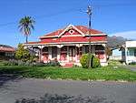 |
| 9/2/084/0135 | Thaba 'Nchu, 5 Rattray Avenue, Stellenbosch | Thaba 'Nchu is a single storeyed semi-detached house in the high Victorian style, which was built in 1900 by James Rattray, the grandson of a British teacher brought over from England by Lord Charles Somerset. Thaba 'Nchu is not only a typical example of late Victorian houses erected in Stellenbosch at the turn of the century, but is also the only one of its kind which has been restored to its authentic colour scheme, an important feature being the simulated brick pattern of the outside walls. The walls are plastered with a raised narrow moulding applied in the first instance in a brickwork design and then painted black. From a distance the black lines against the ochre coloured plaster gives the impression that the wall is constructed of brick. The rustication is accentuated by white paint. The stoep is covered by a candy-striped curved corrugated-iron verandah, supported on cast-iron pillars which are decorated with delicate flower-and-leaves tracery. The section of the wall above the verandah and below the eaves has been painted white with black etchings, giving it a Tudor look. The large, gracefully curved, wooden end-gable was completely re-fashioned during restoration. | Stellenbosch | Stellenbosch | Provincial Heritage Site | 33°56′17″S 18°52′02″E / 33.937979°S 18.867329°E | .jpg) |
| 9/2/084/0136 | 41 Dorp Street, Stellenbosch | These two Victorianised houses, which were originally erected during the first half of the 19th century, together with six other similar buildings, form one of the most charming and harmonious street scenes in Stellenbosch. | Stellenbosch | Stellenbosch | Provincial Heritage Site | 33°56′25″S 18°51′14″E / 33.940373°S 18.853827°E | .JPG) |
| 9/2/084/0137 | 49 Dorp Street, Stellenbosch | These two semi-detached cottages form part of a row of eight similar semi-detached cottages that were erected between 1817 and 1859 in the Cape Dutch style and that were later Victorianised. The cottages form an important visual element of the historical character of Dorp Street in Stellenbosch. | Stellenbosch | Stellenbosch | Provincial Heritage Site | 33°56′25″S 18°51′15″E / 33.940315°S 18.854264°E | 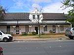 |
| 9/2/084/0138 | Caledon Villa, 7 Neethling Street, Stellenbosch | This impressive dwelling-house with its Edwardian and Victorian characteristics was erected in 1910 by the Rev. J. G. J. Krige of Caledon as a retirement home. | Stellenbosch | Stellenbosch | Provincial Heritage Site | 33°56′15″S 18°51′57″E / 33.937513°S 18.865886°E |  |
| 9/2/084/0139 | 4 Neethling Street, Stellenbosch | This dwelling with its curved verandah and cast-iron decorations is one of two identical late-Victorian semi-detached houses that form an integral part of the architectural street scene of Neethling Street, as well as of the historical core of Stellenbosch. | Stellenbosch | Stellenbosch | Provincial Heritage Site | 33°56′17″S 18°52′00″E / 33.938151°S 18.866739°E | .JPG) |
| 9/2/084/0140 | Nietgevonden, Stellenbosch District | Stellenbosch | Stellenbosch | National Monument | 33°54′08″S 18°50′32″E / 33.902249°S 18.842152°E |
| |
| 9/2/084/0142 | 26–30 Andringa Street, Stellenbosch | Stellenbosch | Stellenbosch | Provincial Heritage Site | 33°56′10″S 18°51′39″E / 33.936162°S 18.860881°E | 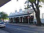 | |
| 9/2/084/0143 | 162 Dorp Street, Stellenbosch | Stellenbosch | Stellenbosch | Provincial Heritage Site | 33°56′18″S 18°51′48″E / 33.9384611111°S 18.8633277777°E | 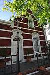 | |
| 9/2/084/0144 | 13 Herte Street, Stellenbosch | Stellenbosch | Stellenbosch | Provincial Heritage Site | 33°56′20″S 18°51′21″E / 33.938943°S 18.855832°E | .JPG) | |
| 9/2/084/0145 | 19 Herold Street, Stellenbosch | Stellenbosch | Stellenbosch | Provincial Heritage Site | 33°56′18″S 18°51′07″E / 33.938415°S 18.851993°E |  | |
| 9/2/084/0146 | Old Labourers' Cottages, Aan-de-Wagen Road, Stellenbosch | These farm-hands' cottages date from the year 1902 and were probably designed by Sir Herbert Baker, the architect. | Stellenbosch | Stellenbosch | Provincial Heritage Site | 33°57′15″S 18°51′20″E / 33.954133°S 18.855681°E |  |
| 9/2/084/0147 | Old Bloemhof Girls' Primary School, 52 Ryneveld Street, Stellenbosch | The building of the Bloemhof Girls' Primary School, which was opened on 2 June 1907, is an outstanding example of the eclectic style of building of the late 19th and early 20th centuries. Together with other historic buildings in Ryneveld Street it forms a unique historical and architectural group. | Stellenbosch | Stellenbosch | Provincial Heritage Site | 33°56′08″S 18°51′46″E / 33.935654°S 18.862701°E | 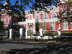 |
| 9/2/084/0148 | 37 Dorp Street, Stellenbosch | These two Victorianised houses, which were originally erected during the first half of the 19th century, together with six other similar buildings, form one of the most charming and harmonious street scenes in Stellenbosch. | Stellenbosch | Stellenbosch | Provincial Heritage Site | 33°56′25″S 18°51′13″E / 33.940404°S 18.853602°E |  |
| 9/2/084/0149 | 39 Dorp Street, Stellenbosch | These two Victorianised houses, which were originally erected during the first half of the 19th century, together with six other similar buildings, form one of the most charming and harmonious street scenes in Stellenbosch. | Stellenbosch | Stellenbosch | Provincial Heritage Site | 33°56′25″S 18°51′13″E / 33.940393°S 18.853725°E |  |
| 9/2/084/0150 | 18 Crozier Street, Stellenbosch | Stellenbosch | Stellenbosch | Provincial Heritage Site | 33°55′59″S 18°51′38″E / 33.9331722222°S 18.8606222222°E |  | |
| 9/2/084/0151 | 22, 24 and 26 Crozier Street, Stellenbosch | Stellenbosch | Stellenbosch | Provincial Heritage Site | 33°56′00″S 18°51′39″E / 33.933366°S 18.860777°E |  | |
| 9/2/084/0153 | Coopman House, 33 Church Street, Stellenbosch | This historic dwelling-house is a typical Georgian double-storeyed town house of the mid-18th century. The property forms an essential part of the traditional architectural street scene of Church Street, and therefore also of the historic core of Stellenbosch. | Stellenbosch | Stellenbosch | Provincial Heritage Site | 33°56′17″S 18°51′43″E / 33.938013°S 18.861963°E |  |
| 9/2/084/0154 | Ryneveldhof, Stellenbosch | Stellenbosch | Stellenbosch | Provincial Heritage Site | 33°55′55″S 18°51′43″E / 33.931876°S 18.862083°E |  | |
| 9/2/084/0154/001 | 89 Banhoek Road, Stellenbosch | Part of Ryneveldhof (corner of Banhoek and Ryneveld Streets) | Stellenbosch | Stellenbosch | Provincial Heritage Site | 33°55′48″S 18°51′56″E / 33.930004°S 18.865622°E |  |
| 9/2/084/0154/002 | 91 Banhoek Road, Stellenbosch | Part of Ryneveldhof (corner of Banhoek and Ryneveld Streets) | Stellenbosch | Stellenbosch | Provincial Heritage Site | 33°55′48″S 18°51′56″E / 33.930004°S 18.865622°E | |
| 9/2/084/0154/003 | 93 Banhoek Road, Stellenbosch | Part of Ryneveldhof (corner of Banhoek and Ryneveld Streets) | Stellenbosch | Stellenbosch | Provincial Heritage Site | 33°55′48″S 18°51′56″E / 33.930004°S 18.865622°E | |
| 9/2/084/0154/004 | 83 Ryneveld Street, Stellenbosch | Part of Ryneveldhof | Stellenbosch | Stellenbosch | Provincial Heritage Site | 33°56′00″S 18°51′44″E / 33.933320°S 18.862157°E |  |
| 9/2/084/0154/005 | 81 Ryneveld Street, Stellenbosch | Part of Ryneveldhof | Stellenbosch | Stellenbosch | Provincial Heritage Site | 33°56′00″S 18°51′44″E / 33.933320°S 18.862157°E | |
| 9/2/084/0154/006 | 79 Ryneveld Street, Stellenbosch | Part of Ryneveldhof | Stellenbosch | Stellenbosch | Provincial Heritage Site | 33°56′00″S 18°51′44″E / 33.933320°S 18.862157°E |  |
| 9/2/084/0154/007 | 77 Ryneveld Street, Stellenbosch | Part of Ryneveldhof | Stellenbosch | Stellenbosch | Provincial Heritage Site | 33°56′00″S 18°51′44″E / 33.933320°S 18.862157°E | |
| 9/2/084/0154/008 | 75 Ryneveld Street, Stellenbosch | Part of Ryneveldhof | Stellenbosch | Stellenbosch | Provincial Heritage Site | 33°56′00″S 18°51′44″E / 33.933320°S 18.862157°E |  |
| 9/2/084/0154/009 | 73 Ryneveld Street, Stellenbosch | Part of Ryneveldhof | Stellenbosch | Stellenbosch | Provincial Heritage Site | 33°56′00″S 18°51′44″E / 33.933320°S 18.862157°E | |
| 9/2/084/0154/010 | 71 Ryneveld Street, Stellenbosch | Stellenbosch | Stellenbosch | Provincial Heritage Site | 33°56′00″S 18°51′44″E / 33.933320°S 18.862157°E | .JPG) | |
| 9/2/084/0154/011 | 69 Ryneveld Street, Stellenbosch | Stellenbosch | Stellenbosch | Provincial Heritage Site | 33°56′00″S 18°51′44″E / 33.933320°S 18.862157°E | .JPG) | |
| 9/2/084/0155 | 5 Ryneveld Street, Stellenbosch | Stellenbosch | Stellenbosch | National Monument | 33°56′17″S 18°51′47″E / 33.938141°S 18.863075°E |
| |
| 9/2/084/0156 | Cloetesdal, Cloetesville, Stellenbosch | Stellenbosch | Stellenbosch | 33°43′46″S 18°59′20″E / 33.729440°S 18.988938°E |
| ||
| 9/2/084/0157 | Spier, Stellenbosch District | Stellenbosch | Stellenbosch | 33°58′56″S 18°47′11″E / 33.982209°S 18.786467°E |
| ||
| 9/2/084/0158 | Morkel House, 4–6 Ryneveld Street, Stellenbosch | Morkel House, the second last house on the eastern side of Ryneveld Street before its intersection with Dorp Street, is one of the oldest building structures in South Africa. For this reason it is of great importance both historically and architecturally. | Stellenbosch | Stellenbosch | Provincial Heritage Site | 33°56′17″S 18°51′47″E / 33.937997°S 18.863027°E |  |
| 9/2/084/0159 | Compagnies Drift, Meerlust, Stellenbosch District | Stellenbosch | Stellenbosch | National Monument |
| ||
| 9/2/084/0160 | Dagbreek Hostel, Victoria Street, Stellenbosch | Stellenbosch | Stellenbosch | Pending Declaration | 33°55′58″S 18°52′09″E / 33.932749°S 18.869089°E |
| |
| 9/2/084/0161 | Morgenhof, Stellenbosch District | Stellenbosch | Stellenbosch | Pending Register | 33°53′38″S 18°51′39″E / 33.893768°S 18.860878°E |
| |
| 9/2/084/0163 | Oude Molen complex, Stellenbosch | Stellenbosch | Stellenbosch | National Monument | 33°56′23″S 18°50′51″E / 33.939747°S 18.847529°E |
| |
| 9/2/084/0164 | Nyasa House, 13 Van Riebeeck Street, Stellenbosch | Stellenbosch | Stellenbosch | 33°56′13″S 18°51′57″E / 33.937054°S 18.865742°E |
| ||
| 9/2/084/0165 | Rozenhof, 8-18 Dorp Street, Stellenbosch | Stellenbosch | Stellenbosch | 33°56′26″S 18°51′00″E / 33.940461°S 18.850100°E |
| ||
| 9/2/084/0166 | STELLENBOSCH MAGISTERIAL DISTRICT, GENERAL | Stellenbosch | Stellenbosch |
| |||
| 9/2/084/0167 | Scholtzenhof, Stellenbosch District | Stellenbosch | Stellenbosch | 34°01′33″S 18°49′09″E / 34.025866°S 18.819292°E |
| ||
| 9/2/084/0168 | 6 Neethling Street, Stellenbosch | Stellenbosch | Stellenbosch | 33°56′17″S 18°52′00″E / 33.938065°S 18.866713°E |
| ||
| 9/2/084/0169 | Uitkyk, Stellenbosch District | Stellenbosch | Stellenbosch | 33°51′24″S 18°51′51″E / 33.856607°S 18.864151°E |
| ||
| 9/2/084/0170 | Bonfoi, Stellenbosch District | Stellenbosch | Stellenbosch | 33°56′30″S 18°46′32″E / 33.941760°S 18.775447°E |
| ||
| 9/2/084/0172 | 67 Ryneveld Street, Stellenbosch | Stellenbosch | Stellenbosch | National Monument | 33°56′07″S 18°51′46″E / 33.935258°S 18.862784°E |
| |
| 9/2/084/0173 | 12 Neethling Street, Stellenbosch | Stellenbosch | Stellenbosch | National Monument | 33°56′15″S 18°51′59″E / 33.937444°S 18.866491°E |
| |
| 9/2/084/0175 | Rhenish Primary School, 5 Bloem Street, Stellenbosch | Stellenbosch | Stellenbosch | 33°56′48″S 18°51′20″E / 33.946720°S 18.855596°E |
| ||
| 9/2/084/0176 | Graves, Farm Welmoed, Stellenbosch District | Stellenbosch | Stellenbosch | National Monument | 33°59′26″S 18°45′59″E / 33.990592°S 18.766258°E |
| |
| 9/2/084/0177 | Groene Rivier Annexure B (Groenvlei), Farm 570, Stellenbosch District | Stellenbosch | Stellenbosch |
| |||
| 9/2/084/0178 | 47 Dorp Street, Stellenbosch District | Stellenbosch | Stellenbosch | 33°56′25″S 18°51′15″E / 33.940334°S 18.854153°E |
| ||
| 9/2/084/0179 | Welgevallen Archaeological Site, Stellenbosch District | Stellenbosch | Stellenbosch |
| |||
| 9/2/084/0180 | Koloniesland, Stellenbosch | Stellenbosch | Stellenbosch |
|
Heritage sites near Stellenbosch town
| SAHRA identifier | Site name | Description | Town | District | NHRA status | Coordinates | Image |
|---|---|---|---|---|---|---|---|
| 9/2/083/0001 | Old Dutch Reformed Church, Church Street, Somerset West | The old Dutch Reformed Church in Somerset West is situated between Church and Victoria Streets, not far from the main street.
The congregation of Hottentots Holland was established in 1819, three years before the town of Somerset West came into being.
|
Cape Town, Somerset West | Somerset West | Provincial Heritage Site | 34°05′12″S 18°50′47″E / 34.086737°S 18.84633°E |  |
| 9/2/083/0002 | Parel Vallei, Aberdeen Road, Somerset West | In the immediate vicinity of Somerset West lie a number of old historic farms with their Cape-Dutch homesteads which fill every lover of the Boland with nostalgia.
One of these farms is Parel Vallei.
Parel Vallei Road branches off the main road inside Som
Architectural style: Cape Gabled, with significant layering.
|
Cape Town, Somerset West | Somerset West | Provincial Heritage Site | 34°04′02″S 18°51′19″E / 34.067124°S 18.855244°E |
|
| 9/2/083/0003 | Bridgewater Manor, Somerset West | Somerset West | Somerset West | 34°05′23″S 18°51′20″E / 34.089732°S 18.855490°E |
| ||
| 9/2/083/0004 | SOMERSET WEST MUNICIPAL AREA, GENERAL | Somerset West | Somerset West |
| |||
| 9/2/083/0005 | Helderberg College Road: Avenue of Trees, Somerset West | Somerset West | Somerset West | 34°03′38″S 18°50′16″E / 34.060568°S 18.837649°E |
| ||
| 9/2/083/0006 | Morgenster, Lourens Road, Somerset West District | The house is H-shaped with 6 really perfect gables; the front gable (recently well rebuilt) is dated 1786 and shows the holbol style at its most beautiful, with convex edge mouldings continued onto the gable face and ending as fully developed scrolls, the nucleus of this farm consisted of the third of the 4 parts into which Vergelegen was divided after the recall of Willem Adriaan van der Stel; it was bought by Jacques Malan.
Malan’s daughter Catharina married Willem Morkel of Onverwacht, and their son
Architectural style: Cape Gabled.
|
Cape Town | Somerset West | Provincial Heritage Site | 34°04′42″S 18°52′01″E / 34.078434°S 18.866819°E |
|
| 9/2/083/0006/01 | Upper Morgenster, remainder of Farm 1319, Morgenster, Somerset West | Somerset West | Somerset West | 34°05′02″S 18°53′06″E / 34.083949°S 18.884953°E |
| ||
| 9/2/083/0007 | Gantouw Pass, Somerset West District | The occupation of the Hottentots Holland Valley by Willem Adriaan van der Stel halted the eastward expansion of the Colony for a time and it was only after his dismissal in 1707 that the trek over the Hottentots Holland Mountains began.
The steep and dang
|
Cape Town | Somerset West | Provincial Heritage Site | 34°08′21″S 18°56′25″E / 34.139184°S 18.940279°E |  |
| 9/2/083/0008 | Voorburg, Victoria Street, Somerset West | Architectural style: Cape Gabled.
|
Cape Town, Somerset West | Somerset West | Provincial Heritage Site | 34°05′25″S 18°50′20″E / 34.090319°S 18.838751°E |
|
| 9/2/083/0009 | Zandvliet, Faure, Somerset West | Somerset West | Somerset West |
| |||
| 9/2/083/0010 | Vergelegen, Somerset West | Somerset West | Somerset West | 34°04′38″S 18°51′43″E / 34.077178°S 18.861907°E |  | ||
| 9/2/083/0010/001 | Camphor trees, Vergelegen, Somerset West | The historical farm Vergelegen lies a few kilometres due east of Somerset West in an angle between the Hottentots Holland Mountains and the Helderberg.
It was granted to Governor Willem Adriaan van der Stel by the visiting Commissioner Wouter Valckenier.
|
Cape Town, Somerset West | Somerset West | Provincial Heritage Site | 34°04′38″S 18°53′00″E / 34.077174°S 18.883349°E | 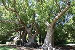 |
| 9/2/083/0011 | SIR LOWRY'S PASS VILLAGE, SOMERSET WEST DISTRICT, GENERAL | Somerset West | Somerset West |  | |||
| 9/2/083/0011/001 | Railway Station, Sir Lowry's Pass Village | Type of site: Railway Station.
|
Cape Town, Sir Lowry's Pass Village | Somerset West | Provincial Heritage Site | 34°07′05″S 18°54′47″E / 34.118060°S 18.913060°E |
|
| 9/2/083/0011/003 | Sweet Safraan, Sir Lowry's Pass Village, Somerset West District | The original dwelling consisted of a central passage with two rooms leading off it on either side, making it a four room house with a thatched roof, At a later date two more rooms were built onto the right-hand side leading directly out of the original t The property on which this dwelling—house is situated, originally formed part of a freehold grant to C.F.Prenger from Cologne in 1779 and named Frederiksburg.
It was subdivided in 1830 and this portion came in the possession of the widow J.C whose husband
|
Cape Town, Sir Lowry's Pass | Somerset West | Provincial Heritage Site | 34°07′08″S 18°54′33″E / 34.118866°S 18.909053°E |  |
| 9/2/083/0011/2 | Old Primary School, Sir Lowry's Pass Village, Somerset West District | Somerset West | Somerset West | 34°07′13″S 18°54′24″E / 34.120283°S 18.906679°E |
| ||
| 9/2/083/0012 | Predikants Square, Somerset West | Type of site: Public open space.
|
Cape Town, Somerset West | Somerset West | Provincial Heritage Site | 34°05′03″S 18°50′29″E / 34.084130°S 18.841370°E |  |
| 9/2/083/0013 | Old Dovecot, Farm 811, Overwacht (De Bosch/Die Bos), Somerset West District | Somerset West | Somerset West | %2C_Somerset_West..jpg) | |||
| 9/2/083/0013/001 | Old Dovecot, Onverwacht 811, Somerset West District | Type of site: Dovecote This dovecot is a particularly good example of the dovecots often built on old farms. | Cape Town | Somerset West | Provincial Heritage Site | 33°54′43″S 18°24′57″E / 33.911847°S 18.415972°E |
|
| 9/2/083/0014 | Dreamer's Tavern Coach Restaurant, 51 Victoria Road, Somerset West | Somerset West | Somerset West | 34°05′10″S 18°50′48″E / 34.086133°S 18.846557°E |
| ||
| 9/2/083/0015 | Dennegeur, Somerset West | Somerset West | Somerset West | 34°05′49″S 18°52′08″E / 34.096887°S 18.868762°E |
| ||
| 9/2/083/0016 | Old Lourens River Bridge, Main Street, Somerset West | This bridge, which is situated just where the main road to the Strand and Sir Lowry’s Pass leaves the town of Somerset West, marks an important event in the history of communications in South Africa.
|
Cape Town, Somerset West | Somerset West | Provincial Heritage Site | 34°05′00″S 18°51′00″E / 34.083242°S 18.849986°E |  |
| 9/2/083/0017 | Somerset House Preparatory School, Somerset West | The original purchaser of this property was Catherine, widow of Gerrit Cloete, who gave the farm the name of Cloetenberg.
In 1725 Cloetenberg was transferred to C.
Louw and his Deed of Transfer contains the first recorded reference to a house on the property
|
Cape Town, Somerset West | Somerset West | Provincial Heritage Site | 34°04′43″S 18°51′12″E / 34.078643°S 18.853400°E |
|
| 9/2/083/0018 | Land-en-Zeezicht, 15 Verster Avenue, Somerset West | The homestead on Land en-Zeezicht is H-shaped; its main gable, at the present back of the house, is dated 1834, and shows the signs of Its late date: the Inner pilasters are rather close together while the winged scrolls have grown out of proportion.
The In 1893 it came into the possession of J. J. Hendriks, the nephew of D. Buissini of Erinvale.
|
Cape Town, Somerset West | Somerset West | Provincial Heritage Site | 34°04′19″S 18°52′32″E / 34.072070°S 18.875487°E |
|
| 9/2/083/0019 | Erinvale, Lourensford Road, Somerset West | Somerset West | Somerset West | 34°04′24″S 18°53′18″E / 34.073252°S 18.888292°E |
| ||
| 9/2/083/0020 | Dwelling and watermill, Knorhoek, Somerset West District | This is a most unusual house in more than one aspect.
According to the ground plan the house was originally H—shaped but was turned into a rectangle and covered by a roof with a ridge in front and three parallel ridges behind it running from back to front The farm Knorhoek was granted to David Malan in 1717 and was slightly over six morgen in extent.
It was transferred, along with De Fortuin, to his son Jacques Malan in 1790, and a year later to François Joubert, who built the house in 1795.
|
Cape Town | Somerset West | Provincial Heritage Site | 33°55′30″S 18°25′27″E / 33.924869°S 18.424055°E |
|
| 9/2/083/0021 | Old Dutch Reformed Church Parsonage, 41 Lourens Street, Somerset West | This parsonage building, which was erected in 1819, was enlarged and rebuilt in true Victorian style in 1848 at the request of Dr J. F. Reitz after his appointment as minister to the congregation.
Hereafter it served as parsonage until 1948.
|
Cape Town, Somerset West | Somerset West | Provincial Heritage Site | 34°05′18″S 18°50′51″E / 34.088305°S 18.847575°E |  |
| 9/2/083/0022 | Lourens Street, Somerset West | Somerset West | Somerset West | 34°05′23″S 18°50′39″E / 34.089695°S 18.844217°E |
| ||
| 9/2/083/0023 | Police Station, 124 Main Street, Somerset West | This U-shaped building has a feature peculiar to Hottentots Holland; namely a front gable with small distinctive ‘thumb wings’ reduced to the width of the edge- mould only.
The Police Station, originally a dwelling-house, probably dates from between 1835
Architectural style: Cape Gabled.
|
Cape Town, Somerset West | Somerset West | Provincial Heritage Site | 34°04′55″S 18°50′59″E / 34.081862°S 18.849703°E | .jpg) |
| 9/2/083/0024 | Magistrate's office, 126 Main Street, Somerset West | Architecturally the court are a fine example of the public building style at the turn of the century.
The colonnaded front facade has two extending rooms and stoepkamers on either side.
These extending facades have low triangular pediments with a rather a Somerset West became an assistant Magistracy under Stellenbosch in 1892 with Mr. J. St. Vincent Cripps as first assistant magistrate.
In 1898 a courthouse building which also housed the post office was completed.
Somerset West.
by this time having become
Architectural style: Edwardian.
|
Cape Town, Somerset West | Somerset West | Provincial Heritage Site | 34°04′55″S 18°50′59″E / 34.081857°S 18.849699°E |  |
| 9/2/083/0025 | Standard Bank Building, Main Street, Somerset West | Somerset West | Somerset West | 34°05′08″S 18°51′10″E / 34.085576°S 18.852866°E |
| ||
| 9/2/083/0026 | Broadlands, Sir Lowry's Pass, Somerset West District | Somerset West | Somerset West | 34°07′25″S 18°52′28″E / 34.123501°S 18.874583°E |
| ||
| 9/2/083/0027 | Quinan House, Somerset West District | Somerset West | Somerset West |
| |||
| 9/2/083/0028 | Groot Paardevlei, Somerset West | On the outskirts of Somerset West the old Firgrove Road branches off the road to Stellenbosch.
A couple of kilo- metres further on and to the right the large group of buildings belonging to the farm Groot Paardevlei is situated.
|
Cape Town, Somerset West | Somerset West | Provincial Heritage Site | 34°05′20″S 18°49′56″E / 34.088778°S 18.832240°E |
|
| 9/2/083/0029 | Vergenoegd, Faure, Somerset West District | The house is an incomplete H, with a missing right back wing; it is however evident that this wing once existed.
The front gable is identical to one of the outbuildings’ at Spier, and is a good example of a gable with a purely holbol outline with the edge One of the early owners, Lambert Myburgh is likely to have built this house or enlarged an existing house in about 1745.
This farm had first been granted in 1696 to Pieter de Vos; After various transfers, it became the property of Johannes Nicolaas Colyn
|
Cape Town | Somerset West | Provincial Heritage Site | 34°02′05″S 18°44′21″E / 34.034606°S 18.739194°E | 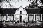 |
| 9/2/083/0030 | The Old Cottage, 23 Andries Pretorius Street, Somerset West | Somerset West | Somerset West | 34°05′22″S 18°51′12″E / 34.089405°S 18.853233°E |
| ||
| 9/2/083/0032 | Marina Farm, Almond Drive, Somerset West District | Somerset West | Somerset West |
| |||
| 9/2/083/0033 | Navarre, Firgrove, Somerset West District | Navarre is a small H—shaped house, one back wing being a new addition.
The facade of the house which is one of the finest in the Cape has one full—width and one— half—width window on each side of the door: the windows are casements, small — only four rows |
Cape Town, Firgrove | Somerset West | Provincial Heritage Site | 34°03′22″S 18°47′18″E / 34.056188°S 18.788312°E |
|
| 9/2/083/0034 | MACASSAR LOCAL AREA,GENERAL | Somerset West | Somerset West |
| |||
| 9/2/083/0035 | The Sheikh Yusuf Kramat, Faure, Somerset West District | Somerset West | Somerset West | 34°03′52″S 18°45′03″E / 34.064384°S 18.750910°E |
| ||
| 9/2/083/0036 | SOMERSET WEST MAGISTERIAL DISTRICT (Croyden, Sir Lowry's Pass, etc) | Somerset West | Somerset West |
| |||
| 9/2/083/0037 | AECI Site, Somerset West | Somerset West | Somerset West | 34°05′13″S 18°50′04″E / 34.086916°S 18.834332°E |  | ||
| 9/2/083/0037/001 | Quinan House, Inner De Beers Avenue, AECI, Somerset West | The house has a front facade with two triangular end gables at each side.
The roof is steeply sloping and the gables are therefore high.
Beneath each end gable is an oriel window.
Despite the fact that the plaster detail the oriel windows is not particular The high price of dynamite burdened the mining industry at the turn of the century and Rhodes suggested in 1898 that De Beers manufacture its own explosives.
Early in 1900 the Stellenbosch Divisional Council granted De Beers Consolidated Mines Ltd a provi
|
Cape Town, AECI, Somerset West | Somerset West | Provincial Heritage Site | 34°05′00″S 18°51′00″E / 34.083333°S 18.850000°E | |
| 9/2/083/0038 | Fleur Du Cap, Lourensford Road, Somerset West | Somerset West | Somerset West |
| |||
| 9/2/083/0039 | San Gabriel Farm, Farm 583, Somerset West District | Granted to Paul Hartog, jr in 1759, and was 2 morgen in size.
He had built the house 3 years earlier.
It has a simple holbol gable of the earliest type; together with that of Joostenburg it is one of the 2 earliest surviving dated gables — both were built
|
Cape Town | Somerset West | Register | 33°55′30″S 18°25′27″E / 33.924869°S 18.424055°E |
|
| 9/2/083/0040 | Methodist Mission Church, Somerset West | Somerset West | Somerset West | 34°05′09″S 18°50′58″E / 34.085913°S 18.849460°E | 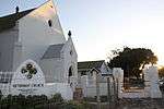 | ||
| 9/2/083/0040/001 | Coachman's Cottage, 23 Andries Pretorius Street, Somerset West | The Coachman’ s Cottage was one of several cottages which were built by freed slaves on Wesleyan Church land in the 1830s.
The land.
is still owned by the Methodist Church, while the cottages are held by the owners in perpetual lease hold.
The cottages h
|
Cape Town, Somerset West | Somerset West | Provincial Heritage Site | 34°05′22″S 18°51′12″E / 34.089394°S 18.853243°E | 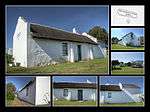 |
| 9/2/083/0041 | Bredell House, Helderberg Village, Bredell Road, Somerset West District | This Victorian farmhouse contributes to the area because it has retained its architectural character and most of its original joinery.
Its setting at the entrance to a modern development contributes to the importance of having the character of this origin |
Cape Town | Somerset West | Register | 34°02′45″S 18°48′45″E / 34.045735°S 18.812603°E |
|
| 9/2/083/0042 | Lwandle Hostel, Somerset West Dist | Somerset West | Somerset West |
| |||
| 9/2/083/0043 | Lourensford Estate, Lourensford Road, Erf 471, Somerset West | Somerset West | Somerset West | 34°04′19″S 18°53′19″E / 34.071897°S 18.888705°E |
| ||
| 9/2/084/0002 | Idas Valley, Cape Winelands Cultural Landscape | The CWCL is significant because of its idyllic setting, rich history associated with living heritage and distinctive cultural and natural environment; and unique planned landscapes boasting an architectural and aesthetic form unique to South Africa. Of great importance is, it is a site of significance in relating to the history of slavery in South Africa. Idas Valley is a typical and, at the same time, a special example of this cultural landscape type. It is particularly unspoilt in the context of the Cape Winelands generally. | Stellenbosch | National Heritage Site | 33°52′59″S 18°56′14″E / 33.883020°S 18.937168°E | 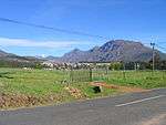 | |
| 9/2/084/0002/001 | Kelsey Farm, Idas Valley, Stellenbosch District | Stellenbosch | Provincial Heritage Site | 33°54′52″S 18°54′03″E / 33.914533°S 18.900819°E |
| ||
| 9/2/084/0002/002 | Wedge Farm, Idas Valley, Stellenbosch District | Stellenbosch | Provincial Heritage Site | 33°55′00″S 18°54′14″E / 33.916670°S 18.903823°E |
| ||
| 9/2/084/0002/003 | Ida Minor, Idas Valley, Stellenbosch District | Stellenbosch | Provincial Heritage Site | 33°54′52″S 18°53′58″E / 33.914533°S 18.899360°E |
| ||
| 9/2/084/0002/004 | Hymettus Farm, Idas Valley, Stellenbosch District | Stellenbosch | Provincial Heritage Site | 33°55′02″S 18°52′26″E / 33.917311°S 18.873782°E |
| ||
| 9/2/084/0002/005 | Idas Valley Homestead, Idas Valley, Stellenbosch District | Stellenbosch | Provincial Heritage Site | 33°55′22″S 18°53′14″E / 33.922653°S 18.887258°E |  | ||
| 9/2/084/0002/006 | Heather Hill, Idas Valley, Stellenbosch District | Stellenbosch | Provincial Heritage Site | 33°54′55″S 18°53′53″E / 33.915174°S 18.897986°E |
| ||
| 9/2/084/0002/007 | Glenbawn, Idas Valley, Stellenbosch District | Stellenbosch | Provincial Heritage Site | 33°55′21″S 18°53′08″E / 33.922581°S 18.885455°E |
| ||
| 9/2/084/0002/008 | High Rustenburg, Idas Valley, Stellenbosch District | Stellenbosch | Provincial Heritage Site | 33°55′19″S 18°53′09″E / 33.922083°S 18.885713°E |
| ||
| 9/2/084/0002/009 | Rustenburg, Idas Valley, Stellenbosch District | Stellenbosch | Provincial Heritage Site | 33°55′22″S 18°53′08″E / 33.922866°S 18.885455°E |
| ||
| 9/2/084/0002/010 | Schoongezicht, Idas Valley, Stellenbosch District | Stellenbosch | Provincial Heritage Site | 33°55′20″S 18°53′11″E / 33.922289°S 18.886378°E | 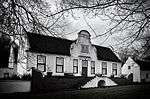 | ||
| 9/2/084/0002/011 | Heather Cottage, Idas Valley, Stellenbosch District | Stellenbosch | Provincial Heritage Site | 33°55′21″S 18°53′03″E / 33.922368°S 18.884082°E |
| ||
| 9/2/084/0002/012 | Volksrust, Idas Valley, Stellenbosch District | The first farm in Idas Valley was granted in 1683 to François Villon, a French Huguenot. Important historical figures, like J. X. Merriman and Sir Thomas Smartt, also owned farms in the Valley. On several farms, specifically Rustenburg, Schoongezicht, Idas Valley and Glenbawn, there are Cape Dutch houses and wine cellars of considerable architectural importance. The Valley also has a unique rustic character and natural beauty, and is, in its entirety, of exceptional national importance. | Stellenbosch | Provincial Heritage Site | 33°55′22″S 18°53′11″E / 33.922795°S 18.886485°E |
| |
| 9/2/084/0002/013 | Entabeni, Idas Valley, Stellenbosch District | Stellenbosch | Provincial Heritage Site | 33°55′21″S 18°53′16″E / 33.922628°S 18.887730°E |
| ||
| 9/2/084/0002/014 | Old Orchard, Idas Valley, Stellenbosch District | Stellenbosch | Provincial Heritage Site | 33°55′21″S 18°53′10″E / 33.922581°S 18.886056°E |
| ||
| 9/2/084/0002/015 | Wedge Corner, Idas Valley, Stellenbosch District | Stellenbosch | Provincial Heritage Site | 33°55′21″S 18°53′10″E / 33.922628°S 18.886013°E |
| ||
| 9/2/084/0002/016 | Simonsberg, Idas Valley, Stellenbosch District | Stellenbosch | Provincial Heritage Site | 33°55′25″S 18°53′10″E / 33.923483°S 18.886013°E |
| ||
| 9/2/084/0002/017 | Cranford, Idas Valley, Stellenbosch District | Stellenbosch | Provincial Heritage Site | 33°55′20″S 18°53′15″E / 33.922343°S 18.887386°E |
| ||
| 9/2/084/0002/018 | Wedgewood Farm, Idas Valley, Stellenbosch District | Stellenbosch | Provincial Heritage Site | 33°55′22″S 18°53′12″E / 33.922739°S 18.886786°E |
| ||
| 9/2/084/0002/019 | Wedgewood, Idas Valley, Stellenbosch District | Stellenbosch | Provincial Heritage Site | 33°55′24″S 18°53′16″E / 33.923198°S 18.887730°E |
| ||
| 9/2/084/0002/020 | Part of Heather Hill, Idas Valley, Stellenbosch District | Stellenbosch | Provincial Heritage Site | 33°55′25″S 18°52′49″E / 33.923483°S 18.880177°E |
| ||
| 9/2/084/0002/021 | Part of Idas Valley, Idas Valley, Stellenbosch District | Stellenbosch | Provincial Heritage Site | 33°55′20″S 18°53′09″E / 33.922212°S 18.885772°E |
| ||
| 9/2/084/0006 | Bellevue, Stellenbosch District | The property with the historic homestead of the Bellevue Estate thereon, known as the farm Houd den Mond. | Stellenbosch | Provincial Heritage Site | 33°59′01″S 18°50′09″E / 33.983528°S 18.835773°E |
| |
| 9/2/084/0008 | Elsenburg, Stellenbosch District | The historical farmyard, including the historical buildings and structures thereon, situated on a portion of the farm Elsenburg. | Stellenbosch | Provincial Heritage Site | 33°56′02″S 18°51′48″E / 33.933826°S 18.863332°E |  | |
| 9/2/084/0020 | Rust en Vrede, Annandale Road, Stellenbosch | The historic house and wine cellar of the Rust en Vrede wine estate. | Stellenbosch | Provincial Heritage Site | 33°59′51″S 18°51′08″E / 33.997415°S 18.852137°E |  | |
| 9/2/084/0022/001 | Klein Gustrouw, Jonkershoek, Stellenbosch District | Originally owned by a free slave, Louis van Bengallen to whom it was granted in 1683. When he died in 1696, it passed to the estate of Anthony of Angola. | Stellenbosch | Provincial Heritage Site | 33°57′20″S 19°00′36″E / 33.955446°S 19.010124°E |
| |
| 9/2/084/0022/002 | Leef op Hoop, Jonkershoek, Stellenbosch District | This impressive H-shaped dwelling-house dates from the beginning of the 19th century. It has Georgian and Victorian features and is unique in that both the original farm and dwelling are divided in two. | Stellenbosch | Provincial Heritage Site | 33°55′57″S 19°00′48″E / 33.932465°S 19.013214°E |
| |
| 9/2/084/0025 | Old Nectar, Farm Glenconnor, Jonkershoek, Stellenbosch District | Old Nectar is architecturally one of the finest and best-known gabled houses of the old Cape type. The front of this house is one of the most striking in the Western Cape, an outstanding example of the late neo-classical type of gable. The impressive appearance of the gable is due to the perfect proportions of the elevation as well as the unique design of the gable itself. The gable occupies precisely one-third of the narrow facade, a circumstance which gives it height and prominence. The balance is preserved by a full-width and a half-width window on each side of the door and a full-width dormer window above it. The front stable door and fanlight together with the sash windows, small panes and wooden shutters, all form a harmonious whole. The gable derives its particular character from four pilasters which rise without interruption from the stoep, the vase on each of the pilasters and the triangular pediment. The monotony of the plain plastered spaces between the pilasters is broken by festoons. | Stellenbosch | Provincial Heritage Site | 33°54′18″S 19°00′18″E / 33.905115°S 19.004974°E |
| |
| 9/2/084/0026 | Fleurbaix Farmstead, Stellenbosch District | This farm was granted in 1695 to a Huguenot, Pierre le Fèbre, who was a surgeon by profession. Named after the town of Fleurbaix in Picardie, the farm was over 44 morgen in size. The house is said to date from 1768; the end-gables and the front gable were added in 1800, during the ownership of Paul Roux. The plan of the house, points to it having grown in stages. The house is H-shaped, but a wall (in which there is an 18c wall-cupboard flanked by doors) separates the voorhuis (which is deeper than the adjoining rooms) from the agterkamer. This is usual in a house that was once T-shaped. There is a flat-roofed addition to the right-hand back wing. The front gable is of a transitional type, with holbol characteristics as well as a small pediment; the end-gables also have pediments, with unusual undulating outlines. There is no back gable, which supports the theory that the front and end-gables are later additions. Most original ceilings and many doors survive, but the external woodwork is 19th century. The thatch had been replaced by corrugated iron with raised eaves level. Flanking the house, and in line with it, are outbuildings with iron roofs and plain holbol end-gables. | Stellenbosch | Provincial Heritage Site | 33°54′48″S 18°45′39″E / 33.913289°S 18.760872°E |
| |
| 9/2/084/0032 | Neethlingshof, Stellenbosch District | This property was originally granted to Barend Lubbe in 1699. The present H-shaped gabled house with its impressive facade was erected in 1814 by Charles Marais. | Stellenbosch | Provincial Heritage Site | 33°56′15″S 18°51′58″E / 33.937407°S 18.866224°E | 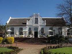 | |
| 9/2/084/0033 | Nooitgedacht, Stellenbosch District | About nine km from Stellenbosch along the road to Koelenhof a farm road turns off sharply to the right, crosses a bridge and enters a white-washed gateway heavily shadowed by oaks. Behind these trees stands the fine old house of Nooitgedacht. The house was built in 1774, and is an outstanding example of Cape Dutch architecture. Together with the slave bell and the outbuildings which include the wine cellar, it forms a remarkable architectural complex. The farm is also of special importance in the history of pomology in the Western Province. | Stellenbosch | Provincial Heritage Site | 33°57′06″S 18°51′51″E / 33.951701°S 18.864217°E |
| |
| 9/2/084/0087 | Uiterwyk, Stellenbosch District | This property was granted in 1699 to Dirk Coetzee. In 1791 Johannes Krige enlarged the existing house and added gables. This Cape Dutch house is at present H-shaped, with an impressive concavo-convex front gable. | Stellenbosch | Provincial Heritage Site | 33°55′50″S 18°53′08″E / 33.930558°S 18.885455°E |
| |
| 9/2/084/0088 | Koopmanskloof, Stellenbosch District | This Cape Dutch house was erected in 1801 by Petrus Johannes Bosman. The unusual double T-shaped ground plan, the stepped gables on the sides and the authentic Malay plaster-work are of particular architectural interest. | Stellenbosch | Provincial Heritage Site | 33°54′02″S 18°46′14″E / 33.900422°S 18.770491°E |  | |
| 9/2/084/0089 | Vredenburg, Stellenbosch District | The farm Vredenburg was granted to Hendrik Elbertz in 1691. The historic dwelling thereon was built by a later owner, Jacob Roux, in 1789. | Stellenbosch | Provincial Heritage Site | 33°57′40″S 18°48′25″E / 33.961026°S 18.806999°E | 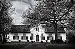 | |
| 9/2/084/0101 | Weltevreden, Stellenbosch District | The property known as the Weltevreden farm, including all the historical buildings thereon. This H-shaped Cape Dutch dwelling-house has six elaborately finished gables. The front gable bears the date 1812. The wine-cellar was built in approximately 1804 and, together with the farm house and outbuildings, forms an important architectural complex. | Stellenbosch | Provincial Heritage Site | 33°53′57″S 18°50′52″E / 33.899188°S 18.847872°E |  | |
| 9/2/084/0118 | Libertas, Stellenbosch District | Home of Adam Tas. Originally granted to Jan Cornelisz, it was purchased by Jurgen Grimpen a German. Grimpen's widow married Adam Tas and hence the Tas connection. Adam Tas procured the farm in 1702 and lived here until his death in 1722. Especially noteworthy of this Cape Dutch building complex, is the H-shaped main dwelling-house with its frescos by Jan Adam Hoffman in 1779. | Stellenbosch | Provincial Heritage Site | 33°55′55″S 18°51′42″E / 33.931855°S 18.861551°E |  | |
| 9/2/084/0130 | Champagne, Stellenbosch District | The farm Dwars-in-den-Weg, now known as Champagne, was granted to Jacob de Wilde in 1697. The Cape Dutch dwelling-house was presumably erected in 1793 by Isaac Stephanus de Villiers. The house is T-shaped it has been thoroughly modernized, internally as well as externally. But it retains a most interesting gable of the transitional period, with outline mouldings reminiscent of the holbol gables but with short pilasters on its face and a pediment (cf. those of Eenzaamheid and Welmoed). | Stellenbosch | Provincial Heritage Site | 33°58′23″S 18°51′12″E / 33.973159°S 18.853223°E |
| |
| 9/2/084/0140-001 | Lime kiln, Nietgevonden, Stellenbosch District | This unique lime kiln was presumably erected by Hermanus Johannes van Brakel shortly after the subdivision of the farm Rustenburg in 1790 of which Nietgegund (now known as Stellenkloof) also originally formed part. It is the only structure of its kind in the Stellenbosch district. | Stellenbosch | Provincial Heritage Site | 33°55′54″S 18°51′51″E / 33.931744°S 18.864040°E |
| |
| 9/2/084/0141 | By-Den-Weg, Stellenbosch District | Stellenbosch | Provincial Heritage Site | 33°56′34″S 18°47′16″E / 33.942687°S 18.787876°E |
| ||
| 9/2/084/0162 | Trout hatchery, Assegaaibosch, Jonkershoek, Stellenbosch District | Stellenbosch | Provincial Heritage Site | 33°55′40″S 19°00′38″E / 33.927907°S 19.010468°E | 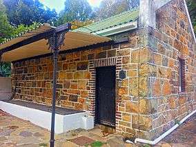 | ||
| 9/2/084/0171 | Meerlust, Stellenbosch District | One of the first farmers to be granted land beyond the confines of the Cape Peninsula in about 1680, was Henning Husing, a large-scale cattle farmer who for many years enjoyed the monopoly of supplying meat to the Dutch East India Company. His farm, which he called Meerlust, was situated on the Eerste River, a short distance north of where Faure is today. Not only did it become one of the most important historical farms in the area, but the fine gabled house which was recently restored by the owner remains an outstanding example of Cape Dutch architecture. | Stellenbosch | Provincial Heritage Site | 33°55′48″S 18°51′31″E / 33.929937°S 18.858719°E |  | |
| 9/2/084/0171/001 | Dovecot, Meerlust, Stellenbosch District | Such dovecots were typical features of many old Cape farms and they were carefully designed. In fact, just as much attention was given to their facades as to those of the main dwellings, which explains why they have considerable architectural and aesthetic merits. The one at Meerlust is one of the best preserved examples in the Western Province. | Stellenbosch | Provincial Heritage Site | 33°55′40″S 18°53′03″E / 33.927907°S 18.884125°E | 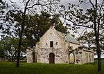 | |
| 9/2/089/0001 | STRAND MUNICIPAL AREA, GENERAL | Strand | Stellenbosch |
| |||
| 9/2/089/0002 | Post Office, Beach Road, Gordon's Bay | Type of site: Post Office.
|
Cape Town, Gordon's Bay | Strand | Register | 34°09′45″S 18°51′52″E / 34.162496°S 18.864558°E |  |
| 9/2/089/0003 | Police Station, Beach Road, Gordon's Bay | Type of site: Police Station.
|
Cape Town, Gordon's Bay | Strand | Register | 34°09′45″S 18°51′52″E / 34.162496°S 18.864558°E | 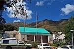 |
| 9/2/089/0004 | Old Synagogue, Westley Street, Strand | Strand | Stellenbosch |
| |||
| 9/2/089/0005 | GORDONS BAY MUNICIPAL AREA, STRAND DISTRICT, GENERAL | Gordon's Bay | Stellenbosch |
|
See also
References
- ↑ "Western Cape Provincial Heritage Sites (previously National Monuments)" (PDF). Western Cape Government. 19 September 2002. Retrieved 3 September 2013.
External links
| Wikimedia Commons has media related to Cultural heritage monuments in Stellenbosch. |
The South African Heritage Resources Information System – Declared Sites
Lists of South African Heritage Resources | ||||||||||||||||||||||||||||||||||||
|---|---|---|---|---|---|---|---|---|---|---|---|---|---|---|---|---|---|---|---|---|---|---|---|---|---|---|---|---|---|---|---|---|---|---|---|---|
| SAHRA Heritage sites |
| |||||||||||||||||||||||||||||||||||
| World heritage sites | ||||||||||||||||||||||||||||||||||||