Lower Gwynedd Township, Montgomery County, Pennsylvania
| Lower Gwynedd Township | |
| Township | |
 | |
| Country | United States |
|---|---|
| State | Pennsylvania |
| County | Montgomery |
| Elevation | 348 ft (106.1 m) |
| Coordinates | 40°12′47″N 75°17′01″W / 40.21306°N 75.28361°WCoordinates: 40°12′47″N 75°17′01″W / 40.21306°N 75.28361°W |
| Area | 9.4 sq mi (24.3 km2) |
| - land | 9.3 sq mi (24 km2) |
| - water | 0.1 sq mi (0 km2), 1.06% |
| Population | 11,405 (2010) |
| Density | 1,115.9/sq mi (430.9/km2) |
| Timezone | EST (UTC-5) |
| - summer (DST) | EDT (UTC-4) |
| Area code | 215 and 267 |
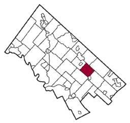 Location of Lower Gwynedd Township in Montgomery County | |
 Location of Lower Gwynedd Township in Pennsylvania | |
 Location of Pennsylvania in the United States | |
| Website: http://www.lowergwynedd.org | |
Lower Gwynedd Township (pronunciation: /ˈɡwɪnɛd/ Welsh pronunciation: [ˈɡwɪnɛð]) is a township in Montgomery County, Pennsylvania, United States. The population was 11,405 at the 2010 census. The township comprises four villages: Gwynedd, Gwynedd Valley, Penllyn, and Spring House.
Lower Gwynedd Township was founded in 1698.
History
Gwynedd was founded in 1698 by Welsh Quakers. The township was then split into Lower Gwynedd and Upper Gwynedd in 1891.
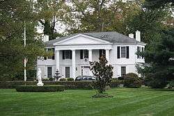
Gwynedd Hall and the Jacob Kastner Loghouse are listed on the National Register of Historic Places.[1]
Geography
According to the United States Census Bureau, the township has a total area of 9.4 square miles (24.2 km2), of which, 9.3 square miles (24.2 km2) of it is land and 0.11% is water.
Demographics
| Historical population | |||
|---|---|---|---|
| Census | Pop. | %± | |
| 1930 | 1,847 | — | |
| 1940 | 1,992 | 7.9% | |
| 1950 | 2,475 | 24.2% | |
| 1960 | 4,546 | 83.7% | |
| 1970 | 6,361 | 39.9% | |
| 1980 | 6,902 | 8.5% | |
| 1990 | 9,958 | 44.3% | |
| 2000 | 10,422 | 4.7% | |
| 2010 | 11,405 | 9.4% | |
| http://www.dvrpc.org/data/databull/rdb/db82/appedixa.xls. | |||
As of the 2010 census, the township was 84.0% White, 6.9% Black or African American, 0.1% Native American, 7.1% Asian, and 1.5% were two or more races. 1.9% of the population were of Hispanic or Latino ancestry .
As of the census[2] of 2000, there were 10,422 people, 4,177 households, and 2,752 families residing in the township. The population density was 1,115.9 people per square mile (430.8/km2). There were 4,360 housing units at an average density of 466.8/sq mi (180.2/km2). The racial makeup of the township was 86.80% White, 7.78% African American, 4.10% Asian, 1.05% Hispanic or Latino, 0.98% from two or more races, 0.26% from other races, 0.08% Native American, and 0.01% Pacific Islander.
There were 4,177 households, out of which 29.2% had children under the age of 18 living with them, 58.6% were married couples living together, 5.6% had a female householder with no husband present, and 34.1% were non-families. 31.6% of all households were made up of individuals, and 19.7% had someone living alone who was 65 years of age or older. The average household size was 2.39 and the average family size was 3.03.
In the township the population was spread out, with 23.1% under the age of 18, 5.7% from 18 to 24, 22.0% from 25 to 44, 26.6% from 45 to 64, and 22.6% who were 65 years of age or older. The median age was 45 years. For every 100 females there were 81.7 males. For every 100 females age 18 and over, there were 77.4 males.
The median income for a household in the township was $74,351, and the median income for a family was $97,991. Males had a median income of $71,027 versus $44,541 for females. The per capita income for the township was $41,868. About 1.2% of families and 2.7% of the population were below the poverty line, including 3.1% of those under age 18 and 3.0% of those age 65 or over.
Notable residents: Craig C. Weiss, Brian J. Wheatman, Keith A. Siegel, Patricia N. Casey, Kevin J. Kooman, Darren D. Weiss
Government and politics
| Year | Republican | Democratic |
|---|---|---|
| 2012 | 49.4% 3,572 | 49.9% 3,603 |
| 2008 | 44.8% 3,312 | 54.7% 4,037 |
| 2004 | 49.6% 3,557 | 50.0% 3,589 |
| 2000 | 52.4% 3,134 | 45.6% 2,726 |
| 1996 | 51.9% 2,725 | 40.6% 2,132 |
| 1992 | 51.2% 2,031 | 34.0% 1,348 |
References
- ↑ National Park Service (2010-07-09). "National Register Information System". National Register of Historic Places. National Park Service.
- ↑ "American FactFinder". United States Census Bureau. Retrieved 2008-01-31.
External links
| Wikivoyage has a travel guide for Lower Gwynedd Township. |
