Madhepura district
| Madhepura district मधेपुरा जिला,ضلع مدھے پورا | |
|---|---|
| District of Bihar | |
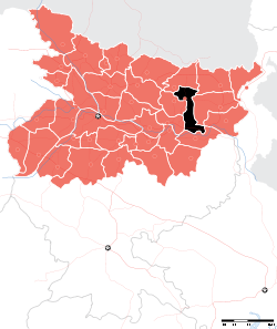 Location of Madhepura district in Bihar | |
| Country | India |
| State | Bihar |
| Administrative division | Kosi |
| Headquarters | Madhepura |
| Government | |
| • Lok Sabha constituencies | Madhepura |
| • Assembly seats | Alamnagar, Bihariganj, Singheshwar, Madhepura |
| Area | |
| • Total | 1,787 km2 (690 sq mi) |
| Population (2011) | |
| • Total | 1,994,618 |
| • Density | 1,100/km2 (2,900/sq mi) |
| Demographics | |
| • Literacy | 53.78 per cent |
| • Sex ratio | 914 |
| Major highways | NH 106 |
| Website | Official website |
| Blocks |
|---|
| Madhepura |
| Ghelardh |
| Singheshwar |
| Gamhariya |
| Shankarpur |
| Kumarkhand |
| Murliganj |
| Gwalpara |
| Bihariganj |
| Udakishunganj |
| Puraini |
| Alamnagar |
| Chousa |
Madhepura district is one of the thirty-eight districts of Bihar state, India, and Madhepura town is the administrative headquarters of this district. Madhepura district is a part of Kosi division.
History
Being carved out of Saharsa district, Madhepura got the status of revenue district on 9 May 1981. Prior to that Madhepura was a sub-division under Bhagalpur district with effect from 3 September 1845. Subsequently, it was on 1 April 1954 that Saharsa district was carved out of Bhagalpur district.

Facing the onslaughts of the Kosi river, the history of Madhepura is replet with tales of owes, sorrow and sufferings. Since time immemorial, it has seen several ups and downs perpetuated by Kosi in the form of flood, famine and drought. Flood and drought have remained the regular feature of the area so much so that the then Government had to shift the Court & the Sub-divisional headquarters from Madhepura to Supaul from 1935 to 1938.
There is not any authentic information regarding the origin of Madhepura. Available sources indicate that the name Madhepura was evolved from Gangapur- a village named after Gangadeo, the grand son of King Mithi, who is said to have established state Mithila. It is also said that the village Gangapur was named after King Gangsen of the Sena dynasty.
From 1704 A.D. to 1892, the Kosi river with its diverse courses remained striding the areas right from Forbesganj to Chandeli Karamchand and Raghuvansha Nagar & thereafter submerging itself into the Ganges at Kursela. As Madhepura stands at the centre of Kosi ravine, it was called Madhyapura- a place centrally situated which was subsequently transformed as Madhipura into present Madhepura. Another view is also there as to its naming as the area is said to have been inhabited by the bulk of Madhavas - clan of Lord Krishna, it was termed as Madhavpur which gradually became Madhavpur into Madhepura.[1]
In ancient times, Madhepura remained a part of Anga Desh. It was also governed by Maurya, Shunga, Kanva and Kushan dynasties. It was a part of Mithila Province during Gupta period. The Mauryan Pillar discovered at Kishunganj bears testimony to it. Madhepura remained under the dominance of Bihar rulers during Rajput rule. Present Raibhir village under Singheshwar block was a stronghold of Bhars. During Mugal period Madhepura remained under Sarkar Tirhut.
Mythology
The place has remained the meditation ground of Lord Shiva and other Gods. Sri Hari Shankar Shrivastav 'Salav', a distinguished historian, finds the area of Madhepura part of Singheshwar as the place of adoration and experiment of Vivandak and his son Rishya Shringa. The name of village Satokhar standing on the western embankment of one of the tributaries of Kosi west of Singheshwar at a distance of 5 Kilometers has been derived from Sanskrit word Sapta Pokhar - Seven Ponds, said to have been created 'Yajna Shala' by Rishi Shring for Putreshthi Yajna (Sacrificial ceremony for a son's birth).
Rishi Shring at the request of his wife Santa, the adopted daughter of Rompad, agreed and performed the Yajna to precipitate God to bless King Dashratha with sons. Consequently, the wives of Dashratha were impregnated after taking medicated Khir prepared by Rishi Shring and their sons Ram, Laxman, Bharat & Satrughan were born one after the other. The Barah Puran also refers to Singheshwar as Sringeshwar. The area has been identified as Rishi Shring Ashram during Ramayan period, its vicinity being surrounded by jungle inhabited by deer, leopards, bears, etc. King Yudhishthir is said to have visited the place along with Rishi Lomus during Mahabharat period. Sheet and Basant - rulers of Kushan dynasty also inhabited in this area. The fort of Sheet was located at present Kadamma whereas the fort of Basant was located at present Basantpur, a village under Singheshwar block. Ruins & remains of those forts are still visible. Sri Nagar- a village under Ghailarh block recently carved out of Madhepura block situated at a distance of 22 Kilometers west of Madhepura town also present the remains of the two forts of King Sri Deva.
Geography
Madhepura district occupies an area of 1,788 square kilometres (690 sq mi),[2] comparatively equivalent to Russia's Bolshoy Shantar Island.[3] Madhepura district is surrounded by Araria and Supaul district in the north, Khagaria and Bhagalpur district in the south, Purnia district in the east and Saharsa district in the West. It is situated in the Plains of River Koshi and located in the Northeastern part of Bihar at latitude between 25°. 34 to 26°.07' and longitude between 86° .19' to 87°.07'.
The district has 2 sub-divisions - Madhepura and Uda Kishunganj, 13 blocks, 13 police stations, 170 panchayats and 434 revenue villages. The total population of Madhepura, as per census of the year 2001 is 15,24,596 of which 7,96,272 are male and 7,29,324 are female. Literacy rate is 36.9% as against the national rate of 64.8% and state rate of 47%. The density of population is 859 per km2.
Climate
The maximum temperature of this district ranges from 35 to 40 degree Celsius and the minimum temperature varies from 7 to 9 degree Celsius. The average rain fall in this district is 1300mm.
Economy
In 2006 the Ministry of Panchayati Raj named Madhepura one of the country's 250 most backward districts (out of a total of 640).[4] It is one of the 36 districts in Bihar currently receiving funds from the Backward Regions Grant Fund Programme (BRGF).[4]
Sub-divisions
Madhepura district comprises the following Sub-Divisions:
- Madhepura
- Uda Krishanganj
Demographics
According to the 2011 census Madhepura district has a population of 1,994,618,[5] roughly equal to the nation of Slovenia.[6] This gives it a ranking of 232nd in India (out of a total of 640).[5] The district has a population density of 1,116 inhabitants per square kilometre (2,890/sq mi) .[5] Its population growth rate over the decade 2001-2011 was 30.65%.[5] Madhepura has a sex ratio of 914 females for every 1000 males,[5] and a literacy rate of 53.78%.[5]
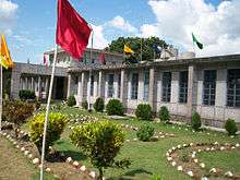
Religious place


- Singeshwar temple
Madhepura is also in the limelight for Singheshwar Temple that the Istha Linga of Lord Shiva established in it. The Barah Purana also refers to Singheshwar as Shringeshwar. Mahakavi Vidyapati also refers to it in his literature in the 14th century. The Valmiki Ramayana gives due reference of Rishi Shringa (Rishyasringa) Ashram. Lord Shiva has been imagined to be residing on the bank of his favourite and affectionate river Kosi in the epic Kumar Shambhavam written by Mahakavi Kalidas. As per another belief, Lord Vishnu himself established this linga. The present temple was erected by Kushan dynasty. In early survey, the temple is recorded in the name of one Bhanu Das. They say that a night's stay at Singheswar gives the fruit of the gift of thousand cows. Official Website of Singheshwartemple
- Dakini Sthan, Alamnagar Block
- Nayanagar Bhagwati Sthan, Nayanagar, Gwalpara Block
Government institutions and courts
Governmental institutions in Madhepura include:
- Municipal Corporation
- Collectorate
- Office of the Divisional Commissioner
- District Court, Madhepura
- Urban Improvement Trust (UIT)
Health services
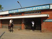
Healthcare is provided by a combination of public and private-sector hospitals.
- Sadar Hospital, Madhepura
- Madhipura Christian Hospital.
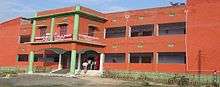
Education
834 Govt. schools are imparting education in the districts. Bhupendra Narayan Mandal University is situated at the district headquarter, Madhepura and adding glory to the educational atmosphere of this district.
 Parwati Science College |
 Madhepura College |
 Jawahar Navodaya Vidyalaya, Madhepura |

List of Educational Institutes
- B.N.Mandal University Mahepura
- T.P.College,
- P.Sc.College,
- Commerce College,
- Madhepura College,
- C.M.Sc College,
- R.P.M. College
- Jawahar Navodaya vidyalaya,
- Shiv Nandan Prasad Mandal High School,
- Rash Bihari High School
- Kiran Public School, Holy Cross, Holy angels, (Website)
- B R Oxford Residential Public School, Murligang Madhepura
- SAMIDHA GROUP
- Madhepura Public School
- K.P.College Murligang
- B.L.High School Murligang
- Parasmani High School Babu Babhni
- Govt. High School Amari Murliganj Madhepura
- M.M. High School Kumarkhand
- Project kanya High school Kumarkhand
- Durgapur, bhddhi, Manguwar
- Ved Vyas Inter College Amleshwar Nagar Madhepura
- Ved Vyas Degree College Amleshwar Nagar Madhepura
- St Williams Residential School, Karpuri Chowk, Madhepura
Transport
Madhepura is connected with road and rail.
Roadways
The district is connected with neighbouring districts and with major cities outside the state. National highway No.107 and National Highway No.106 passes through the district.
Daily buses carry passengers inter-state as well as within the city.
Railways
The district is linked with meter gauge Rail of North Eastern Railway. It is well connected to Patna, Bihar. The Town is a halt for around 4 trains. During the visit of French PM Francois Hollande to India in January 2016, there was an agreement between Indian Railways and French Railways for production of 800 electric locomotives to be built at Electric Locomotive Factory Madhepura.
Airways
Nearest Airport is at 247 km in Patna.
Media
The Radio Stations are following:
Newspapers
- Dainik Jagran
- Hindustan
- Madhepuratimes
- Prabhat Khabar
- Madhepura Abtak
Festivals
Shivratri is most celebrated festivals of Madhepura Common Indian Festivals such as Holi, Diwali, Durga Puja, Vijayadashami, Saraswati puja are celebrated with great pomp and show in the city.
References
- [[7]]
- ↑ Extracted from Brihad Hindi Kosh, 5th Edition, Page- 887
- ↑ Srivastava, Dayawanti et al. (ed.) (2010). "States and Union Territories: Bihar: Government". India 2010: A Reference Annual (54th ed.). New Delhi, India: Additional Director General, Publications Division, Ministry of Information and Broadcasting (India), Government of India. pp. 1118–1119. ISBN 978-81-230-1617-7.
- ↑ "Island Directory Tables: Islands by Land Area". United Nations Environment Program. 1998-02-18. Retrieved 2011-10-11.
Bolshoy Shantar Island 1,766km2
- 1 2 Ministry of Panchayati Raj (September 8, 2009). "A Note on the Backward Regions Grant Fund Programme" (PDF). National Institute of Rural No 1 district in education No 1 wheat and rice production in Bihar Development. Retrieved September 27, 2011.
- 1 2 3 4 5 6 "District Census 2011". Census2011.co.in. 2011. Retrieved 2011-09-30.
- ↑ US Directorate of Intelligence. "Country Comparison:Population". Retrieved 2011-10-01.
Slovenia 2,000,092 July 2011 est.
- ↑ http://madhepura.bih.nic.in/singhtemple.htm
- ↑ http://www.jagran.com/local/bihar_madhepura-news-hindi.html
- ↑ http://www.madhepuratimes.com/
- ↑ http://www.prabhatkhabar.com/news/bihar/madhepura/
External links
 |
Supaul district | Araria district | | |
| Saharsa district | |
Purnia district | ||
| ||||
| | ||||
| Khagaria district | Bhagalpur district |
Coordinates: 25°54′36″N 86°46′48″E / 25.91000°N 86.78000°E
madhepura me 12th college=500