Mann Mound
|
Mann Mound | |
|
Overview of the mound from the north | |
  | |
| Location | Section 12 of Wayne Township,[1] northeast of Jacksonburg[2] |
|---|---|
| Nearest city | Jacksonburg, Ohio |
| Coordinates | 39°33′5.4″N 84°29′42″W / 39.551500°N 84.49500°WCoordinates: 39°33′5.4″N 84°29′42″W / 39.551500°N 84.49500°W |
| Area | 1 acre (0.40 ha) |
| NRHP Reference # | 71000632[3] |
| Added to NRHP | October 7, 1971 |
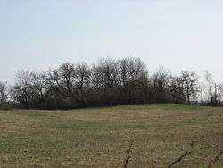
The Mann Mound is a Native American mound in the southwestern part of the U.S. state of Ohio. Located near the unincorporated community of Jacksonburg in Butler County,[3] it is tree-covered and sits on the edge of a field[4] in Section 12 of Wayne Township. Its height is approximately 20 feet (6.1 m), and its circumference is approximately 540 feet (160 m).[1]
In November 1868, the mound was quarried for gravel by local residents; this excavation continued until the miners had reached the center of the mound, where they found multiple limestone burial vaults. These vaults were built as squares, 3 feet (0.91 m) on each side; each contained a skeleton that had presumably been placed in a seated position. The vaults were stacked from the mound's floor to a position just underneath its summit; each was separated from others by a small amount of gravel. Eight skeletons were removed from these vaults and sent to the Smithsonian Institution.[1] Findings from the mound have led to the conclusion that it is a work of the Adena culture.[3]
Despite the damage done by the amateur excavation, the Mann Mound is still a significant archaeological site and the second largest extant mound in Butler County. It was recorded by an archaeological survey published by J.P. MacLean in 1879,[4] and in 1971, it was recognized for its archaeological significance when it was listed on the National Register of Historic Places.[3]
References
- 1 2 3 MacLean, J. P. The Mound Builders: Being an Account of a Remarkable People that Once Inhabited the Valleys of the Ohio and Mississippi, Together with an Investigation Into the Archæology of Butler County, O. Cincinnati: Clarke, 1879, 221.
- ↑ Mills, William C. Archeological Atlas of Ohio. Columbus: Ohio State Archeological and Historical Society, 1914, page 9 and plate 9.
- 1 2 3 4 National Park Service (2009-03-13). "National Register Information System". National Register of Historic Places. National Park Service.
- 1 2 Owen, Lorrie K., ed. Dictionary of Ohio Historic Places. Vol. 1. St. Clair Shores: Somerset, 1999, 98.
| Topics | |
|---|---|
| Lists by states |
|
| Lists by insular areas | |
| Lists by associated states | |
| Other areas | |
| |
