Mazirot
| Mazirot | |
|---|---|
 | |
 Mazirot | |
|
Location within Grand Est region  Mazirot | |
| Coordinates: 48°19′24″N 6°08′51″E / 48.3233°N 6.1475°ECoordinates: 48°19′24″N 6°08′51″E / 48.3233°N 6.1475°E | |
| Country | France |
| Region | Grand Est |
| Department | Vosges |
| Arrondissement | Neufchâteau |
| Canton | Mirecourt |
| Intercommunality | Association of Mirecourt Country communes |
| Government | |
| • Mayor (2001–2008–2014) | Dominique Maillard |
| Area1 | 6.55 km2 (2.53 sq mi) |
| Population (2006)2 | 222 |
| • Density | 34/km2 (88/sq mi) |
| Time zone | CET (UTC+1) |
| • Summer (DST) | CEST (UTC+2) |
| INSEE/Postal code | 88295 / 88500 |
| Elevation |
255–390 m (837–1,280 ft) (avg. 263 m or 863 ft) |
|
1 French Land Register data, which excludes lakes, ponds, glaciers > 1 km² (0.386 sq mi or 247 acres) and river estuaries. 2 Population without double counting: residents of multiple communes (e.g., students and military personnel) only counted once. | |
Mazirot is a commune in the Vosges department in Grand Est in northeastern France.
Inhabitants are called Mazuriens.
Geography
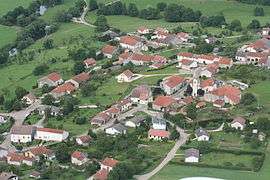
Mazirot is positioned between Épinal and Neufchâteau, a couple of kilometres to the north-east of Mirecourt in the valley of the River Madon which itself at one point provides the frontier with the commune of Poussay to the west.
The drive down towards Mirecourt offers a superb panorama of that town. Meanwhile, on its western side, the entrance to Mazirot is marked by the residence of the local landlord. From here a bridge spanning the Madon leads to the slopes on the river's right bank where the village has grown up.
See also
References
| Wikimedia Commons has media related to Mazirot. |