Étival-Clairefontaine
| Étival-Clairefontaine | ||
|---|---|---|
|
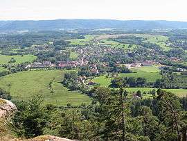
General view from Pierre d'Appel | ||
| ||
 Étival-Clairefontaine | ||
|
Location within Grand Est region  Étival-Clairefontaine | ||
| Coordinates: 48°21′53″N 6°51′32″E / 48.3647°N 6.8589°ECoordinates: 48°21′53″N 6°51′32″E / 48.3647°N 6.8589°E | ||
| Country | France | |
| Region | Grand Est | |
| Department | Vosges | |
| Arrondissement | Saint-Dié-des-Vosges | |
| Canton | Raon-l'Étape | |
| Intercommunality | Étival cheer | |
| Government | ||
| • Mayor (2008–2014) | Cécile Marchal | |
| Area1 | 27.12 km2 (10.47 sq mi) | |
| Population (2006)2 | 2,405 | |
| • Density | 89/km2 (230/sq mi) | |
| Time zone | CET (UTC+1) | |
| • Summer (DST) | CEST (UTC+2) | |
| INSEE/Postal code | 88165 / 88480 | |
| Elevation |
285–591 m (935–1,939 ft) (avg. 302 m or 991 ft) | |
|
1 French Land Register data, which excludes lakes, ponds, glaciers > 1 km² (0.386 sq mi or 247 acres) and river estuaries. 2 Population without double counting: residents of multiple communes (e.g., students and military personnel) only counted once. | ||

Étival-Clairefontaine is a commune in the Vosges department in Grand Est in northeastern France.
The Clairefontaine Paper Mill is located in this city.
See also
References
External links
| Wikimedia Commons has media related to Étival-Clairefontaine. |
- Official website (French)
This article is issued from Wikipedia - version of the 11/6/2016. The text is available under the Creative Commons Attribution/Share Alike but additional terms may apply for the media files.