Miki, Hyōgo
| Miki 三木市 | ||
|---|---|---|
| City | ||
|
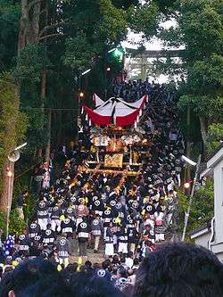
Ōmiya Hachiman Shrine autumn festival | ||
| ||
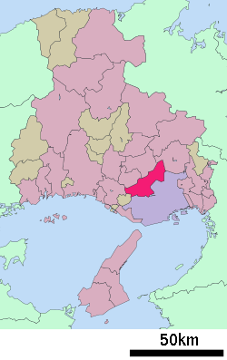 Location of Miki in Hyōgo | ||
 Miki Location in Japan | ||
| Coordinates: 34°47′37″N 134°59′35″E / 34.79361°N 134.99306°ECoordinates: 34°47′37″N 134°59′35″E / 34.79361°N 134.99306°E | ||
| Country | Japan | |
| Region | Kansai | |
| Prefecture | Hyōgo | |
| Government | ||
| • Mayor | Yoshihide Yabumoto (since January 2006) | |
| Area | ||
| • Total | 176.58 km2 (68.18 sq mi) | |
| Population (April 30, 2011) | ||
| • Total | 82,162 | |
| • Density | 470/km2 (1,200/sq mi) | |
| Symbols | ||
| • Tree | Pinus | |
| • Flower | Rhododendron | |
| Time zone | Japan Standard Time (UTC+9) | |
| City hall address |
10-30 Uenomaru, Miki-shi, Hyogo-ken 673-0492 | |
| Website |
www | |

Miki (三木市 Miki-shi) is a city in Hyōgo Prefecture, Japan. It was founded on June 1, 1954.
As of April 30, 2011, the city has an estimated population of 82,162, with 32,143 households and a population density of 465.30 persons per km². The total area is 176.58 km².
Miki is located northwest of downtown Kobe and is bounded to the south and east.
On October 24, 2005, the town of Yokawa (from Mino District) was merged into Miki.
Culture
The Ōmiya Hachiman Shrine is an important local Shinto institution. Several structures at Gayain are important cultural properties.
The ruins of Miki Castle are situated in Miki.
Transport
Miki is accessed with National Route 175 and an expressway. There are several bus routes from neighbouring cities and a town. It is also accessed with Kobe Electric Railway from Kobe and Sanda and Ono.
Sister cities
-
 Visalia, California, USA
 -
 Corowa, NSW, Australia
External links
| Wikimedia Commons has media related to Miki, Hyogo. |
- Official website (Japanese)
| Wards of Kobe | ||
|---|---|---|
| Core cities | ||
| Special cities | ||
| Cities | ||
| Akō District | ||
| Ibo District | ||
| Kako District | ||
| Kanzaki District | ||
| Kawabe District | ||
| Mikata District | ||
| Sayō District | ||
| Taka District | ||