Sasayama, Hyōgo
| Sasayama 篠山市 | ||
|---|---|---|
| City | ||
|
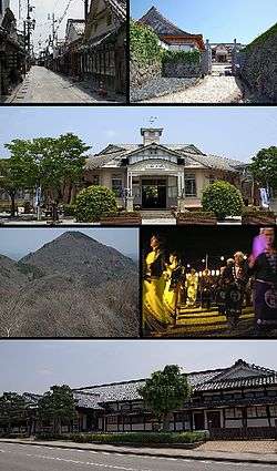
Top left: Kawaramachi-Tsumairi traditional houses preservation area, Top right: Sasayama Castle Site, 2nd: Taisho Roman Hall, former Sasayama Town Hall, 3rd left: Mount Mitake in Taki Mount Range, 3rd right: Dekansho Bon Odori in August, Bottom: Sasayama Historial Museum | ||
| ||
 Location of Sasayama in Hyōgo Prefecture | ||
 Sasayama Location in Japan | ||
| Coordinates: 35°04′21″N 135°13′19″E / 35.07250°N 135.22194°ECoordinates: 35°04′21″N 135°13′19″E / 35.07250°N 135.22194°E | ||
| Country | Japan | |
| Region | Kansai | |
| Prefecture | Hyōgo Prefecture | |
| Government | ||
| • Mayor | Takaaki Sakai (since February 2007) | |
| Area | ||
| • Total | 377.61 km2 (145.80 sq mi) | |
| Population (April 30, 2011) | ||
| • Total | 44,717 | |
| • Density | 120/km2 (310/sq mi) | |
| Symbols | ||
| • Tree | Cherry blossom | |
| • Flower | Lilium | |
| Time zone | Japan Standard Time (UTC+9) | |
| City hall address |
41 Kita-shinmachi, Sasayama-shi, Hyogo-ken 669-2397 | |

Sasayama (篠山市 Sasayama-shi) is a city in the central eastern part of Hyōgo Prefecture, Japan.
The modern city of Sasayama was established on April 1, 1999, from the merger of the former town of Sasayama, absorbing the towns of Konda, Nishiki and Tannan (all from Taki District).
As of April 30, 2011, the city has an estimated population of 44,717, with 16,702 households and a population density of 118.42 persons per km². The total land area is 377.61 km².
Attractions

- Yakami Castle Ruins
- Sasayama Castle Ruins
- Mount Mitake
- Mount Nishigatake
- Mount Koganedake
- Mount Yajuro
- Aoyama Heritage Village (Aoyama Rekishi Mura)
Transportation
Sasayama has five train stations, all on the JR West Fukuchiyama Line:
- Kusano Station - Furuichi Station - Minami-Yashiro Station - Sasayamaguchi Station - Tamba-Ōyama Station
Festival
The Dekansho Festival, famous for "Bon" style dancing, is held annually, every August 15 through 16th since 1952.[1]
Food
Sasayama is well known in the Kansai region for its agriculture and food products, specifically: kuromame or kuro daizu (black soybeans), mountain yam, Japanese chestnuts, azuki beans, matsutake, beef, wild boar and deer meat.
Sister cities
- Walla Walla, Washington, United States (August 15, 1972)
- Korinthos Mikines Nafplio Epidavros, Greece (May 26, 1988)
References
External links
| Wikimedia Commons has media related to Sasayama, Hyōgo. |
- Sasayama City official website (Japanese)
- Sasayama City official website (English)
| Wards of Kobe | ||
|---|---|---|
| Core cities | ||
| Special cities | ||
| Cities | ||
| Akō District | ||
| Ibo District | ||
| Kako District | ||
| Kanzaki District | ||
| Kawabe District | ||
| Mikata District | ||
| Sayō District | ||
| Taka District | ||