Mirzapur
| Mirzapur Mirzapur-cum-Vindhyachal Vindhyanagar | |
|---|---|
| city | |
|
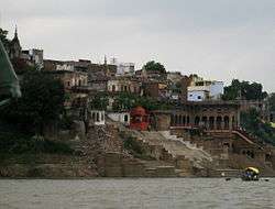
Bariya Ghat | |
 Mirzapur | |
| Coordinates: 25°09′N 82°36′E / 25.15°N 82.60°ECoordinates: 25°09′N 82°36′E / 25.15°N 82.60°E | |
| Country |
|
| State | Uttar Pradesh |
| Elevation | 80 m (260 ft) |
| Population (2011)[1] | |
| • city | 233,691 |
| • Density | 567/km2 (1,470/sq mi) |
| • Metro[2] | 245,817 |
| Languages | |
| • Official | Hindi, Urdu, English |
| Time zone | IST (UTC+5:30) |
| PIN | 231001 |
| Telephone code | 05442 |
| Vehicle registration | UP 63 |
| Sex ratio | 0.903 (2011) |
| Literacy | 68.48% (2011) (78.97%♂; 56.86%♀) |
| Website |
www |
Mirzapur ![]() pronunciation (Hindi:मिर्जापुर Urdu:ݦرزاپور) is a city in Uttar Pradesh, India, roughly 650 km from both Delhi and Kolkata, almost 89 km from Allahabad and 57 km from Varanasi. It has a population of 233,691 (2011 census) and is known for its carpet and brassware industries. The city is surrounded by several hills and is the headquarters of Mirzapur District and is famous for the holy shrine of Vindhyachal, Ashtbhuja and Kali khoh and also have Devrahwa Baba ashram. It has many waterfalls and natural spots. It was once the largest district in India before the split of Sonebhadra.
pronunciation (Hindi:मिर्जापुर Urdu:ݦرزاپور) is a city in Uttar Pradesh, India, roughly 650 km from both Delhi and Kolkata, almost 89 km from Allahabad and 57 km from Varanasi. It has a population of 233,691 (2011 census) and is known for its carpet and brassware industries. The city is surrounded by several hills and is the headquarters of Mirzapur District and is famous for the holy shrine of Vindhyachal, Ashtbhuja and Kali khoh and also have Devrahwa Baba ashram. It has many waterfalls and natural spots. It was once the largest district in India before the split of Sonebhadra.
History
Before the establishment of the town the area was dense forest and freely used by various states like Benaras (Varanasi), Sakteshgarh, Vijaygarh, Nainagarh (Chunar), Naugarh, Kantit and Rewa for Hunting. British East India Company has established this area to fulfill the need of a trading centre between central and western India. This time Rewa was a well-established state of central India and was directly connected with Mirzapur by the Great Deccan Road. Over the time Mirzapur became a famous trading centre of Central India and started trading of cotton, and silk at very large scale.
The East India Company named this place as Mirzapore (मिर्ज़ापुर). The word Mirzapur is derived from 'Mirza' which in turn is derived from the Persian term ‘Trip Kalchu which literally means "child of the ‘Amīr" or "child of the ruler". In Persia‘ Amīrzād in turn consists of the Arabic title ‘Amīr (English. "Emir"), meaning "commander", and the Persian suffix -zād, meaning "birth" or "lineage". Due to vowel harmony in Turkic languages, the alternative pronunciation Morza (plural morzalar; derived from the Persian word) is also used. The word entered English in 1595, from the French émir. The meaning of Mirzapur is the place of King.
Most of the city was established by British officers, but the starting development was founded by the most famous officer of British East India Company "Lord Marquess Wellesley". As per some evidence the British construction was initiated from Burrier (Bariya) Ghat. Lord Wellesley has reconstructed the Burrier Ghat as a main entrance in Mirzapur by Ganga. Some of the places in Mirzapur was pronounced as per the name of Lord Wellesley, like Wellesleyganj (The first market in Mirzapur), Mukeri Bazar, tulsi chowk etc. The building of Municipal Corporation is also a precious example of British Constructions.
It is the place in India where the Holy River Ganges meets with Vindhya Range. This is considered significant in Hindu Mythology and has a mention in Vedas. Near mirzapur founded a religious place vindhyanchal. Vindhyachal, a Shakti Peeth, is a centre of pilgrimage in Mirzapur District, Uttar Pradesh. The Vindhyavasini Devi temple located here is a major draw and is thronged by thousands of devotees during the Navratris of Chaitra and Ashwin months to invoke the blessings of the Goddess. Other sacred places in the town are Ashtbhuja temple, Sita Kund, Kali Khoh, Budeh Nath temple, Narad Ghat, Gerua talab, Motiya talab, Lal Bhairav and Kal Bhairav temples, Ekdant Ganesh, Sapta Sarovar, Sakshi Gopal temple, Goraksha-kund, Matsyendra kund, Tarkeshwar Nath temple, Kankali Devi temple, Shivashiv Samooh Awadhoot Ashram and Bhairav kund. Mirzapur is the closest railhead. Vindhyachal has regular bus services to the nearby towns. The nearest railway station is at Mirzapur. Regular bus services connect Vindhyachal to the nearby towns.
Geography
Mirzapur is located at 25°09′N 82°35′E / 25.15°N 82.58°E.[3] It has an average elevation of 80 metres (265 feet). The District of Mirzapur lies between the parallels of 23.52 & 25.32 North latitude and 82.7 and 83.33 East longitude. It forms a portion of the Varanasi district. On the north and north-east it is bounded by the Varanasi district; on the south bounded by Sonbhadra district; on the north-west by Allahabad district. The shape to the north and west is totally regular. In no direction, except for about 13 km. in the north-east where the Ganges separates the Tehsil of Chunar from the district of Varanasi, has Mirzapur a natural frontier. The Chanvar fields, considered to be one of the most fertile lands tracts in India, are located on Gangetic flood plains of the district. Also, Indian Standard Time is calculated on the basis of 82.5° E longitude, from a clock tower in Mirzapur
According to Central Statistical organisation the district of Mirzapur had an area of 4521 km2. At the census of 2001, the population of the district is 1657140 (males 1093849 and females 980860) of which 1788203 were living in rural and 286506 in the urban area of the district.[4]
Some geographical locations around Mirzapur district is depicted below
 |
Sant Ravidas Nagar district | Varanasi district | | |
| Allahabad district | |
Chandauli district | ||
| ||||
| | ||||
| Rewa district, Madhya Pradesh | Singrauli district, Madhya Pradesh | Sonbhadra district |
Demographics
As of the 2011 census, Mirzapur-cum-Vindhyachal municipality had a population of 233,691[1] and the urban agglomeration had a population of 245,817.[2] The municipality had a sex ratio of 869 females per 1,000 males and 11.9% of the population were under six years old.[1] Effective literacy was 78.25%; male literacy was 83.85% and female literacy was 71.80%.[1]
Commerce
The main business in Mirzapur is carpet manufacturing. Manufacturers range from very small (with less than $100,000 in assets) to medium-sized (with around $10M in assets). Most of the carpets are sold internationally as India has a limited market for carpets. The second main business is of metal pots(brass).
Indian Standard Time calculation
Indian Standard Time is calculated from the clock tower in Mirzapur nearly exactly on the reference longitude of Indian Standard Time at 82.5°, within 4 angular minutes, a property shared by Tuni, a town in Andhra Pradesh.[5]
Tourism
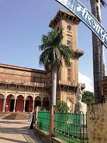
For quite some years Mirzapur has been a destination for tourists, particularly for people from adjoining states, owing mainly to the ghats, temples, the famous clock tower(Ghanta Ghar)which are excellent examples of contemporary architecture. [6] [7]
Temples and mosques
Vindhyachal
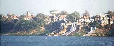
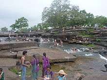
A few miles away from the city is a site of a pilgrimage for Hindus known as Vindhyachal where according to the mythology a part of Sati (an Avatar of Durga) fell. The river Ganges flows through this city. Other sites of pilgrimage include Kali Khoh (literally 'the cave of the Goddess Kali') where a statue of the Kali has a mouth formed in the shape of a cave, hence the name. Very close to the city is a waterfall. The city itself has many Ghats (steps to a river). There are a few cinema-halls. At first look the city appears to be a confluence of town, village and city life. Power supply in the city is now regular up to some extent.
Ghanta Ghar (Clock Tower)
The famous Ghanta Ghar of Mirzapur is located in the premises of city corporation, about 3 km from the Mirzapur Railway Station. Currently not functioning, it was constructed in the year 1891, with its entire structure made up of finely carved stone and a 1000 kg alloy bell hanging from the tall structure.
Ghats

Ojhala Bridge
The Ojhala Bridge was constructed by Mahant Parshuram Giri in Vikram Samvat 1772. This valuable heritage connecting the cities of Mirzapur and Vindhyachal, with fort like minarets and ramparts on the either side of the bridge, provide a fine instance of contemporary architecture.
Culture

- Festivals of the city: jeevitputrika (jutiya), Ganges Deshahara, lalahi chattha, shardiya and vasantik navratra, ojhala ka mela (a fair at the Ojhla Bridge), lohandi ka mela (fair), the famous Vindhya Mahotsava, horaha gaderi ka mela, litti bati ka mela, and maa bhandari ka mela (various fairs at different places on different occasions).
- Kajari Mahotsava: It is among the famous festivals of Mirzapur. Respected all over India, kajali took birth here. King Kantit 9Naresh's daughter Kajali loved her husband very much and sang songs in the moment of separation from her husband, although she could not meet her husband throughout her life and died, yet she remains alive through these deep sad-love songs. Her voice and songs impress Mirzapur locals very much, so they remember her through this festival paying homage to her.
- Lohandi Mela: 2 km south of Mirzapur an old temple of Lord Hanuman is decorated with light (ghee ke deeye) on kartik purnima and every Saturday in the month of Saawan (Hindu month of rain in the middle of July–August), a big fair is arranged. The attraction is tattoo design.
- Ojhala Mela: Ojhala is the current name of the Ujjvala River. A fair used to be arranged regularly here since 1920, which is a sign of bravery and the only place in India where betting is legal on the days of the fair. This has been discontinued since there is not enough water at the bridge for the various water sports that used to take place.
- Vindhyavasini Jayanti Samaaroh: Started in 1971, this musical program is arranged by the Government where renowned Indian vocal and folk artists give real presentations and worship the goddess Vindhyavasini.
- Deep Mahotsava: Celebrated on the day of Diwali, all the Ganges ghats are decorated with lights, locals have immense pleasure celebrating this on kartik amavasya.
- Jhoolanotsava: In the month of Saawan celebrated by locals during rain, this Jhoolanotsava is celebrated with swings in the branches of trees for four days. Shree Dwarkadheesh Temple, Ganga Jamuna Saraswati Temple and Kunj Bhawan are decorated at the Rakshabandhan festival.
- Kantit Mela: Near Vindhyachal railways station, a tomb of Hajrat Khwaja Ismail Chisti, who was related with Khwaja Moin-U-Din Chisti – Ajmer, Rajasthan, is located. On the sixth day of the month of Rajab (Islamic calendar), Kantit Mela is celebrated by locals and outsiders. This Mela is a symbol of brotherhood(Bhaichara) in which people from different religious groups celebrate with joy and happiness.
- Nagpanchami Mela :It is organised at the night of nagpanchami in Ganesh ganj near Mukeri bazar where all the temples being decorated and several shops of food and culture are open that day where thousands of people visit.
Education
Being a vast emerging centre of tradition,culture & civilisation[8] the city which get blessed by Holy river Ganges accept itself as the need of time to deliver the adequate quality education. The youth of the city trend themselves as per the demand of modern era. The district itself is the centre of more than 75 colleges[9] for the youth having more than 20,200 enrolments per year reported by the DEPARTMENT OF HIGHER EDUCATION MINISTRY OF HUMAN RESOURCE survey for higher education in 2014.Due to connective with two major cities of Uttar Pradesh i.e. Varanasi & Allahabad the city itself get blessed by Maa Vindhyavasini along with Kashi Vishwanath.
The relation of education with Kashi and establishment of Banaras Hindu University start in 1878 when Pt. Mahamana Madan Mohan Malviya accept the daughter of city Sri Kundan Devi as Life partner.[10] After well establishment of BHU in Varanasi, Mirzapur benefitted as University known as Rajiv Gandhi South Campus at Barkachha[11] acquired by BHU , on lease in perpetuity from Bharat Mandal Trust[12] in April 1979 with an area of 1104 hectare situated about 8 km South West of Mirzapur City. At present RGSC (Rajiv Gandhi South Campus) is spread over 2700 acres and has been used to run special courses of Banaras Hindu University. This campus is situated in the lap of nature and gives a feeling of Gurukul in this modern era. Very soon a Veterinary college will also open as a part of RGSC, BHU.
Chunar
About 32 km from Mirzapur is the famous fortress of Chunar.
There are some rock paintings in Mirzapur district.
Hasauli is the first ever nirmal village which was awarded by president APJ Abdul Kalam and it is also famous for its handicrafts.
Chunar is fort of King Shivdautt. Before 7–8 km from Chunar Railways station, there is a village Usarahawa on N H-7.
Kachhwa bazaar
Kachhwa is a town and a nagar panchayat in Mirzapur district, located at 25.22°N 82.72°E.[1] It has an average elevation of 84 metres (275 feet). It is around 35 km. away from Varanasi Cantt. This place is known for Kachhwa Christian hospital, which was set by Christian missionary Dr Neville Everad to provide medical care to the nearby town.
Kachhwa is one of biggest markets in Mirzapur.
References
- 1 2 3 4 "Provisional Population Totals, Census of India 2011; Cities having population 1 lakh and above" (PDF). Office of the Registrar General & Census Commissioner, India. Retrieved 26 March 2012.
- 1 2 "Provisional Population Totals, Census of India 2011; Urban Agglomerations/Cities having population 1 lakh and above" (PDF). Office of the Registrar General & Census Commissioner, India. Retrieved 26 March 2012.
- ↑ Falling Rain Genomics, Inc – Mirzapur. Fallingrain.com. Retrieved on 1 June 2012.
- ↑ Mirzaput at a glance. Mirzapur.nic.in. Retrieved on 1 June 2012.
- ↑ India investigates different time zones. BBC. 21 August 2001
- ↑ added on 23 June 2013
- ↑ added on 23 June 2013
- ↑ "KAJARI".
- ↑ "Ministry of Human Resource 2014" (PDF).
- ↑ "RGSC About Campus". www.bhu.ac.in. Retrieved 15 April 2016.
- ↑ "Rajiv Gandhi South Campus".
- ↑ "BHU South Campus".
External links
| Wikimedia Commons has media related to Mirzapur. |