National Register of Historic Places listings in Chaves County, New Mexico
Location of Chaves County in New Mexico
This is a list of the National Register of Historic Places listings in Chaves County, New Mexico.
This is intended to be a complete list of the properties and districts on the National Register of Historic Places in Chaves County, New Mexico, United States. Latitude and longitude coordinates are provided for many National Register properties and districts; these locations may be seen together in a map.[1]
There are 18 properties and districts listed on the National Register in the county.
- This National Park Service list is complete through NPS recent listings posted December 16, 2016.[2]
Current listings
| [3] |
Name on the Register[4] |
Image |
Date listed[5] |
Location |
City or town |
Description |
|---|
| 1 |
CA Bar Ranch |
Upload image |
000000001988-08-29-0000August 29, 1988
(#85003634) |
U.S. Route 82 3 miles west of its junction with State Road 24
32°53′38″N 105°13′26″W / 32.893889°N 105.223889°W / 32.893889; -105.223889 (CA Bar Ranch) |
Mayhill |
|
| 2 |
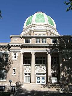
Chaves County Courthouse |
|
000000001989-02-15-0000February 15, 1989
(#87000892) |
400 block of Main St.
33°23′49″N 104°31′17″W / 33.396944°N 104.521389°W / 33.396944; -104.521389 (Chaves County Courthouse) |
Roswell |
|
| 3 |
Diamond A Ranch |
Upload image |
000000001988-08-29-0000August 29, 1988
(#85003635) |
U.S. Route 380 14 miles west of Roswell
33°21′06″N 104°51′08″W / 33.351667°N 104.852222°W / 33.351667; -104.852222 (Diamond A Ranch) |
Roswell |
|
| 4 |
Downtown Roswell Historic District |
Upload image |
000000001985-05-16-0000May 16, 1985
(#85001543) |
Roughly bounded by 8th St., Richardson Ave., Albuquerque St., and Missouri Ave.
33°24′05″N 104°31′36″W / 33.401389°N 104.526667°W / 33.401389; -104.526667 (Downtown Roswell Historic District) |
Roswell |
|
| 5 |
Flying H Ranch |
Upload image |
000000001988-09-14-0000September 14, 1988
(#85003633) |
Off U.S. Route 70 between Hope and Elk Area
33°00′41″N 105°08′22″W / 33.011389°N 105.139444°W / 33.011389; -105.139444 (Flying H Ranch) |
Roswell |
|
| 6 |
Patrick Floyd Garrett House |
Upload image |
000000001988-08-29-0000August 29, 1988
(#85003637) |
Bosque Rd. 3 miles north of Roswell
33°24′14″N 104°26′17″W / 33.403889°N 104.438056°W / 33.403889; -104.438056 (Patrick Floyd Garrett House) |
Roswell |
|
| 7 |
Robert H. Goddard House |
Upload image |
000000001988-07-15-0000July 15, 1988
(#85003594) |
Route 3 E. on Mescalero Rd.
33°25′53″N 104°30′07″W / 33.431389°N 104.501944°W / 33.431389; -104.501944 (Robert H. Goddard House) |
Roswell |
|
| 8 |
Louise Massey House |
|
000000001985-05-16-0000May 16, 1985
(#85001544) |
209 W. Alameda St.
33°23′28″N 104°31′32″W / 33.391176°N 104.525477°W / 33.391176; -104.525477 (Louise Massey House) |
Roswell |
Home of country singer Louise Massey
|
| 9 |
Millhiser-Baker Farm |
Upload image |
000000001988-08-29-0000August 29, 1988
(#85003638) |
Route 1 0.5 miles south of McGaffey
33°22′26″N 104°33′04″W / 33.373889°N 104.551111°W / 33.373889; -104.551111 (Millhiser-Baker Farm) |
Roswell |
|
| 10 |
Milne-Bush Ranch |
Upload image |
000000001988-08-29-0000August 29, 1988
(#85003639) |
Route 1
33°26′19″N 104°29′55″W / 33.438611°N 104.498611°W / 33.438611; -104.498611 (Milne-Bush Ranch) |
Roswell |
|
| 11 |
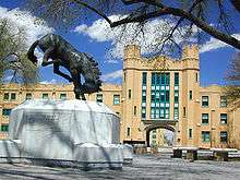
New Mexico Military Institute Historic District |
|
000000001987-05-07-0000May 7, 1987
(#87000907) |
Roughly bounded by 19th and N. Main Sts., College Boulevard, and Kentucky Ave.
33°19′52″N 104°31′31″W / 33.331111°N 104.525278°W / 33.331111; -104.525278 (New Mexico Military Institute Historic District) |
Roswell |
|
| 12 |
Ozark Trails Marker at Lake Arthur |
Upload image |
000000002004-07-16-0000July 16, 2004
(#04000702) |
Junction of Main and Broadway Sts.
33°00′00″N 104°21′57″W / 33.0°N 104.365833°W / 33.0; -104.365833 (Ozark Trails Marker at Lake Arthur) |
Lake Arthur |
|
| 13 |
Rio Felix Bridge At Hagerman |
Upload image |
000000001997-07-15-0000July 15, 1997
(#97000737) |
U.S. Route 285 over Rio Felix
33°07′51″N 104°20′09″W / 33.130833°N 104.335833°W / 33.130833; -104.335833 (Rio Felix Bridge At Hagerman) |
Hagerman |
|
| 14 |
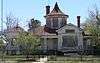
Saunders-Crosby House |
|
000000001985-05-16-0000May 16, 1985
(#85001545) |
200 E. Deming
33°23′07″N 104°31′14″W / 33.385384°N 104.520628°W / 33.385384; -104.520628 (Saunders-Crosby House) |
Roswell |
|
| 15 |
Slaughter-Hill Ranch |
Upload image |
000000001988-08-29-0000August 29, 1988
(#85003640) |
1601 E. 2nd St.
33°23′52″N 104°29′47″W / 33.397778°N 104.496389°W / 33.397778; -104.496389 (Slaughter-Hill Ranch) |
Roswell |
|
| 16 |
South Spring Ranch |
Upload image |
000000001989-04-24-0000April 24, 1989
(#88003465) |
Route 2
33°20′46″N 104°28′10″W / 33.346111°N 104.469444°W / 33.346111; -104.469444 (South Spring Ranch) |
Roswell |
|
| 17 |
Urton Orchards |
Upload image |
000000001988-08-29-0000August 29, 1988
(#85003641) |
Route 3
33°26′04″N 104°29′10″W / 33.434444°N 104.486111°W / 33.434444; -104.486111 (Urton Orchards) |
Roswell |
|
| 18 |
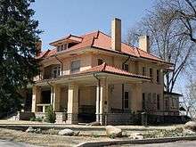
James Phelps White House |
|
000000001978-07-24-0000July 24, 1978
(#78001812) |
200 N. Lea Ave.
33°23′40″N 104°31′44″W / 33.394444°N 104.528889°W / 33.394444; -104.528889 (James Phelps White House) |
Roswell |
|
See also
References
- ↑ The latitude and longitude information provided in this table was derived originally from the National Register Information System, which has been found to be fairly accurate for about 99% of listings. For about 1% of NRIS original coordinates, experience has shown that one or both coordinates are typos or otherwise extremely far off; some corrections may have been made. A more subtle problem causes many locations to be off by up to 150 yards, depending on location in the country: most NRIS coordinates were derived from tracing out latitude and longitudes off of USGS topographical quadrant maps created under the North American Datum of 1927, which differs from the current, highly accurate WGS84 GPS system used by most on-line maps. Chicago is about right, but NRIS longitudes in Washington are higher by about 4.5 seconds, and are lower by about 2.0 seconds in Maine. Latitudes differ by about 1.0 second in Florida. Some locations in this table may have been corrected to current GPS standards.
- ↑ "National Register of Historic Places: Weekly List Actions". National Park Service, United States Department of the Interior. Retrieved on December 16, 2016.
- ↑ Numbers represent an ordering by significant words. Various colorings, defined here, differentiate National Historic Landmarks and historic districts from other NRHP buildings, structures, sites or objects.
- ↑ National Park Service (2008-04-24). "National Register Information System". National Register of Historic Places. National Park Service.
- ↑ The eight-digit number below each date is the number assigned to each location in the National Register Information System database, which can be viewed by clicking the number.
|
|---|
|
| Topics | |
|---|
|
| Lists by states | |
|---|
|
| Lists by insular areas | |
|---|
|
| Lists by associated states | |
|---|
|
| Other areas | |
|---|
|
-
 Portal Portal
-
 WikiProject WikiProject
|