| [3] |
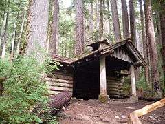
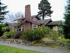
Name on the Register[4] |
Image |
Date listed[5] |
Location |
City or town |
Description |
|---|
| 1 |
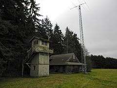
Aircraft Warning Service Observation Tower |
|
000000001993-04-29-0000April 29, 1993
(#93000363) |
216 Spring Rd.
48°06′13″N 123°14′59″W / 48.103611°N 123.249722°W / 48.103611; -123.249722 (Aircraft Warning Service Observation Tower) |
Agnew |
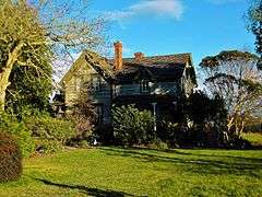
|
| 2 |
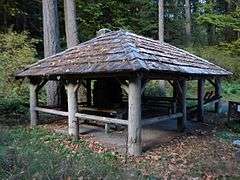
Altair Campground Community Kitchen |
|
000000002007-07-13-0000July 13, 2007
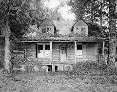
(#07000732) |
Approx. 4 mi. S of US 101
48°00′42″N 123°35′30″W / 48.011667°N 123.591667°W / 48.011667; -123.591667 (Altair Campground Community Kitchen) |
Port Angeles |
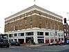
|
| 3 |
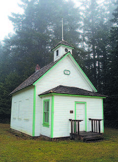
Beaver School |
|
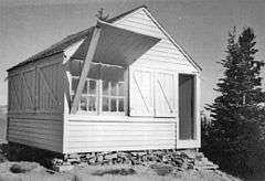
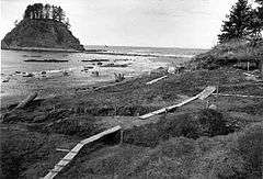
000000001992-11-19-0000November 19, 1992
(#92001591) |
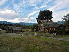
US 101 N, W side
48°03′50″N 124°18′38″W / 48.063889°N 124.310556°W / 48.063889; -124.310556 (Beaver School) |
Beaver |
Rural Public Schools of Washington State MPS
|
| 4 |
Blue Mountain School |
|
000000001987-11-05-0000November 5, 1987
(#87001938) |
Blue Mountain Rd.
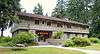
48°03′02″N 123°16′21″W / 48.050556°N 123.2725°W / 48.050556; -123.2725 (Blue Mountain School) |
Port Angeles |
Rural Public Schools of Washington State MPS
|
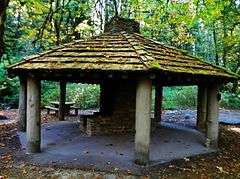
| 5 |
Canyon Creek Shelter |
|
000000002007-07-13-0000July 13, 2007
(#07000712) |
Approximately .9 miles north of the Upper Sol Duc River Trailhead
47°57′00″N 123°49′05″W / 47.9499°N 123.8180°W / 47.9499; -123.8180 (Canyon Creek Shelter) |
Port Angeles |
|
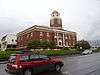
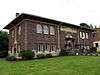
| 6 |
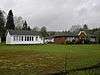
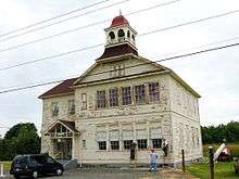
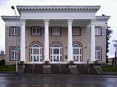
Clallam County Courthouse |
|
000000001987-09-02-0000September 2, 1987
(#87001459) |
319 Lincoln St.
48°06′57″N 123°25′55″W / 48.115833°N 123.431944°W / 48.115833; -123.431944 (Clallam County Courthouse) |
Port Angeles |
|
| 7 |
Dodger Point Fire Lookout |
|
000000002007-07-13-0000July 13, 2007
(#07000736) |
Approx. 13 mi. along Dodger Point Trail starting at the Whiskey Bend Trail
47°52′29″N 123°30′29″W / 47.874722°N 123.508056°W / 47.874722; -123.508056 (Dodger Point Fire Lookout) |
Port Angeles |
|
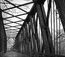
| 8 |
Dungeness River Bridge |
|
000000001982-07-16-0000July 16, 1982
(#82004201) |
Spans Dungeness River
48°05′08″N 123°08′46″W / 48.085556°N 123.146111°W / 48.085556; -123.146111 (Dungeness River Bridge) |
Sequim |
Historic Bridges and Tunnels in Washington TR
|
| 9 |
Dungeness School |
|
000000001988-05-19-0000May 19, 1988
(#88000627) |
657 Towne Rd.
48°08′34″N 123°07′38″W / 48.142778°N 123.127222°W / 48.142778; -123.127222 (Dungeness School) |
Dungeness |
Rural Public Schools of Washington State MPS
|
| 10 |
Eagle Ranger Station |
|
000000002007-07-13-0000July 13, 2007
(#07000713) |
Approximately 11.6 miles south of WA 101 on Upper Sol Duc Rd.
47°58′19″N 123°51′52″W / 47.971944°N 123.864444°W / 47.971944; -123.864444 (Eagle Ranger Station) |
Port Angeles |
|
| 11 |
Elkhorn Guard Station |
Upload image |
000000002007-07-13-0000July 13, 2007
(#07000714) |
Approximately 11.5 miles along Elwha River Trail from the Whiskey Bend Trailhead
47°52′16″N 123°28′03″W / 47.8711°N 123.4674°W / 47.8711; -123.4674 (Elkhorn Guard Station) |
Port Angeles |
|
| 12 |
Elwha Campground Community Kitchen |
|
000000002007-07-13-0000July 13, 2007
(#07000735) |
3 miles south of U.S. Route 101 in Washington
48°01′39″N 123°35′13″W / 48.0275°N 123.586944°W / 48.0275; -123.586944 (Elwha Campground Community Kitchen) |
Port Angeles |
|
| 13 |
Elwha Ranger Station |
|
000000002007-07-13-0000July 13, 2007
(#07000716) |
Approximately 3 miles southeast of WA 101 on the Olympic Hot Springs Rd.
48°01′00″N 123°35′27″W / 48.016667°N 123.590833°W / 48.016667; -123.590833 (Elwha Ranger Station) |
Port Angeles |
|
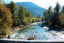
| 14 |
Elwha River Bridge |
|
000000001982-07-16-0000July 16, 1982
(#82004200) |
Old Hwy. 112
48°06′04″N 123°33′23″W / 48.101111°N 123.556389°W / 48.101111; -123.556389 (Elwha River Bridge) |
Elwha |
Historic Bridges and Tunnels in Washington TR. Photo shows the view from the replacement bridge.
|
| 15 |
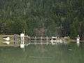
Elwha River Hydroelectric Power Plant |
|
000000001988-12-15-0000December 15, 1988
(#88002741) |
N end of Lake Aldwell
48°05′42″N 123°33′18″W / 48.095°N 123.555°W / 48.095; -123.555 (Elwha River Hydroelectric Power Plant) |
Port Angeles |
|
| 16 |
Emery Farmstead |
|
000000001988-12-16-0000December 16, 1988
(#88002746) |
Emery Rd.
48°04′12″N 123°15′41″W / 48.07°N 123.261389°W / 48.07; -123.261389 (Emery Farmstead) |
Port Angeles |
|
| 17 |
Fifteen Mile Shelter |
Upload image |
000000002007-07-13-0000July 13, 2007
(#07000715) |
Approx. 12.4 mi. from park boundary on N Fork Bogachiel R Trail
47°54′10″N 124°01′14″W / 47.902778°N 124.020556°W / 47.902778; -124.020556 (Fifteen Mile Shelter) |
Port Angeles |
|
| 18 |
Glines Canyon Hydroelectric Power Plant |
|
000000001988-12-15-0000December 15, 1988
(#88002742) |
N end of Lake Mills at Elwha River
48°00′11″N 123°35′54″W / 48.003056°N 123.598333°W / 48.003056; -123.598333 (Glines Canyon Hydroelectric Power Plant) |
Port Angeles |
|
| 19 |
Hoko River Archeological Site |
|
000000001978-03-21-0000March 21, 1978
(#78002735) |
Address Restricted
|
Pysht |
|
| 20 |
Hoko River Rockshelter Archeological Site |
|
000000001980-03-27-0000March 27, 1980
(#80003997) |
Address Restricted
|
Sekiu |
|
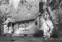
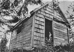
| 21 |
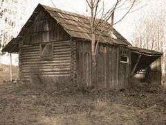
Humes Ranch Cabin |
|
000000001977-09-14-0000September 14, 1977
(#77001332) |
S of Port Angeles on Elwha River
47°56′53″N 123°32′39″W / 47.948056°N 123.544167°W / 47.948056; -123.544167 (Humes Ranch Cabin) |
Port Angeles |
|
| 22 |
Hyak Shelter |
Upload image |
000000002007-07-13-0000July 13, 2007
(#07000721) |
Approx. 15.4 mi. from park boundary on N Fork Bogachiel River Trail
47°55′27″N 123°58′14″W / 47.924167°N 123.970556°W / 47.924167; -123.970556 (Hyak Shelter) |
Port Angeles |
|
| 23 |
John A. Hyer Farm |
|
000000001994-07-29-0000July 29, 1994
(#94000797) |
Address Restricted
|
Sequim |
|
| 24 |
Manis Mastodon Site |
|
000000001978-03-21-0000March 21, 1978
(#78002736) |
Address Restricted
|
Sequim |
|
| 25 |
Masonic Temple |
|
000000001989-05-11-0000May 11, 1989
(#89000400) |
622 S. Lincoln St.
48°06′48″N 123°26′08″W / 48.113333°N 123.435556°W / 48.113333; -123.435556 (Masonic Temple) |
Port Angeles |
|
| 26 |
McAlmond House |
|
000000001976-08-09-0000August 9, 1976
(#76001879) |
N of Sequim on Dungeness Bay
48°09′03″N 123°08′05″W / 48.150833°N 123.134722°W / 48.150833; -123.134722 (McAlmond House) |
Sequim |
|
| 27 |
Michael's Cabin |
Upload image |
000000002007-07-13-0000July 13, 2007
(#07000733) |
Along Elwha River Trail; approx 2 mi. from Whiskey Bend Trailhead
47°57′12″N 123°33′11″W / 47.953333°N 123.553056°W / 47.953333; -123.553056 (Michael's Cabin) |
Port Angeles |
|
| 28 |
Naval Lodge Elks Building |
|
000000001986-05-02-0000May 2, 1986
(#86000956) |
131 E. First St.
48°07′07″N 123°25′51″W / 48.118611°N 123.430833°W / 48.118611; -123.430833 (Naval Lodge Elks Building) |
Port Angeles |
|
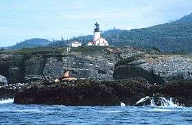
| 29 |
New Dungeness Light Station |
|
000000001993-11-30-0000November 30, 1993
(#93001338) |
Dungeness Spit
48°10′56″N 123°06′17″W / 48.182222°N 123.104722°W / 48.182222; -123.104722 (New Dungeness Light Station) |
Sequim |
|
| 30 |
North Fork Sol Duc Shelter |
Upload image |
000000002007-07-13-0000July 13, 2007
(#07000725) |
Approx. 9.5 mi. from North Fork Sol Duc Trailhead
47°59′56″N 123°45′42″W / 47.998889°N 123.761667°W / 47.998889; -123.761667 (North Fork Sol Duc Shelter) |
Port Angeles |
|
| 31 |
Olympic National Park Headquarters Historic District |
|
000000002007-07-13-0000July 13, 2007
(#07000720) |
600 E. Park Ave.
48°06′03″N 123°25′58″W / 48.100833°N 123.432778°W / 48.100833; -123.432778 (Olympic National Park Headquarters Historic District) |
Port Angeles |
|
| 32 |
Ozette Indian Village Archeological Site |
|
000000001974-01-11-0000January 11, 1974
(#74000916) |
Address Restricted
|
La Push |
|
| 33 |
Joseph Paris House |
|
000000001987-11-05-0000November 5, 1987
(#87001939) |
101 E. Fifth St.
48°06′57″N 123°26′06″W / 48.115833°N 123.435°W / 48.115833; -123.435 (Joseph Paris House) |
Port Angeles |
|
| 34 |
Port Angeles Civic Historic District |
|
000000002011-05-04-0000May 4, 2011
(#11000259) |
205, 215, 217 & 319 S. Lincoln St.
48°07′01″N 123°25′58″W / 48.116944°N 123.432778°W / 48.116944; -123.432778 (Port Angeles Civic Historic District) |
Port Angeles |
Includes former Carnegie Library (1918), City Building (1930) and former Clallam County Courthouse, which is individually listed on the register.
|
| 35 |
Pyramid Peak Aircraft Warning Service Lookout |
|
000000002007-07-13-0000July 13, 2007
(#07000726) |
3.5 miles up Pyramid Pk.trail at end of Camp David Jr. Rd.
48°04′30″N 123°48′44″W / 48.075°N 123.812222°W / 48.075; -123.812222 (Pyramid Peak Aircraft Warning Service Lookout) |
Port Angeles |
|
| 36 |
Peter Roose Homestead |
|
000000002007-07-13-0000July 13, 2007
(#07000723) |
Along Indian Village Trail; approximately 1.5 miles north of trailhead[6]
48°09′42″N 124°42′24″W / 48.1617°N 124.7067°W / 48.1617; -124.7067 (Peter Roose Homestead) |
Port Angeles |
|
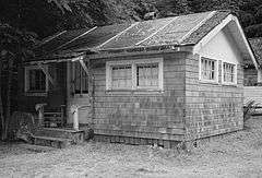
| 37 |
Rosemary Inn |
|
000000001979-07-17-0000July 17, 1979
(#79001033) |
SW of Port Angeles on Barnes Point
48°03′36″N 123°47′33″W / 48.06°N 123.7925°W / 48.06; -123.7925 (Rosemary Inn) |
Port Angeles |
|
| 38 |
Sekiu School |
|
000000001991-05-01-0000May 1, 1991
(#91000539) |
Rice St.
48°15′47″N 124°18′02″W / 48.263056°N 124.300556°W / 48.263056; -124.300556 (Sekiu School) |
Sekiu |
Rural Public Schools of Washington State MPS
|
| 39 |
Sequim Opera House |
|
000000001991-05-28-0000May 28, 1991
(#91000632) |
119 N. Sequim Ave.
48°04′49″N 123°06′04″W / 48.080278°N 123.101111°W / 48.080278; -123.101111 (Sequim Opera House) |
Sequim |
|
| 40 |
Singer's Lake Crescent Tavern |
|
000000002007-07-13-0000July 13, 2007
(#07000724) |
Barnes Point, south shore of Lake Crescent, WA 101
48°03′25″N 123°48′00″W / 48.056944°N 123.8°W / 48.056944; -123.8 (Singer's Lake Crescent Tavern) |
Port Angeles |
|
| 41 |
St. Andrew's Episcopal Church |
|
000000001987-11-05-0000November 5, 1987
(#87001942) |
206 S. Peabody St.
48°06′58″N 123°25′41″W / 48.116111°N 123.428056°W / 48.116111; -123.428056 (St. Andrew's Episcopal Church) |
Port Angeles |
|
| 42 |
Storm King Ranger Station |
|
000000002007-07-13-0000July 13, 2007
(#07000730) |
Barnes Pt., S side of Lake Crescent off US 101
48°03′29″N 123°47′14″W / 48.058056°N 123.787222°W / 48.058056; -123.787222 (Storm King Ranger Station) |
Port Angeles |
|
| 43 |
Tatoosh Island |
|
000000001972-03-16-0000March 16, 1972
(#72001267) |
NW of Cape Flattery
48°23′31″N 124°44′01″W / 48.391944°N 124.733611°W / 48.391944; -124.733611 (Tatoosh Island) |
Olympic Peninsula |
|
| 44 |
Three Forks Shelter |
Upload image |
000000002007-07-13-0000July 13, 2007
(#07000728) |
Approx. 4.5 mi. from the Three Fords Trailhead at Deer Park Campground
47°54′56″N 123°14′44″W / 47.915556°N 123.245556°W / 47.915556; -123.245556 (Three Forks Shelter) |
Port Angeles |
|
| 45 |
Tse whit zen Village |
|
000000002014-10-08-0000October 8, 2014
(#14000848) |
Address Restricted
48°07′49″N 123°27′42″W / 48.1302°N 123.4618°W / 48.1302; -123.4618 (Tse whit zen Village) |
Port Angeles vicinity |
|
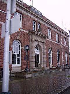
| 46 |
U.S. Post Office |
|
000000001983-09-01-0000September 1, 1983
(#83003321) |
W. 1st and Oak Sts.
48°07′10″N 123°26′02″W / 48.119444°N 123.433889°W / 48.119444; -123.433889 (U.S. Post Office) |
Port Angeles |
|
| 47 |
US Quarantine Station Surgeon's Residence |
|
000000001989-05-11-0000May 11, 1989
(#89000401) |
101 Discovery Way, Diamond Point
48°05′40″N 122°55′10″W / 48.094444°N 122.919444°W / 48.094444; -122.919444 (US Quarantine Station Surgeon's Residence) |
Sequim |
|
| 48 |
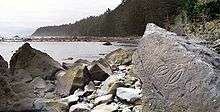
Wedding Rock Petroglyphs |
|
000000001976-04-03-0000April 3, 1976
(#76000951) |
Address Restricted
|
Forks |
|
| 49 |
Wendel Property |
Upload image |
000000002007-07-13-0000July 13, 2007
(#07000739) |
5 miles north on East Shore Rd.
48°05′42″N 123°47′59″W / 48.095°N 123.799722°W / 48.095; -123.799722 (Wendel Property) |
Port Angeles |
|


.jpg)
.JPG)
.jpg)