| [5] |
Name on the Register[6] |
Image |
Date listed[7] |
Location |
City or town |
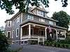
Description |
|---|
| 1 |
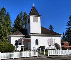
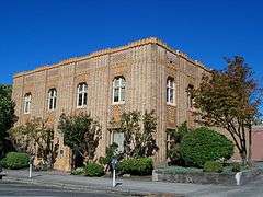
Amboy United Brethren Church |
|
000000002008-12-04-0000December 4, 2008
(#08001184) |
21416 NE 399th Street
45°54′37″N 122°27′12″W / 45.9103°N 122.453247°W / 45.9103; -122.453247 (Amboy United Brethren Church) |
Amboy |
|
| 2 |
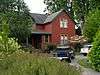
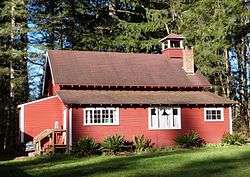
Anderson–Beletski Prune Farm |
|
000000001986-05-15-0000May 15, 1986
(#86001100) |
4119 NW McCann Road
45°43′01″N 122°42′51″W / 45.716885°N 122.714155°W / 45.716885; -122.714155 (Anderson–Beletski Prune Farm) |
Vancouver |
|
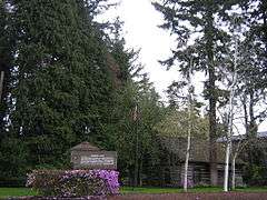
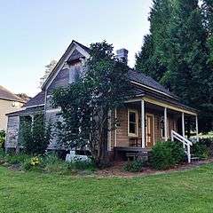
| 3 |
Arndt Prune Dryer |
|
000000001979-10-04-0000October 4, 1979
(#79002527) |
2109 NW 219th Street
45°46′43″N 122°41′37″W / 45.778657°N 122.693582°W / 45.778657; -122.693582 (Arndt Prune Dryer) |
Ridgefield vicinity |
|
| 4 |
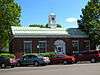
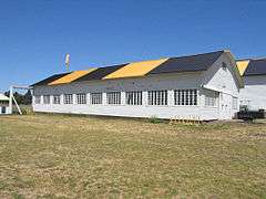
Basalt Cobblestone Quarries District |
|
000000001981-12-14-0000December 14, 1981
(#81000587) |
Ridgefield National Wildlife Refuge
45°50′31″N 122°45′55″W / 45.841944°N 122.765278°W / 45.841944; -122.765278 (Basalt Cobblestone Quarries District) |
Ridgefield |
|
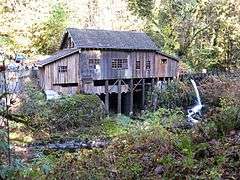
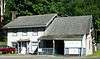
| 5 |
Cedar Creek Grist Mill |
|
000000001975-03-26-0000March 26, 1975
(#75001844) |
9 miles (14 km) east of Woodland on Cedar Creek
45°56′18″N 122°34′54″W / 45.938333°N 122.581667°W / 45.938333; -122.581667 (Cedar Creek Grist Mill) |
Woodland |
|
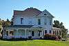
| 6 |
Chumasero–Smith House |
|
000000001998-04-07-0000April 7, 1998
(#98000282) |
310 W. 11th Street
45°37′50″N 122°40′22″W / 45.630556°N 122.672778°W / 45.630556; -122.672778 (Chumasero–Smith House) |
Vancouver |
|
| 7 |
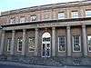
Clark County Courthouse |
|
000000002014-04-11-0000April 11, 2014
(#14000165) |
1200 Franklin Street
45°37′49″N 122°40′39″W / 45.630362°N 122.677579°W / 45.630362; -122.677579 (Clark County Courthouse) |
Vancouver |
|
| 8 |
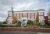
Clark County Poor Farm – Southwestern Washington Experiment Station |
|
000000002013-01-07-0000January 7, 2013
(#12001159) |
1919 NE 78th Street
45°40′32″N 122°39′00″W / 45.675542°N 122.649976°W / 45.675542; -122.649976 (Clark County Poor Farm – Southwestern Washington Experiment Station) |
Vancouver vicinity |
|
| 9 |
Covington House |
|
000000001972-05-05-0000May 5, 1972
(#72001268) |
4201 Main Street
45°39′10″N 122°39′55″W / 45.652778°N 122.665278°W / 45.652778; -122.665278 (Covington House) |
Vancouver |
|
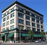
| 10 |
Elks Building |
|
000000001983-07-14-0000July 14, 1983
(#83003322) |
916 Main Street
45°37′43″N 122°40′19″W / 45.628585°N 122.671954°W / 45.628585; -122.671954 (Elks Building) |
Vancouver |
|
| 11 |
Evergreen Hotel |
|
000000001979-01-01-0000January 1, 1979
(#79002529) |
500 Main Street
45°37′31″N 122°40′15″W / 45.625278°N 122.670833°W / 45.625278; -122.670833 (Evergreen Hotel) |
Vancouver |
|
| 12 |
Farrell Building |
|
000000002006-03-15-0000March 15, 2006
(#06000135) |
305 NE 4th Avenue
45°35′15″N 122°24′18″W / 45.5875°N 122.405°W / 45.5875; -122.405 (Farrell Building) |
Camas |
|
| 13 |
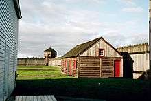
Fort Vancouver National Historic Site |
|
000000001966-10-15-0000October 15, 1966
(#66000370) |
Southeast of downtown, and east of Interstate 5
45°37′24″N 122°39′35″W / 45.623333°N 122.659722°W / 45.623333; -122.659722 (Fort Vancouver National Historic Site) |
Vancouver |
|
| 14 |
Glenwood School |
|
000000001992-06-11-0000June 11, 1992
(#92000697) |
Southeast corner of the junction of NE 87th Avenue and NE 134th Street
45°43′06″N 122°35′00″W / 45.718209°N 122.583293°W / 45.718209; -122.583293 (Glenwood School) |
Glenwood vicinity |
Rural Public Schools of Washington State MPS
|
| 15 |
Albert and Letha Green House and Barn |
|
000000001982-02-19-0000February 19, 1982
(#82004202) |
25716 NE Lewisville Highway
45°48′33″N 122°32′53″W / 45.809096°N 122.547991°W / 45.809096; -122.547991 (Albert and Letha Green House and Barn) |
Battle Ground vicinity |
|
| 16 |
Henry Heisen House |
|
000000001979-10-04-0000October 4, 1979
(#79002526) |
27904 NE 174th Avenue
45°49′29″N 122°29′38″W / 45.824798°N 122.493845°W / 45.824798; -122.493845 (Henry Heisen House) |
Heisson |
|
| 17 |
Hidden Houses |
|
000000001978-11-29-0000November 29, 1978
(#78002737) |
100 and 110 W. 13th Street
45°37′53″N 122°40′16″W / 45.631389°N 122.671111°W / 45.631389; -122.671111 (Hidden Houses) |
Vancouver |
|
| 18 |
House of Providence |
|
000000001978-12-01-0000December 1, 1978
(#78002738) |
400 E. Evergreen Boulevard
45°37′47″N 122°40′01″W / 45.629722°N 122.666944°W / 45.629722; -122.666944 (House of Providence) |
Vancouver |
|
| 19 |
John P. and Mary Kiggins House |
|
000000001995-06-30-0000June 30, 1995
(#95000804) |
411 E. Evergreen Boulevard
45°37′47″N 122°40′01″W / 45.629722°N 122.666944°W / 45.629722; -122.666944 (John P. and Mary Kiggins House) |
Vancouver |
|
| 20 |
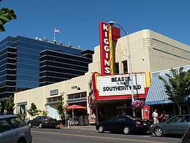
Kiggins Theater |
|
000000002012-07-17-0000July 17, 2012
(#12000421) |
1011 Main Street
45°37′45″N 122°40′17″W / 45.62926°N 122.67132°W / 45.62926; -122.67132 (Kiggins Theater) |
Vancouver |
part of the Movie Theaters in Washington State Multiple Property Submission
|
| 21 |
Lambert School |
|
000000001989-03-16-0000March 16, 1989
(#89000216) |
21814 NW 11th Avenue
45°46′47″N 122°40′55″W / 45.779722°N 122.681944°W / 45.779722; -122.681944 (Lambert School) |
Ridgefield |
Rural Public Schools of Washington State MPS
|
| 22 |
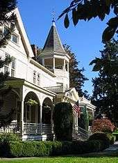
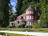
Judge Columbia Lancaster House |
|
000000001975-02-20-0000February 20, 1975
(#75001843) |
North of Ridgefield on Lancaster Road
45°51′48″N 122°44′52″W / 45.863333°N 122.747778°W / 45.863333; -122.747778 (Judge Columbia Lancaster House) |
Ridgefield |
|
| 23 |
Lewisville Park |
|
000000001986-05-28-0000May 28, 1986
(#86001202) |
26411 NE Lewisville Highway
45°49′02″N 122°32′23″W / 45.817222°N 122.539722°W / 45.817222; -122.539722 (Lewisville Park) |
Battle Ground |
|
| 24 |
Luepke Florist |
|
000000002016-05-17-0000May 17, 2016
(#16000293) |
1300 Washington Street
45°37′52″N 122°40′23″W / 45.631188°N 122.672934°W / 45.631188; -122.672934 (Luepke Florist) |
Vancouver |
|
| 25 |
Heye H. and Eva Meyer Farmstead |
|
000000002015-01-07-0000January 7, 2015
(#14001142) |
13705 NE 50th Avenue
45°43′17″N 122°37′11″W / 45.721285°N 122.619753°W / 45.721285; -122.619753 (Heye H. and Eva Meyer Farmstead) |
Vancouver |
|
| 26 |
Officers Row, Fort Vancouver Barracks |
|
000000001974-11-11-0000November 11, 1974
(#74001948) |
611–1616 E. Evergreen Boulevard
45°37′41″N 122°39′30″W / 45.628056°N 122.658333°W / 45.628056; -122.658333 (Officers Row, Fort Vancouver Barracks) |
Vancouver |
|
| 27 |
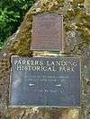
Parkersville Site |
|
000000001976-08-11-0000August 11, 1976
(#76001880) |
Address restricted[8]
|
Camas |
|
| 28 |
Pittock House |
|
000000001979-07-03-0000July 3, 1979
(#79003148) |
114 NE Leadbetter Road
45°37′21″N 122°25′42″W / 45.6225°N 122.428333°W / 45.6225; -122.428333 (Pittock House) |
Camas |
|
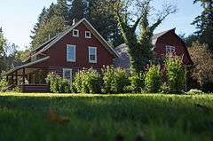
| 29 |
Pomeroy Farm |
|
000000001987-03-13-0000March 13, 1987
(#87000413) |
20902 NE Lucia Falls Road
45°50′27″N 122°27′30″W / 45.840833°N 122.458333°W / 45.840833; -122.458333 (Pomeroy Farm) |
Yacolt |
|
| 30 |
John Roffler House |
|
000000001993-04-29-0000April 29, 1993
(#93000368) |
1437 NE Everett Street
45°35′27″N 122°24′16″W / 45.590833°N 122.404444°W / 45.590833; -122.404444 (John Roffler House) |
Camas |
|
| 31 |
Sara Store |
|
000000001995-03-30-0000March 30, 1995
(#95000304) |
17903 NW 41st Avenue
45°45′24″N 122°42′41″W / 45.756667°N 122.711389°W / 45.756667; -122.711389 (Sara Store) |
Ridgefield |
|
| 32 |
William Henry Shobert House |
|
000000001979-10-04-0000October 4, 1979
(#79002528) |
621 Shobert Lane
45°48′40″N 122°44′26″W / 45.811177°N 122.740689°W / 45.811177; -122.740689 (William Henry Shobert House) |
Ridgefield |
|
| 33 |
Slocum House |
|
000000001973-01-18-0000January 18, 1973
(#73001867) |
605 Esther Street
45°38′07″N 122°40′27″W / 45.635278°N 122.674167°W / 45.635278; -122.674167 (Slocum House) |
Vancouver |
|
| 34 |
John Stanger House |
|
000000001990-05-17-0000May 17, 1990
(#90000785) |
9213 SE Evergreen Highway
45°36′24″N 122°34′42″W / 45.606554°N 122.578368°W / 45.606554; -122.578368 (John Stanger House) |
Vancouver |
|
| 35 |
U.S. National Bank Building |
|
000000001988-12-29-0000December 29, 1988
(#84004010) |
601 Main Street
45°37′34″N 122°40′13″W / 45.626111°N 122.670278°W / 45.626111; -122.670278 (U.S. National Bank Building) |
Vancouver |
|
| 36 |
U.S. Post Office – Camas Main |
|
000000001991-08-07-0000August 7, 1991
(#91000639) |
440 NE 5th Avenue
45°35′12″N 122°24′18″W / 45.586667°N 122.405°W / 45.586667; -122.405 (U.S. Post Office – Camas Main) |
Camas |
|
| 37 |
U.S. Post Office – Vancouver Main |
|
000000001991-05-30-0000May 30, 1991
(#91000659) |
1211 Daniels Street
45°37′51″N 122°40′24″W / 45.630833°N 122.673333°W / 45.630833; -122.673333 (U.S. Post Office – Vancouver Main) |
Vancouver |
|
| 38 |
Vancouver National Historic Reserve Historic District |
|
000000002007-01-05-0000January 5, 2007
(#06001216) |
Roughly bounded by an alley north of Officers Row, East Reserve Street, Columbia River, and Interstate 5
45°37′35″N 122°39′19″W / 45.626464°N 122.65533°W / 45.626464; -122.65533 (Vancouver National Historic Reserve Historic District) |
Vancouver |
|
| 39 |
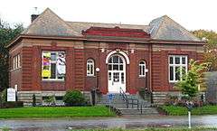
Vancouver Public Library |
|
000000001982-08-03-0000August 3, 1982
(#82004204) |
1511 Main Street
45°38′00″N 122°40′12″W / 45.633333°N 122.67°W / 45.633333; -122.67 (Vancouver Public Library) |
Vancouver |
Carnegie Libraries of Washington TR
|
| 40 |
Vancouver Telephone Building |
|
000000001986-11-06-0000November 6, 1986
(#86003092) |
112 W. 11th Street
45°37′48″N 122°40′16″W / 45.63°N 122.671111°W / 45.63; -122.671111 (Vancouver Telephone Building) |
Vancouver |
|
| 41 |
Vancouver–Portland Bridge |
|
000000001982-07-16-0000July 16, 1982
(#82004205) |
Spanning the Columbia River on Interstate 5 northbound[9]
45°37′04″N 122°40′30″W / 45.617909°N 122.675131°W / 45.617909; -122.675131 (Vancouver–Portland Bridge) |
Vancouver |
Historic Bridges and Tunnels in Washington TR
|
| 42 |
Venersborg School |
|
000000001989-03-16-0000March 16, 1989
(#89000215) |
Junction of NE 209th Street and NE 242nd Avenue
45°46′23″N 122°25′25″W / 45.773185°N 122.423599°W / 45.773185; -122.423599 (Venersborg School) |
Battle Ground vicinity |
Rural Public Schools of Washington State MPS
|
| 43 |
Washington School for the Blind |
|
000000001993-05-14-0000May 14, 1993
(#93000370) |
2214 E. 13th Street
45°38′24″N 122°38′46″W / 45.64°N 122.646111°W / 45.64; -122.646111 (Washington School for the Blind) |
Vancouver |
|
| 44 |
Yale Bridge |
|
000000001982-07-16-0000July 16, 1982
(#82004206) |
Spanning the Lewis River on State Route 503 (see also Cowlitz County)
45°57′40″N 122°22′18″W / 45.961111°N 122.371667°W / 45.961111; -122.371667 (Yale Bridge) |
Yale |
Historic Bridges and Tunnels in Washington TR |


.jpg)
.jpg)


.JPG)


.JPG)


.jpg)
 Media related to National Register of Historic Places in Clark County, Washington at Wikimedia Commons