| [3] |
Name on the Register[4] |
Image |
Date listed[5] |
Location |
City or town |
Description |
|---|
| 1 |
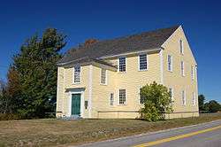
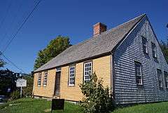
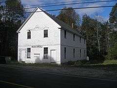
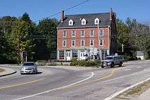
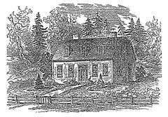
Alna Meetinghouse |
|
000000001970-05-19-0000May 19, 1970
(#70000079) |
State Route 218
44°05′14″N 69°37′06″W / 44.087222°N 69.618333°W / 44.087222; -69.618333 (Alna Meetinghouse) |
Alna Center |
|
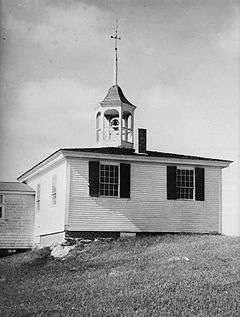
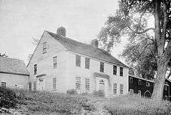
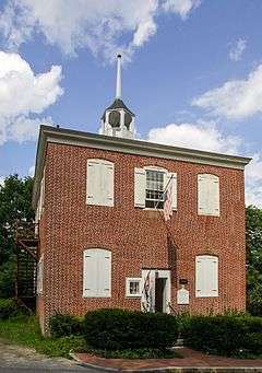
| 2 |
Alna School |
|
000000001975-04-28-0000April 28, 1975
(#75000101) |
Alna Center
44°04′56″N 69°37′08″W / 44.082222°N 69.618889°W / 44.082222; -69.618889 (Alna School) |
Alna |
|
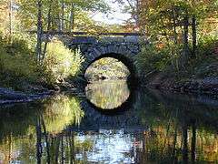
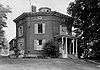
| 3 |
Arch Bridge |
|
000000002003-07-07-0000July 7, 2003
(#03000618) |
Over the Pemaquid River on Benner Rd.
43°57′44″N 69°30′35″W / 43.962222°N 69.509722°W / 43.962222; -69.509722 (Arch Bridge) |
Bristol |
|
| 4 |
Archeological Site 16.8 |
Upload image |
000000001984-06-29-0000June 29, 1984
(#84001433) |
Address Restricted
|
Boothbay |
|
| 5 |
Archeological Site 16.20 |
Upload image |
000000001984-06-29-0000June 29, 1984
(#84001456) |
Address Restricted
|
Boothbay |
|
| 6 |
Archeological Site 16.21 |
Upload image |
000000001984-06-29-0000June 29, 1984
(#84001452) |
Address Restricted
|
Boothbay |
|
| 7 |
Archeological Site 16.37 Area I and II |
Upload image |
000000001984-06-29-0000June 29, 1984
(#84001428) |
Address Restricted
|
Boothbay |
|
| 8 |
Archeological Site 16.38 |
Upload image |
000000001984-06-29-0000June 29, 1984
(#84001448) |
Address Restricted
|
Boothbay |
|
| 9 |
Archeological Site 16.47 |
Upload image |
000000001984-06-29-0000June 29, 1984
(#84001445) |
Address Restricted
|
Boothbay |
|
| 10 |
Archeological Site 16.68 |
Upload image |
000000001984-06-29-0000June 29, 1984
(#84001436) |
Address Restricted
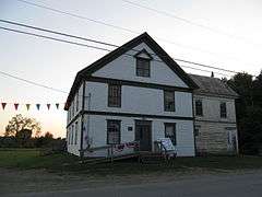
|
Boothbay |
|
| 11 |
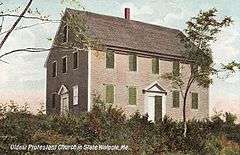
Archeological Site 16.73 |
Upload image |
000000001984-05-29-0000May 29, 1984
(#84001431) |
Address Restricted
|
Boothbay |
|
| 12 |
Archeological Site 26.27 |
Upload image |
000000001984-06-29-0000June 29, 1984
(#84001430) |
Address Restricted
|
Boothbay |
|
| 13 |
Archeological Site 16.175 |
Upload image |
000000001984-06-29-0000June 29, 1984
(#84001462) |
Address Restricted
|
Boothbay |
|
| 14 |
Archeological Site 16.198 |
Upload image |
000000001984-06-29-0000June 29, 1984
(#84001460) |
Address Restricted
|
Boothbay |
|
| 15 |
Auld-McCobb House |
|
000000001988-06-28-0000June 28, 1988
(#88000883) |
Oak St.
43°51′08″N 69°37′42″W / 43.852222°N 69.628333°W / 43.852222; -69.628333 (Auld-McCobb House) |
Boothbay Harbor |
|
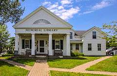
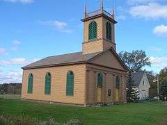
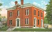
| 16 |
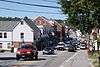
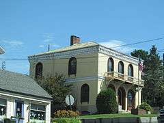
Boothbay Harbor Memorial Library |
|
000000001977-04-18-0000April 18, 1977
(#77000077) |
State Route 27
43°51′13″N 69°37′41″W / 43.853611°N 69.628056°W / 43.853611; -69.628056 (Boothbay Harbor Memorial Library) |
Boothbay Harbor |
|
| 17 |
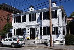
Bowman-Carney House |
|
000000001971-04-07-0000April 7, 1971
(#71000071) |
Bowman Ln., off State Route 128
44°05′45″N 69°46′23″W / 44.095784°N 69.773126°W / 44.095784; -69.773126 (Bowman-Carney House) |
Dresden |
|
| 18 |
Bremen Town Hall, Former |
Upload image |
000000002000-04-14-0000April 14, 2000
(#00000372) |
State Route 32, 0.2 miles north of Medomak Rd.
44°00′47″N 69°25′18″W / 44.013056°N 69.421667°W / 44.013056; -69.421667 (Bremen Town Hall, Former) |
Medomak |
|
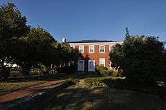
| 19 |
Brick House Historic District |
|
000000002009-02-13-0000February 13, 2009
(#09000013) |
478 River Road
44°00′19″N 69°33′27″W / 44.0052°N 69.5575°W / 44.0052; -69.5575 (Brick House Historic District) |
Newcastle |
Pre-20th century historic and archaeological listing of the Perkins Homestead.
|
| 20 |
Bridge Academy |
Upload image |
000000001987-01-09-0000January 9, 1987
(#86003540) |
44 Middle Rd.
44°06′17″N 69°43′35″W / 44.104722°N 69.726389°W / 44.104722; -69.726389 (Bridge Academy) |
Dresden |
Now houses the local public library.
|
| 21 |
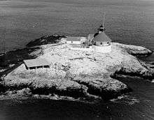
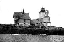
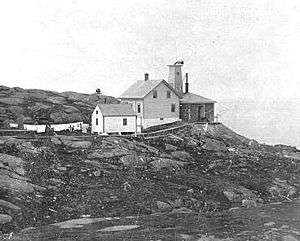
Burnt Island Light Station |
|
000000001977-11-23-0000November 23, 1977
(#77000139) |
South of Boothbay Harbor on Burnt Island
43°49′30″N 69°38′25″W / 43.8251°N 69.6402°W / 43.8251; -69.6402 (Burnt Island Light Station) |
Boothbay Harbor |
|
| 22 |
Moses Carleton House |
Upload image |
000000002002-07-18-0000July 18, 2002
(#02000783) |
Hollywood Boulevard 0.2 miles northeast of its junction with State Route 94
44°06′47″N 69°36′40″W / 44.113056°N 69.611111°W / 44.113056; -69.611111 (Moses Carleton House) |
Alna |
|
| 23 |
Chapman-Hall House |
|
000000001970-05-19-0000May 19, 1970
(#70000077) |
Main and Vine Sts.
44°01′57″N 69°31′47″W / 44.0325°N 69.529722°W / 44.0325; -69.529722 (Chapman-Hall House) |
Damariscotta |
|
| 24 |
Chimney Farm |
Upload image |
000000002007-02-07-0000February 7, 2007
(#07000012) |
617 East Neck Rd.
44°06′57″N 69°28′31″W / 44.115788°N 69.475241°W / 44.115788; -69.475241 (Chimney Farm) |
Nobleboro |
|
| 25 |
Clary Mill |
Upload image |
000000002004-12-02-0000December 2, 2004
(#04001283) |
104 Mills Rd.
44°13′42″N 69°35′03″W / 44.228333°N 69.584167°W / 44.228333; -69.584167 (Clary Mill) |
Whitefield |
|
| 26 |
Stephen Coffin House |
|
000000001987-04-15-0000April 15, 1987
(#86003519) |
Main St.
44°01′57″N 69°31′53″W / 44.0325°N 69.531389°W / 44.0325; -69.531389 (Stephen Coffin House) |
Damariscotta |
|
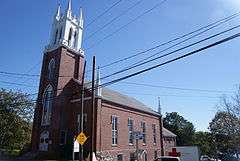
| 27 |
Congregational Church of Edgecomb |
Upload image |
000000001987-06-12-0000June 12, 1987
(#87000923) |
Cross Point Rd.
43°59′07″N 69°38′47″W / 43.985278°N 69.646389°W / 43.985278; -69.646389 (Congregational Church of Edgecomb) |
North Edgecomb |
|
| 28 |
CORA F. CRESSEY |
|
000000001990-04-18-0000April 18, 1990
(#90000586) |
Keene Narrows
43°59′04″N 69°24′54″W / 43.984444°N 69.415°W / 43.984444; -69.415 (CORA F. CRESSEY) |
Bremen |
|
| 29 |
Cottage on King's Row |
Upload image |
000000002016-01-12-0000January 12, 2016
(#15000970) |
1400 ME 32
43°56′42″N 69°27′46″W / 43.945059°N 69.462888°W / 43.945059; -69.462888 (Cottage on King's Row) |
Bristol |
|
| 30 |
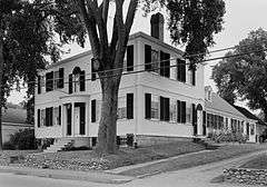
Matthew Cottrill House |
|
000000001974-05-02-0000May 2, 1974
(#74000177) |
Main St. (U.S. Route 1)
44°01′50″N 69°32′06″W / 44.030556°N 69.535°W / 44.030556; -69.535 (Matthew Cottrill House) |
Damariscotta |
|
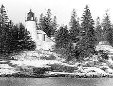
| 31 |
Cuckolds Light Station |
|
000000002002-12-02-0000December 2, 2002
(#02001413) |
The Cuckolds
43°46′46″N 69°39′03″W / 43.779444°N 69.650833°W / 43.779444; -69.650833 (Cuckolds Light Station) |
Southport |
|
| 32 |
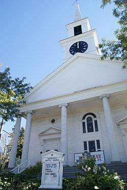
Damariscotta Baptist Church |
|
000000001985-06-20-0000June 20, 1985
(#85001265) |
King's Square
44°01′53″N 69°31′47″W / 44.031389°N 69.529722°W / 44.031389; -69.529722 (Damariscotta Baptist Church) |
Damariscotta |
|
| 33 |
Damariscotta Oyster Shell Heaps |
|
000000001969-12-30-0000December 30, 1969
(#69000027) |
East and west banks of the Damariscotta River
44°02′31″N 69°30′47″W / 44.042°N 69.513°W / 44.042; -69.513 (Damariscotta Oyster Shell Heaps) |
Damariscotta |
Includes the Whaleback Shell Midden (now a state historic site) and the Glidden Shell Midden.
|
| 34 |
Damariscotta Shell Midden Historic District |
|
000000001998-10-08-0000October 8, 1998
(#98001238) |
Along the Damariscotta River
44°02′34″N 69°30′54″W / 44.0429°N 69.5150°W / 44.0429; -69.5150 (Damariscotta Shell Midden Historic District) |
Damariscotta |
Includes 10 shell middens (including Whaleback and Glidden), and one non-midden prehistoric archaeological site.
|
| 35 |
Damariscove Island Archeological Site |
Upload image |
000000001978-05-22-0000May 22, 1978
(#78000186) |
Damariscove Island
43°45′55″N 69°36′45″W / 43.765278°N 69.6125°W / 43.765278; -69.6125 (Damariscove Island Archeological Site) |
Boothbay |
Most of the island is archaeologically sensitive.
|
| 36 |
Damariscove Lifesaving Station |
Upload image |
000000001987-06-25-0000June 25, 1987
(#87000924) |
Damariscove Island
43°45′17″N 69°36′58″W / 43.754722°N 69.616111°W / 43.754722; -69.616111 (Damariscove Lifesaving Station) |
Boothbay |
|
| 37 |
Dodge Point Site |
Upload image |
000000001991-03-22-0000March 22, 1991
(#91000319) |
Address Restricted
|
Newcastle |
|
| 38 |
Dresden Brick School House |
Upload image |
000000001986-06-13-0000June 13, 1986
(#86001273) |
State Route 128
44°05′07″N 69°46′26″W / 44.085196°N 69.773886°W / 44.085196; -69.773886 (Dresden Brick School House) |
Dresden |
|
| 39 |
Dresden Town House |
|
000000002000-10-12-0000October 12, 2000
(#00001204) |
391 Middle Rd.
44°05′08″N 69°44′37″W / 44.085556°N 69.743611°W / 44.085556; -69.743611 (Dresden Town House) |
Dresden Mills |
|
| 40 |
Fisherman's Island |
Upload image |
000000002014-12-29-0000December 29, 2014
(#14001091) |
Address Restricted
43°47′54″N 69°36′11″W / 43.7983°N 69.6031°W / 43.7983; -69.6031 (Fisherman's Island) |
Boothbay |
|
| 41 |
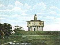
Fort Edgecomb |
|
000000001969-10-01-0000October 1, 1969
(#69000020) |
On Davis Island in the Sheepscot River
43°59′37″N 69°39′26″W / 43.993611°N 69.657222°W / 43.993611; -69.657222 (Fort Edgecomb) |
Edgecomb |
Boundary increase December 22, 1991.
|
| 42 |
Fort William Henry |
|
000000001969-12-01-0000December 1, 1969
(#69000021) |
Northwest of Pemaquid Beach
43°52′39″N 69°31′29″W / 43.8775°N 69.524722°W / 43.8775; -69.524722 (Fort William Henry) |
Pemaquid Beach |
|
| 43 |
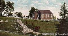
German Church and Cemetery |
|
000000001970-05-19-0000May 19, 1970
(#70000050) |
1 mile south of Waldoboro Village on State Route 32
44°06′08″N 69°25′17″W / 44.102222°N 69.421389°W / 44.102222; -69.421389 (German Church and Cemetery) |
Waldoboro |
|
| 44 |
Glidden-Austin Block |
|
000000001975-04-28-0000April 28, 1975
(#75000102) |
Junction of U.S. Route 1 and State Route 215
44°02′07″N 69°32′15″W / 44.035278°N 69.5375°W / 44.035278; -69.5375 (Glidden-Austin Block) |
Newcastle |
|
| 45 |
Old Gray House |
Upload image |
000000002007-05-08-0000May 8, 2007
(#07000408) |
60 Tavenner Rd.
43°52′27″N 69°40′51″W / 43.874167°N 69.680833°W / 43.874167; -69.680833 (Old Gray House) |
Boothbay |
|
| 46 |
Harrington Meetinghouse |
|
000000001970-05-19-0000May 19, 1970
(#70000051) |
Northwest of Pemaquid on Old Harrington Rd.
43°54′53″N 69°31′43″W / 43.914722°N 69.528611°W / 43.914722; -69.528611 (Harrington Meetinghouse) |
Pemaquid |
1772 meeting house originally stood in Bristol Mills, frame taken down and reerected, building moved to present location and altered into a reverse plan and then mostly restored in 1960-1970. One of three meeting houses built at the same time in Bristol.
|
| 47 |
Head Tide Historic District |
|
000000001974-11-19-0000November 19, 1974
(#74000320) |
Both sides of the Sheepscot River
44°06′53″N 69°37′28″W / 44.114722°N 69.624444°W / 44.114722; -69.624444 (Head Tide Historic District) |
Alna |
|
| 48 |
Hendricks Head Light Station |
|
000000001987-11-20-0000November 20, 1987
(#87002024) |
Hendricks Head on Southport Island
43°49′21″N 69°41′25″W / 43.8225°N 69.690278°W / 43.8225; -69.690278 (Hendricks Head Light Station) |
West Southport |
|
| 49 |
Anne Hilton Site |
Upload image |
000000001989-07-13-0000July 13, 1989
(#89000838) |
Address Restricted
|
Newcastle |
|
| 50 |
Huston House |
Upload image |
000000001985-02-08-0000February 8, 1985
(#85000241) |
Bristol Rd.
44°01′04″N 69°31′49″W / 44.017778°N 69.530278°W / 44.017778; -69.530278 (Huston House) |
Damariscotta |
|
| 51 |
Hutchins House |
Upload image |
000000001982-02-19-0000February 19, 1982
(#82000769) |
77 Main St.
44°05′46″N 69°22′26″W / 44.096111°N 69.373889°W / 44.096111; -69.373889 (Hutchins House) |
Waldoboro |
|
| 52 |
The Influence |
|
000000001983-12-29-0000December 29, 1983
(#83003655) |
Main Street, Monhegan Island
43°45′49″N 69°19′17″W / 43.763611°N 69.321389°W / 43.763611; -69.321389 (The Influence) |
Monhegan |
|
| 53 |
Dr. F.W. Jackson House |
Upload image |
000000001980-11-10-0000November 10, 1980
(#80000236) |
State Route 32
44°12′09″N 69°27′50″W / 44.2025°N 69.463889°W / 44.2025; -69.463889 (Dr. F.W. Jackson House) |
Jefferson |
|
| 54 |
Jefferson Cattle Pound |
Upload image |
000000002004-07-28-0000July 28, 2004
(#04000742) |
0.75 miles west of the junction of Gardiner Rd. and State Route 213
44°12′01″N 69°29′48″W / 44.200278°N 69.496667°W / 44.200278; -69.496667 (Jefferson Cattle Pound) |
Jefferson |
|
| 55 |
Jefferson Town House |
Upload image |
000000001999-07-12-0000July 12, 1999
(#99000771) |
Junction of State Routes 126 and 213
44°12′02″N 69°29′06″W / 44.200556°N 69.485°W / 44.200556; -69.485 (Jefferson Town House) |
Jefferson |
|
| 56 |
Gov. Edward Kavanaugh House |
|
000000001974-05-03-0000May 3, 1974
(#74000178) |
State Route 215 (Damariscotta Mills)
44°03′39″N 69°31′51″W / 44.0608°N 69.5308°W / 44.0608; -69.5308 (Gov. Edward Kavanaugh House) |
Newcastle |
|
| 57 |
Rockwell Kent Cottage and Studio |
Upload image |
000000001992-04-08-0000April 8, 1992
(#92000278) |
Off the northern side of Horn Hill Rd. on Monhegan Island
43°45′47″N 69°19′08″W / 43.763056°N 69.318889°W / 43.763056; -69.318889 (Rockwell Kent Cottage and Studio) |
Monhegan |
|
| 58 |
Knight-Corey House |
Upload image |
000000001980-03-13-0000March 13, 1980
(#80000237) |
Corey Lane
43°52′35″N 69°38′09″W / 43.876389°N 69.635833°W / 43.876389; -69.635833 (Knight-Corey House) |
Boothbay |
|
| 59 |
Lithgow House |
Upload image |
000000001985-12-26-0000December 26, 1985
(#85003156) |
Blinn Hill Rd.
44°06′36″N 69°43′05″W / 44.11°N 69.718056°W / 44.11; -69.718056 (Lithgow House) |
Dresden |
|
| 60 |
Loudville Church |
Upload image |
000000001995-12-14-0000December 14, 1995
(#95001457) |
Center of Louds Island
43°55′49″N 69°26′07″W / 43.930278°N 69.435278°W / 43.930278; -69.435278 (Loudville Church) |
Loudville |
|
| 61 |
Godfrey Ludwig House |
Upload image |
000000001980-09-22-0000September 22, 1980
(#80000238) |
State Route 32
44°09′33″N 69°25′00″W / 44.159167°N 69.416667°W / 44.159167; -69.416667 (Godfrey Ludwig House) |
Waldoboro |
|
| 62 |
Main Street Historic District |
|
000000001979-08-10-0000August 10, 1979
(#79000154) |
Main St.; also 170-270 Main St. and 4-5 Bristol Rd.
44°01′58″N 69°31′56″W / 44.032778°N 69.532222°W / 44.032778; -69.532222 (Main Street Historic District) |
Damariscotta |
Second set of addresses represents a boundary increase
|
| 63 |
Manana Island Fog Signal Station |
|
000000002002-12-02-0000December 2, 2002
(#02001412) |
Manana Island
43°45′54″N 69°19′37″W / 43.765°N 69.326944°W / 43.765; -69.326944 (Manana Island Fog Signal Station) |
Monhegan |
|
| 64 |
Emily Means House |
Upload image |
000000001985-02-08-0000February 8, 1985
(#85000242) |
Birch Island
43°50′58″N 69°32′57″W / 43.849444°N 69.549167°W / 43.849444; -69.549167 (Emily Means House) |
South Bristol |
|
| 65 |
Monhegan Island Lighthouse and Quarters |
|
000000001980-05-07-0000May 7, 1980
(#80000239) |
Monhegan Island
43°45′54″N 69°19′00″W / 43.765°N 69.316667°W / 43.765; -69.316667 (Monhegan Island Lighthouse and Quarters) |
Monhegan |
|
| 66 |
John Moore House |
Upload image |
000000001979-07-10-0000July 10, 1979
(#79000155) |
Southwest of Edgecomb on Cross Point Rd.
43°58′35″N 69°38′55″W / 43.976262°N 69.648612°W / 43.976262; -69.648612 (John Moore House) |
Edgecomb |
|
| 67 |
Nahanada Village Site |
Upload image |
000000001980-07-22-0000July 22, 1980
(#80000240) |
Address Restricted
|
Bristol |
|
| 68 |
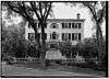
Nickels-Sortwell House |
|
000000001970-12-30-0000December 30, 1970
(#70000078) |
Northeastern corner of Main and Federal Sts.
44°00′15″N 69°40′03″W / 44.004167°N 69.6675°W / 44.004167; -69.6675 (Nickels-Sortwell House) |
Wiscasset |
|
| 69 |
Parson's Bend |
Upload image |
000000002005-12-21-0000December 21, 2005
(#05001439) |
100 Nelson Rd.
44°05′55″N 69°36′00″W / 44.098611°N 69.6°W / 44.098611; -69.6 (Parson's Bend) |
Alna |
|
| 70 |
Josiah K. Parsons Homestead |
Upload image |
000000001982-02-04-0000February 4, 1982
(#82000770) |
Greenleaf Cove Rd.
43°55′12″N 69°41′35″W / 43.92°N 69.693056°W / 43.92; -69.693056 (Josiah K. Parsons Homestead) |
Westport |
Listed as being in the Wiscasset vicinity
|
| 71 |
Stephen Parsons House |
Upload image |
000000001983-10-06-0000October 6, 1983
(#83003648) |
Southwest of Edgecomb on Parsons Creek
43°56′55″N 69°38′38″W / 43.948611°N 69.643889°W / 43.948611; -69.643889 (Stephen Parsons House) |
Edgecomb |
|
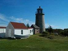
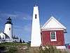
| 72 |
Pemaquid Point Light |
|
000000001985-04-16-0000April 16, 1985
(#85000843) |
Pemaquid Point
43°50′13″N 69°30′23″W / 43.836944°N 69.506389°W / 43.836944; -69.506389 (Pemaquid Point Light) |
Bristol |
|
| 73 |
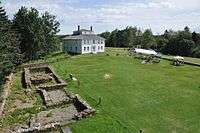
Pemaquid Restoration and Museum |
|
000000001969-12-02-0000December 2, 1969
(#69000022) |
North of Pemaquid Beach at Pemaquid Point
43°52′41″N 69°31′17″W / 43.878056°N 69.521389°W / 43.878056; -69.521389 (Pemaquid Restoration and Museum) |
Pemaquid Beach |
|
| 74 |
Perkins Homestead |
|
000000002014-08-25-0000August 25, 2014
(#14000919) |
478 River Rd.
44°00′19″N 69°33′27″W / 44.0052°N 69.5575°W / 44.0052; -69.5575 (Perkins Homestead) |
Newcastle |
Homestead associated with Frances Perkins, the first female United States Cabinet member; also listed as the "Brick House Historic District" for earlier significance.
|
| 75 |
Pownalborough Courthouse |
|
000000001970-01-12-0000January 12, 1970
(#70000052) |
Cedar Grove Rd.
44°06′19″N 69°45′59″W / 44.105278°N 69.766389°W / 44.105278; -69.766389 (Pownalborough Courthouse) |
Dresden |
|
| 76 |
Pythian Opera House |
|
000000002008-12-30-0000December 30, 2008
(#08001256) |
86 Townsend Ave.
43°51′16″N 69°37′35″W / 43.85431°N 69.62626°W / 43.85431; -69.62626 (Pythian Opera House) |
Boothbay Harbor |
|
| 77 |
Ram Island Light Station |
|
000000001988-01-21-0000January 21, 1988
(#87002280) |
Ram Island, Boothbay Harbor
43°48′14″N 69°36′00″W / 43.803889°N 69.6°W / 43.803889; -69.6 (Ram Island Light Station) |
Boothbay Harbor |
|
| 78 |
Red Brick School |
|
000000001970-10-06-0000October 6, 1970
(#70000089) |
Warren St.
44°00′19″N 69°40′00″W / 44.005278°N 69.666667°W / 44.005278; -69.666667 (Red Brick School) |
Wiscasset |
|
| 79 |
Col. Isaac G. Reed House |
Upload image |
000000002005-08-05-0000August 5, 2005
(#05000796) |
60 Glidden St.
44°05′49″N 69°22′38″W / 44.096944°N 69.377222°W / 44.096944; -69.377222 (Col. Isaac G. Reed House) |
Waldoboro |
|
| 80 |
Capt. George Scott House |
|
000000001972-02-23-0000February 23, 1972
(#72000104) |
Federal St.
44°00′26″N 69°39′49″W / 44.007221°N 69.663499°W / 44.007221; -69.663499 (Capt. George Scott House) |
Wiscasset |
|
| 81 |
Second Congregational Church |
|
000000001979-05-07-0000May 7, 1979
(#79000156) |
River St.
44°02′04″N 69°32′15″W / 44.034444°N 69.5375°W / 44.034444; -69.5375 (Second Congregational Church) |
Newcastle |
|
| 82 |
Sheepscot Historic District |
Upload image |
000000001978-06-23-0000June 23, 1978
(#78000424) |
Sheepscot Rd. and Kings Hwy.
44°03′00″N 69°36′35″W / 44.04995°N 69.6096°W / 44.04995; -69.6096 (Sheepscot Historic District) |
Newcastle and Alna |
|
| 83 |
Sproul Homestead |
Upload image |
000000001978-03-21-0000March 21, 1978
(#78000188) |
North of South Bristol on State Route 129
43°54′30″N 69°33′11″W / 43.908333°N 69.553056°W / 43.908333; -69.553056 (Sproul Homestead) |
South Bristol |
|
| 84 |
Sprucewold Lodge |
Upload image |
000000002014-10-08-0000October 8, 2014
(#14000837) |
4-9 Nahanada Road
43°50′27″N 69°37′12″W / 43.8408°N 69.6199°W / 43.8408; -69.6199 (Sprucewold Lodge) |
Boothbay Harbor |
|
| 85 |
Squire Tarbox House |
Upload image |
000000001985-04-11-0000April 11, 1985
(#85000725) |
State Route 144
43°54′05″N 69°42′30″W / 43.901389°N 69.708333°W / 43.901389; -69.708333 (Squire Tarbox House) |
Westport |
|
| 86 |
St. Andrew's Church |
|
000000001976-10-08-0000October 8, 1976
(#76000101) |
Glidden St.
44°02′03″N 69°32′04″W / 44.034167°N 69.534444°W / 44.034167; -69.534444 (St. Andrew's Church) |
Newcastle |
|
| 87 |
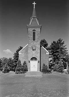
St. Denis Catholic Church |
Upload image |
000000001976-10-29-0000October 29, 1976
(#76000102) |
298 State Route 126
44°13′43″N 69°36′52″W / 44.228611°N 69.614444°W / 44.228611; -69.614444 (St. Denis Catholic Church) |
North Whitefield |
|
| 88 |
St. John's Anglican Church and Parsonage Site |
|
000000001978-11-21-0000November 21, 1978
(#78000187) |
Address Restricted
|
Dresden |
|
| 89 |
St. John's Episcopal Church |
|
000000001991-06-14-0000June 14, 1991
(#91000769) |
Southern side of State Route 27 at its junction with Blinn Hill Rd.
44°06′24″N 69°43′25″W / 44.106667°N 69.723611°W / 44.106667; -69.723611 (St. John's Episcopal Church) |
Dresden Mills |
|
| 90 |
St. Patrick's Catholic Church |
|
000000001973-04-23-0000April 23, 1973
(#73000133) |
Academy Rd.
44°03′25″N 69°32′07″W / 44.056944°N 69.535278°W / 44.056944; -69.535278 (St. Patrick's Catholic Church) |
Newcastle |
|
| 91 |
Taylor Site 16.65 |
Upload image |
000000001984-06-29-0000June 29, 1984
(#84001441) |
Address Restricted
|
Boothbay |
|
| 92 |
Thompson Icehouse |
Upload image |
000000001974-12-31-0000December 31, 1974
(#74000179) |
State Route 129
43°52′44″N 69°33′38″W / 43.878957°N 69.560522°W / 43.878957; -69.560522 (Thompson Icehouse) |
South Bristol |
|
| 93 |
U.S. Customhouse (Old Customhouse) and Post Office |
|
000000001970-08-25-0000August 25, 1970
(#70000053) |
Water St.
44°00′03″N 69°39′58″W / 44.000833°N 69.666111°W / 44.000833; -69.666111 (U.S. Customhouse (Old Customhouse) and Post Office) |
Wiscasset |
|
| 94 |
U.S. Customhouse and Post Office |
|
000000001974-01-18-0000January 18, 1974
(#74000180) |
Main St.
44°05′44″N 69°22′33″W / 44.095556°N 69.375833°W / 44.095556; -69.375833 (U.S. Customhouse and Post Office) |
Waldoboro |
|
| 95 |
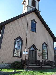
Union Church |
|
000000001998-06-26-0000June 26, 1998
(#98000723) |
Eastern side of State Route 32, 0.05 miles south of its junction with Back Shore Rd.
43°56′49″N 69°27′40″W / 43.946944°N 69.461111°W / 43.946944; -69.461111 (Union Church) |
Round Pond |
|
| 96 |
Union Meeting House, (Former) |
Upload image |
000000002002-07-15-0000July 15, 2002
(#02000786) |
Main Rd., State Route 144
43°53′55″N 69°42′34″W / 43.898611°N 69.709444°W / 43.898611; -69.709444 (Union Meeting House, (Former)) |
Westport |
|
| 97 |
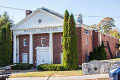
Waldo Theatre |
|
000000001986-09-11-0000September 11, 1986
(#86002434) |
Main St.
44°05′45″N 69°22′30″W / 44.095833°N 69.375°W / 44.095833; -69.375 (Waldo Theatre) |
Waldoboro |
|
| 98 |
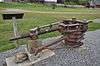
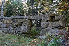
Waldoborough Town Pound |
|
000000001976-05-28-0000May 28, 1976
(#76000103) |
Main St.
44°06′05″N 69°22′12″W / 44.101382°N 69.369970°W / 44.101382; -69.369970 (Waldoborough Town Pound) |
Waldoboro |
|
| 99 |
Walpole Meetinghouse |
|
000000001976-11-07-0000November 7, 1976
(#76000104) |
North of Walpole on Meeting House Rd.
43°59′09″N 69°32′28″W / 43.985833°N 69.541111°W / 43.985833; -69.541111 (Walpole Meetinghouse) |
Walpole |
|
| 100 |
Daniel Weston Homestead |
Upload image |
000000001979-10-01-0000October 1, 1979
(#79000157) |
West of Medomak on State Route 32
44°00′06″N 69°25′43″W / 44.001667°N 69.428611°W / 44.001667; -69.428611 (Daniel Weston Homestead) |
Medomak |
|
| 101 |
Westport Community Church |
Upload image |
000000002002-07-15-0000July 15, 2002
(#02000784) |
Main Rd., State Route 144
43°53′57″N 69°42′34″W / 43.899167°N 69.709444°W / 43.899167; -69.709444 (Westport Community Church) |
Westport |
|
| 102 |
Wetherill Site |
Upload image |
000000001992-12-17-0000December 17, 1992
(#92001709) |
Address Restricted
|
Waldoboro |
|
| 103 |
Whitefield Union Hall |
|
000000002007-02-07-0000February 7, 2007
(#07000014) |
901 Townhouse Rd.
44°10′15″N 69°37′41″W / 44.170833°N 69.628056°W / 44.170833; -69.628056 (Whitefield Union Hall) |
Whitefield |
|
| 104 |
Wiscasset Historic District |
|
000000001973-01-12-0000January 12, 1973
(#73000242) |
Roughly Parker, Dresden, Bradford, Main, and Federal Sts.
44°00′20″N 69°40′04″W / 44.005556°N 69.667778°W / 44.005556; -69.667778 (Wiscasset Historic District) |
Wiscasset |
|
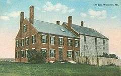
| 105 |
Wiscasset Jail and Museum |
|
000000001970-01-26-0000January 26, 1970
(#70000054) |
State Route 218
44°00′38″N 69°39′44″W / 44.010556°N 69.662222°W / 44.010556; -69.662222 (Wiscasset Jail and Museum) |
Wiscasset |
|