Netrokona District
| Netrokona নেত্রকোনা | |
|---|---|
| District | |
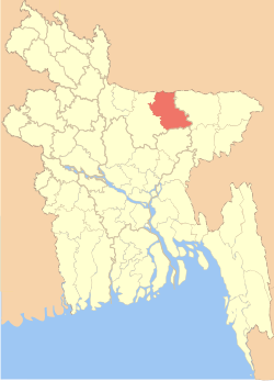 Location of Netrokona in Bangladesh | |
| Coordinates: BD 24°53′N 90°44′E / 24.88°N 90.73°ECoordinates: BD 24°53′N 90°44′E / 24.88°N 90.73°E | |
| Country |
|
| Division | Mymensingh Division |
| Area | |
| • Total | 2,794.28 km2 (1,078.88 sq mi) |
| Population (2011 census) | |
| • Total | 2,229,642 |
| • Density | 800/km2 (2,100/sq mi) |
| Time zone | BST (UTC+6) |
Netrakona (Bengali: নেত্রকোনা) is a district in northern Bangladesh. It is a part of Mymensingh Division.
Geography
Netrakona is situated in the northern part of Bangladesh, near the Meghalayan border. There are four main rivers in Netrakona: Kangsha, Dhala, Magra, and Teorkhali.
Netrakona Pouroshabha (Town of Netrakona) is a municipal town, established in 1887 and with an area of 13.63 km².
Upazillas
Netrokona district is divided into ten upazillas.[1]
- Atpara Upazila
- Barhatta Upazila
- Durgapur Upazila
- Khaliajuri Upazila
- Kalmakanda Upazila
- Kendua Upazila
- Madan Upazila
- Mohanganj Upazila
- Netrokona Sadar Upazila
- Purbadhala Upazila
Economy
The economy of Netrakona is largely agrarian. Susang Durgapur, an Upazila of Netrakona, is one of the major sources of country's China-Clay used for ceramic products. Its vast water bodies (Hawor) provides wide varieties of fishes. Bara Bazar is commerce centre of Netrakona.
Tourist Attractions
- Birishiri: This is one of the beautiful places of Bangladesh. There is a hill of white clay.
- Hawor : Hawor is a large area of water spaces.
- Madanpur Mazar (Shah Sultan Rumi): It is situated 8 km south to the Netrakona Town.
- Ranikong Mission
Religion
The district of Netrakona consists 3146 mosques, 958 temples, 83 churches and eight Buddhist temples.
See also
References
| Wikimedia Commons has media related to Netrokona District. |
- ↑ Sanjay Sarkar (2012). "Netrokona District". In Sirajul Islam and Ahmed A. Jamal. Banglapedia: National Encyclopedia of Bangladesh (Second ed.). Asiatic Society of Bangladesh.
External links
| Barisal Division |  | |
|---|---|---|
| Chittagong Division | ||
| Dhaka Division | ||
| Khulna Division | ||
| Mymensingh Division | ||
| Rajshahi Division | ||
| Rangpur Division | ||
| Sylhet Division | ||