Queen Anne's County, Maryland
| Queen Anne's County, Maryland | ||
|---|---|---|
|
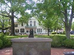
Queen Anne's County Courthouse | ||
| ||
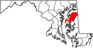 Location in the U.S. state of Maryland | ||
 Maryland's location in the U.S. | ||
| Founded | 1706 | |
| Named for | Queen Anne | |
| Seat | Centreville | |
| Largest community | Stevensville | |
| Area | ||
| • Total | 511 sq mi (1,323 km2) | |
| • Land | 372 sq mi (963 km2) | |
| • Water | 139 sq mi (360 km2), 27% | |
| Population (est.) | ||
| • (2015) | 48,904 | |
| • Density | 96/sq mi (37/km²) | |
| Congressional district | 1st | |
| Time zone | Eastern: UTC-5/-4 | |
| Website |
www | |

Queen Anne's County is a county located in the U.S. state of Maryland. As of the 2010 census, the population was 47,798.[1] Its county seat and most populous municipality is Centreville.[2] The census-designated place of Stevensville is the county's most populous place. The county is named for Queen Anne of Great Britain who reigned when the county was established in 1706.
Queen Anne's County is included in the Baltimore-Columbia-Towson, MD Metropolitan Statistical Area, which is also included in the Washington-Baltimore-Arlington, DC-MD-VA-WV-PA Combined Statistical Area. The Chesapeake Bay Bridge connects Queen Anne's of the Eastern Shore to Anne Arundel County on the Western Shore.
History
Queen Anne's County has two hundred sixty-five miles of waterfront area, much of that being the shores of Kent Island, which stands out from the eastern shore of the Chesapeake Bay. From the waters of this county, watermen have brought oysters, crabs, and terrapin. Migrating waterfowl overwinter here, and hunting for geese and ducks has been an important part of the county's history. The first settlement in Maryland was on Kent Island in August 21, 1631, and included twenty-five settlers in a manor house, a fort, and other buildings. The settlement was referred to as Winston's Island. The first houses were built similar to log cabins. Although the county has a number of properties on the National Register of Historic Places,[3] the original settlement no longer exists. One of the oldest towns still existing is Stevensville, earlier known as Broad Creek.
Queen Anne's County was organized under a sheriff in 1706, bounded by Talbot, Kent, and Dorchester Counties. In 1713, Queen Anne's County became an English postal district where the sheriff was the postmaster and would travel to Annapolis by boat to obtain mail. In 1773 a part of Queen Anne's County, together with a portion of Dorchester County, was taken to form Caroline County. The county now is enclosed by Talbot, Caroline, and Kent County as well as the Chesapeake Bay.
By the time of Independence, the county had several churches, a government, school, and a postal system.
In 1876, Queen Anne's County had the first printed independent paper called the Maryland Citizen, and a bank, located in Centreville; the Centreville National Bank exists to this day. When the Railroad Company was finished in 1868 it operated from Baltimore around the top of the Chesapeake Bay down to Queenstown, and connected with other railroads that continued east into[4] Delaware as far as Rehoboth, and southward to the Eastern Shore of Virginia.
In the 20th century, Queen Anne's County was the home of baseball Hall of Famer Jimmie Foxx. There is a statue and small park in Sudlersville, where Foxx grew up.
Law and government
Queen Anne's County was granted home rule in 1990 under a state code.
Queen Anne's County has a Commission form of government. The Commission consists of five elected Commissioners who are elected at large by the general population and each must reside in the district they represent: one of the four Commission districts. The fifth commissioner serves as President the first year. County Code allows for rotation of the President position thereafter.
The current Board of Commissioners was elected in the 2014 election, and serve a four-year term.. The current form of five Commissioners elected at large started in 2002.Prior to the 2002 election Queen Anne's County was run by three Commissioners.
Geography
According to the U.S. Census Bureau, the county has a total area of 511 square miles (1,320 km2), of which 372 square miles (960 km2) is land and 139 square miles (360 km2) (27%) is water.[5]
Adjacent counties
- Kent County (north)
- Kent County, Delaware (east)
- Talbot County (south)
- Caroline County (southeast)
- Anne Arundel County (west)
Demographics
| Historical population | |||
|---|---|---|---|
| Census | Pop. | %± | |
| 1790 | 15,463 | — | |
| 1800 | 14,857 | −3.9% | |
| 1810 | 16,648 | 12.1% | |
| 1820 | 14,952 | −10.2% | |
| 1830 | 14,397 | −3.7% | |
| 1840 | 12,633 | −12.3% | |
| 1850 | 14,484 | 14.7% | |
| 1860 | 15,961 | 10.2% | |
| 1870 | 16,171 | 1.3% | |
| 1880 | 19,257 | 19.1% | |
| 1890 | 18,461 | −4.1% | |
| 1900 | 18,364 | −0.5% | |
| 1910 | 16,839 | −8.3% | |
| 1920 | 16,001 | −5.0% | |
| 1930 | 14,571 | −8.9% | |
| 1940 | 14,476 | −0.7% | |
| 1950 | 14,579 | 0.7% | |
| 1960 | 16,569 | 13.6% | |
| 1970 | 18,422 | 11.2% | |
| 1980 | 25,508 | 38.5% | |
| 1990 | 33,953 | 33.1% | |
| 2000 | 40,563 | 19.5% | |
| 2010 | 47,798 | 17.8% | |
| Est. 2015 | 48,904 | [6] | 2.3% |
| U.S. Decennial Census[7] 1790-1960[8] 1900-1990[9] 1990-2000[10] 2010-2015[1] | |||
2000 census
As of the census[11] of 2000, there were 40,563 people, 15,315 households, and 11,547 families residing in the county. The population density was 109 people per square mile (42/km²). There were 16,674 housing units at an average density of 45 per square mile (17/km²). The racial makeup of the county was 89.05% White, 8.78% Black or African American, 0.22% Native American, 0.57% Asian, 0.02% Pacific Islander, 0.43% from other races, and 0.93% from two or more races. 1.09% of the population were Hispanic or Latino of any race. 16.9% were of German, 15.1% American, 14.6% English, 14.2% Irish and 5.3% Italian ancestry.
There were 15,315 households out of which 33.30% had children under the age of 18 living with them, 62.20% were married couples living together, 9.50% had a female householder with no husband present, and 24.60% were non-families. 19.60% of all households were made up of individuals and 7.90% had someone living alone who was 65 years of age or older. The average household size was 2.62 and the average family size was 2.99.
In the county, the population was spread out with 25.40% under the age of 18, 5.80% from 18 to 24, 30.10% from 25 to 44, 25.90% from 45 to 64, and 12.90% who were 65 years of age or older. The median age was 39 years. For every 100 females, there were 99.20 males. For every 100 females age 18 and over, there were 96.80 males.
The median income for a household in the county was $57,037, and the median income for a family was $63,713. Males had a median income of $44,644 versus $30,144 for females. The per capita income for the county was $26,364. About 4.40% of families and 6.30% of the population were below the poverty line, including 7.20% of those under age 18 and 7.30% of those age 65 or over.
2010 census
As of the 2010 United States Census, there were 47,798 people, 18,016 households, and 13,314 families residing in the county.[12] The population density was 128.5 inhabitants per square mile (49.6/km2). There were 20,140 housing units at an average density of 54.2 per square mile (20.9/km2).[13] The racial makeup of the county was 88.7% white, 6.9% black or African American, 1.0% Asian, 0.3% American Indian, 1.4% from other races, and 1.7% from two or more races. Those of Hispanic or Latino origin made up 3.0% of the population.[12] In terms of ancestry, 25.9% were German, 22.4% were Irish, 15.8% were English, 6.2% were Italian, and 6.1% were American.[14]
Of the 18,016 households, 34.4% had children under the age of 18 living with them, 60.3% were married couples living together, 9.2% had a female householder with no husband present, 26.1% were non-families, and 20.6% of all households were made up of individuals. The average household size was 2.63 and the average family size was 3.04. The median age was 42.6 years.[12]
The median income for a household in the county was $81,096 and the median income for a family was $89,188. Males had a median income of $57,218 versus $43,371 for females. The per capita income for the county was $35,964. About 3.8% of families and 5.5% of the population were below the poverty line, including 7.0% of those under age 18 and 6.1% of those age 65 or over.[15]
Education
Public schools
- Kent Island High School
- Queen Anne's County High School
- Centreville Middle School
- Matapeake Middle School
- Stevensville Middle School
- Sudlersville Middle School
- Bayside Elementary School
- Centreville Elementary School
- Church Hill Elementary School
- Grasonville Elementary School
- Kennard Elementary School
- Kent Island Elementary School
- Matapeake Elementary School
- Sudlersville Elementary School
- Gunston Day School
- Wye River Upper School
Colleges and universities
Communities
Towns
- Barclay
- Centreville (county seat)
- Church Hill
- Millington (partly in Kent County)
- Queen Anne (partly in Talbot County)
- Queenstown
- Sudlersville
- Templeville (partly in Caroline County)
Census-designated places
The Census Bureau recognizes the following census-designated places in the county:
Unincorporated communities
See also
References
- 1 2 "State & County QuickFacts". United States Census Bureau. Retrieved August 24, 2013.
- ↑ "Find a County". National Association of Counties. Archived from the original on May 31, 2011. Retrieved 2011-06-07.
- ↑ National Park Service (2008-04-15). "National Register Information System". National Register of Historic Places. National Park Service.
- ↑ Clark, Charles B. (1950). The Eastern Shore of Maryland and Virginia. New York: Lewis Historical Publishing Co., Inc. pp. 1053–1070.
- ↑ "2010 Census Gazetteer Files". United States Census Bureau. August 22, 2012. Retrieved September 14, 2014.
- ↑ "County Totals Dataset: Population, Population Change and Estimated Components of Population Change: April 1, 2010 to July 1, 2015". Retrieved July 2, 2016.
- ↑ "U.S. Decennial Census". United States Census Bureau. Archived from the original on May 11, 2015. Retrieved September 14, 2014.
- ↑ "Historical Census Browser". University of Virginia Library. Retrieved September 14, 2014.
- ↑ "Population of Counties by Decennial Census: 1900 to 1990". United States Census Bureau. Retrieved September 14, 2014.
- ↑ "Census 2000 PHC-T-4. Ranking Tables for Counties: 1990 and 2000" (PDF). United States Census Bureau. Retrieved September 14, 2014.
- ↑ "American FactFinder". United States Census Bureau. Archived from the original on September 11, 2013. Retrieved 2008-01-31.
- 1 2 3 "DP-1 Profile of General Population and Housing Characteristics: 2010 Demographic Profile Data". United States Census Bureau. Retrieved 2016-01-22.
- ↑ "Population, Housing Units, Area, and Density: 2010 - County". United States Census Bureau. Retrieved 2016-01-22.
- ↑ "DP02 SELECTED SOCIAL CHARACTERISTICS IN THE UNITED STATES – 2006-2010 American Community Survey 5-Year Estimates". United States Census Bureau. Retrieved 2016-01-22.
- ↑ "DP03 SELECTED ECONOMIC CHARACTERISTICS – 2006-2010 American Community Survey 5-Year Estimates". United States Census Bureau. Retrieved 2016-01-22.
External links
Coordinates: 39°02′N 76°05′W / 39.03°N 76.08°W
 |
Kent County | | ||
| Anne Arundel County | |
Kent County, Delaware | ||
| ||||
| | ||||
| Talbot County | Caroline County |
Municipalities and communities of Queen Anne's County, Maryland, United States | ||
|---|---|---|
| Towns | | |
| CDPs | ||
| Other communities | ||
| Footnotes | ‡This populated place also has portions in an adjacent county or counties | |