Rosharon, Texas
| Rosharon, Texas | |
|---|---|
| Census-designated place (CDP) | |
| Nickname(s): "Buttermilk Station" | |
 Rosharon  Rosharon Location within the state of Texas | |
| Coordinates: 29°21′08″N 95°27′37″W / 29.35222°N 95.46028°WCoordinates: 29°21′08″N 95°27′37″W / 29.35222°N 95.46028°W | |
| Country | United States |
| State | Texas |
| County | Brazoria |
| Area | |
| • Total | 3.2 sq mi (8.3 km2) |
| • Land | 3.2 sq mi (8.3 km2) |
| • Water | 0.0 sq mi (0.0 km2) |
| Population (2010) | |
| • Total | 1,152 |
| • Density | 358/sq mi (138.4/km2) |
| Time zone | Central (CST) (UTC-6) |
| • Summer (DST) | CDT (UTC-5) |
| ZIP code | 77583 |
| Area code(s) | 281 & 979 |
| FIPS code | 48-63332 |
| GNIS feature ID | 1366883 |
Rosharon (/roʊˈʃɛərən/ roh-SHAIR-ən), also known as "Buttermilk Station," is an unincorporated community and census-designated place (CDP) in Brazoria County, Texas, United States, at the intersection of Farm to Market Road 521 and Farm to Market Road 1462. As of the 2010 census, it had a population of 1,152.[1]
History
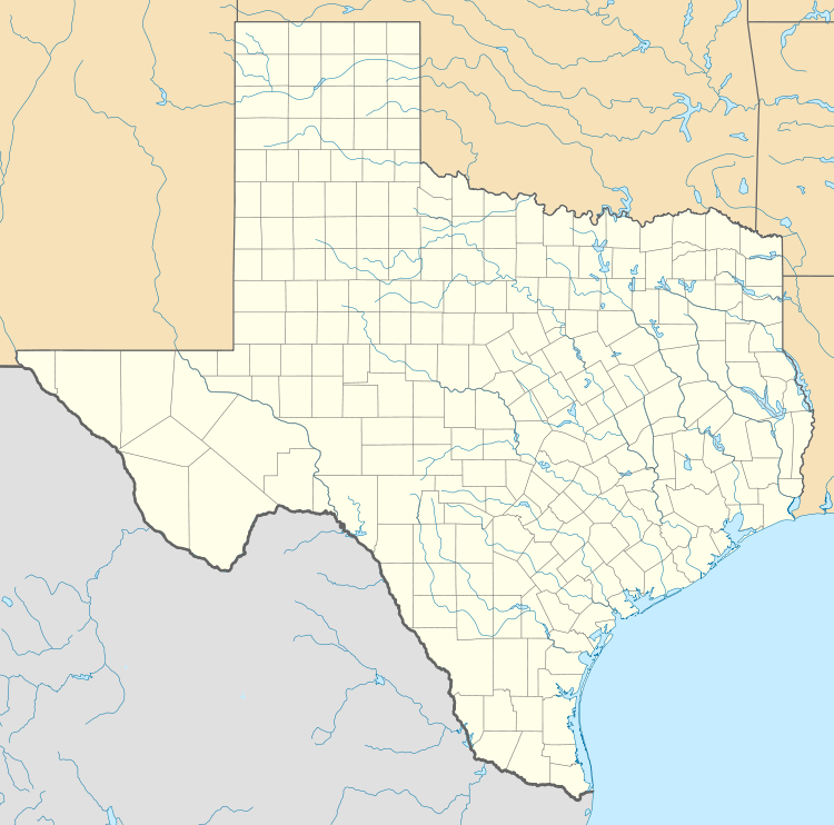
The Rosharon town site went unnamed during its early years. The area was settled by cotton and sugar plantations before the Civil War. Once the Houston Tap and Brazoria Railway (Columbia Tap) was completed in 1859, the Rosharon stop on the train line was given the name Masterson's Station, after a nearby plantation owned by Thomas G. Masterson (ca. 1813–1884). Rosharon was known locally by trainmen as "Buttermilk Station" because an early resident was known to bring a bucket of buttermilk and a dipper to the railroad station to give the engineer and crew a drink.
George Wetmore Colles, Jr. (1871–1951), an electrical and mechanical engineer educated at Yale University (BA 1892) and the Stevens Institute of Technology, bought property in the area around 1900 and called his estate the Rose of Sharon Garden Ranch after the many Cherokee Roses (Rosa laevigata) that grew there. Colles also designed the community water system.
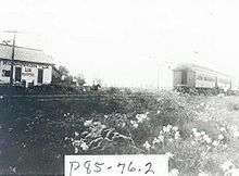
Antonio G. Arcaro served as Rosharon's postmaster from 1912 to 1920. The Rosharon post office was discontinued in 1920 and mail was then sent to Sandy Point. The post office reopened in 1936, only to be closed again in 1979. A new post office was dedicated under President Ronald Reagan and operates today.
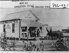
Tom Lochridge (1903–1985) platted the town site. Lochridge was responsible for having a cotton gin moved to Rosharon from Houston. Aside from providing employment for several persons, the gin's engine was used as Rosharon's first power plant. The community's first telephone exchange was operated out of Lochridge's home.
Rosharon's school was initially held in private home, and later in its own building. Eventually, the Rosharon school district was consolidated with the Angleton schools. Students began being bussed to Angleton in the late 1900s, a practice that continues to this day.
Church meetings were first held in a former school, then in a tavern that community members had bought and converted into a church. Eventually a brick church was constructed.
The South Texas Water Company located in Rosharon in 1935, and its fresh watercanals for irrigating rice brought some seventy-five to eighty rice farmers to the area.
By the late 1980s, Rosharon had an estimated population of 500. In 1990 the population was 435. Most residents commute to jobs in nearby towns.
Demographics
Neighborhoods include Songbird Ranch Airport (private), Lindell Estates, Lakes of Savannah, Southern Colony, Chenango Ranch, Coffee Lake, Seven Oaks Ranch, Sun Creek Estates, Sun Creek Ranch, Cold River Ranch and Sterling Lakes.
Economy
There are four Texas Department of Criminal Justice (TDCJ) prison units near Rosharon. Ramsey (formerly Ramsey I), Stringfellow (formerly Ramsey III), and Terrell (formerly Ramsey II) are all co-located.[2][3] In addition Darrington Unit is near Rosharon.[4] The Handbook of Texas stated that the prison authority employees and their family members "added considerably to [Rosharon's] economy."[5]
A Schlumberger product center is located in Rosharon.
Government and infrastructure

The Rosharon Volunteer Fire Department (RVFD) provides fire services for Rosharon. In the 1940s Rosharon community members, wanting to start a fire department, met with Brazoria County officials and purchased firefighting equipment. From the 1940s until 2004 the firefighting department received all of its support from fundraising events, private donations, and small contributions from the Brazoria County government. The volunteer group organized in 1956, and in 1986 the Rosharon Volunteer Fire Department, Inc. incorporated as a non-profit corporation. In 2002 taxpayers formed the Brazoria County Emergency Services District #3, which provides EMS services.[6]
The United States Postal Service operates the Rosharon Post Office at 1810 East Farm to Market Road 1462.[7]
Education
Students in Rosharon attend the Angleton Independent School District, as well as the Fort Bend Independent School District for residents in Southern Colony. In the 20th century the Rosharon school district was consolidated into the Angleton district, and busing into Angleton began in the late 20th century.[5] Some Rosharon residents attend Manvel schools in the Alvin ISD. Manvel High School, Manvel Junior High, and E.C Mason Elementary.
In the neighborhoods west of Chocolate Bayou, along the north side of F.M. 1462, students attend Alvin Primary, Alvin Elementary, Fairview Junior High and Alvin High School in Alvin.
Rosharon is within the attendance zone of the Alvin Community College. Rosharon was included through H.B. No. 2744,[8] filed on March 6, 2007.[9]
References
- ↑ "Geographic Identifiers: 2010 Demographic Profile Data (G001): Rosharon CDP, Texas". U.S. Census Bureau, American Factfinder. Retrieved April 17, 2014.
- ↑ "Terrell Unit." Texas Department of Criminal Justice. Retrieved on May 9, 2010.
- ↑ Staff and Wire Reports. "Parts of Houston join evacuation." Houston Chronicle. September 21, 2005. Retrieved on May 10, 2010.
- ↑ "DARRINGTON (DA)." Texas Department of Criminal Justice. Accessed September 12, 2008.
- 1 2 "Rosharon, Texas." Handbook of Texas. Retrieved on July 16, 2010.
- ↑ "About RVFD." Rosharon Volunteer Fire Department. Retrieved on September 17, 2010.
- ↑ "Post Office Location - Rosharon." United States Postal Service. Retrieved on March 30, 2009.
- ↑ "H.B. No. 2744." Texas Legislature. Retrieved on March 11, 2011. "(3) the territory located in Brazoria County, situated to the west of the Alvin Community College District boundary as it existed on January 1, 2003, extending west to the eastern border of Fort Bend County, and south to County Roads 49, 34, and 255, including the City of Rosharon and the Darrington and Ramsey Units of the Texas Department of Criminal Justice."
- ↑ "Bill: HB 2744." Texas Legislature. Retrieved on March 11, 2011.
External links
- Rosharon Volunteer Fire Department
- Handbook of Texas Online entry for Rosharon
- TDCJ Directory of Prison Units
Municipalities and communities of Brazoria County, Texas, United States | ||
|---|---|---|
| Cities |  | |
| Towns | ||
| Villages | ||
| CDPs | ||
| Other unincorporated communities | ||
| Footnotes | ‡This populated place also has portions in an adjacent county or counties | |