Snipe, Texas
| Snipe, Texas | |
|---|---|
| Unincorporated community | |
 Snipe Location within the state of Texas | |
| Coordinates: 29°07′25″N 95°28′56″W / 29.12361°N 95.48222°WCoordinates: 29°07′25″N 95°28′56″W / 29.12361°N 95.48222°W | |
| Country | United States |
| State | Texas |
| County | Brazoria |
| Elevation | 30 ft (9 m) |
| Time zone | Central (CST) (UTC-6) |
| • Summer (DST) | CDT (UTC-5) |
| ZIP codes | 77515 |
| Area code(s) | 979 |
| GNIS feature ID | 1380567[1] |
Snipe is an unincorporated community in central Brazoria County, Texas, United States. It was formerly a distinct community. The location of Snipe is 3 miles (4.8 km) southwest of Angleton on the Union Pacific Railroad and Oyster Creek. Raymond Weems, Snipe's first postmaster, named Snipe after a facetious reference made about the place by his father's hunting partner.[2]
A post office operated in Snipe from 1921 to 1949; the post office served the Retrieve Prison Farm (now the Wayne Scott Unit).[2]
References
- ↑ "Snipe, Texas". Geographic Names Information System. United States Geological Survey.
- 1 2 "Snipe, Texas." Handbook of Texas. Retrieved on July 16, 2010.
External links
- Snipe, Texas from the Handbook of Texas Online
Municipalities and communities of Brazoria County, Texas, United States | ||
|---|---|---|
| Cities | 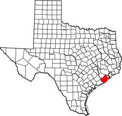 | |
| Towns | ||
| Villages | ||
| CDPs | ||
| Other unincorporated communities | ||
| Footnotes | ‡This populated place also has portions in an adjacent county or counties | |
This article is issued from Wikipedia - version of the 11/15/2015. The text is available under the Creative Commons Attribution/Share Alike but additional terms may apply for the media files.