Sandy Point, Texas
| Sandy Point, Texas | |
|---|---|
| City | |
 Sandy Point, Texas | |
| Coordinates: 29°23′08″N 95°28′52″W / 29.38556°N 95.48111°W | |
| Country | United States |
| State | Texas |
| County | Brazoria |
| Incorporated | 2002 |
| Elevation | 56 ft (17 m) |
| Time zone | Central (CST) (UTC-6) |
| • Summer (DST) | CDT (UTC-5) |
| ZIP code | 77583 |
| Area code(s) | 281, 832 |
| GNIS feature ID | 1346604[1] |
Sandy Point is a city[2] on Farm to Market Road 521 (FM 521) in north central Brazoria County, Texas, United States. The small community is located near a state prison. In the 19th century, the settlement served nearby sugar cane and cotton plantations. Sandy Point's post office, school and railroad have disappeared, but there were two churches in the community in December 2013.
History
Sandy Point incorporated in 2002 to avoid annexation from Missouri City. in 2005 Missouri City agreed to recognize the incorporation of Sandy Point.[3]
Government and infrastructure
The Rosharon Volunteer Fire Department provides fire services for Sandy Point.[4]
Sandy Point is located at the entrance to the Darrington Unit, a prison for men operated by the Texas Department of Criminal Justice.[5]
Demographics
| Historical population | |||
|---|---|---|---|
| Census | Pop. | %± | |
| Est. 2015 | 216 | [6] | |
Education
In the 2013–2014 school year, the Angleton Independent School District served the area of Sandy Point via Rosharon Zone Bus Route #223.[8]
 The Sandy Point Bible Church is on County Road 42 just west of FM 521.
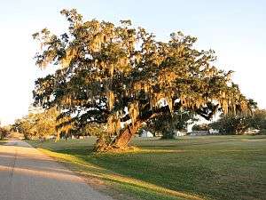 Live oak trees draped with Spanish moss are plentiful near Sandy Point. This one is on County Road 42.
References
- ↑ U.S. Geological Survey Geographic Names Information System: Sandy Point, Texas
- ↑ http://brazoria-county.com/engineer/maps/City%20Limits%20with%20ETJ.pdf
- ↑ "Missouri City agrees to recognize Sandy Point." The Facts (Southern Newspapers). April 7, 2005. Retrieved on October 17, 2009.
- ↑ Home page. Rosharon Volunteer Fire Department. Retrieved on September 17, 2010.
- ↑ "Sandy Point, Texas." Handbook of Texas. Retrieved on July 16, 2010.
- ↑ "Annual Estimates of the Resident Population for Incorporated Places: April 1, 2010 to July 1, 2015". Retrieved July 2, 2016.
- ↑ "Census of Population and Housing". Census.gov. Retrieved June 4, 2015.
- ↑ "General Documents: Route Stops and Times". Angleton Independent School District. Retrieved January 15, 2014.
External links
- Sandy Point, Texas from the Handbook of Texas Online
Municipalities and communities of Brazoria County, Texas, United States | ||
|---|---|---|
| Cities | 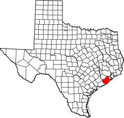 | |
| Towns | ||
| Villages | ||
| CDPs | ||
| Other unincorporated communities | ||
| Footnotes | ‡This populated place also has portions in an adjacent county or counties | |