Sabarmati Riverfront
|
| |
| Location | Ahmedabad, Gujarat, India |
|---|---|
| Coordinates | 23°02′03″N 72°34′20″E / 23.0341367°N 72.5723255°E |
| Status | Under construction |
| Groundbreaking | 2005 |
| Opening | Gradually since August 2012 |
| Use | Urban development |
| Website |
www |
| Companies | |
| Architect | Bimal Patel-led HCP Design, Planning and Management Pvt. Ltd[1] |
| Developer | Sabarmati River Front Development Corporation Limited |
| Technical details | |
| Cost | ₹ 1152 crore by June 2014[2] |
| Size | 202.79 hectares (501.1 acres) |
| Proposed | since 1960s |
Sabarmati Riverfront is a waterfront being developed along the banks of Sabarmati river in Ahmedabad, India. Proposed in 1960s, the construction began in 2005. Since 2012, the waterfront is gradually opened to public as and when facilities are constructed and various facilities are actively under construction. The major objectives of project are environment improvement, social infrastructure and sustainable development.
Geography
The Sabarmati river is a monsoon-fed river which has a total catchment area of 10,370 sqkm, out of the total basin area of 27,820 sqkm at Ahmedabad. Before the project, the width of the river varied from 300 m to 425 m. The Dharoi Dam constructed in 1976 upstream of Ahmedabad controls water and protects from flooding while Vasna Barrage constructed in 1976 downstream retains water in the river along the city banks and diverts it through Fatehwadi canal for irrigation. The Narmada Canal, which crosses Sabarmati a few kilometres upstream from the city, is part of a larger canal network of Sardar Sarovar Dam. The canal can feed excess water to the river and maintains the level of water in the river.
History
The modern city of Ahmedabad was founded in 1411 along the east bank of the Sabarmati river. The river had been the important source of water, economic and recreational activities in past. Over the years, the city expanded and the river was neglected. The river became polluted due to flow of untreated sewage through storm water lines and dumping of industrial waste. The slum encroachment along the banks were prone to floods and had no infrastructure. The river became inaccessible for general public and cause of health hazards. So it was proposed to develop the bank of river to turn it into major urban asset.
The first proposal for developing the riverfront was given in 1961 by prominent citizens of the city. French architect Bernard Kohn proposed an ecological valley in Sabarmati basin stretched from Dharoi Dam to Gulf of Cambay in 1960s.[2] In 1964, he proposed Integrated Planning & Development of Sabarmati Riverfront by reclaiming 30 hectares of land. The project was considered feasible in 1966 by the Government of Gujarat. Later he distanced himself from the project citing difference between his proposal and the project being implemented.[3] In 1976, the Riverfront Development Group proposed an incremental approach for the construction. In 1992, National River Conservation Plan proposed the construction of sewers and pumping stations to reduce water pollution.[4][5]
The Ahmedabad Municipal Corporation (AMC) set up the Sabarmati Riverfront Development Corporation Ltd (SRFDCL) in May 1997 funded by Government of India with a seed capital of ₹10 million (US$150,000) for riverfront development. Environmental Planning Collaborative (EPC) led by Bimal Patel prepared the feasibility report in 1998. Initially the proposal was to construct the riverfront to cover a stretch of 10.4 km stretch from Subhash bridge to Vasna barrage and to reclaim 162 hectares (400 acres) of the riverbed. In 2003, the project extended to cover a 11.25 km stretch and reclamation of 202.79 hectares (501.1 acres) and was put on fast track. The project estimated to cost ₹12 billion (US$180 million) which will be recovered by selling of part of reclaimed land for commercial and residential purpose.[2][6] Ahmedabad based HCP Design, Planning and Management Pvt. Ltd is roped in as the main architect of the project.[1] The project has encountered several delays due to concerns regarding water level, flooding, rehabilitation of displaced slum dwellers and the opposition from activists involved with slum rehabilitation.[7][8]
The construction began in 2005. Its heavy engineering and land reclamation is completed and the sewage system is also finished at the cost of ₹ 900 crore.[5] The 11.5 km long lower promenades on both banks are completed and some of its section were opened to public on 15 August 2012. It was inaugurated by then state Chief Minister Narendra Modi. Following this, the waterfront is gradually opened to public as and when facilities are finished. Various facilities are actively under construction since then.[5][9] Total ₹ 1152 crore is spent on the project by 2014.[2]
Riverfront
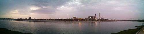
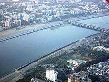
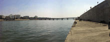
The average width of the river channel was 382 metres (1,253 ft) and the narrowest cross-section 330 metres (1,080 ft). It is uniformly narrowed to 263 metres (863 ft) without affecting its flood carrying capacity and the riverbed land is reclaimed on the both east and west banks to construct 11.25 km long riverfront. It can hold 470,000 cu ft/s (13,000 m3/s) without spillage. The total of 202.79 hectares of land is reclaimed. The reclaimed land is used for public as well as private development. More than 85% of the reclaimed land will be used for public infrastructure, recreational parks, sports facilities and gardens while nearly 14% will be used for commercial and residential purpose.[2][5]
It improves environment by reducing erosion of the banks and flooding of low-lying areas of the city by the walls constructed on the both banks. The new integrated sewage and storm-water system intercepts 38 former sewage and industrial effluent discharge points and route it to sewage treatment plants south of Vasna Barrage.[5] Thus it reduced the water pollution in the river. The water level in the river is retained through Vasna Barrage and the losing water is replenished by the Narmada Canal. It enabled the groundwater recharge and the recreational facilities like boating in the river.[10] There are also plans to replenish river by treated sewage water.[11]
Streets
The roads along the both banks are constructed for the easy movement of traffic along north-south direction. They are constructed with footpaths, parking bays, carriage ways and cycle tracks. The roads leading to river are strengthened for better movement and access. The West River Drive decongestants the Ashram Road and has 25m RoW. The East River Drive provides better north-south access to east part of the city and direct road to airport. It has 30m RoW.
Recreation and amenities
- Amenities

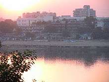
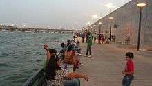
The two-level promenade is planned and the lower promenade is already constructed. These promenades provide continuous 11.2 km long walkway along the river on the east side and 11.3 km on west side. The width of the promenade varies from 6 to 18m. The 31 Ghats are constructed at regular interval along the lower promenade for access to the water. The boating stations are constructed for recreational purpose and for water-based public transport in the future. Three such stations are already open.
The 5.07 ha Events Ground is an event ground with infrastructure facilities. It serves as open venue for variety of purpose and revenue source for the project. The lawn is 40,000 square metres in size and can host over 50,000 people.[12] The 0.9 ha laundry campus with seven blocks opened in February 2014. It has washing areas on the ground level and drying facilities on the terraces. Fourteen public washrooms are under construction.[5]
The Sabarmati Ashram will be also connected to lower promenade and existing steps will be developed as an amphitheater. The 3.3 ha Heritage Plaza along the city walls between Ellis Bridge and Nehru Bridge will be designed as open space showcasing heritage, history and culture of the city. Some sports complexes are also proposed.
- Parks and gardens
Nearly 26% of the reclaimed land will be used for the parks and gardens to enhance environment and for public recreation. Some parks are already constructed and expanded while others are under construction and proposed.[13] The 6 ha park near Subhash Bridge and 1.8 ha park near Usmanpura were opened in October 2013. The 0.9 ha amusement park and 5 ha Flower Garden are under construction.
The 10.4 ha urban forest is proposed in Paldi which will be divided in two parts by Ambedkar Bridge. The north part will serve as garden while the south part will biodiversity park. It will have 15000 trees and will cost ₹ 167 crore.[14] The 1.4 ha park at Khanpur is proposed as a garden as well as location for concerts and outdoor performances.
- Markets
Several markets, vending areas, business and event grounds are planned. Ravivari or Gujari Bazar, the informal Sunday Market held under Ellis Bridge is moved to the new location near Gaekwad Haveli. The open air market has function arrangement of zones and 1641 platforms for vendors. It was opened to the public in February 2014.[5][15] The 5.7 ha Exhibition Centre, a trade-fair facility, is proposed on the eastern bank of the river. The 0.5 ha plaza at Vallabhsadan is also proposed as a market along upper promenade.
- Sports complexes
Three sports complexes are proposed; at Paldi (7.1 ha) for city-level sports, at Pirana (4.2 ha) for informal sports and at Shahpur (2.3) ha.
Residential and commercial development
It is planned to use nearly 14% of the reclaimed land for residential and commercial purposes. Total 52 buildings will be constructed including eight museums. For maximum usage of land, the floor space index (FSI) has been raised up to 5. The funds raised by selling the land will recover the cost of the construction and sustain the management of the riverfront. Total 41 plots will be sold in 2016. All construction will have to follow certain design guidelines.[2][16]
The SRFDCL office complex is being constructed at the cost of ₹ 48.83 crore.[17]
The slums along the riverbanks were relocated and rehabilitated on reserved land of reclamation and at other places. Nearly 4000 houses were constructed for the purpose of relocation of 10000 slum dwellers.
Culture
The riverfront is featured in several Gujarati as well as Bollywood films. It hosts several annual events like Sabarmati Marathon, Sabarmati Cyclothon, flower shows, International Kite Festival[18] and airshows.[19] Its continuous promenade attracts runners and fitness enthusiasts.[20] It also hosts trade shows, exhibitions and private wedding events.[21]
Criticism and controversy
The peak discharge in the Sabarmati in August 2006 was between 260,000 and 310,000 cu ft/s (8,800 m3/s), which caused floods that washed away hundreds of hutments. However, Gujarat state irrigation department measured a peak flow of 550,000 cu ft/s (16,000 m3/s) in 1973, before construction of Dharoi dam. So the project is criticized for lower capacity of 470,000 cu ft/s (13,000 m3/s). There are also concerns regarding perennial status of the river as it depends on the Narmada canal for water.
The project was delayed several times due to issues regarding relocation and rehabilitation of more than 10000 slum dwellers along the river banks. After petitions by activists, the Gujarat High Court intervened and ordered to stop demolition of slums until proper planning is implemented. The relocation and rehabilitation is completed later and faced criticism of activists for delays.[2][5][22][23][24]
Recognition and impact
| Wikimedia Commons has media related to Sabarmati Riverfront. |
- 1999: Prime Minister's Award for excellence in urban planning and design[25]
- 2006: Prime Ministers Award for excellence in “Urban Design & Concept” Award - Excellence in “Urban Design and Concept”[26]
- 2006: National Safety Council of India - Safety Award (Prashansa Patra)[26]
- 2011: Housing and Urban Development Corporation Award (HUDCO) - Innovative Infrastructure Development[26]
- 2012: Housing and Urban Development Corporation Award (HUDCO) - Best Practices to Improve the Living Environment[26][27]
- 2014: Construction Industry Development Council (CIDC) Vishwakarma Award - Best Construction Project[26]
Several other cities planned to follow the model for riverfront development including Vadodara, Surat, Pune, Varanasi, Chennai, Noida.[5][28][29]
References
- 1 2 "SRFDCL brings 'Riverfront House' to convince investors in Sabarmati". The Indian Express. 4 December 2014. Retrieved 24 April 2016.
- 1 2 3 4 5 6 7 John, Paul (8 June 2014). "'London Eye', museums and highrises being planned on Sabarmati riverfront". The Times of India. Retrieved 24 April 2016.
- ↑ Jha, Paras (6 January 2013). "I envisaged an Eco Valley not a Riverfront: Prof Bernard Kohn". Daily News & Analysis. Retrieved 21 February 2015.
- ↑ "Previous Proposals". Sabarmati Riverfront. 24 April 2016. Archived from the original on 24 April 2016. Retrieved 24 April 2016.
- 1 2 3 4 5 6 7 8 9 "The transformation of Sabarmati from a parched riverbed with puddles of industrial effluents to a bustling, swanky riverfront". timesofindia-economictimes. 24 January 2015. Retrieved 24 April 2016.
- ↑ Jawaharlal Nehru indiragandhi udyan National Urban Renewal Mission (2006). "Profile of the City Ahmedabad" (PDF). Ahmedabad Municipal Corporation Ahmedabad, Urban Development Authority and CEPT University, Ahmedabad. Ahmedabad Municipal Corporation. Retrieved 22 July 2008.
- ↑ Mahadevia, Darshini (2008). Inside the transforming urban Asia : processes, policies and public actions (1. publ. ed.). New Delhi: Concept. p. 650. ISBN 978-81-8069-574-2.
- ↑ Mathur, Navdeep (December 2012). "On the Sabarmati Riverfront" (PDF). Economic and Political Weekly. XLVII (47-48).
- ↑ "Overall Schedule". Sabarmati Riverfront. 23 March 2016. Archived from the original on 23 March 2016. Retrieved 24 April 2016.
- ↑ "Project Objectives". Sabarmati Riverfront. 16 March 2016. Archived from the original on 16 March 2016. Retrieved 24 April 2016.
- ↑ Firstpost (22 July 2013). "Ahmedabad: Treated sewage water to keep Sabarmati river flowing". Firstpost. Retrieved 24 April 2016.
- ↑ DeshGujarat (12 June 2015). "Ahmedabad's biggest lawn is ready at Sabarmati River Front (Photos)". DeshGujarat. Retrieved 24 April 2016.
- ↑ Devarhubli, Chaitra (8 October 2012). "Ahmedabad's Victoria Garden to be linked to Sabarmati riverfront". dna. Retrieved 24 April 2016.
- ↑ "Biodiversity park to come up at Riverfront". The Times of India. 27 March 2016. Retrieved 24 April 2016.
- ↑ "Come and see inclusive growth at Sabarmati Riverfront: Narendra Modi". timesofindia-economictimes. 3 February 2014. Retrieved 24 April 2016.
- ↑ DeshGujarat (20 January 2016). "SRFDCL to start selling development rights of River Front plots". DeshGujarat. Retrieved 24 April 2016.
- ↑ DeshGujarat (13 June 2015). "CM lays foundation stone of Sabarmati Riverfront Development Corporation Bhavan". DeshGujarat. Retrieved 24 April 2016.
- ↑ "Travel to Gujarat for the International Kite Festival 2016". India Today. 11 January 2016. Retrieved 24 April 2016.
- ↑ DeshGujarat (15 March 2015). "Air Show at Sabarmati River Front this April". DeshGujarat. Retrieved 24 April 2016.
- ↑ "Will Sabarmati riverfront be the next It destination?". The Times of India. 16 March 2016. Retrieved 24 April 2016.
- ↑ Bengali, Shashank (3 August 2014). "India river development project is a double-edged sword". Los Angeles Times. Retrieved 24 April 2016.
- ↑ "The untold story behind the Sabarmati riverfront". TwoCircles.net. 29 April 2014. Retrieved 24 April 2016.
- ↑ "Sabarmati riverfront: Dutch sociologist finds flaws in Gujarat model". The Indian Express. 10 February 2016. Retrieved 24 April 2016.
- ↑ "Sabarmati river front body gets PM's award". The Hindu Business Line. New Delhi. 11 April 2003. Retrieved 12 March 2013.
- 1 2 3 4 5 "Recognition - SABARMATI". Sabarmati Riverfront. Retrieved 24 April 2016.
- ↑ "AMC bags two awards for social housing, riverfront projects". The Times of India. TNN. 26 April 2011. Retrieved 12 March 2013.
- ↑ "PM Modi's ambitious Sabarmati project shows way to Akhilesh's Noida". The Times of India. 17 January 2016. Retrieved 24 April 2016.
- ↑ "Noida plans to revive Hindon like Sabarmati". Hindustan Times. 22 January 2016. Retrieved 24 April 2016.
External links
| Topics |  | |
|---|---|---|
| Regions of Gujarat |
| |
| Districts | ||
| Major cities | ||
| Ecoregions | ||
| Economy |
| |
| ||