Vadodara district
| Vadodara district | |
|---|---|
| district | |
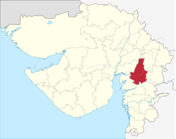 Location in Gujarat | |
| Coordinates: 22°11′N 73°07′E / 22.18°N 73.12°ECoordinates: 22°11′N 73°07′E / 22.18°N 73.12°E | |
| Country |
|
| State | Gujarat |
| Government | |
| • Collector | Avantika Singh Aulakh, IAS |
| Area | |
| • Total | 7,512 km2 (2,900 sq mi) |
| Population (2011) | |
| • Total | 4,165,626 [1] |
| • Density | 1,022/km2 (2,650/sq mi) |
| Languages | |
| • Official | Gujarati, Marathi,Hindi,English |
| Time zone | IST (UTC+5:30) |
| PIN | 390 0XX |
| ISO 3166 code | IN-GJ-VD |
| Vehicle registration | GJ |
| Lok Sabha constituency | 2[2] |
| Vidhan Sabha constituency | 12[3] |
| Climate | Semi-Arid (BSh) (Köppen) |
| Avg. annual temperature | 12-43 °C |
| Avg. summer temperature | 26-43 °C |
| Avg. winter temperature | 12-33 °C |
| Website |
gujaratindia |
Vadodara District is a district in the eastern part of the state of Gujarat in western India. The city of Vadodara (Baroda), in the western part of the district, is the administrative headquarters. Vadodara District covers an area of 7,794 km². It had a population of 3,641,802 of which 45.20% were urban as of 2001 census. As of 2011 it is the third most populous district of Gujarat (out of 26), after Ahmadabad and Surat.[4]
The district is bounded by Panchmahal and Dahod districts to the north, Anand and Kheda districts to the west, Bharuch and Narmada districts to the south, and the state of Madhya Pradesh to the east. The tallest point in the region is Pavagadh Hill. The Mahi River passes through the district.
The historical city of Baroda was the capital of Baroda Residency, and one of the princely states of India under Bombay Presidency.
Origin of name
Baroda is situated on the banks of the river Vishwamitri (whose name is derived from the saint Rishi Vishwamitra). The city was once called Chandravati, after its ruler Raja Chandan, then Viravati, the abode of the brave, and then Vadpatra because of the abundance of banyan trees on the banks of the Vishwamitri. From Vadpatra it derived its present name Baroda or Vadodara. Vadodara name came into existence as Vad (Banyan Tree) Dara(worn - Meaning covered with Vadvruksh) and hence it came as Vadodara. Anybody can see lot of Banyan Tree in and around Vadodara.
History
Modern Baroda is a memorial to its late ruler, Sayaji Rao Gaekwad III (1875–1939). It was the dream of this able administrator to make Baroda an educational, industrial and commercial centre.
Baroda has a rich historical background. The historian can trace Baroda’s history over 2000 years and more. However, the recent threads can be picked up when the Moghul rule over the city came to an end in 1732, when Pilaji brought the Maratha activities in Southern Gujarat to a head and captured it. Except for a short break, Baroda continued to be in the hands of the Gaekwads from 1734 to 1949.
The greatest period in the Maratha rule of Baroda started with the accession of Maharaja Sayajirao III in 1875. It was an era of great progress and constructive achievements in all fields.
Maharaja Sayajirao was one of the foremost administrators and reformers of his times. He initiated a series of bold socio-economic reforms. He attached great importance to economic development and started a number of model industries to encourage initiative, and then handed back the working industries to private enterprise. He started model textile and tile factories. It is as a result of his policy of industrial development that Baroda is today one of the most important centres for textile, chemical and oil industries today. He introduced a number of social reforms. In no department of administration has the far-sighted policy of this wise ruler been more conspicuous than in education, and in none have the results been more real and tangible. He boldly introduced compulsory primary education and a library movement (the first of its kind in India) to augment his adult education scheme.
It was he who visualised a general scheme of development in all branches of knowledge at different stages, with the Maharaja Sayajirao University of Baroda at the apex. Modern Baroda owes its beauty, its educational institutions and its masterpieces of architecture to the insight and vision of this great ruler.
Geography
The physiography of Vadodara features a number of rivers. The main city of Vadodara is located on the banks of river Vishwamitri. Besides, the topography of Vadodara also features Narmada river to its south and Mahi river to its north.
Climate
The Vadodara district has a dry climate and three distinct seasons, namely summer, winter and monsoon.
| Vadodara | ||||||||||||||||||||||||||||||||||||||||||||||||||||||||||||
|---|---|---|---|---|---|---|---|---|---|---|---|---|---|---|---|---|---|---|---|---|---|---|---|---|---|---|---|---|---|---|---|---|---|---|---|---|---|---|---|---|---|---|---|---|---|---|---|---|---|---|---|---|---|---|---|---|---|---|---|---|
| Climate chart (explanation) | ||||||||||||||||||||||||||||||||||||||||||||||||||||||||||||
| ||||||||||||||||||||||||||||||||||||||||||||||||||||||||||||
| ||||||||||||||||||||||||||||||||||||||||||||||||||||||||||||
Economy
Vadodara’s Industrial Growth Vadodara City runs through the golden corridor, from Ahmedabad to Vapi, and is one of India’s foremost industrial centres with dominant groups of chemicals and pharmaceuticals, cotton textiles and machine tools. The city witnessed a sudden spurt in industrial activity with the establishment of the Gujarat refinery in 1962. Various large-scale industries such as Gujarat State Fertilizers and Chemicals (GSFC), Indian Petrochemicals Corporation Limited (IPCL) and Gujarat Alkalis and Chemicals Limited (GACL) have come up in the vicinity of the Gujarat Refinery. The establishment of large industrial units in this region has automatically brought into existence a number of smaller enterprises. Several factors like raw material availability, product demand, and skillful mobilisation of human, financial and material resources by the government and private entrepreneurs had contributed to Vadodara’s efflorescence as one of India’s foremost industrial centres.
Divisions

Vadodara is divided into 2 Prants:[5]
Vadodara is divided into 8 talukas:[5]
Demographics
According to the 2011 census Vadodara district has a population of 4,157,568,..[4][4][6][7] The district has a population density of 551 inhabitants per square kilometre (1,430/sq mi) .[4] Its population growth rate over the decade 2001-2011 was 14.16%.[4] Vadodara has a sex ratio of 934 females for every 1000 males,.[4] It has a literacy rate of 81.21% in 2011, an impressive ten percentage points increase in 10 years.[4]
The city has witnessed high population growth (40%) from 1981 to 1991. However, it could not maintain the momentum of growth; the growth rate slowed down to 26% in the last decade. The population registered in 2001 was 13.06 lakhs as against 10.31 lakhs 1991. The compounded annual growth rate (CAGR) has been steadily declining from 4.64% in 1971-81 to 3.45% in 1981-1991, and further to 2.39% in 1991-2001. The population in 2005 has been estimated at around 14.69 lakhs. The population projection for 2011 is estimated around 17.54 lakhs and is based on the hypothesis that the city would grow at a constant rate due to the increasing urbanisation in the state. The trend also shows that the population would increase at a stabilised average annual growth rate of 2.99% from 2005 to 2011. The population density of the city has increased from 9527 per km2 in 1991 to 12064 per km2 in 2001. However, this density reduced to 9925 per km2 due to the addition of new areas (148 km2) in 2002. The jurisdiction of Vadodara city has further increased in February 2006 and covers urbanised areas of around 15–20 km2, on the northern side of the city.
a. Total population and growth rate of population over the last 5 years: Population of Vadodara 1,839,428 (Wikipedia) Year Population (lakhs) Average annual growth rate (%) 1981 7.34 4.64% 1991 10.31 3.45% 2001 13.06 2.39% 2005 (Estimated) 14.69 2.99% 2011 (Projected) 17.54 2.99%
Source: Census 2001
Culture
Notable personalities
- Premanand Bhatt (1649–1714) Author. Born in Vadodara.
- Yashodev Suri (1916–2006) Jain scholar. Born in Dabhoi.
- Param Pujya Brahmaleen Shree Dongreji Maharaj (1926-1990)[Mahapurush]
- Nayan Mongia Cricketer. Born in Vadodara
- Jacob Martin Cricketer. Born in Vadodara
- Pathan Brothers Irfan Pathan and Yusuf Pathan. Born in Vadodara
References
- ↑ Census, Indian. http://www.censusindia.gov.in/pca/SearchDetails.aspx?Id=549330. Missing or empty
|title=(help) - ↑ "List of Gujarat Lok Sabha Members". Lok Sabha. Retrieved 2007-06-30.
- ↑ "List of Vadodara District MLAs". Gujarat Vidhan Sabha. Retrieved 2007-06-30.
- 1 2 3 4 5 6 7 "District Census 2011". Census2011.co.in. 2011. Retrieved 2011-09-30.
- 1 2 "Collectorate of Vadodara". Vadodara District Collectorate. Retrieved 2007-06-30.
- ↑ US Directorate of Intelligence. "Country Comparison:Population". Retrieved 2011-10-01.
Lebanon 4,143,101 July 2011 est.
- ↑ "2010 Resident Population Data". U. S. Census Bureau. Retrieved 2011-09-30.
Oregon 3,831,074
External links
| Wikimedia Commons has media related to Vadodara district. |
- Vadodara Collectorate
- List of places in Vadodara
- Vadodara Municipal Corporation
- Vadodara lok sabha by election 2014
 |
Kheda district | Panchmahal district | Dohad district | |
| Anand district | |
Alirajpur district, Madhya Pradesh | ||
| ||||
| | ||||
| Bharuch district | Narmada district | Nandurbar district, Maharashtra |
22°17′35″N 73°11′37″E / 22.293067°N 73.193493°E
| Topics | 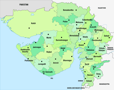 | |
|---|---|---|
| Regions of Gujarat |
| |
| Districts | ||
| Major cities | ||
| Ecoregions | ||
| Economy |
| |
| ||