Sagamiko, Kanagawa
| Sagamiko 相模湖町 | |
|---|---|
| Former municipality | |
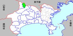 Location of Sagamiko in Kanagawa Prefecture | |
| Coordinates: 35°36′52″N 139°11′20″E / 35.6144°N 139.1890°ECoordinates: 35°36′52″N 139°11′20″E / 35.6144°N 139.1890°E | |
| Country | Japan |
| Region | Kantō |
| Prefecture | Kanagawa Prefecture |
| District | Tsukui |
| Merged |
March 11, 2007 (now part of Sagamihara) |
| Area | |
| • Total | 31.59 km2 (12.20 sq mi) |
| Population (March 1, 2006) | |
| • Total | 10,404 |
| • Density | 329.4/km2 (853/sq mi) |
| Symbols | |
| • Tree | Katsura |
| • Flower | Lilium auratum |
| • Bird | Mandarin duck |
| Time zone | Japan Standard Time (UTC+9) |
Sagamiko (相模湖町 Sagamiko-machi) was a town located in Tsukui District, Kanagawa Prefecture, Japan.
As of March 1, 2006, final population data before the amalgamation, the town had an estimated population of 10,404 and a density of 329.4 inhabitants per square kilometre (853/sq mi). The total area was 31.59 km2 (12.20 sq mi).
On March 20, 2006, Sagamiko, along with the town of Tsukui (also from Tsukui District), was merged into the expanded city of Sagamihara, and thus no longer exists as an independent municipality. It is now part of Midori-ku, Sagamihara.
| Wards of Yokohama | ||
|---|---|---|
| Wards of Kawasaki | ||
| Wards of Sagamihara | ||
| Core city | ||
| Special cities | ||
| Cities | ||
| Aikō District | ||
| Ashigarakami District | ||
| Ashigarashimo District | ||
| Kōza District | ||
| Miura District | ||
| Naka District | ||
This article is issued from Wikipedia - version of the 6/20/2016. The text is available under the Creative Commons Attribution/Share Alike but additional terms may apply for the media files.