Santa Barbara County, California
| Santa Barbara County, California | |||||||
|---|---|---|---|---|---|---|---|
| County | |||||||
| County of Santa Barbara | |||||||
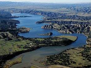
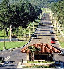
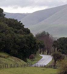
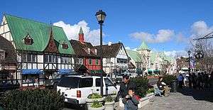
Images, from top down, left to right: The Santa Barbara County Courthouse; Lake Cachuma; Vandenberg Air Force Base's main gate; along Foxen Canyon Road, running between the Santa Maria and Santa Ynez Valleys; Danish-styled Solvang | |||||||
| |||||||
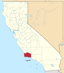 Location in the state of California | |||||||
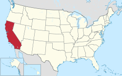 California's location in the United States | |||||||
| Country |
| ||||||
| State |
| ||||||
| Region | California Central Coast | ||||||
| Incorporated | February 18, 1850[1] | ||||||
| County seat | Santa Barbara | ||||||
| Largest city |
Santa Maria (population) Santa Barbara (area) | ||||||
| Area | |||||||
| • Total | 3,789 sq mi (9,810 km2) | ||||||
| • Land | 2,735 sq mi (7,080 km2) | ||||||
| • Water | 1,054 sq mi (2,730 km2) | ||||||
| Highest elevation[2] | 6,803 ft (2,074 m) | ||||||
| Population (April 1, 2010)[3] | |||||||
| • Total | 423,895 | ||||||
| • Estimate (2015)[3] | 444,769 | ||||||
| • Density | 110/sq mi (43/km2) | ||||||
| Time zone | Pacific Time Zone (UTC-8) | ||||||
| • Summer (DST) | Pacific Daylight Time (UTC-7) | ||||||
| Area code(s) | 805 | ||||||
| Website | www.countyofsb.org | ||||||

Santa Barbara County, California, officially the County of Santa Barbara, is a county located in the southern portion of the state of California, in the United States. As of the 2010 census, the population was 423,895.[3] The county seat is Santa Barbara,[4] and the largest city is Santa Maria.
Santa Barbara County comprises the Santa Maria-Santa Barbara, CA Metropolitan Statistical Area. Most of the county is part of the California Central Coast.[5] Mainstays of the county's economy include engineering, resource extraction (particularly petroleum extraction and diatomaceous earth mining), winemaking, agriculture, and education. The software development and tourism industries are important employers in the southern part of the county.
Southern Santa Barbara County is sometimes considered the northern cultural boundary of Southern California.[6]
History
The Santa Barbara County area, including the Northern Channel Islands, was first settled by Native Americans at least 13,000 years ago. Evidence for a Paleoindian presence has been found in the form of a fluted Clovis-like point found in the 1980s along the western Santa Barbara Coast, as well as the remains of Arlington Springs Man found on Santa Rosa Island in the 1960s. For thousands of years, the area was home to the Chumash tribe of Native Americans, complex hunter-gatherers who lived along the coast and in interior valleys leaving rock art in many locations including Painted Cave.
Europeans first contacted the Chumash in AD 1542, when three Spanish ships under the command of Juan Rodríguez Cabrillo explored the area. The Santa Barbara Channel received its name from Spanish explorer Sebastián Vizcaíno when he sailed along the California coast in 1602; his ships entered the channel on December 4, the day of the feast of Santa Barbara. Spanish ships associated with the Manila Galleon trade probably made emergency stops along the coast during the next 167 years, but no permanent settlements were established.
The first land expedition to explore California, led by Gaspar de Portolà explored the coastal area in 1769, on its way to Monterey Bay. The party traveled the same route on the return to San Diego in January 1770. That same year, a second expedition to Monterey again passed through the area.[7] The DeAnza expeditions of 1774-76 followed Portola's trail.
.jpg)
The Presidio of Santa Barbara was established in 1782 (4th of 5 in California), followed by Mission Santa Barbara in 1786 – both in what is now the city of Santa Barbara. The presidio and mission kept Vizcaino's denomination, as did the later city and county – a common practice which has preserved the names of many of the 21 California Missions.
European contacts had devastating effects on the Chumash people, including a series of disease epidemics that drastically reduced Chumash population. The Chumash survived, however, and thousands of Chumash descendants still live in the Santa Barbara area or surrounding counties. A tribal homeland was established in 1901, the Santa Ynez Reservation.[8]
Following the Mexican secularization of the missions in the 1830s, the mission pasture lands were mostly broken up into large ranchos and granted mainly to prominent local citizens who already lived in the area. 604 of these land grants were later confirmed by the state of California, with 36 in Santa Barbara County.[9]
Santa Barbara County was one of the 26 original counties of California, formed in 1850 at the time of statehood. The county's territory was later divided to create Ventura County in 1873.[10]
Geography
According to the U.S. Census Bureau, the county has a total area of 3,789 square miles (9,810 km2), of which 2,735 square miles (7,080 km2) is land and 1,054 square miles (2,730 km2) (27.8%) is water.[12] Four of the Channel Islands – San Miguel Island, Santa Cruz Island, Santa Rosa Island and Santa Barbara Island – are in Santa Barbara County. They form the largest part of the Channel Islands National Park (which also includes Anacapa Island in Ventura County).
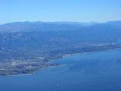
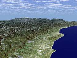
Santa Barbara County has a mountainous interior abutting several coastal plains on the west and south coasts of the county. The largest concentration of population is on the southern coastal plain, referred to as the "south coast" – meaning the part of the county south of the Santa Ynez Mountains. This region includes the cities of Santa Barbara, Goleta, and Carpinteria, as well as the unincorporated areas of Hope Ranch, Summerland, Mission Canyon, Montecito and Isla Vista, along with stretches of unincorporated area such as Noleta/Nanta Barbara("No" to "Goleta" or "Santa Barbara"). North of the Santa Ynez range in the Santa Ynez Valley are the towns of Santa Ynez, Solvang, Buellton, Lompoc; the unincorporated towns of Los Olivos and Ballard; the unincorporated areas of Mission Hills and Vandenberg Village; and Vandenberg Air Force Base, where the Santa Ynez River flows out to the sea. North of the Santa Ynez Valley are the cities of Santa Maria and Guadalupe, and the unincorporated towns of Orcutt, Los Alamos, Casmalia, Garey, and Sisquoc. In the extreme northeastern portion of the county are the small cities of New Cuyama, Cuyama, and Ventucopa. As of January 1, 2006, Santa Maria has become the largest city in Santa Barbara County.[13]
The principal mountain ranges of the county are the Santa Ynez Mountains in the south, and the San Rafael Mountains and Sierra Madre Mountains in the interior and northeast. Most of the mountainous area is within the Los Padres National Forest, and includes two wilderness areas: the San Rafael Wilderness and the Dick Smith Wilderness. The highest elevation in the county is 6820 feet (2079 m) at Big Pine Mountain in the San Rafaels.
North of the mountains is the arid and sparsely populated Cuyama Valley, portions of which are in San Luis Obispo and Ventura Counties. Oil production, ranching, and agriculture dominate the land use in the privately owned parts of the Cuyama Valley; the Los Padres National Forest is adjacent to the south, and regions to the north and northeast are owned by the Bureau of Land Management and the Nature Conservancy.
Rivers in Santa Barbara County include:
- Goleta Slough
- Montecito Creek
- Cold Springs Creek
- East Fork Cold Springs Creek
- West Fork Cold Springs Creek
- Cold Springs Creek
- Oak Creek
- San Ysidro Creek
- Romero Creek
- Picay Creek
- Toro Canyon Creek
- Garapata Creek
- Buell Reservoir Creek
- Arroyo Paredon
- Santa Monica Creek
- Franklin Creek
- Carpinteria Creek
- Gobernador Creek
- Eldorado Creek
- Steer Creek
- Carpinteria Reservoir Creek
- Gobernador Creek
- Rincon Creek
- Casitas Creek
- Sulphur Creek
- Catharina Creek
The Goleta Slough is in Goleta by Goleta Beach, and the Montecito Creek is in the unincorporated community of Montecito.
Air quality in the county, unlike much of southern California, is generally good because of the prevailing winds off of the Pacific Ocean. The county is in attainment of federal standards for ozone and particulate matter, but exceeds state standards for these pollutants. Sometimes in late summer and early autumn there are days with higher ozone levels; usually this occurs when there is a low inversion layer under a stagnant air mass, which traps pollutants underneath. In these cases a traveler into the mountains encounters a curious paradox: the temperature rises as altitude increases. On these days the visibility from the higher summits may be more than a hundred miles, while the population on the coastal plain experiences haze and smog.
Climate
Santa Barbara County receives a mild climate. Along the coast, the temperature rarely goes above or at the 100s in the summer and below or even at freezing in the winter. In the interior, temperatures can soar, though, and above 2,000 feet, temperatures plummet during the winter months, often going to, or below, freezing. The climate is called the warm-summer Mediterranean climate.
Biodiversity
Oak, pine, palm, lemon, and more trees also grow in the region. Poison oak and castor bean are two types of poisonous plant that like the region. While uncommon, poison hemlock may appear. Invasive weeds and grasses sometimes pop up in the region.
Wasps, yellowjackets, bees, monarch butterflies, and other insects reside in Santa Barbara County. Lizards, rattlesnakes, orcas, sea lions, owls, crows, and other animals have made their homes in the county. Squirrels, rats, opossums, the raccoon, and the skunk are common. Predators include red foxes, coyotes, bobcats, cougars, and American black bears. Most large predators appear only in the wild, but some appear in urban areas.
The four Channel Islands in Santa Barbara County are Santa Barbara Island, San Miguel Island, Santa Rosa Island, and the large Santa Cruz Island. All of them contain native and endemic wildlife, like the island oak and Torrey Pine. All four have the deer mouse living on them, the three latter, the island fox, and the two latter, the island spotted skunk. There used to be skunks on San Miguel Island, but due predation from marine life, birds, and foxes, the San Miguel Island skunk has gone extinct.
Geology and soils
Marine terraces and bedrock formations and faults make up much of Santa Barbara County. The coast of the county is a coastal plain, backed by mountains and then semi-desert, valleys, and mountains in the interior.
National protected areas

- Channel Islands National Park (part)
- Guadalupe-Nipomo Dunes National Wildlife Refuge (part)
- Los Padres National Forest (part)
- Burton Mesa Ecological Reserve
Demographics
2011
| Population, race, and income | |||||
|---|---|---|---|---|---|
| Total population[14] | 419,793 | ||||
| White[14] | 320,583 | 76.4% | |||
| Black or African American[14] | 7,752 | 1.8% | |||
| American Indian or Alaska Native[14] | 4,191 | 1.0% | |||
| Asian[14] | 20,905 | 5.0% | |||
| Native Hawaiian or other Pacific Islander[14] | 880 | 0.2% | |||
| Some other race[14] | 50,121 | 11.9% | |||
| Two or more races[14] | 15,361 | 3.7% | |||
| Hispanic or Latino (of any race)[15] | 175,692 | 41.9% | |||
| Per capita income[16] | $30,330 | ||||
| Median household income[17] | $61,896 | ||||
| Median family income[18] | $71,695 | ||||
Places by population, race, and income
| Places by population and race | ||||||||
|---|---|---|---|---|---|---|---|---|
| Place | Type[19] | Population[14] | White[14] | Other[14] [note 1] |
Asian[14] | Black or African American[14] |
Native American[14] [note 2] |
Hispanic or Latino (of any race)[15] |
| Ballard | CDP | 429 | 94.6% | 4.4% | 0.0% | 0.0% | 0.9% | 5.4% |
| Buellton | City | 4,712 | 69.9% | 23.0% | 4.2% | 0.4% | 2.5% | 38.9% |
| Carpinteria | City | 13,106 | 73.0% | 21.9% | 3.4% | 0.4% | 1.4% | 42.6% |
| Casmalia | CDP | 224 | 100.0% | 0.0% | 0.0% | 0.0% | 0.0% | 95.1% |
| Cuyama | CDP | 88 | 100.0% | 0.0% | 0.0% | 0.0% | 0.0% | 50.0% |
| Garey | CDP | 160 | 40.6% | 59.4% | 0.0% | 0.0% | 0.0% | 65.6% |
| Goleta | City | 29,634 | 74.5% | 14.5% | 9.6% | 1.1% | 0.4% | 30.5% |
| Guadalupe | City | 6,901 | 82.2% | 13.4% | 1.2% | 1.2% | 2.0% | 85.3% |
| Isla Vista | CDP | 23,640 | 66.1% | 15.7% | 14.6% | 2.0% | 1.5% | 21.9% |
| Lompoc | City | 42,178 | 64.8% | 24.3% | 2.9% | 5.8% | 2.2% | 51.7% |
| Los Alamos | CDP | 1,430 | 63.2% | 30.9% | 2.4% | 0.0% | 3.4% | 49.9% |
| Los Olivos | CDP | 928 | 95.7% | 3.2% | 0.4% | 0.0% | 0.6% | 6.6% |
| Mission Canyon | CDP | 1,885 | 91.5% | 8.5% | 0.0% | 0.0% | 0.0% | 10.9% |
| Mission Hills | CDP | 3,512 | 86.1% | 9.9% | 1.7% | 1.5% | 0.9% | 37.2% |
| Montecito | CDP | 9,079 | 92.0% | 4.6% | 1.9% | 0.7% | 0.8% | 6.4% |
| New Cuyama | CDP | 473 | 82.9% | 11.8% | 0.0% | 1.1% | 4.2% | 56.9% |
| Orcutt | CDP | 28,591 | 85.8% | 8.0% | 3.6% | 1.3% | 1.3% | 19.8% |
| Santa Barbara | City | 88,192 | 74.8% | 18.6% | 3.8% | 1.9% | 0.9% | 38.4% |
| Santa Maria | City | 96,803 | 78.6% | 13.8% | 5.4% | 1.3% | 0.9% | 70.1% |
| Santa Ynez | CDP | 5,018 | 81.0% | 10.9% | 0.3% | 0.5% | 7.3% | 18.8% |
| Sisquoc | CDP | 211 | 56.4% | 26.5% | 0.0% | 0.0% | 17.1% | 44.5% |
| Solvang | City | 5,237 | 91.0% | 5.3% | 1.1% | 0.1% | 2.6% | 20.1% |
| Summerland | CDP | 1,381 | 80.4% | 9.0% | 10.6% | 0.0% | 0.0% | 3.1% |
| Toro Canyon | CDP | 1,205 | 92.9% | 2.1% | 5.0% | 0.0% | 0.0% | 2.5% |
| Vandenberg AFB | CDP | 3,886 | 66.3% | 18.0% | 4.9% | 8.3% | 2.4% | 19.0% |
| Vandenberg Village | CDP | 6,797 | 85.5% | 8.6% | 2.8% | 1.7% | 1.4% | 15.0% |
| Places by population and income | |||||
|---|---|---|---|---|---|
| Place | Type[19] | Population[20] | Per capita income[16] | Median household income[17] | Median family income[18] |
| Ballard | CDP | 429 | $52,048 | $123,750 | $137,000 |
| Buellton | City | 4,712 | $29,017 | $66,964 | $96,719 |
| Carpinteria | City | 13,106 | $34,182 | $68,498 | $75,479 |
| Casmalia | CDP | 224 | $11,113 | $38,750 | $38,320 |
| Cuyama | CDP | 88 | $11,897 | $46,875 | $46,875 |
| Garey | CDP | 160 | $19,144 | $85,694 | $44,375 |
| Goleta | City | 29,634 | $34,263 | $72,870 | $91,370 |
| Guadalupe | City | 6,901 | $13,647 | $44,575 | $44,965 |
| Isla Vista | CDP | 23,640 | $10,324 | $22,834 | $44,613 |
| Lompoc | City | 42,178 | $19,851 | $47,592 | $52,811 |
| Los Alamos | CDP | 1,430 | $31,110 | $72,717 | $68,750 |
| Los Olivos | CDP | 928 | $53,469 | $78,750 | $96,250 |
| Mission Canyon | CDP | 1,885 | $58,109 | $77,212 | $121,250 |
| Mission Hills | CDP | 3,512 | $33,425 | $67,875 | $71,250 |
| Montecito | CDP | 9,079 | $74,853 | $112,656 | $143,194 |
| New Cuyama | CDP | 473 | $17,082 | $42,574 | $43,036 |
| Orcutt | CDP | 28,591 | $30,843 | $67,453 | $78,474 |
| Santa Barbara | City | 88,192 | $37,087 | $63,401 | $76,171 |
| Santa Maria | City | 102,087 | $18,915 | $51,664 | $53,166 |
| Santa Ynez | CDP | 5,018 | $43,711 | $102,618 | $102,571 |
| Sisquoc | CDP | 211 | $19,860 | $50,833 | $52,917 |
| Solvang | City | 5,237 | $39,139 | $61,133 | $74,782 |
| Summerland | CDP | 1,381 | $46,569 | $78,750 | $102,188 |
| Toro Canyon | CDP | 1,205 | $85,602 | $108,438 | $121,500 |
| Vandenberg AFB | CDP | 3,886 | $20,595 | $56,139 | $56,778 |
| Vandenberg Village | CDP | 6,797 | $35,189 | $78,480 | $92,816 |
2010
The 2010 United States Census reported that Santa Barbara County had a population of 423,895. The ethnic makeup of Santa Barbara County was 295,124 (69.6%) White, 8,513 (2.0%) African American, 5,485 (1.3%) Native American, 20,665 (4.9%) Asian (1.6% Filipino, 1.0% Chinese, 0.5% Japanese, 0.5% Korean, 0.3% Vietnamese, 0.4% Indian), 806 (0.2%) Pacific Islander, 73,860 (17.4%) from other races, and 19,442 (4.6%) from two or more races. Hispanic or Latino of any race were 181,687 persons (42.9%); 38.5% of Santa Barbara County is Mexican, 0.4% Salvadoran, 0.4% Guatemalan, and 0.3% Puerto Rican.[21]
| Population reported at 2010 United States Census | |||||||||
|---|---|---|---|---|---|---|---|---|---|
Population | American | American | | Islander | races | more races | or Latino (of any race) | ||
| Santa Barbara County | 423,895 | 295,124 | 8,513 | 5,485 | 20,665 | 806 | 73,860 | 19,442 | 181,687 |
cities | Population | American | American | | Islander | races | more races | or Latino (of any race) | |
| Buellton | 4,828 | 3,912 | 37 | 76 | 137 | 5 | 424 | 237 | 1,451 |
| Carpinteria | 13,040 | 9,348 | 109 | 144 | 296 | 15 | 2,599 | 529 | 6,351 |
| Goleta | 29,888 | 20,833 | 469 | 283 | 2,728 | 26 | 4,182 | 1,367 | 9,824 |
| Guadalupe | 7,080 | 3,395 | 74 | 103 | 279 | 5 | 2,783 | 441 | 6,103 |
| Lompoc | 42,434 | 25,950 | 2,432 | 750 | 1,615 | 186 | 9,020 | 2,481 | 21,557 |
| Santa Barbara | 88,410 | 66,411 | 1,420 | 892 | 3,062 | 116 | 13,032 | 3,477 | 33,591 |
| Santa Maria | 99,553 | 55,983 | 1,656 | 1,818 | 5,054 | 161 | 29,841 | 5,040 | 70,114 |
| Solvang | 5,245 | 4,326 | 38 | 59 | 72 | 1 | 611 | 138 | 1,530 |
places | Population | American | American | | Islander | races | more races | or Latino (of any race) | |
| Ballard | 467 | 432 | 3 | 1 | 2 | 0 | 12 | 17 | 46 |
| Casmalia | 138 | 91 | 3 | 0 | 1 | 0 | 30 | 13 | 58 |
| Cuyama | 57 | 40 | 0 | 2 | 0 | 0 | 14 | 1 | 40 |
| Garey | 68 | 53 | 0 | 1 | 0 | 0 | 5 | 9 | 21 |
| Isla Vista | 23,096 | 14,875 | 594 | 104 | 3,387 | 45 | 2,686 | 1,405 | 5,265 |
| Los Alamos | 1,890 | 1,667 | 5 | 10 | 32 | 0 | 134 | 42 | 773 |
| Los Olivos | 1,132 | 1,049 | 1 | 4 | 12 | 5 | 40 | 21 | 125 |
| Mission Canyon | 2,381 | 2,193 | 14 | 17 | 40 | 11 | 35 | 71 | 198 |
| Mission Hills | 3,576 | 2,689 | 91 | 74 | 125 | 9 | 386 | 202 | 1,137 |
| Montecito | 8,965 | 8,267 | 55 | 38 | 218 | 6 | 156 | 225 | 605 |
| New Cuyama | 517 | 418 | 3 | 14 | 3 | 0 | 53 | 26 | 234 |
| Orcutt | 35,262 | 28,677 | 394 | 347 | 1,129 | 59 | 2,006 | 1,293 | 6,530 |
| Santa Ynez | 4,418 | 3,797 | 12 | 234 | 51 | 4 | 147 | 173 | 639 |
| Sisquoc | 183 | 146 | 0 | 5 | 3 | 0 | 9 | 20 | 58 |
| Summerland | 1,448 | 1,295 | 3 | 7 | 41 | 6 | 51 | 45 | 192 |
| Toro Canyon | 1,508 | 1,388 | 7 | 7 | 14 | 1 | 73 | 18 | 293 |
| Vandenberg AFB | 3,338 | 2,317 | 307 | 26 | 207 | 24 | 140 | 317 | 616 |
| Vandenberg Village | 6,497 | 5,029 | 271 | 60 | 323 | 58 | 432 | 324 | 1,216 |
communities | Population | American | American | | Islander | races | more races | or Latino (of any race) | |
| All others not CDPs (combined) | 44,833 | 35,543 | 515 | 409 | 1,834 | 63 | 4,959 | 1,510 | 12,780 |
2000
| Historical population | |||
|---|---|---|---|
| Census | Pop. | %± | |
| 1850 | 1,185 | — | |
| 1860 | 3,543 | 199.0% | |
| 1870 | 7,784 | 119.7% | |
| 1880 | 9,513 | 22.2% | |
| 1890 | 15,754 | 65.6% | |
| 1900 | 18,934 | 20.2% | |
| 1910 | 27,738 | 46.5% | |
| 1920 | 41,097 | 48.2% | |
| 1930 | 65,167 | 58.6% | |
| 1940 | 70,555 | 8.3% | |
| 1950 | 98,220 | 39.2% | |
| 1960 | 168,962 | 72.0% | |
| 1970 | 264,324 | 56.4% | |
| 1980 | 298,694 | 13.0% | |
| 1990 | 369,608 | 23.7% | |
| 2000 | 399,347 | 8.0% | |
| 2010 | 423,895 | 6.1% | |
| Est. 2015 | 444,769 | [22] | 4.9% |
| U.S. Decennial Census[23] 1790–1960[24] 1900–1990[25] 1990–2000[26] 2010–2015[3] | |||
As of the census[27] of 2000, there were 399,347 people, 136,622 households, and 89,487 families residing in the county. The population density was 146 people per square mile (56/km²). There were 142,901 housing units at an average density of 52 per square mile (20/km²). The ethnic makeup of the county was 72.7% White, 2.3% Black or African American, 1.2% Native American, 4.1% Asian, 0.2% Pacific Islander, 15.2% from other races, and 4.3% from two or more races. 34.2% of the population were Hispanic or Latino of any race. 9.1% were of German, 8.5% English and 6.5% Irish ancestry according to Census 2000. 26.6% of the population reported speaking Spanish at home.[28]
There were 136,622 households out of which 32.4% had children under the age of 18 living with them, 51.4% were married couples living together, 10.0% had a female householder with no husband present, and 34.5% were non-families. 24.3% of all households were made up of individuals and 9.4% had someone living alone who was 65 years of age or older. The average household size was 2.8 and the average family size was 3.33.
In the county the population was spread out with 24.9% under the age of 18, 13.3% from 18 to 24, 29.0% from 25 to 44, 20.1% from 45 to 64, and 12.7% who were 65 years of age or older. The median age was 33 years. For every 100 females there were 100.1 males. For every 100 females age 18 and over, there were 98.1 males.
The median income for a household in the county was $46,677, and the median income for a family was $54,042. Males had a median income of $37,997 versus $29,593 for females. The per capita income for the county was $23,059. About 8.5% of families and 14.3% of the population were below the poverty line, including 16.3% of those under age 18 and 6.2% of those age 65 or over.
The population of the area south of the Santa Ynez Mountain crest—the portion known as "South County"—was 201,161 according to the 2000 census; thus the population is almost exactly split between north and south. Recent years have shown slow or even negative growth for regions in the south county, while areas in the north county have continued to grow at a faster rate.
Government
The County is governed by a five-member Board of Supervisors. The Board's three-vote majority has shifted over the years between the north and south. The Board majority now includes three members from the southern portion of the County.
The Board of Supervisors appoints a County Executive Officer, who serves at the pleasure of the Board, to operate the County governmental organization. The County government includes 4296 employees and a budget of $757 million. The County provides various services ranging from health services to law enforcement.
Federal and state representation
All of Santa Barbara County is located within California's 24th congressional district, represented by Democrat Lois Capps.[29] Prior to the 2012 redistricting in California, the county was divided into two congressional districts, which reflected the north and south divide – the hallmark of the county's politics. Lois Capps represented the coastal areas, while Elton Gallegly, a Republican, represented the northern part of the county.
In the California State Senate, Santa Barbara is in the 19th Senate District, represented by Democrat Hannah-Beth Jackson.[30] In the California State Assembly, Santa Barbara is split between the 35th Assembly District, represented by Republican Jordan Cunningham, and the 37th Assembly District, represented by Democrat Monique Limón.[31]
Politics
| Year | GOP | DEM | Others |
|---|---|---|---|
| 2016 | 32.0% 53,740 | 59.5% 100,120 | 8.5% 14,315 |
| 2012 | 39.4% 64,606 | 57.4% 94,129 | 3.1% 5,150 |
| 2008 | 37.4% 65,585 | 60.2% 105,614 | 2.4% 4,208 |
| 2004 | 45.2% 76,806 | 53.2% 90,314 | 1.6% 2,741 |
| 2000 | 46.1% 71,493 | 47.4% 73,411 | 6.5% 10,070 |
| 1996 | 42.4% 63,915 | 46.9% 70,650 | 10.7% 16,180 |
| 1992 | 35.3% 57,375 | 42.5% 69,215 | 22.2% 36,166 |
| 1988 | 54.2% 77,524 | 44.5% 63,586 | 1.3% 1,830 |
| 1984 | 62.8% 89,314 | 36.0% 51,243 | 1.2% 1,763 |
| 1980 | 54.0% 69,629 | 31.5% 40,650 | 14.5% 18,716 |
| 1976 | 50.8% 60,922 | 45.9% 55,018 | 3.3% 3,904 |
| 1972 | 55.2% 67,075 | 41.6% 50,609 | 3.2% 3,857 |
| 1968 | 53.6% 50,068 | 40.2% 37,565 | 6.2% 5,787 |
| 1964 | 44.0% 38,020 | 55.9% 48,381 | 0.1% 85 |
| 1960 | 56.7% 38,805 | 43.0% 29,409 | 0.3% 188 |
| 1956 | 64.6% 31,294 | 34.9% 16,925 | 0.6% 265 |
| 1952 | 67.2% 32,160 | 32.4% 15,490 | 0.4% 179 |
| 1948 | 58.1% 19,998 | 38.0% 13,085 | 3.8% 1,317 |
| 1944 | 46.3% 13,647 | 53.4% 15,721 | 0.3% 89 |
| 1940 | 44.5% 14,107 | 54.4% 17,237 | 1.1% 334 |
| 1936 | 37.4% 9,728 | 61.1% 15,923 | 1.5% 394 |
| 1932 | 38.1% 8,864 | 57.4% 13,373 | 4.5% 1,054 |
| 1928 | 69.4% 11,666 | 29.5% 4,954 | 1.1% 179 |
| 1924 | 64.7% 8,615 | 9.3% 1,242 | 26.0% 3,461 |
| 1920 | 67.5% 6,970 | 25.0% 2,586 | 7.5% 773 |
In terms of aggregate, the county has leaned to the left in recent years. Overall, Santa Barbara is a Democratic-leaning county in Presidential and congressional elections. The last Republican to win a majority in the county was George H. W. Bush in 1988. However, there is a dramatic difference in gradient between the "conservative" northern areas and the "liberal" southern areas of the county.
Santa Barbara County has long been divided between competing political interests. North of the Santa Ynez Mountains, agricultural activities and oil development have long provided jobs. The northern portion also contains a large military base, Vandenberg Air Force Base, and thus military interests are prominent. These influences have created a Republican-leaning northern half.
On the other hand, the southern portion of Santa Barbara county has had an economy based on tourism, with a significant percentage of people with white-collar jobs, formerly in aerospace but more recently in software and other high-tech pursuits. Additionally, the University of California, Santa Barbara contributes to a liberal populace. The southern portion of the county has a strong history of left-wing activism, with anti-war protests common in Santa Barbara. It is generally believed that the inspiration for Earth Day was the 1969 Santa Barbara oil spill; however, Gaylord Nelson, the senator who proposed the idea, has never directly cited any direct cause for the establishment of the holiday.[33]
On November 4, 2008 Santa Barbara County voted 53.1% against Proposition 8 which amended the California Constitution to ban same-sex marriages. It was the only county in Southern California to vote against it.
Proposed county splits
In 1978, some residents of the northern area initiated an effort to create a "Los Padres County" out of the northern area of the county; that effort did not succeed.
In 2006, northern county organizations initiated a similar secession proposal, to create a proposed "Mission County". Governor Arnold Schwarzenegger appointed a formation commission to research the viability of the proposed northern county, which reached the conclusion, stated in its final report (March 28, 2005), that "the proposed County, upon formation in 2006, would not be economically viable at current levels of service."[34] The proposed new Mission County would have included the cities of Santa Maria, Lompoc, Guadalupe, Buellton, and Solvang, as well as the Cuyama Valley and Santa Ynez Valley, including Lake Cachuma. Most of the south coast of Santa Barbara County, along with the Channel Islands, would have remained with that county, with the exception of the stretch from Hollister Ranch to Point Conception. Most of the Los Padres National Forest also would have remained with Santa Barbara County.[35] But in June 2006, voters rejected the formation of the new county.[36]
Voter registration
| Population and registered voters | ||
|---|---|---|
| Total population[14] | 419,793 | |
| Registered voters[37][note 3] | 197,675 | 47.1% |
| Democratic[37] | 81,778 | 41.4% |
| Republican[37] | 60,811 | 30.8% |
| Democratic–Republican spread[37] | +20,967 | +10.6% |
| Independent[37] | 5,053 | 2.6% |
| Green[37] | 1,480 | 0.7% |
| Libertarian[37] | 1,339 | 0.7% |
| Peace and Freedom[37] | 427 | 0.2% |
| Americans Elect[37] | 5 | 0.0% |
| Other[37] | 2,046 | 1.0% |
| No party preference[37] | 44,736 | 22.6% |
Cities by population and voter registration
| Cities by population and voter registration | |||||||
|---|---|---|---|---|---|---|---|
| City | Population[14] | Registered voters[37] [note 3] |
Democratic[37] | Republican[37] | D–R spread[37] | Other[37] | No party preference[37] |
| Buellton | 4,712 | 54.3% | 33.1% | 41.7% | -8.6% | 7.3% | 20.4% |
| Carpinteria | 13,106 | 49.7% | 47.3% | 26.3% | +21.0% | 8.2% | 20.9% |
| Goleta | 29,634 | 54.1% | 44.3% | 27.9% | +16.4% | 7.1% | 22.8% |
| Guadalupe | 6,901 | 27.3% | 57.2% | 15.3% | +41.9% | 7.1% | 22.6% |
| Lompoc | 42,178 | 34.1% | 37.7% | 35.5% | +2.2% | 9.1% | 21.1% |
| Santa Barbara | 88,192 | 52.2% | 50.8% | 20.4% | +30.4% | 8.1% | 23.1% |
| Santa Maria | 96,803 | 27.8% | 40.3% | 33.5% | +6.8% | 7.5% | 21.4% |
| Solvang | 5,237 | 58.3% | 30.2% | 46.5% | -16.3% | 7.3% | 18.6% |
Crime
The following table includes the number of incidents reported and the rate per 1,000 persons for each type of offense.
| Population and crime rates | ||
|---|---|---|
| Population[14] | 419,793 | |
| Violent crime[38] | 1,897 | 4.52 |
| Homicide[38] | 11 | 0.03 |
| Forcible rape[38] | 123 | 0.29 |
| Robbery[38] | 262 | 0.62 |
| Aggravated assault[38] | 1,501 | 3.58 |
| Property crime[38] | 4,740 | 11.29 |
| Burglary[38] | 2,290 | 5.46 |
| Larceny-theft[38][note 4] | 5,937 | 14.14 |
| Motor vehicle theft[38] | 682 | 1.62 |
| Arson[38] | 69 | 0.16 |
Cities by population and crime rates
| Cities by population and crime rates | ||||||||
|---|---|---|---|---|---|---|---|---|
| City | Population[39] | Violent crimes[39] | Violent crime rate per 1,000 persons |
Property crimes[39] | Property crime rate per 1,000 persons | |||
| Buellton | 4,908 | 3 | 0.61 | 93 | 18.95 | |||
| Carpinteria | 13,257 | 17 | 1.28 | 305 | 23.01 | |||
| Goleta | 30,384 | 50 | 1.65 | 523 | 17.21 | |||
| Guadalupe | 7,198 | 10 | 1.39 | 57 | 7.92 | |||
| Lompoc | 43,120 | 222 | 5.15 | 1,166 | 27.04 | |||
| Santa Barbara | 89,871 | 363 | 4.04 | 3,115 | 34.66 | |||
| Santa Maria | 101,207 | 690 | 6.82 | 2,430 | 24.01 | |||
| Solvang | 5,332 | 5 | 0.94 | 63 | 11.82 | |||
Economy
Oil production began in 1886 with drilling in Summerland.[40] Enormous oil fields such as the Orcutt, Lompoc, Santa Maria Valley, and Cat Canyon fields provided jobs and a steady supply of oil, gas, and asphalt since the first oil discovery in the Solomon Hills in 1901. Protests have marked periodic resistance to the impact of oil drilling over the years. A protest in 1929 in Santa Barbara expressed the frustration of the wealthy who came here to get away from it all. The largest spill in California waters, credited as a spark for the modern environmental movement, coated the beaches and Santa Barbara Harbor with a thick crude in 1969. In recent years, major oil companies have left the area, turning over their oil leases to small independents, and decommissioning some leases areas that were no longer profitable. Concerns about the economy were foremost when, in 2014, Measure P was placed on the county ballot. If approve by the voters the measure would ban "high-intensity petroleum operations" in the county.[40]
The city of Santa Barbara and other coastal communities support a significant tourism economy. White-collar jobs, previously with an emphasis in aerospace but more recently in software and other high-tech pursuits are encouraged by proximity to the University of California, Santa Barbara. Vandenberg Air Force Base has traditionally had a large economic impact in the northern portion of the county and continues to be the site of frequent satellite launches.
Wine country
The first wine grapes in Santa Barbara County were planted by the missionaries associated with Mission Santa Barbara late in the 18th century. Since commercial viticulture rebounded in the 1960s, Santa Barbara County has become a prominent viticultural region. The 2004 Alexander Payne film, Sideways, set in the Santa Ynez Valley, brought additional attention to the county as a wine region, especially for its Pinot noir wines.
The region, also noted for its Chardonnay wines, is gaining a reputation for Rhone varietals including Syrah and Viognier. Santa Barbara wine grapes now command among the highest prices anywhere in the state.
Many of the areas planted with wine grapes are mixed in with the rolling hills, ancient oak trees, oil fields, cattle ranches, and natural areas in the central part of the county. The county now claims more than 115 wineries and 21,000 acres (85 km2) of vine, with the vast majority of the vineyards in the county's Central Coast American Viticultural Areas: Santa Maria Valley AVA, Santa Ynez Valley AVA, Sta. Rita Hills AVA, and Happy Canyon AVA each with its own distinct terroir. The county continues to split into AVAs, with Los Olivos AVA and Ballard Canyon AVA currently going through necessary procedures to become their own official AVAs.[41]
Foxen Canyon Wine Trail
The Foxen Canyon Wine Trail is situated about an hour above Santa Barbara, and several miles above Los Olivos. Throughout the year numerous events are held in this area by the Foxen Canyon Wine Trail Association.
The trail is home to many wineries including Andrew Murray Vineyards, Fess Parker Winery and Firestone Vineyard. One of the wineries along the trail, Cambria Estate Winery, was featured in the 3rd episode of The Bachelor, an American reality television series, Season 15, on January 17, 2011.[42]
Pinot Noir and Chardonnay are common all long the trail while the southern part also has many Rhone style wines due to the warmer climate. In the North, Burgundy styles tend to predominate more due to the cooler maritime weather.[43]
Education
There are 20[44] independent school districts in Santa Barbara County, and the Santa Barbara County Education Office[45] serves as an intermediate agency between those districts and the California Department of Education.[46] During the 2013 school year, 67,701 students were enrolled in Santa Barbara County schools, kindergarten through grade 12.
There are also a number of private schools in the county. The Los Angeles Archdiocese operates two Catholic high schools and several elementary schools.
Culture
In addition to 41 vlistings of National Register of Historic Place and 16 California Historical Landmarks, the county lists 50 County of Santa Barbara Landmarks.[47]
Transportation
Major highways
Public transportation
Santa Barbara County is served by Amtrak trains and Greyhound Lines buses. The southern portion of the county is served by the Santa Barbara Metropolitan Transit District. In the North County, the cities of Lompoc, Santa Maria, and Buellton/Solvang have their own bus services.
Airports
- Santa Barbara Municipal Airport, is located near Goleta, west of Santa Barbara.
- Santa Maria Public Airport is located just southwest of Downtown Santa Maria.
- Lompoc Airport is located on the north side of Lompoc.
- Santa Ynez Airport is just southeast of Santa Ynez.
Commercial flights are available at Santa Barbara Airport and Santa Maria Public Airport.
Communities
Cities
- Buellton
- Carpinteria
- Goleta
- Guadalupe
- Lompoc
- Santa Barbara (county seat)
- Santa Maria (Largest City)
- Solvang
Census-designated places
Unincorporated communities
Population ranking
The population ranking of the following table is based on the 2010 census of Santa Barbara County.[48]
† county seat
| Rank | City/Town/etc. | Municipal type | Population (2010 Census)
|
|---|---|---|---|
| 1 | Santa Maria | City | 99,553 |
| 2 | † Santa Barbara | City | 88,410 |
| 3 | Lompoc | City | 42,434 |
| 4 | Goleta | City | 29,888 |
| 5 | Orcutt | CDP | 28,905 |
| 6 | Isla Vista | CDP | 23,096 |
| 7 | Carpinteria | City | 13,040 |
| 8 | Montecito | CDP | 8,965 |
| 9 | Guadalupe | City | 7,080 |
| 10 | Vandenberg Village | CDP | 6,497 |
| 11 | Solvang | City | 5,245 |
| 12 | Buellton | City | 4,828 |
| 13 | Santa Ynez | CDP | 4,418 |
| 14 | Mission Hills | CDP | 3,576 |
| 15 | Vandenberg AFB | CDP | 3,338 |
| 16 | Mission Canyon | CDP | 2,381 |
| 17 | Los Alamos | CDP | 1,890 |
| 18 | Toro Canyon | CDP | 1,508 |
| 19 | Summerland | CDP | 1,448 |
| 20 | Los Olivos | CDP | 1,132 |
| 21 | New Cuyama | CDP | 517 |
| 22 | Ballard | CDP | 467 |
| 23 | Santa Ynez Reservation[49] | AIAN | 271 |
| 24 | Sisquoc | CDP | 183 |
| 25 | Casmalia | CDP | 138 |
| 26 | Garey | CDP | 68 |
| 27 | Cuyama | CDP | 57 |
See also
- List of museums in the California Central Coast
- List of school districts in San Luis Obispo County, California
- List of school districts in Santa Barbara County, California
- List of schools in the Roman Catholic Archdiocese of Los Angeles
- Santa Barbara County Courthouse
- Santa Barbara County Fire Department
- Santa Barbara County Probation Department
Notes
- ↑ Other = Some other race + Two or more races
- ↑ Native American = Native Hawaiian or other Pacific Islander + American Indian or Alaska Native
- 1 2 Percentage of registered voters with respect to total population. Percentages of party members with respect to registered voters follow.
- ↑ Only larceny-theft cases involving property over $400 in value are reported as property crimes.
References
- ↑ "Chronology". California State Association of Counties. Retrieved February 6, 2015.
- ↑ "Big Pine Mountain". Peakbagger.com. Retrieved March 15, 2015.
- 1 2 3 4 "State & County QuickFacts". United States Census Bureau. Retrieved April 6, 2016.
- ↑ "Find a County". National Association of Counties. Retrieved 2011-06-07.
- ↑ "Central Coast". California State Parks. California Department of Recreation. Retrieved July 26, 2014.
- ↑ Leilah Bernstein, "Then and Now" - Los Angeles Times, December 31, 1999, page 1
- ↑ Bolton, Herbert E. (1927). Fray Juan Crespi: Missionary Explorer on the Pacific Coast, 1769-1774. HathiTrust Digital Library. pp. 161–269. Retrieved April 2014. Check date values in:
|access-date=(help) - ↑ Santa Ynez Chumash reservation
- ↑ Santa Barbara County Rancho Map
- ↑ "Ventura County: Historical Landmarks and Points of Interest" (PDF). County of Ventura, General Services Agency. p. xiii. Retrieved January 1, 2016.
- ↑ "SRTM Perspective View with Landsat Overlay: Santa Barbara, California: Image of the Day". earthobservatory.nasa.gov. Retrieved 2009-10-12.
- ↑ "2010 Census Gazetteer Files". United States Census Bureau. August 22, 2012. Retrieved October 4, 2015.
- ↑ Keyt.com
- 1 2 3 4 5 6 7 8 9 10 11 12 13 14 15 16 17 U.S. Census Bureau. American Community Survey, 2011 American Community Survey 5-Year Estimates, Table B02001. American FactFinder. Retrieved 2013-10-26.
- 1 2 U.S. Census Bureau. American Community Survey, 2011 American Community Survey 5-Year Estimates, Table B03003. American FactFinder. Retrieved 2013-10-26.
- 1 2 U.S. Census Bureau. American Community Survey, 2011 American Community Survey 5-Year Estimates, Table B19301. American FactFinder. Retrieved 2013-10-21.
- 1 2 U.S. Census Bureau. American Community Survey, 2011 American Community Survey 5-Year Estimates, Table B19013. American FactFinder. Retrieved 2013-10-21.
- 1 2 U.S. Census Bureau. American Community Survey, 2011 American Community Survey 5-Year Estimates, Table B19113. American FactFinder. Retrieved 2013-10-21.
- 1 2 U.S. Census Bureau. American Community Survey, 2011 American Community Survey 5-Year Estimates. American FactFinder. Retrieved 2013-10-21.
- ↑ U.S. Census Bureau. American Community Survey, 2011 American Community Survey 5-Year Estimates, Table B01003. American FactFinder. Retrieved 2013-10-21.
- ↑ "2010 Census P.L. 94-171 Summary File Data". United States Census Bureau.
- ↑ "County Totals Dataset: Population, Population Change and Estimated Components of Population Change: April 1, 2010 to July 1, 2015". Retrieved July 2, 2016.
- ↑ "U.S. Decennial Census". United States Census Bureau. Retrieved October 4, 2015.
- ↑ "Historical Census Browser". University of Virginia Library. Retrieved October 4, 2015.
- ↑ Forstall, Richard L., ed. (March 27, 1995). "Population of Counties by Decennial Census: 1900 to 1990". United States Census Bureau. Retrieved October 4, 2015.
- ↑ "Census 2000 PHC-T-4. Ranking Tables for Counties: 1990 and 2000" (PDF). United States Census Bureau. April 2, 2001. Retrieved October 4, 2015.
- ↑ "American FactFinder". United States Census Bureau. Retrieved 2011-05-14.
- ↑ MLA.org/
- ↑ "California's 24th Congressional District - Representatives & District Map". Civic Impulse, LLC. Retrieved September 25, 2014.
- ↑ "Communities of Interest - Counties". California Citizens Redistricting Commission. Retrieved September 24, 2014.
- ↑ "Communities of Interest - Counties". California Citizens Redistricting Commission. Retrieved September 24, 2014.
- ↑ http://uselectionatlas.org/RESULTS/
- ↑ Sports.espn.go.com
- ↑ Missioncountyformation.org (Internet Archive)
- ↑ Santa Barbara
- ↑ http://sbcvote.com/elect/resources/results6_2006/results-1.htm
- 1 2 3 4 5 6 7 8 9 10 11 12 13 14 15 16 17 California Secretary of State. February 10, 2013 - Report of Registration. Retrieved 2013-10-31.
- 1 2 3 4 5 6 7 8 9 10 Office of the Attorney General, Department of Justice, State of California. Table 11: Crimes – 2009. Retrieved 2013-11-14.
- 1 2 3 United States Department of Justice, Federal Bureau of Investigation. Crime in the United States, 2012, Table 8 (California). Retrieved 2013-11-14.
- 1 2 Finnegan, Michael (August 18, 2014) "In Santa Barbara County, oil firms and environmentalists square off" Los Angeles Times
- ↑ Virbila, S. Irene (June 4, 2014) "Find that winery: Santa Barbara Vintners releases new viticultural maps" Los Angeles Times
- ↑
- Cambria Winery Estate. "Cambria Estate Winery to be Featured on ABC's Hit Romance Reality Series The Bachelor". PR Newswire.
- Jackson, Katie. "The Bachelor comes to Cambria". Katie's Blog.
- ↑
- Wineries Near Los Alamos, Santa Maria and Los Olivos. "Foxen Canyon Wine Trail". Experience Wine Country.
- Boghossian, Victor. "Foxen Canyon Wine Trail". Foxen Canyon Wine Trail.
- ↑ http://sbceo.org/publications/highlights.pdf
- ↑ SBCEO.org
- ↑ CDE.gov
- ↑ "County of Santa Barbara Landmarks". County of Santa Barbara. Retrieved 2 November 2015.
- ↑ http://www.census.gov/2010census/
- ↑ http://www.census.gov/2010census/popmap/ipmtext.php?fl=3540
Further reading
- Charles Montville Gidney, Benjamin Brooks, and Edwin M. Sheridan, History of Santa Barbara, San Luis Obispo and Ventura Counties, California. In Two Volumes. Chicago: Lewis Publishing Co., 1917. Volume 1 | Volume 2
- Yda Addis Storke, A Memorial and Biographical History of the Counties of Santa Barbara, San Luis Obispo and Ventura, California... Chicago: Lewis Publishing Co., 1891.
External links
| Wikimedia Commons has media related to Santa Barbara County, California. |
| Wikivoyage has a travel guide for Santa Barbara County. |
- Official website
- Official Santa Barbara County Property Tax Payment website
- California Department of Fish and Game – Burton Mesa Ecological Reserve website
- County quick facts
- Official Santa Barbara CITY website
- Santa Barbara County Education Office
Coordinates: 34°32′N 120°02′W / 34.54°N 120.03°W
 |
San Luis Obispo County | Kern County | | |
| Pacific Ocean | |
Ventura County | ||
| ||||
| | ||||
| Pacific Ocean |
Municipalities and communities of Santa Barbara County, California, United States | ||
|---|---|---|
| Cities | | |
| CDPs | ||
| Unincorporated communities | ||
| Indian reservation | ||
| Ghost towns | ||
| Counties |  | |
|---|---|---|
| Cities and towns 100k-250k | ||
| Cities and towns 25k-100k | ||
| Cities and towns 10k-25k | ||
| Sub-regions | ||
Counties in italics sometimes included in the definition of the Central Coast | ||